3 Making better use of space technology and satellite data Satellites are our eyes in space. With the help of advanced instruments, they can see far more than we ever could. This is especially true when artificial intelligence is used to process the vast quantity of data coming from space. The Dutch space sector is developing practical and effective applications for satellite data with the help of the Satellite Data Portal and government support in the form of various financial schemes. These applications are designed to help solve social issues and make the work done by inspectorates considerably more efficient.
Highlights
→ Satellite Data Portal expanded Since 2012, the Satellite Data Portal has been providing Dutch businesses with free access to high-resolution satellite data. This gives Dutch parties an edge in their development of new applications for these data. They can e.g. develop pilots centred on the Netherlands and then market their application on a global scale. In 2012, the Satellite Data Portal was made easier to use and expanded with a number of new functionalities. Among other things, infrared images were added to the viewer as directly viewable satellite images and user stories illustrate the many possible applications of satellite data. An option that allows users to create their own time-lapse videos was also added. These time lapses make it possible to quickly and efficiently observe changes in the landscape.
→ Space technology for climate adaptation
All over the world, there is a growing focus on climate adaptation. Here in the Netherlands, we are also thinking about how best to cope with the effects of climate change. NSO organised two workshops on this theme and called on businesses to come up with ideas on how to use satellites for climate adaptation and mitigation. This call, in the form of a special SBIR competition, resulted in twenty-seven submissions. Among other things, the ideas concerned ways to make the Dutch tree stock more resilient, water management and carbon credits, the compensation system for CO₂ storage in the soil. In total, six businesses were selected to receive financial support to conduct a feasibility study. In 2022, four of these businesses will deliver a prototype of their proposed application.
→ Coronavirus boosts popularity of webinars and workshops
▲
Before 2020, video conferencing still felt a bit awkward for many of us. Since the corona crisis, however, we have all grown used to it. This form of communication offers an easy and efficient way to reach larger groups of people, e.g. with workshops and webinars. NSO organised several of these over the course of 2021. About the possibilities of satellite data for potential users. About the importance of earth observation for e.g. municipalities and the Cultural Heritage Agency. About the possibilities of Copernicus for dealing with specific challenges in coastal regions. About big data and artificial intelligence; a workshop that drew a large audience of 160 participants, because these days almost every project involves a wealth of data that have to be processed in a smart and efficient manner to create the final product.
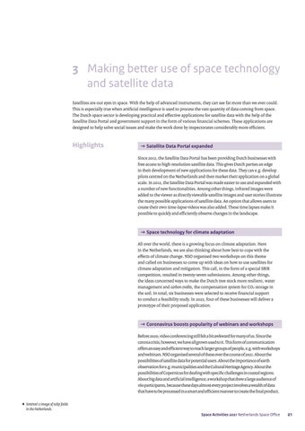
Sentinel-2 image of tulip fields in the Netherlands. Space Activities 2021 Netherlands Space Office
21


