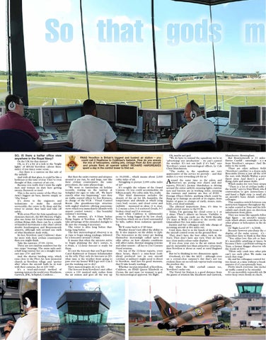
SO, IS there a better office view anywhere in the Royal Navy?
Or the UK for that matter? Ok, so it’s a bit of a trek to the ‘bright lights’ of RNAS Yeovilton (about three miles) if you fancy some scran... ...but there is a canteen on this side of the airfield. And with all that glass, it could be like a hothouse at this time of year. They’ve even thought of that, courtesy of air con. Because you really don’t want the eight men and women on duty here getting sweaty, flustered, or tired. This is the nerve centre of the Fleet Air Arm’s biggest air base, known simply as ‘The Tower’. It’s down to the engineers and technicians to make the aircraft serviceable, the crews to fly them and the tower to ensure they land and take off safely. With seven Fleet Air Arm squadrons (or elements thereof), the RN Historic Flight, plus one Army Air Corps formation and a civilian flying club, there can be a couple of hundred movements a day (that’s about double Southampton and Bournemouth airports, although only around one sixth of what Heathrow deals with). In fact, Yeovilton (and Culdrose) share far more with their civilian counterparts than you might think. Take the runways. 27/09. 22/04. These are not random numbers but the two strips’ bearings. The main mile-anda-half long runway lies on a straight westeast axis: 270˚ and 090˚. And the shorter landing strip, which runs close to the Fleet Air Arm memorial church in Yeovilton village and ‘spotter alley’ where the aircraft buffs lie in wait with their cameras, lies at 220˚/040˚. It’s a tried-and-tested method of naming runways the world over: Heathrow, Gatwick, JFK, Schiphol, Culdrose...
RNAS Yeovilton is Britain’s biggest and busiest air station – you could call it Heathrow to Culdrose’s Gatwick. How do you ensure the mix of helicopters, visiting jets, vintage Fleet Air Arm aircraft and private fliers all operate safely? RICHARD HARGREAVES spent a day in the control tower to find out. But then the entire runway and airspace around it are run, by and large, just like their civilian counterparts: the same procedures, the same phraseology. “We went to Amsterdam on holiday recently, waiting on the taxiway at Schiphol for ages to take off. We knew exactly what was happening,” says duty air traffic control officer Lt Zoe Bowness, in charge of the VCR – Visual Control Room (the greenhouse-type structure with angled windows offering panoramic views which you immediately identify with airport control towers) – this beautiful summer’s morning. In the summer, it’s 9.30am before flying begins at Yeovilton – the WAFUs take advantage of the extended daylight to fly into the evening if necessary. The tower is alive long before that. Long, long before. The first meteorological observer is in at 2am to begin taking readings, followed by a forecaster around 3.30am. It means that when the aircrews arrive to begin planning the day’s sorties, 6, 6.30am, a 12-hour forecast is ready for them. It’s not the forecast that you’ll get from Carol Kirkwood or Tomasz Schafernaker on the telly. They only do forecasts in 2D: what time is the weather front going to pass over my house? Will I get wet? Can I put the washing out to dry? Navy meteorologists do it in 3D. The forecast from Yeovilton’s met office covers a 100 nautical mile radius from the air station and goes all the way up
to 30,000ft... which means about 2,000 cubic miles of air. Struggling to picture 2,000 cubic miles of air? It’s roughly the volume of the Grand Canyon. Or you could accommodate six billion people. Per cubic mile. Yes, really. This third dimension includes the density of the air for lift, humidity, the temperature and altitude at which icing (very bad) occurs, and cloud cover and visibility – measured in oktas (0 is clear, 1-2 means a few, 3-4 scattered clouds, 5-7 broken cloud and 8 is overcast). And while Culdrose is (infamously) prone to being fogged in by low cloud, Yeovilton, which sits in a bowl surrounded by hills, suffers from radiation (ground) fog. We’ll come back to 2/3D later. Weather doesn’t just affect the ability to fly. It also impacts on the ability to fight. The forecasters in the tower are finding themselves increasingly called upon to offer advice on how climatic conditions will affect radar, thermal imaging systems and other sensors – all key to 21st Century Naval aviation. On top of the 12-hour reports, every three hours, there’s a nine-hour lookahead produced just in case aircraft (civilian or military) might need to divert to Yeovilton. And just for good measure, they’ll take hourly readings. Whether (no pun intended) atYeovilton, Culdrose, on HMS Queen Elizabeth or Ocean, the met man (or woman) is god. No meteorological approval. No flight.
Ok, maybe not god. “We do have to remind the squadrons we’re in ‘advertising’ not ‘production’ – we can’t control the weather. It’s not our fault if it’s bad,” says Yeovilton’s senior meteorological officer, Lt Cdr Chris Hutchinson. “The reality is, the squadrons are very appreciative of the service we provide – and that makes it a very rewarding job for us.” round the same time as the pilots and observers are poring over charts and met reports, PO(AC) Jucinta Marshalsea is driving around the entire airfield, ensuring lights, runway nets and barriers are in working order, ensuring the runways and taxiway are free of FOD – Foreign Object Debris: anything which could be flung up to damage an aircraft or its engine, from blades of grass to clumps of earth, stones, nuts, bolts, even dead animals. The physical inspections done, it’s time to climb several storeys to the VCR. Today, I’m guessing the cloud cover is 1 or 2 oktas. There’s almost no breeze. Visibility is excellent. You can easily see the 960ft Mendip TV mast at Wells (15 miles to the north) and Glastonbury Tor (ten miles away). Jucinta and her colleagues only take charge of incoming aircraft at five miles out. Until then, they’re in the hands of the team in the aircraft control room on the ground floor. They don’t have the best office view in the Navy. They don’t have any view. They do have nice clear multi-colour radar displays. If you close your eyes to the air station itself and its (invariably less-than-attractive) structures, then Yeovilton is about as rural as rural England gets. But we’re thinking in two dimensions again. Overhead, it’s like the M25 – although even on a crystal-clear summer’s day that’s not too evident; there are no tell-tale vapour trails scarring the peerless sky. But what the Mk1 eyeball cannot see, Yeovilton’s radar can. The Naval Air Station is a good distance from the giants of aviation like Heathrow and Gatwick,
A
Manchester, Birmingham. But Bournemouth is 33 miles Exeter. Cardiff – amazingly – is a m from Yeovilton’s airspace. And Bri miles to the north. There are other military fields (Yeovilton’s satellite) is a dozen mile Boscombe Down is just off the A30 the east, with Middle Wallop a prov throw away. And there’s a good flying clubs and minor fields. Which makes for very busy airspa “There is a lot of civilian traffic i the world,” says Lt Tony Ward, who b conversation to give instructions t and hand a flight strip (a small pla an aircraft’s basic details scribbled colleague. This seamless switch between con instruction happens throughout the in radar control as Tony and his fello calmly and clearly pass on direction information from pilots. They use terms like squawk, follow digit figure – an aircraft’s unique code which allows controllers on the other planes or helicopters in the ski them. Or ‘flight Level 65’ – 6,500ft. Because however pin-sharp the co display of the radar screen, it’s s controllers have to think in that third “You either love this job or hate It’s incredibly satisfying at times, bu because I have a problem-solving me Tony, a former Bagger observer who the world of ATC. “Pilots only crash into other pilo can’t see each other. We make sur reach that stage.” He and his colleagues control for n two hours at a time without a break minutes if it’s exceptionally busy. Pretty much everyone (me includ air traffic control to be stressful. It’s an incredibly responsible job. Bu tower keep stress firmly in check.