THE NORTH WEST Northwest Iceland is divided into seven municipalities: Akrahreppur, Blönduósbær, Húnaþing vestra, Húnavatnshreppur, Skagabyggð, Skagafjörður, and Skagaströnd. The largest fjord in North Iceland, Húnaflói, separates Northwest Iceland from the Westfjords. Three fjords lead inland from Húnaflói: Hrútafjörður, Miðfjörður, and Húnafjörður. The Heggstaðanes peninsula separates Hrútafjörður and Miðfjörður fjords, and the Vatnsnes peninsula separates Miðfjörður and Húnafjörður fjords. The shoreline is mostly low-lying, except the Vatnsnes coast. The Vatnsdalur valley stretches 25km inland and is lush and welcoming. A large, peculiar cluster of hills known as Vatnsdalshólar stretches across the mouth of Vatnsdalur valley. The lowlands give way to higher ground to the east, and deep valleys cut into the landscape. The area is also dotted with lakes, such as Miðfjarðarvatn, Vesturhópsvatn, Hópið, Húnavatn, and Svínavatn, which are all located near populated areas. Some of the main rivers are Hrútafjarðará, Miðfjarðará, Víðidalsá, Vatnsdalsá, Laxá á Ásum, Blandá, Svartá, and Laxá á Refasveit. All the rivers are excellent for salmon fishing. On the eastern side of Húnaflói lies the peninsula Skagi, which separates the Húnaþing and Skagafjörður districts. The municipality of Skagafjörður is a blossoming agricultural area. It’s home to the islands Drangey and Málmey. Drangey is a sheer island with a bedrock of palagonite, famous for its birdlife. For ages, Drangey has been a harbinger of spring for locals (they visited the island to collect both eggs and birds). Drangey also served as the refuge of Grettir Ásmundarson, from the eponymous Grettis Saga, during his exile. The shore of Skagafjörður is a vast lowland area, split by Hegranes at the fjord’s southernmost point. Farther inland, the region divides into the Austurdalur and Vesturdalur valleys on the southern side and the Norðurárdalur valley to the east. Route 1, the Ring Road, runs through the district over Öxnadalsheiði heath, towards Eyjafjörður. The largest watershed in Skagafjörður is known as Héraðsvötn, which is primarily fed by the eastern and western Jökulsá rivers, both of which originate from underneath the Hofsjökull glacier. The largest lakes in the district are Miklavatn in Borgarsveit, Höfðavatn on Höfðaströnd shore, and Miklavatn in Fljótaá. The area is beautiful in
the summertime, but the winters are often harsh with heavy snowfall. In spring, the vegetation often starts blooming underneath a layer of snow. The Héraðsvötn, Miklavatn, and Áshildarholtsvatn lakes are teeming with birdlife. The variety of bird species rivals that of the Mývatn area. The primary rock type in Northwest Iceland is basalt. Six- to eightmillion-year-old basalt can be found in the Húnaþing area, while the basalt in Skagafjörður formed about 12 million years ago. Glaciers largely shaped the landscape during the last Ice Age. Younger rock types have been discovered in several areas, and lava fields in Skagi consist of dolerite. Ancient volcanoes, which contain rhyolite and metamorphic rock formations, have been discovered in the area, such as Mt. Vatnsnesfjall, Mt. Víðidalsfjall, and the Staðarfjöll mountains (south of Mt. Tindastóll). The area is geothermally active. Thermal water is used for central heating. Vegetation in the area is thriving and consists mostly of grassland and marshes. Skagafjörður also has sedge meadows. There are few areas of shrubbery or woodland in the district. Northwest Iceland has been an agricultural area since ancient times. Siglufjörður has long been a hub for fishing; its favourable natural harbour helped it become a centre of commerce in the latter half of the 19th century. Siglufjörður grew considerably in the first half of the 20th century due to an increase in herring fishing. Fishing increased significantly in other places after 1920, and together with fish processing, trade with nearby regions, and growing industry, it resulted in the formation of several new townships. Sauðárkrókur, Hvammstangi, Skagaströnd,
NORTH WEST
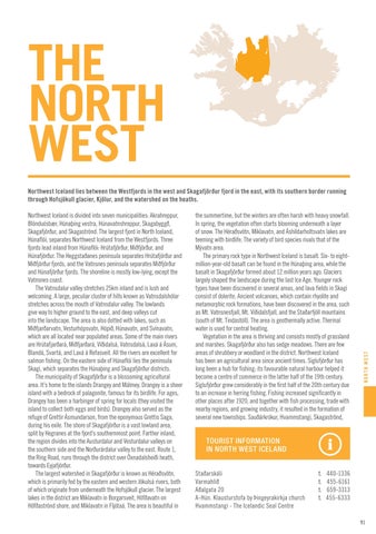
Northwest Iceland lies between the Westfjords in the west and Skagafjörður fjord in the east, with its southern border running through Hofsjökull glacier, Kjölur, and the watershed on the heaths.
TOURIST INFORMATION IN NORTH WEST ICELAND Staðarskáli Varmahlíð Aðalgata 20 A-Hún. Klausturstofa by Þingeyrakirkja church Hvammstangi - The Icelandic Seal Centre
t. t. t. t.
440-1336 455-6161 659-3313 455-6333
91


