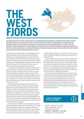
THE WEST FJORDS The Barðaströnd coastline extends from the Vatnsfjörður fjord and Sigluneshlíðar in the southern region of the Westfjords. Rauðasandur, a beautiful sandy beach, is located nearby. The sheer Látrabjarg cliffs rise 440m out of the sea and end at Bjargtangar, the westernmost point of Iceland and Europe. South of Barðaströnd lies the Breiðafjörður bay, known for its innumerable islands, the largest of which is Flatey, which was home to a flourishing community up until the mid-20th century. The coastline of the Ísafjörður municipality is longer than any other municipality in the country; nowhere in Iceland are there so many small fjords. Throughout the area, there is very little lowland. The fjords are separated by high mountains, which have impeded transport between neighbouring villages since the times of the settlement. Many areas are threatened by the danger of avalanches. The fjords are long and deep, and favourable harbour conditions abound. There are few lakes in the area, and most rivers are short. Ísafjörðurdjúp boasts the largest cluster of fjords in the country. The Æðey and Vigur islands are known for eiderdown farming (the most significant production is, however, found at Mýrum and Lækur in Dýrafjörður). There are seven fjords of varying sizes on the southern side of Ísafjörðurdjúp, with the Jökulfjörður fjord situated on its northern side. The surrounding area has a tremendous landscape that is sparsely vegetated. The Rytur headland guards the entrance to Ísafjörðurdjúp to the north, the Vík area to the east towards the Horn headland, and the Hornstrandir cliffs can be found between the Hornbjarg cliffs and the Geirólfsnúpur headland. In earlier times, Hornstrandir was well populated, and the inhabitants based their livelihood on the sea and bird cliffs. Today, the area is abandoned. There was a settlement at Hesteyri in Hesteyrafjörður until the latter part of the 19th century. During the time, inhabitants staffed a whaling station and a herring factory. Hornstrandir is a protected nature reserve that boasts
a wealth of popular hiking trails. The nature reserve covers 580 km2 and includes the Fljótvík and Aðalvík bays, along with the Jökulfjörður fjords. A trip to Hornstrandir requires careful planning and the rules applying to reserve must be respected. Travellers should note that weather conditions in the area can be exceedingly hostile, with mobile phone signals often being rather weak. It is, therefore, vital to carry adequate provisions and a good map. Further information can be obtained from the Environment Agency of Iceland, the Westfjords Natural History Institute, and the tourist information centres in Ísafjörður and Hólmavík. The eastern side of the Westfjords saws the western shore of the Húnaflói bay. Bays and fjords abound along the shoreline, with sheer mountains separating the fjords. The fjords are mostly small, with the longest being Steingrímsfjörður and Reykjarfjörður fjords. Many islands and skerries can be found along the coast (Grímsey island is the largest). Owing to a harsh climate and barren land, the northern coast is no longer inhabited. Shark fishing was formerly practised at Gjögur, once a well-known fishing station.
WESTFJORDS
The largest peninsula in Iceland, the Westfjords are situated between the Breiðafjörður and Húnaflói bays. With its distinct serrated coastline and numerous fjords, there is relatively little coastal lowland in the Westfjords. The highlands of the Westfjords, which are rocky with sparse vegetation, are situated inland. The Drangajökull glacier sits in the north of the peninsula, the fifth largest glacier in Iceland. Basalt is the main type of rock found in the Westfjords, generally stratified with lava stacks, and in many places, fossilised plants have been discovered in between layers of lava.mountain and shore becomes very narrow. West Iceland contains many historical sites.
TOURIST INFORMATION IN THE WESTFJORDS · · · · ·
Reykhólar - Maríutröð t. 434-7830. Hnjótur - Örlygshöfn t. 456-1511. Tálknafjörður t. 456-2639. Ísafjörður - Aðalstræti 7 t. 450-8060. Bolungarvík t. 450-7010 in summer 69


