Change Number
Zoning Change
Area of Change
Planning Area
Tax Map and Grid
Tax Account
Prior Zoning Approval(s)
18
R-R to C-O
26.85 acres
85A
144-E2 144-F2
1133131, 1142850 1175439, 1156090 1138411, 1138395 1138403
SMA, 9/14/1993
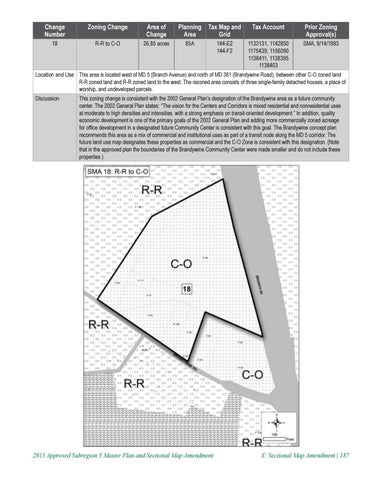
Location and Use This area is located west of MD 5 (Branch Avenue) and north of MD 381 (Brandywine Road), between other C-O zoned land R-R zoned land and R-R zoned land to the west. The rezoned area consists of three single-family detached houses, a place of worship, and undeveloped parcels. Discussion
This zoning change is consistent with the 2002 General Plan’s designation of the Brandywine area as a future community center. The 2002 General Plan states: “The vision for the Centers and Corridors is mixed residential and nonresidential uses at moderate to high densities and intensities, with a strong emphasis on transit-oriented development.� In addition, quality economic development is one of the primary goals of the 2002 General Plan and adding more commercially zoned acreage for office development in a designated future Community Center is consistent with this goal. The Brandywine concept plan recommends this area as a mix of commercial and institutional uses as part of a transit node along the MD 5 corridor. The future land use map designates these properties as commercial and the C-O Zone is consistent with this designation. (Note that in the approved plan the boundaries of the Brandywine Community Center were made smaller and do not include these properties.)
2013 Approved Subregion 5 Master Plan and Sectional Map Amendment
X: Sectional Map Amendment | 187