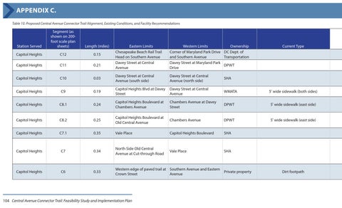
APPENDIX C. Table 10. Proposed Central Avenue Connector Trail Alignment, Existing Conditions, and Facility Recommendations
Station Served
Segment (as shown on 200foot scale plan sheets)
Length (miles)
Capitol Heights
C12
0.15
Capitol Heights
C11
0.21
Capitol Heights
C10
Capitol Heights
Eastern Limits Chesapeake Beach Rail Trail Head on Southern Avenue Davey Street at Central Avenue
Western Limits Ownership Corner of Maryland Park Drive DC Dept. of and Southern Avenue Transportation Davey Street at Maryland Park DPWT Drive
0.03
Davey Street at Central Avenue (south side)
Davey Street at Central Avenue (north side)
SHA
C9
0.19
Capitol Heights Blvd at Davey Street
Davey Street at Central Avenue
WMATA
Capitol Heights
C8.1
0.24
Capitol Heights Boulevard at Chambers Avenue
Chambers Avenue at Davey Street
DPWT
5' wide sidewalk (east side)
Capitol Heights
C8.2
0.25
Capitol Heights Boulevard at Old Central Avenue
Chambers Avenue
DPWT
5' wide sidewalk (east side)
Capitol Heights
C7.1
0.35
Vale Place
Capitol Heights Boulevard
SHA
Capitol Heights
C7
0.34
North Side Old Central Avenue at Cut-through Road
Vale Place
SHA
Capitol Heights
C6
0.33
Western edge of paved trail at Southern Avenue and Eastern Private property Crown Street Avenue
104 Central Avenue Connector Trail: Feasibility Study and Implementation Plan
Current Type
5' wide sidewalk (both sides)
Dirt footpath