11 minute read
BEYOND THE BURN: FIVE SPECTACULAR MT. JEFFERSON HIKES THAT SURVIVED THE FLAMES

by Matt Reeder
I grew up in the shadow of Mt. Jefferson, in Salem. We moved from Illinois to Oregon when I was seven years old, and before long my stepdad and I were exploring the Majestic Mt. Jefferson region on a regular basis. When I moved back to Oregon in 2005, I set about exploring this area again. This culminated in spending the spring, summer and fall of 2014 and 2015 researching and writing my guidebook 101 Hikes in the Majestic Mount Jefferson Region.
Writing this book was a dream of a lifetime, and I still regard it as the best of my four guidebooks. Unfortunately, the area covered in this book—from the Bull of the Woods Wilderness to the Old Cascades and from Olallie Lake to the eastern side of the Mt. Jefferson Wilderness—has burned repeatedly since the publication of my book. The Opal Creek area burned particularly hot, and the whole canyon is now completely unrecognizable. With so much damage and so much of this area scarred by fire, my plans to publish a second edition of 101 Hikes are on hold indefinitely.
That being said, there are still many places in this beautiful area that have escaped the ravages of the past decade! Here are five of my favorite places where you can still hike in forest that is mostly unburned, and all five are emblematic of how this entire area looked during my childhood, when I fell in love with the Majestic Mt. Jefferson region. The following hikes I have done in the past two years as I return to this area to explore once again.
Bagby Hot Springs
Hike stats: 3.2 miles out and back with 300 feet of elevation gain. This hike can be extended into a much longer day as desired, but eventually you will hit fire damage as you hike deep into the Bull of the Woods Wilderness.
Hike notes: When I first moved to Portland some twenty years ago, Bagby Hot Springs was among the most popular destinations in the state of Oregon. The place had taken on a mythical status, as many hot springs do. Visiting the springs was not without hazard; rumors of car break-ins abounded, and many folks got lost trying to find the place as Google Maps directed them on a long series of forest roads far above the peaceful valley where the springs are located. Over the years, Bagby lost its reputation; the hot springs became notorious for bad behavior, and then a concessionaire took over management of the springs, further adding to the confusion surrounding the place. The fires in 2020 closed much of the Clackamas River canyon and burned over the upper reaches of the Bagby Trail, further driving people away from the area.
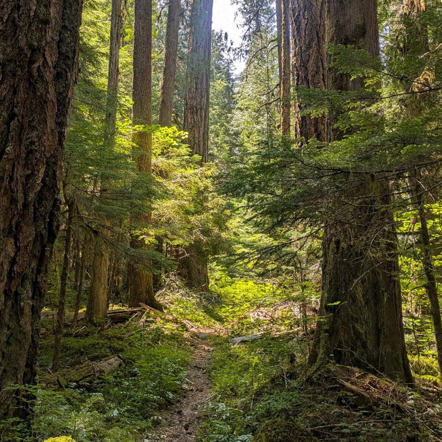
The Bagby canyon never burned, however. It still looks as beautiful as it ever has, with massive Douglas-firs and Western Red-cedars towering over the trail. With nearby Opal Creek burning to the ground and the valleys of Elk Lake Creek, Dickey Creek, and Pansy Basin scarred by fire, the valley that holds the hot springs remains the only valley that has mostly avoided fire damage. Better yet, a concessionaire is now operating the hot springs, and there is someone watching the trailhead at all times throughout the summer, so the break-ins that plagued this trailhead in the past are no longer an issue. The much-loved bathhouse was condemned, and other accommodations are in the process of being built. It is a fascinating place. If you’re planning on a soak, you’ll need to stop at the Ripplebrook store or at the trailhead itself and pay $5 per person. If you aren’t planning on a soak, you won’t need to pay anything. Beyond the hot springs, the trail enters the Bull of the Woods Wilderness and becomes narrower, a true wilderness trail. Trail crews cleared the trail in 2024 and as of this writing, most of the trail is in the best shape it’s been in a long time. Hiking though the ancient forest is soothing and deeply peaceful—may it remain so for all times.
Battle Ax
Hike stats: 5.6 miles out and back with 1,800 feet of elevation gain. This hike can be extended in every direction, as there are trails spreading out in every direction from the trailhead.
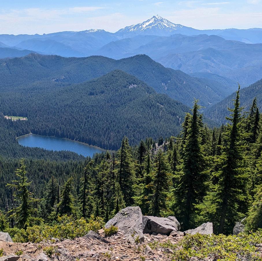
Hike notes: The trail up to the summit of Battle Ax is one of the most beautiful hikes in the Central Oregon Cascades. Here the Cascades spread out from Mt. Rainier to Diamond Peak, while wildflowers carpet the slopes profusely throughout the summer, especially in July. Elk Lake shimmers below you, with Mt. Jefferson close behind on the horizon. The summit of Battle Ax was an island in the 2020 and 2021 fires, and the forests below mostly survived intact. Exploration further from Battle Ax will lead you to some of the few pockets of ancient forest that survived in this area. While everything around here burned, this area is still achingly beautiful. The only downside is the awful road to the trailhead. Any car as sturdy as a Subaru Outback can handle the drive to
Elk Lake, but it isn’t pleasant. Once you are there though, you won’t want to leave. Follow the old mining road to the Bagby Trailhead (the southern terminus of the Bagby Trail above) and continue up the old road, now a trail, to Beachie Saddle at 1 mile. The loop begins here. The trail to the summit of Battle Ax gains 1,200 feet in 1.6 miles but is mostly well-graded. The views from the summit, an old lookout site, are every bit as spectacular as advertised. To complete the loop, follow the narrow trail north from the summit through dense woods until the trail intersects the Bagby Trail. From here, you’ll turn right to hike back to the trailhead you passed earlier. Along the way you pass great views to the summit of Battle Ax, hike through a dense swamp where brush crowds the trail, and finally, an excellent view down to Elk Lake and out to Mt. Jefferson.
Coffin And Bachelor Mountains
Hike stats: 3 miles out and back with 1,047 feet of elevation gain for Coffin Mountain, 3.8 miles out and back with 1,200 feet of elevation gain for Bachelor Mountain
Hike notes: These two peaks just south of Detroit Lake both offer incredible displays of July wildflowers and fantastic views of Mt. Jefferson and all up and down the Cascades. Each makes for a satisfying destination on its own but combined, it is truly the best of all worlds. There are two other trailheads for Bachelor Mountain that also offer longer, spectacular hikes, but then you would not have the pleasure of also hiking Coffin Mountain. Both hikes missed the 2020 fires as they were just south of the burn –you’ll see lots of damage to the north, but none to the south.
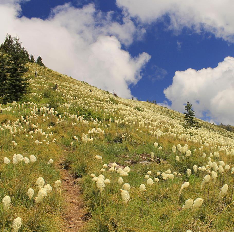
For Coffin Mountain, you’ll hike up a steep trail into the huge meadows below the mountain’s summit. In some years, the display of beargrass in these meadows is truly breathtaking, and among the most impressive in the entire Oregon Cascades. The trail reaches the summit at 1.5 miles, where you will see a lookout that is staffed in the summer. The staffer may come out to say hello but otherwise do not bother them while they work. A better job would be hard to imagine.
For Bachelor Mountain, you’ll drive another 0.7 mile up the road and turn left on the narrow road that leads to the Bachelor Mountain Trailhead. The trail climbs first through the woods and then through huge meadows with views of Mt. Jefferson, less than ten miles to the east. The flower display here is tremendous, with dozens of species of flowers growing together in great profusion – more than I could ever list here. A side trail leads steeply uphill to the summit, where the view is just as good as it is at Coffin Mountain.
Marion Lake
Hike stats: 6.2 miles out and back with 1,200 feet of elevation gain
Hike notes: Marion Lake is the largest, deepest, and arguably the most spectacular lake in the Mt. Jefferson Wilderness. The lake has a long and storied history. Once the site of summer cabins and boats kept in the lake year-round, the lake is now a crossroads in the wilderness and an immensely popular destination. You’ll need a permit to hike here, for day use or overnight, until the middle of October. But Marion Lake is always worth it! In addition to the lake, there is also a spectacular waterfall, verdant and mossy forest, and excellent views of Mt. Jefferson if you know where to look.
From the trailhead, the Marion Lake Trail passes through deep forest and begins climbing, reaching scenic Lake Ann at 1.4 miles. Continue past the lake and reach a fork at 1.8 miles. Left leads you directly to the lake but I prefer to take the scenic route, so turn right. In just 0.2 mile, look for an unsigned but obvious path on the right.
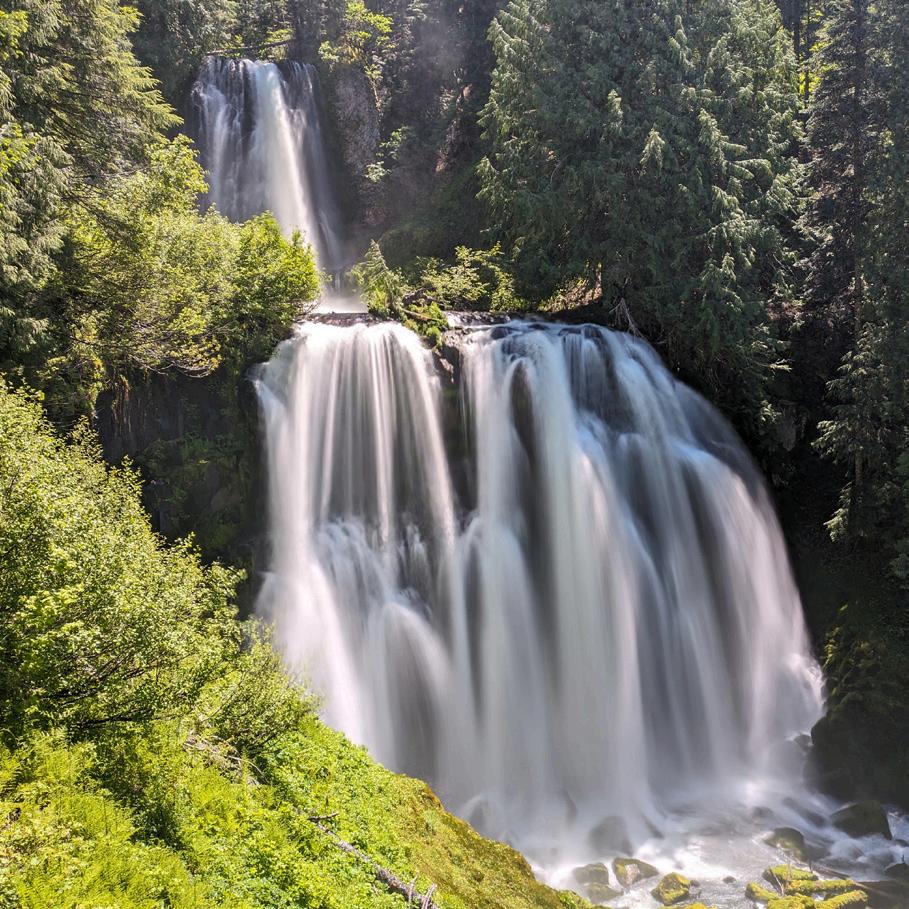
If you wish to visit Marion Falls (whose lower tier is sometimes called Gatch Falls), turn right here and follow this unmaintained and unofficial trail to Marion Creek, then turn right and descend to Marion Falls. The lower tier is much more exposed but still relatively easy to access if you don’t mind some exposure. Back on the trail, follow it to a bridge over Marion Creek. To continue the loop, turn left. But if you’re looking for a view of Mt. Jefferson, turn right and cross the bridge. Continue another 0.2 mile across a talus slope until you see a trail heading back towards the lake. This takes you to a campsite. For a view of the mountain, scramble down the slope to lake level, where the mountain absolutely towers over the lake. This is a nice lunch spot, away from most of the crowds you’ll encounter here. From here, return to the loop trail and hike it around the lake. When you reach a four-way junction at the northwest shore of Marion Lake, turn left to hike 2.2 miles back to the trailhead.
CANYON CREEK MEADOWS
Hike stats: 7.9 mile semi-loop, 1,600 feet of elevation gain
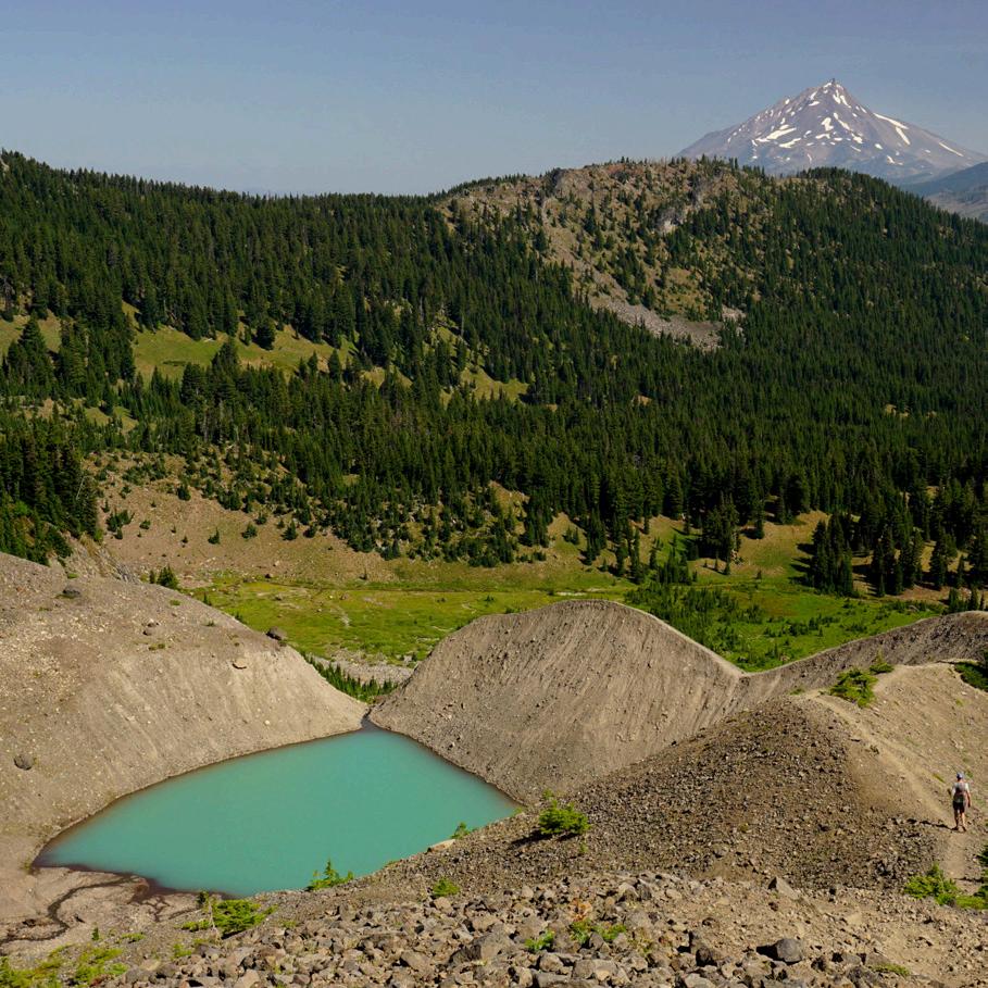
Hike notes: Canyon Creek Meadows is one of the most spectacular spots in the Mt. Jefferson Wilderness. The lower reaches of this hike were scorched in the massive B+B Fire in 2003, but all these years later, the forest is coming back, and the burn damage is less noticeable with each passing year. The area around Canyon Creek Meadows at the foot of Three-Fingered Jack never burned and the meadows and views here are among the most spectacular in the Oregon Cascades. As with Marion Lake, this place is extremely popular, and you’ll need a permit for both day hiking and for backpacking.
The hike begins at Jack Lake, once the site of a primitive campground. If you’re camping, look for sites away from the lake. Follow the trail for 0.4 mile to a fork in the trail. Turn left here. You’ll hike uphill through recovering forest until the trail drops into the valley holding Canyon Creek Meadows, where you’ll leave the burn behind for the time being. At a junction at 2.2 miles, turn left on the unofficial but heavily used Glacier View Trail. This trail soon enters the meadows for which this area is famous, with Three Fingered Jack towering over the trail. The Glacier View Trail gets a little faint but continues up the side of a glacial moraine to viewpoint of a turquoise lake at the base of the mountain, at the terminus of Three-Fingered Jack’s now extinct glacier. The trail continues steeply uphill to a pass at 3.8 miles, elevation 6,500 feet. The view here is eye-popping! The Three Sisters and Broken Top dominate the skyline to the south, while Mt. Jefferson rises to the north. The upper slopes of Three-Fingered Jack tower over this pass. Mountain goats are frequently seen in this area. You’ll want to take your time and really savor this place –I’ve been many times, and it never gets old. It never could.
To continue your loop, return to Glacier View junction in the meadow and continue south. Mosquitoes can be a major nuisance here. Before long you’ll enter more fire damage from the B+B Fire, but as with the other part of the trail, this area is beginning to recover nicely. You’ll reach a junction with the Old Summit Trail at 6.3 miles. Turn right here to hike 1.6 miles back to the trailhead.