12 minute read
Michael di Giovinazzo, William Harding, Christopher Bray Beng: Consulting in the Nordic region

from Materia 5/2023

SRK’s consultants focus on providing value-adding services to mining and exploration clients including major and junior mining and exploration companies, as well as lending institutions. Recent developments in geopolitics are increasing the importance of the supply of domestic raw materials in Europe where northern Europe plays a major role. Therefore, it is a vital part of the mining business that consulting practices offer services for exploration, mining, and operational support by bringing knowledge and best practices to the industry.
SRK supports clients on due diligence studies, valuations, CPRs, financial modelling, open pit and underground rock mechanics and mine planning, rock mass and water numerical modelling, mineral resource estimation, geological modelling and on the geotechnical engineering of operations. This article will give some insights to projects that SRK has recently been involved with in Finland.
Geotechnical Data in Nordic ProjectsBeyond RQD
Whilst geotechnical data is vital to operating pits and underground mines, simple rock mass quality data can provide a solid foundation for an understanding of the rock mass at an early stage in a mining study process. This data can be collected from the initial resource drilling programmes for little extra time and cost but adding large technical value to a project. As a result, and as the project matures from advanced exploration into early-stage mining assessments, there is a platform of data which limits the extent and requirement for specific geotechnical and hydrogeological drilling campaigns with associated cost and schedule savings to the project advance through the study stages.
SRK’s experience in the Nordic region has highlighted that there is generally a good acknowledgement for basic geotechnical data collection during geological logging campaigns. However, this is often limited to core recovery, measurement of RQD, and some structural logging of the oriented core - with the standard and quality of many data sets variable.
The cause of poor-quality geotechnical data at the resource drilling stage is often simply a lack of understanding of why the data is collected and how it is applied. With simple training, the context and value of how geotechnical data will eventually be applied in mining studies will be understood by the existing geological logging teams. The project owners are better informed of the value of the data they collect (for minimal additional effort) and it is then useful for elements of rock mass characterisation and hydrogeological appraisal which assists early-stage mining studies.
SRK has developed or adapted the existing logging systems for several clients in order to establish an industry accepted standard in useful geotechnical data capture. Existing logging systems that operate in generic or proprietary software systems have been re-organised and modified to meet a minimum standard of rock characterisation to enable the calculation in various rock classification systems.
Additionally to RQD correctly collected the introduction of the collection with a few other parameters enables the confident calculation of ratings in multiple rock classification systems. Each system has 3-4 categories, but if an extra 1-2 parameters are collected, then independent calculation in the various classification systems is possible. After basic training to the same logging team, the logging time increases by 10-20% to collect enough parameters to estimate rock strength, frequency of open fractures, how many sets (similar 3D orientation) of fractures, and what is the condition of the fractures and infill.
When ‘full’ geotechnical logging is done to characterise the rock mass, logging parameters are chosen to calculate ratings for a rock mass classification system independently. Conversion formulae are possible but should not be blindly applied as they were not originally established for extensive application in every rock mass environment.
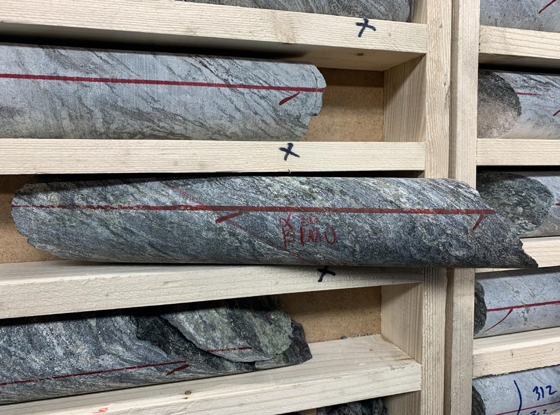
The quality and volume of oriented core for point structural logging is generally good in Nordic programs. Additional to resource modelling, the orientation and spacing of fractures is vital to understand the block sizes of the rock mass in 3D - and the joint surface and infill condition can also be logged easily at each entry. This assists in understanding which controlling fracture group will influence the stability of an excavation oriented in a particular direction. Major fracture zones and also variably healed fabric (like foliation) can be modelled in 3D which supports resource modelling, hydrogeological assessment and estimation of whether rock will fracture under high mining induced stress.
Early rock strength testing methods has using field strength testing has been implemented in the logging facilities of a number of Nordic projects using Point Load Testing (PLT) machines. These machines are mobile, easy to set up, operation quickly learnt, and applied effectively by the geological logging team. Coupled with a simple field index of the logger’s strength estimation of the core, the PLT testing provides many data points and a large data set that will later be correlated with the higher cost but essential laboratory rock testing. The initial relative variation in rock strength is provided across the deposit rock mass which is very useful not only for mining studies, but also as a guidance input into blastability index estimation, excavatability estimation, and rock crushing requirements.
MICHAEL DI GIOVINAZZO, BSC, GCERTENG, AUSIMM, ISRM PRINCIPAL MINING GEOMECHANICS ENGINEER
Hydrogeological and Geochemical Modelling Study for the Kittilä Mine
SRK was commissioned by Agnico Eagle in 2019 to undertake hydrogeological and geochemical modelling of the Kittilä gold mine in Finnish Lapland (1). The purpose of the study was to predict future inflows to the underground mine and the quality and chemical loading of the mine discharges to assess whether there is an adequate treatment capacity to ensure environmental permit compliance.
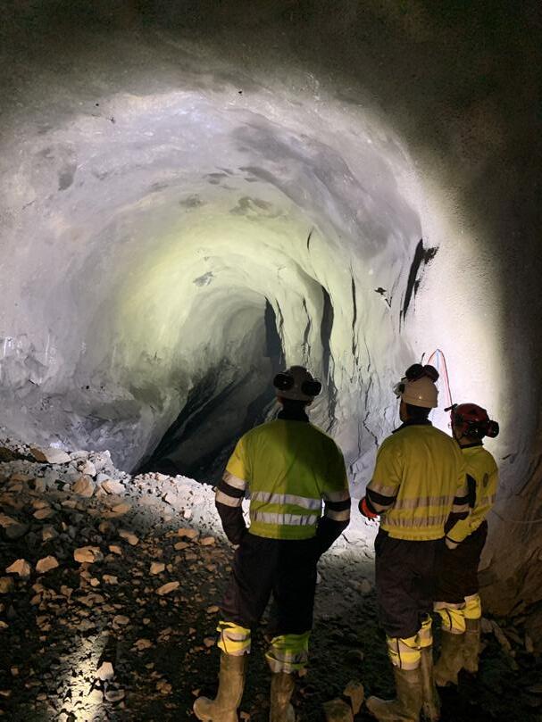
The study consisted of an initial appraisal of existing data, both to learn about the Kittilä operation in its physical and geochemical setting and to establish information gaps. This was followed by a surface and underground field-testing campaign to acquire hydrogeological and geochemical data (Figure 1) and the development of geological and structural models for the deposit through the very successful collaboration of Agnico Eagles’s site geology team and the SRK structural geologists. The resulting Leapfrog model coupled with the latest mine design and development schedule formed the basis for the numerical groundwater model, the main purpose of which was to generate a schedule of mine inflows for use in the subsequent geochemical model. The latter model also drew on the geochemical characteristics of the ore and groundwaters in the surrounding rock mass to predict concentrations and loadings of specific chemicals that were listed in the Environmental Permit for the mine. The primary object of the modelling was to establish whether, by how much and when chemicals listed in the permit might exceed the stated discharge limit.
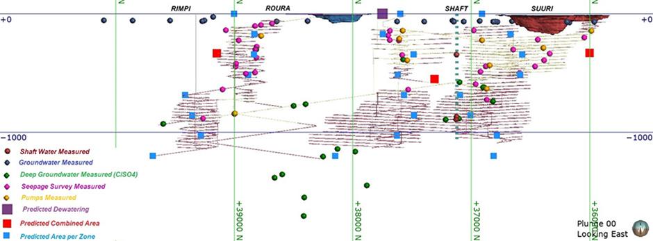
Over the years, the Client has acquired a significant body of information covering local lithologies, geological structures, hydrogeology and rock mass chemistry and this enabled SRK to develop a detailed conceptual understanding of the local surface and groundwater regime. The resulting transient, groundwater model, which was built using Modflow USG predicted that inflow to the underground mine would peak around 11 years after the onset of mining and thereafter it would undergo a steady decline for the remaining period of operation. The pattern of behaviour produced by the model was benchmarked against other operations globally and, consequently, SRK was able to show that the model outcome was reasonable in relation to Agnico Eagle’s plans for the Kittilä mine at the time of the study.
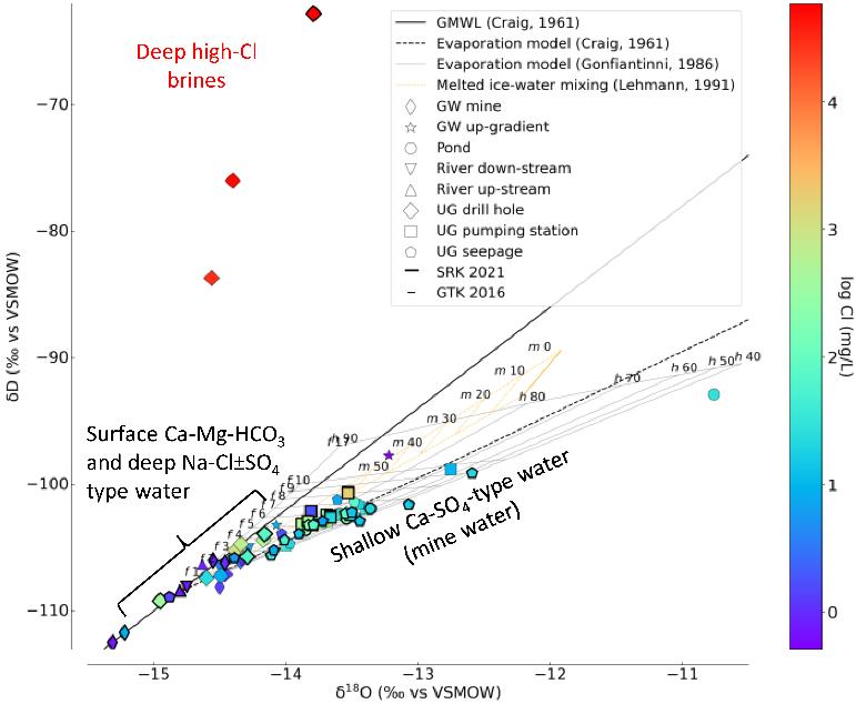
The predictive geochemical modelling was undertaken by SRK using a combination of mass balance techniques in Microsoft Excel and thermodynamic calculations using the United States Geological Survey (USGS) thermodynamic code PHREEQC. It was developed using the flow rate schedule generated by the groundwater model coupled with background groundwater chemistry and elemental release rates from the progressive development and exposure of underground wall rock and rock fill to mine water. In addition, SRK undertook a tracer study to identify the primary water sources and their respective contributions to the mine discharge (2). This work showed that most underground mine water at Kittilä is of meteoric origin: the isotopic composition of the surface Ca-MgHCO3-type water and the deep Na-Cl±SO4type water, together with chemical evidence of mixing, pointed to a genetic link between these two endmembers, which is consistent with the presence of conductive geological structures in the Kittilä Shear Zone that facilitate recharge from the surface (Figure 2).
Overall, SRK’s combined hydrogeological and geochemical approach was successful in predicting the temporal and spatial distribution of major ion and metal concentrations and their loadings, as listed in the Environmental Permit.
WILLIAM HARDING MSC, FGS, CGEOL PRINCIPAL CONSULTANT, HYDROGEOLOGY
(1) SRK would like to thank Agnico Eagle very much for their consent to share this overview of the project in the public domain.
(2) Ref.: V. Milesi, J. Declercq, W. Harding, T. Jarman, O. Baas, J. Saukkoriipi, A. van Wageningen, R. Bowell; June 2023; Chemical and Water-Isotope Composition Unravels the Source and Evolution of the Kittilä Underground Mine Water, Kiistala, Finland. Publ.: Mine Water and the Environment
Rajapalot Trade-off Assessment and Preliminary Economic Assessment (PEA)
SRK recently completed a mining method trade-off assessment followed by a Preliminary Economic Assessment (PEA) on the Rajapalot Gold-Cobalt Project (the Project) in Northern Finland for Mawson Gold Limited (Mawson). The Project comprises five orebodies (Palokas, Raja, Joki East, The Hut and Rumajärvi) within an area of approximately 3 km from west to east and 2 km from south to north, which commence from outcrops to 100 m below the surface, to a maximum depth of around 600 m.
The initial challenge of the trade-off assessment was to evaluate the range of scenarios to determine the base case strategy for the PEA including the scale and layout of the Project and approach for each orebody considering mining and backfill method, production rate potential, sequence, materials handling, ventilation, processing and waste management options. SRK has continued to develop the trade-off model approach in recent years which was prepared for the Project to assess up to 5 mines or zones with the following functionality:
• Considers up to 10 metal (or deleterious element) grades and 4 saleable products (concentrates and metals).
• Variable Net Smelter Return (NSR) cut-off values can be applied per mine or zone with average grades reported and scheduled per mining level.
• Up to 4 mining methods per mine or zone can be utilised with variable modifying factors applied.
• Variable production rate for each mine or zone can be applied per period (annual).
• First principle capital and operating costs are estimated throughout the mine schedule, based on equipment and personnel requirements.
• Includes functionality to switch between owner-operator and contractor mining for various development and production activities.
The PEA mine plan for Rajapalot considers a greenfield underground operation targeting a run-of-mine (RoM) production rate of 1.2 Mtpa through combined mining of three deposits at any one time to meet the target annual production. The production rate potential for each of the deposits was determined through an assessment of the tonnes per vertical metre and typical annual decline advance rates. The overall production target was set at 1.2 Mtpa which could be sustained over a 9-year period. The production strategy considers continuous mining of the larger two deposits (Palokas and Raja) over the life of mine (LoM) and mining the smaller three deposits (Joki East, The Hut and Rumajärvi) sequentially with the order determined by earlier mining of higher gold grades.
Each of the near surface deposits are planned to be individually accessed through decline box cuts with truck haulage to the RoM stockpile located at the process facility. RoM material was assessed against an economic cut-off for cobalt extraction, to be separately stockpiled, and campaign processed. All feed is planned to be processed for gold recovery but only a proportion, on a feed campaign basis, for cobalt recovery.
The trade-off assessment considered a range of mining methods including fill and non-fill approaches. The primary mining method selected for the Project is retreat longhole open stoping (LHOS) with a 20 m level spacing and applied to the Palokas, Raja, The Hut and Rumajärvi) deposits. Paste backfill is used to maximise mining extraction and reduce the tailings storage requirements on surface. The mining method selected for the Joki East deposit is overhand Cut and Fill (C&F) due to its shallower dip angle with Cemented Rock Fill (CRF) (Figure 3).

A NSR Cut-off Value (CoV) of approximately USD52 per mined tonne was applied for the Rajapalot stope optimisation, based on initial estimates of mining, processing and general and administrative (G&A) operating costs. The Deswik Stope Optimiser module was used to generate mineable shapes with applied modifying factors (mine dilution and losses) to quantify the RoM inventory used as a basis for the LoM schedule.
The annual production schedule, which includes an allowance for production ramp up, is used to derive an equipment fleet schedule including commissioning and replacement periods over the duration of the mine life. Fixed and variable labour is estimated according to the equipment requirements for each annual period based on the development and production schedule physicals. The mine operating cost estimate assumes an owner-operator approach, as is typical in Finland, with mine equipment purchased via a lease-to-own strategy on typical industry terms.
SRK consultants prepared a preliminary mine dewatering model that was developed and calibrated using hydrological parameters from other regional projects and similar geological settings. An allowance for mine and surface water management infrastructure has been provided for the preliminary estimate of water quantities. ▲
CHRISTOPHER BRAY BENG (MINING), MAUSIMM(CP) PRINCIPAL CONSULTANT, MINING
PHOTO: SRK CONSULTING FINLAND OY


