FEATURE
Hydrography and underwater surveys
Survey work boosts business for marine services company After a busy 2014, the Subtech Survey Division headed into the New Year finalising deliverables on a high-profile feasibility study for port development in KwaZulu Natal consisting of a bathymetry and geophysical survey.
T
he acquisition phase of the project was completed in early January and the project consisted of over 300 hours of operations and 1,250 km of survey lines. The final project deliverables will be submitted in the first quarter of 2015. Subtech has an established hydrographic survey capability which includes single beam, multibeam, side scan, magnetometer and sub-bottom survey experience, together with services such as water level monitoring, current and tidal analysis, sound velocity and water property measurements. Subtech Survey Division can also of-
fer supplementary and complementary surveys through its established network of professional survey companies, LiDAR surveys, 3-D scanning, topographic, mining and engineering surveys. 2014 was a busy year for the survey division with projects including
Beach and bathymetry surveys supporting port development in the Western Cape;
Single beam and vertical control
surveys supporting jetty construction and logistical access in Mozambique for the Subtech Project Division;
Single beam hazard identification
and logistical support for wreck removal in Madagascar;
Multibeam bathymetry surveys in
support of a major salvage operation in KwaZulu-Natal;
Multibeam bathymetry survey to
provide relevant information for the construction of a jetty extension in Mozambique;
Multibeam bathymetry surveys for
hazard identification for oil rig access at various ports in South Africa;
Topographic and beach surveys for
environmental impact assessments and engineering feasibility studies for infrastructure development in Mozambique;
Bathymetry surveys to manage and
measure the progress of dredging projects in Kwa Zulu-Natal and Free State;
Side scan and multibeam survey to
identify and recover lost containers and to ensure safe, effective and efficient removal by the Subtech Diving Division;
Topographic and beach surveys to
determine potential hazards and best routes prior to cable and pipeline laying operations;
Multibeam bathymetry surveys to
support, measure and monitor dredging and construction projects in the Port of Durban by the Subtech Construction and Marine Divisions;
Bathymetric surveys to monitor and assess effluent pipeline conditions and support dredging and maintenance operations by the Subtech Marine Division;
Topographic and bathymetric single
beam surveys using a jet ski and paddle ski to determine water levels for Local Government Water Authorities.
Subtech Survey owns two multibeam survey systems, one of which is permanently fitted to IMCA and SAMSA certified survey vessel Subtech Odin, which can be containerised and shipped worldwide and supported by an experienced survey skipper and survey personnel. “Our systems deliver and produce accurate and repeatable results through our continual equipment optimisation, instrumentation software and firmware upgrades, preventative and planned maintenance routines, regular calibrations and training of personnel in the current and optimal use of equipment, resources and vessels,� says Neil Scott-Williams of Subtech who adds that their goal is to meet or exceed the International Hydrographic Organisation (IHO) most stringent Special Order accuracy standards and deliver to the client a product which is professional, comprehensive, compliant and relevant. Subtech can offer a total solution for on-shore, near-shore and transitional zone hydrographic and geophysical surveys through global partnerships in the industry. “We have comprehensive skill
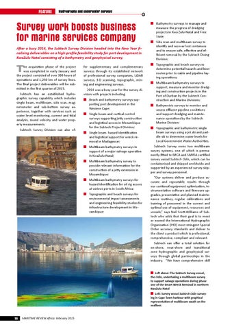
Left above: The Subtech Survey vessel,
the Odin, undertaking a multibeam survey to support salvage operations during phase one of the Smart Wreck Removal in northern KwaZulu-Natal
Left: Survey vessel Subtech Odin surveying in Cape Town harbour with graphical representation of multibeam swath on the seafloor.
16
MARITIME REVIEW Africa: February 2015