

Kennecott-McCarthy Visitors Guide
Local
Knowledge for Travel in Alaska’s Greater Copper Country
Kennecott · McCarthy · Chitina · Kenny Lake · Copper Center · Glennallen · Nabesna · Valdez · 2024


RAFTING GLACIER HIKES ICE CLIMBING BACKCOUNTRY TRIPS 907 - 231 - 6395 � ADVENTURE BEGINS HERE YOUR EXPERT GUIDES TO THE LARGEST NATIONAL PARK IN THE US


Stay Stay


Custom whitewater rafting, glacier hiking, & glacial iceberg kayaking with McCarthy River Tours
Multi-day expeditions that bring you deep into the heart of America’s largest wilderness
Kennicott River Lodge
Private cabins with extraordinary glacier views
Glacier View Campground
Private campsites for relaxing after a day’s adventure
Glacier View Grill
McCarthy’s best BBQ & glacier-cold beers
As the Glacier Melts Cafe Alaska made ice cream and espresso

EXplorEMCCartHYaLaSKa.com · 907·302·0688 Adventureadventure
Eat Eat
Find us just before the end of the McCarthy road Ready to jump into the adventure of a lifetime?
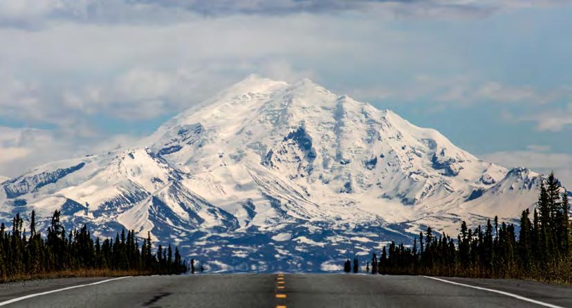
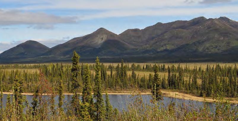
P. 5: Mount Drum (12,010’) rises on the east edge of the Copper River Valley. Drum is part of the Wrangell Mountains, or Kelt’aini, meaning The Ones That Control the Weather, to the Ahtna Athabascan people who are Indigenous to the Copper Valley. Photo by Jeremy Pataky.

Welcome!
Kennecott & McCarthy sit at the center of Alaska’s WrangellSt. Elias National Park and Preserve, the largest park in the country. The wild landscapes and fascinating history of the area are renowned. Located in the territory of the Ahtna Athabascan people who’ve inhabited the area since time immemorial, this national park was established not only to protect the land, but also to honor the traditions of people living within the park who depend on local resources.
The area is rich with superlative natural features and home to people with deep senses of place. Wrangell-St. Elias is contiguous with Kluane National Park in Yukon Territory, Glacier Bay National Park in Alaska, and British Columbia’s Tatshenshini-Alsek Provincial Park. Altogether, they comprise the largest protected wilderness on the planet, part of a 24-million-acre World Heritage Site.

ed by the Chugach National Forest to the south, the Alaska Range to the north, the Wrangell Mountains to the east, and the Talkeetna and Chugach mountains to the west. The Copper River, one of the continent’s major rivers, begins at the northern base of the Wrangells and flows 250 miles to the Gulf of Alaska near Cordova. Along with stunning mountains and glaciers, rivers and lakes, tundra and wetlands, you’ll find world class flightseeing, wild floats, great fishing, rich history, and good food. You’ll meet warm locals proud to call the place home and happy to share it.
Like all businesses in Kennecott-McCarthy, the visitors guide grew is locally grown. We’re glad to connect friends and neighbors with independent travelers from Alaska and beyond. I hope this resource leads you to memorable experiences and new friends. Safe and happy trails—see you in the Wrangells.
To reach Kennecott and McCarthy, travelers transit the Copper River Valley, a 20,649 square mile area in East Alaska. Also called the Copper River Basin, it’s bound-

 Jeremy Pataky Publisher
4
This page: Photo by Teresa Houze. Cover: Photo by David Gonzalez Rebollo, stock.adobe.com.


PHOTOGRAPHY
Corey Belt
Martin Capek
Scott Clendaniel
Stephens Harper
Dave Hollis
Teresa Houze
Mickey Kenny
Kristin Link
Luke McKinney
David Mitchell
Tenley Nelson
Jeremy Pataky
David Pastyka
Bryan Petrtyl
Victoria Rego
Jessie Sheldon
Jessica Speed
Nathaniel Wilder
ARTWORK & MAPS
Ian Gyori
Tamara Hamby
Jennifer Kosharek
Kristin Link
ADVERTISING
To advertise, email kmxy.guide@gmail.com
Find hard copies throughout the Copper Basin, Kennecott-McCarthy, Anchorage, Valdez, Tok, and beyond, and online in a digital edition, compliments of our advertising partners. Free guides are also available by mail order through our webstore with just a nominal shipping fee. For international orders, email.
No part of this publication may be used without written permission by the publisher. Every effort has been made to avoid errors, misspellings, and omissions. If, however, you spot an error, please accept our sincere apologies and notify us. Thank you.
KMXYvisitorsguide.com
5
Feedback & submissions welcome by mail at KMXY Visitors Guide 22B, PO Box MXY Glennallen AK 99588 or by email. Printed by Service Business Printing, Anchorage. © 2024 Overstory Consulting. All rights reserved. 10 Transportation 13 Recommended Audio 14 McCarthy Road 27 Arrival Logistics 28 McCarthy & Kennecott History 36 Emergency Contacts 37 Kenn·i/e/y·cott Spelling 40 Winter in McCarthy 42 Creeks & Rivers 46 Alaska’s Glacier Capital 50 Ice Science 52 Glennallen & the Copper Basin 63 Bear Safety 64 Nabesna Road & Tok Cutoff 70 Chitina & Kenny Lake 76 Copper Center 80 Valdez
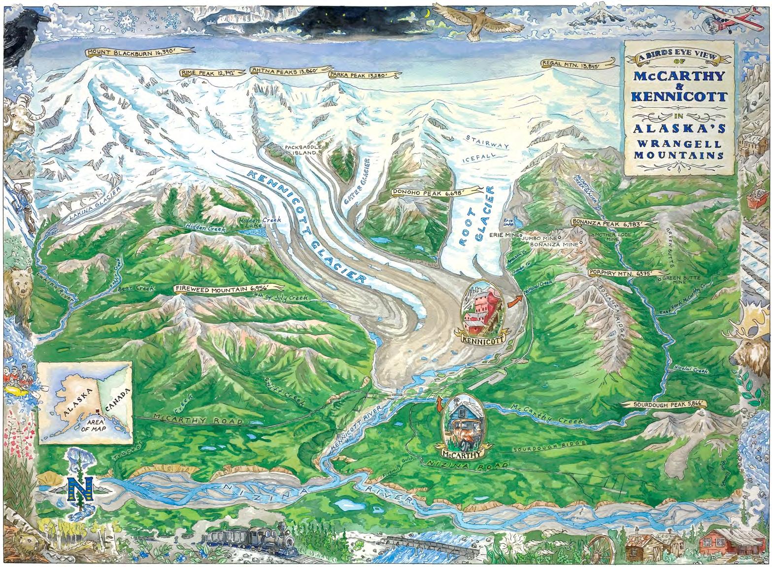
2024 Contents MAPS 5 Region 6 Kennicott Valley 15 McCarthy Road 23 McCarthy & Kennecott 53 Glennallen 66 Tok Cutoff & Nabesna 76 Copper Center 84 Southern Richardson
Base Camp Kennicott
Gateway to McCarthy & Wrangell-St. Elias

Camp or park at the road’s very end, as near as possible to the shuttle and, well, everything.
No, no, no: Worries, reservations, crowds, hook ups, hassle.
Oh, yes: Views, RVs, tents, cars, trailers, firewood, ebikes, adventure info & booking, rental teepees, late check-in, answers.


BaseCampKennicott.com

Anchorage Whittier Valdez Cordova McCarthy Kennecott Chitina Kenny Lake Copper Center Glennallen Mt. Sanford Mt. Drum Mt. Wrangell Mt. Blackburn Thompson Pass Palmer Eureka Prince William Sound Gulf of Alaska Seward Matanuska Glacier Sheep Mountain Wasilla How many miles to McCarthy? Anchorage Calgary Chitina Copper Center Fairbanks Haines Kenny Lake Key West Missoula Seattle Tok Valdez Whitehorse from 314 2,073 60 111 374 699 87 5,060 2,448 2,204 264 178 648
8
are available for sale.
9
Artwork by Ian Gyori, chef & co-owner of the Potato (p. 12), where prints
Stay Awhile
Make time to explore McCarthy & Kennecott

most accessible large glacier in Alaska · best flightseeing in North America captivating history · geologic wonders · largest national park · camping · lodging culinary adventure · backcountry access · rafting · glacial iceberg kayaking packrafting · live music · museum · educational programs · welcoming people


Photos by Jeremy Pataky

Good living in America’s largest national park


11
Planes, trains (well...

Drive
From Anchorage, drive north. Head east on the Glenn to Glennallen, then south on the Richardson toward Valdez, then east on the Edgerton to Chitina. Keep going, finishing on the McCarthy Road. Allow a minimum of 7 hours from Anchorage. More rental car companies have begun to allow rentals on the road, but check your company’s policy. See the McCarthy Road section for more info.
SHUTTLE
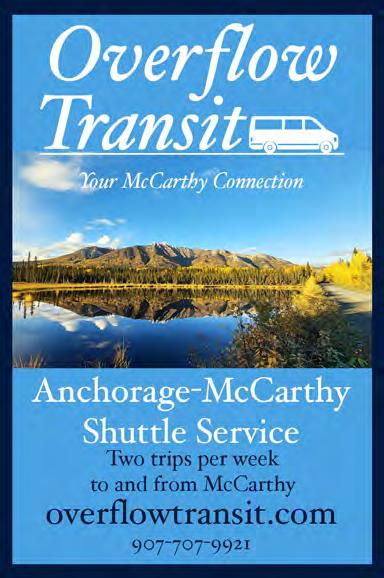
Multiple companies connect Anchorage, Glennallen, Chitina, and McCarthy via van. Also, some private tour companies include McCarthy on multiday van trips, like Get Up and Go and Great Land Adventures.

fly Wrangell Mountain Air (back) connects Chitina and McCarthy. Copper Valley Air Service (opposite) flies passengers and mail between Gulkana, just north of Glennallen, and McCarthy. Using Copper Valley and Reeve Air, it’s easy to fly between Anchorage and McCarthy with a transfer, or by combo ground/air. If you’re a private pilot, the world’s your oyster. McCarthy has a large strip, and the park features numerous bush strips, including some with public use cabins.
sweat Many have reached the Kennicott Valley on their own power. The most common method is bicycling, but competent trekkers have concluded wilderness trips here, as well.

1991
12 Daily Shuttle Service To McCarthy the heart of Wrangell-St. Elias National Park BnBs, campgrounds, hotels, and RV parks in Chitina, Kenny Lake, Copper Center, & Glennallen Save your tires, Enjoy the ride... kennicottshuttle.com 907-822-5292 Local, Knowledgeable, Safe Drivers We pick up fr om Since
once upon a time,) and automobiles You’ve got plenty of transportation options


Copper Valley Air Service (above) provides twice-weekly direct flights from Anchorage, Gulkana, May Creek, and McCarthy. Passengers ride on Monday and Thursday mail planes. Wrangell Mountain Air (back cover) offers daily scheduled flights between Chitina and McCarthy.


13 InteriorAlaskaBusLine.com Call 800-770-6652 or 907-883-0207 or email akbus2@aptalaska.net Year-round transportation every Monday, Wednesday, and Friday Affordable routes connecting both Anchorage & Fairbanks with Tok. Drop-offs and pick-ups along the Alaska, Glenn, & Tok Cutoff Highways.


14 Coffee, Breakfast, Lunch, Dinner Burritos · Wild Alaska Salmon · Hand-cut Curly Fries Burgers · Pizza · Espresso · Beer, Wine, Cider theroadsidepotatohead.com Two locations. No excuses. downtown McCarthy Labor Day weekend——Sept. 15 907-554-4504 Valdez · 255 N. Harbor Dr. May 1—When the time comes 907-835-3058
Recommended Listening

Mostwho visit McCarthy spend a good amount of time on the road, so here are some listening recommendations to enrich your time in the Wrangells. Cell coverage varies. Do not rely on streaming while you drive; download when you can and listen for miles.
out here McCarthy local Erin McKinstry, a freelance journalist and audio producer, tells stories of life in rural Alaska in her podcast, Out Here. The first season explores the McCarthy area, delving into off-grid living, bucking the nine-to-five lifestyle, raising kids in the wilderness, subsistence living (or not), and living in an individualistic community short on governance. Oh yeah—there’s also a bear story or two. Think of it like a book with an intro and seven chapters. All of the episodes are derived from personal experience and interviews with 18 area residents.
Good chance you’ll meet some of them in McCarthy if you talk to strangers. Subscribe wherever you get podcasts. outherepodcast.com


End
of the Road This podcast explores the remote reaches of Alaska from those who have lived it, produced by the Wrangell Mountains Center (pg. 31). The show captures stories and reflections on nature, place, history, and more in the Wrangells. Subscribe wherever you get podcasts. wrangells.org/end-ofthe-road
nps rOAD tours
The National Park Service produced audio tours for both the McCarthy and Nabesna Roads. Listen and learn about geology, history, flora, and fauna. Download the audio (and transcription if you want it, too) for free or ask for CDs at the Wrangell-St. Elias National Park and Preserve Visitor Center in Copper Center, or the Chitina or Slana Ranger Stations. nps.gov/wrst/learn/ photosmultimedia/audio-tours.htm
15
Top: Wrangell Mountains Center (p. 30) executive director Jon Erdman interviews WMC co-founder and board member Sally Gibert inside the Old Hardware Store in downtown McCarthy; photo by Jessie Sheldon. KMXY
the Road to McCarthy

Say yes Few roads are as storied as the McCarthy Road, one of only two that enter Wrangell-St. Elias National Park and Preserve. It offers unrivaled scenery, vast and varied wilderness, independent and neighborly folk, and adventure. It skirts the base of the Wrangells, gaining about 1,000 feet between Chitina (500 feet) and its end near McCarthy. The road terminates in the center of the 13.2-million acre Wrangell-St. Elias National Park and Preserve, but the road corridor threads lands owned by the state, Ahtna Native Corp., and individuals. About 40 of the McCarthy Road’s 59 miles are gravel. It’s maintained by the state, not the National Park Service.
history The road’s 59 miles connect the Copper and Kennicott Rivers, roughly following part of the historic 196-mile-long Copper River and Northwestern Railway (CRNW) railroad grade. Constructed between 1908 and 1911 through a herculean effort comparable to the construction of the Alcan Highway or the Trans-Alaska Oil Pipeline,
the CRNW railway ran from Kennecott to O’Brien Creek outside Chitina. It departed the contemporary road system from there, following the Copper downstream all the way to the port of Cordova, on Prince William Sound. The last train to make that journey arrived there on November 11, 1938.
After the railway was abandoned, most of its rails and ties were eventually removed. The corridor was turned over to the State of Alaska, which placed some culverts and created a road in the 1960s. In 1971, a new bridge was constructed over the Copper River and the railbed was covered with gravel, creating the McCarthy Road. It has been dramatically improved since then; 18 miles were even lightly paved in 2014. Its reputation has also improved, though not on pace with its condition.
the experience Services are limited and cell reception varies. While the road is usually in good shape now, the weather, maintenance schedules, use, and more affect conditions. Also, the
16
Jeremy Pataky
better a road gets, the more reckless bad drivers like to get, right? Shoulders in places are soft, and ought not be trusted. The main variable that will hedge your bets on a hassle-free trip is your speed—take it slow, especially around the curves. Those who go slow see more, including friendly faces. Those who push it get flat tires and close calls. Mind oncoming vehicles and show respect for fellow drivers. Allow two hours to get from Chitina to the end of the road under decent conditions. More when it’s rough. Slow and steady wins the race, but it’s not a race. Make sure your spare and jack are functional, and drive in a way that minimizes the chance that you’ll need them. Increasingly rarely, railroad spikes still churn up in the gravel, especially when the road gets graded. Hordes of spikes have been collected over the years. Most travelers experience the road without incident. Everything from RVs, sedans, and motorcycles to large box trucks and heavy equipment are common on the road in summer. You will not see any motorcoaches,
though—the largest tour vehicles on the road are vans. Your fellow travelers are independent-minded people who’ve done themselves well by getting off the beaten track.
Enjoy the drive. It’s one of the last best roads in America and leads to a stunning place of natural, historical, and cultural import. Welcome, enjoy, and stay a while. KMXY

a note on Highway Names
Most Alaskans know their highways by proper names, not numbers. If you ask a local how to get to Highway 10, they might not know. Try “Where’s the Edgerton?” and you’ll be understood.


“Glenn Highway” from Anchorage to Glennallen; “Tok Cutoff” from Gakona to Tok
“Richardson Highway”
“Denali
17
Long Lake Kennecott McCarthy Silver Lake Currant Ridge Cabins Chokosna Trading Post Strelna ChitinaRiver KuskulanaRiver Gilah i n a R i rev LakinaRive r CrystallineHills Copp er River McCarthy Cabins End of Road Detail: Public Phone McCarthy B&B Glacier View Grill & Campground Kennicott River Lodge Base Camp Kennicott NPS kiosk (closed) McCarthy River Tours, ice cream, lodging Fireweed Mt. Lodge to Camp McCarthy
Chitina
Highway” “Edgerton Highway”
McCarthy Road by the Mile

Highest mileposts are closest to McCarthy. Directions assume one drives west to east.
Mile
0 Chitina Wayside
: This paved pull-out, with vault toilets and exhibit panels, is the start of the McCarthy Road. Beyond, the road goes through a narrow gap known locally as the “railroad cut.” It was a tunnel, later altered into an open road cut.
0.4-1 Small pullouts with views of the Copper R. and Chitina R. confluence. The Copper is the only waterway that cuts through the Chugach Mountains that arc across southcentral Alaska for over 200 miles. However, the Cop-
per is actually smaller than the Chitina at the confluence. The Chitina does carry more water year-round, though it’s considered the Copper’s tributary. Even though the Chitina drains a smaller area than the Copper, it gets more runoff due to greater precipitation in its watershed. The entire Copper River watershed drains about 24,000 square miles. Much of this area lies within Wrangell-St. Elias National Park and Preserve. About 3,500 square miles, or 17% of the drainage basin, is covered by glaciers. Because of this influence, high water in the Copper typically occurs not during the snowmelt of spring, but during summer
 Jeremy Pataky
Jeremy Pataky
Jeremy Pataky


19 Summer
CONSTRUCTION ALASKA means...
surprise
way,
511
For more
dot.alaska.gov/construction Edgerton Highway Local
of Transportation
It is
Alaska
of Transportation
Public
no one shall be subject to discrimination on the basis of race, color, national origin, sex, age,
disability. MP 24-29 Resurfacing CMY Blending the charm of camping with a cozy touch of home. • Solar lights • Games • Campfire circle • Nature trail • Privacy • Amazing views Advanced booking required: 907.205.0907 or CampMXY.com • 12’x14’ canvas tents • Luxury bedding • Cedar decks • Pavilion • Showers
Great location
ROAD
Avoid a
along the
visit 511.alaska.gov
Alaska mobile app for traffic delays.
project information visit
Area Project Alaska Department
& Public Facilities
the policy of the
Department
and
Facilities (DOT&PF) that
or
•
hot spells that cause rapid ice melt.
1.5 As you drive over the Copper River, see the confluence of the Copper and Chitina downstream. After the bridge, the road becomes gravel. The large snowy mountain visible to the north is volcanic Mount Drum (12,010’), part of the Wrangell Mountains. The Copper and Chitina carry a great deal of suspended sediment, but very little dissolved sediment—they’re dirty, but not polluted. Millions of tons of natural sediment, mostly silt and clay, flow downstream each year. Muddy waters preclude permanent habitation for most fish, but do accommodate migrating full-grown fish en route to clear-water spawning beds and juveniles running down to the sea each year. The muddy waters also allow state residents to successfully salmon fish with dipnets and fishwheels, which don’t work as well in clear water.
1.6 Immediately after the bridge on the right side of the road is the Copper River Campground. This primitive campground has a dozen sites, picnic tables, fire pits, and vault toilets. On the left side side of the road is the Copper River and the Kotsina River delta. The NPS has an easement here where you can access and view the Copper River. It can be a decent place to see Alaskans harvesting salmon when the fish run. Note the bright deposits of volcanic material in the Kotsina River bluffs.
2-2.5 See the Kotsina, a moderate tributary of the Copper River, fed by glaciers draining southward from Mt. Wrangell. Bright debris deposited by

Above: The wooden Gilahina trestle was originally 890 feet long and 90 feet high. It required one-half million board feet of timber and was completed in eight days in the winter of 1911. Due to the rugged landscape, over 15% of the entire railway was built on trestles like this. Photo by Dave Hollis.
20

volcanic flows are exposed south of the road and in the Kotsina River bluffs a mile to the north.
5-5.4 Rocks exposed on the left side of the road are basalt and greenstone of the Nicolai Greenstone rock unit, common in the Wrangell Mountains and the source of copper mined near Kennecott. As you continue, you’ll see limestone also exposed on the north side of the road. Several small pullouts offer nice views of the Chitina River and Chugach Mountains to the south. The glacier-fed Chitina is a classic example of a braided river. Streams throughout the world exhibit three basic channel patterns: straight, which is uncommon in large streams; meandering, which consists of many curves and bends; and braided channels. The braided channel pattern tends to develop in rivers that carry a lot of sand and gravel, and have fairly steep slopes and frequent fluctuations in water level. Many braided rivers flow in this region. Braided rivers are characterized by dividing and re-uniting channels and
by numerous islands and gravel bars. In the area visible here, the Chitina drops ~13 feet per mile; steep for such a large stream. Glaciers load the stream with sediment ranging from fine clay to boulders. Weather patterns cause flow variations—the river rises during warm and/or wet weather and drops during cold and/or dry weather. Consequently, much of the sediment being transported to the sea is temporarily stored as islands or bars of gravel, sand, and mud along the Chitina. If you happen to view the river after several hot days, most of the islands and bars will be flooded.
10 Strelna Volunteer Fire Department. Nearby, a short trail leads to Strelna Lake, with silver salmon, kokanee, and rainbow trout.
11 Silver Lake. Rainbow trout.
12 Sculpin Lake. Rainbow trout, silver salmon, and kokanee.
17 Kuskulana Bridge spans a 238’ gorge. This is a one-lane bridge. Watch for oncoming traffic. The 600’ steel
21
A black bear cub crosses McCarthy Road in spring without first looking both ways. Photo by Jeremy Pataky.

Right: Alaska has about 1,000 bridges on public roads and streets excluding federally owned ones. The State of Alaska Department of Transportation systematicly inspects these bridges. A crew last summer evaluated the condition and functionality of the Kuskulana Bridge to detect any possible problems. Note the catwalk below the driving deck. Photo by Jeremy Pataky
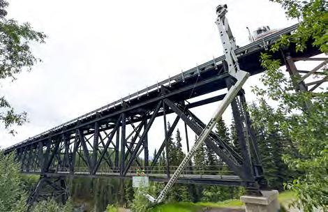
bridge was redecked in 1988 and guard rails were installed. Vault toilets on its east side were provided by NPS in 2007. The Kuskulana’s muddy water comes from glaciers on the southern and western slopes of Mt. Blackburn.
20-21 Shallow permafrost affects vegetation and causes poor drainage. This is a good place to consider the challenge of road construction and maintenance in areas of permafrost, muskeg, and swamps.
26 Views of Mt. Blackburn to the north, weather permitting.

Top: A spectacular achievement, the Kuskulana Bridge was constructed during a period of brutal cold in the winter of 1910. It is the only railroad bridge in this area constructed of steel girders that span a canyon, as opposed to those where timber pilings were driven into streambeds. The bridge is supported primarily by the metamorphic bedrock of the inner Kuskulana River gorge rather than the thick layer of glacial gravels near the surface. Bottom: McCarthy Road crosses the Kuskulana River gorge. The water is very silty during summer. Photo by David Mitchell.
22
Vladislav


23 907.205.0907 or McCarthy-Cabins.com Three cozy cabins on separate properties, each with: Kitchenette • Linens • Shower house • Outhouse • Privacy Mile 56.5 McCarthy Road | Reservations required McCarthy Cabins McCarthy Cabins A true Alaska experience with incredible comfort and charm • Unbeatable location in downtown McCarthy • Two units with private bathrooms & showers • Modern amenities include heat, electricity, wi , and a full kitchen. Your home away from home in McCarthy, Alaska mccarthyguesthouse.com • 907-554-1066


26.5-8 Chokosna Trading Post and Chokosna River. Clear waters support salmon spawning beds. (Ad above.)
29 Gilahina River & Gilahina Trestle Wayside. The impressive ruin of a railroad trestle looms over the road. Near its base, you’ll cross a small bridge built in 1990 that spans the Gilahina River, which runs clear, like the Chokosna, in-

This new 1800 sq. foot craftsman home offers all the comforts with spectacular views. 3 bedrooms, loft, 2 baths, full kitchen, large living & dining rooms, sunroom, & deck. Accommodates 10. Short walk to downtown McCarthy.


stead of silty. Vault toilets courtesy of NPS.
34.7 Crystalline Hills Trail, an easy 2.5-mile loop north of the road. The hills are composed mostly of gneiss and gabbro, with some light colored marble on some lower slopes. Look for Dall sheep high up there.
44.5 Lakina River (LACK-in-awe) bridge. Packrafters occassionally take out of the river here and hitch rides.
45.2-47.5 Three-mile-long Long Lake is very important to Copper River salmon. Each year, ~18,000 sockeye salmon muscle up the silty Copper and Chitina Rivers and spawn here. They enter the lake as late as September and spawn through April. Glacial till and gravels deposited by ancient glaciers and streams
24
Enjoy Wrangell-St. Elias National Park from your own home base on the vehicle-friendly side of the footbridge. FIREWEEDMTNLODGE.COM
Donaho House 907·242·3219 See AirBnB or Vrbo:
Trading Post Organic Alaskan Pour Over Coffee Mile 26.5 McCarthy Road
Chokosna
Q: All that rock and rubble out there must be mine tailings, right?
A: Nope! It’s a rock-covered glacier! Get the scoop on page 50.
25 Swimming Hole Kennico t t Rive r ClearCreek McCarthyCr. Tony Zak’s Blackburn Cabins Mail plane Wagon Road McCarthy Airstrip Toe of the Kennicott Glacier McCarthy Fire Dept. Footbridge Shuttle Stop Kennecott Cemetery Base Camp Kennicott Kennicott-Mt. Blackburn Bed & Breakfast Potato Tony Zak’s Museum NizinaRoad WMA planes Ultima Thule building downtown Cemetery EMS General Store S i l k S t o c kgni woR Shuttle Stop ShortcutTrail Ball Field Museum Golden Saloon Ma Johnson’s Hotel Old Hardware Store Wrangell Mountains Center Porphyry Place Kennecott Detail Downtown McCarthy tinycabins McCarthy Guesthouse St-Elias GuidesAlpine & Copper Oar Lancaster’s McCarthy Center Stores - grocery & liquor The Potato Wrangell Mountain Air Mill Building Meatza Wagon Kennicott Wilderness Guides Kennicott Glacier Lodge Rec Hall St-Elias Alpine Guides National Creek NPS Visitors Center McCarthy River Tours & Out tters Salmon & Bear Restaurant
fuel up & gear up at
Copper Town Shuttle hub picnic tables & space to hang Italian sodas & espresso · ice cream groceries & sundries · produce · outdoor gear beer, wine, & liquor · mosquito repellent & sunscreen
Kimmie the Lodge Dog welcomes
you.


From trail mix to housemade pastries, find essentials, gifts, and Alaska swag to make your journey unforgettable!

McCarthy
Center Stores
blanket the slopes around the lake. Large pullout on east end of the lake.
47.9 View remnants of a CRNW trestle across inflow streams.
55 Forestry pullout. Toilets.
56.5 McCarthy Cabins. (p. 21) Turn south.
56.7 Currant Ridge Cabins.
58-58.4 The Kennicott Glacier and River can be viewed from turnouts. Glacier ice is blanketed by rock, ranging from large boulders to very fine glacial flour. The Kennicott. is only five miles long and runs from the glacier down to the Nizina River. Bluffs along the Kennicott indicate down-cutting by stream erosion after the glacier melted back from its earlier size. From here you can see how the river valley gets progressively deeper downstream. The river drops 250+ feet in its short run from the glacier to the Nizina. At that confluence, the Kennicott’s erosional canyon is over 350 feet deep; ten miles further downstream, the Nizina is entrenched 600+ feet at the Chitina confluence.

59 Fireweed Mountain Lodge (p. 22) on the north side of the road. Also: Glacier View Campground and Glacier View Grill. (p. 1)
59.25 As the Glacier Melts Cafe / McCarthy River Tours & Outfitters / Kennicott River Lodge office. Ice cream, espresso, gear rentals, day and multi-day trip booking, lodging (p. 1).
58.5 Shuttered NPS kiosk. Day-only parking, toilet, trailhead.
58.6 Camp McCarthy (p. 17), McCarthy B&B, and NPS staff housing, turnoff. Visitors should not turn here without reservations at one of the local westside residences or businesses. If your phone or GPS says to turn here to reach McCarthy, do not fall for it—the phones are confused. The vast majority of visitors want to go straight to the road’s end.
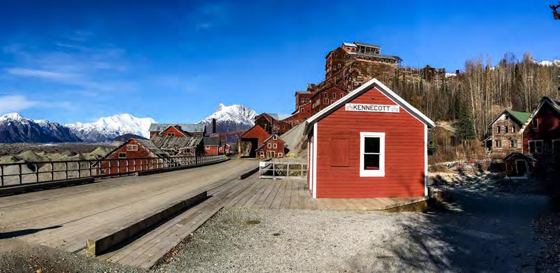
59.4 Base Camp Kennicott (p. 4) and road’s end. Car camping and parking. Mill tour and day and multi-day trip reservations with St. Elias Alpine Guides and Copper Oar (inside front cover). After-hours pay station makes late arrival easy.
Top: A lone car with a rooftop tent camps on the banks of the Kennicott River as viewed from the footbridge. Acrylic painting by Jennifer Kosharek. Find her in McCarthy at Mountain Arts, and on Instagram at @kosharekart.
27
KMXY


28

Made
it. Now what?
Whatever your plan—car camp, stay in a lodge or rental cabin, park and head for the hills, or visit friends who live in McCarthy— arrival is straightforward and easy. Visitors can’t drive their own vehicles into McCarthy town, and don’t need a vehicle to experience the place—open vehicle access ends at the Kennicott River, where a footbridge allows pedestrian access. Daytime shuttles to McCarthy and Kennecott are readily available; schedule and pricing can vary. From the bridge, McCarthy is about one mile by shuttle or human power, and Kennecott is about five miles from the bridge. Drive-up lodging is available by reservation at establishments on the west side of the Kennicott River, as well as convenient just-show-up car camping with easy access to town.
If you are staying on the east (or far) side of the Kennicott River, just park at one of the lots at the end of the McCarthy Road and scoot across the bridge to your lodgings. Some lodging options, made with advance reservations, include their own private
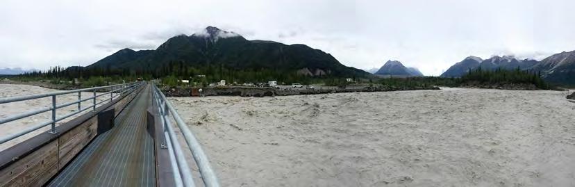
The foodbridge spans the Kennicott River, which flows from the glacial lake just to the north. The lake grows larger each year as the Kennicott Glacier retreats further and further. In the distance, Kennecott mill town shows in the boreal forest at the base of the mountain slopes. The seven thousand foot Stairway Icefall, largest icefall in the world outside of the Himalayas and source of the Root Glacier, is visible to the right of Donoho Peak.
Photo by Scott Clendaniel.
pick up service. Others ask guests to take a public shuttle or walk to check in.
The photo above shows Base Camp Kennicott (p. 4) and the Kennicott River footbridge. Just out of frame to the left is additional camping, food service, and indoor lodging offered by Glacier View Campground, Grill, and Kennicott River Lodge (p. 1).
A walk across the footbridge that spans the Kennicott River connects the west side parking and camping areas with shuttles just out of view to the right. The McCarthy Area Council (p. 31; kick them a donation if you appreciate the hand) nonprofit provides and maintains handcarts to help haul luggage or gear back and forth across the bridge. Please don’t drag the carts away from the bridge. Welcome to the heart of the Wrangells!
29
McCarthy & Kennecott

HIstory in brief
Archaeological evidence indicates that people entered the Wrangell Mountains about 1000 AD. The Ahtna people settled along the Copper River. A few Upper Tanana speakers settled along the Nabesna and Chisana Rivers. The Eyak people settled near the mouth of the Copper River on the Gulf of Alaska. Along the coast, the Tlingit people dispersed, with some settling at Yakutat Bay.
The first Europeans in the area were Russian explorers and traders. Vitus Bering landed in the area in 1741. Fur traders followed. A Russian trading post was established in 1793 on Hinchinbrook Island near the mouth of the Copper River. A competing post was established in 1796 at Yakutat Bay. Reports that the Native people used pure copper tools inspired early Russian forays up the lower Copper River. The upper river was not
reached by outsiders until 1819, when the Copper Fort trading post was established near Taral (downstream of Chitina). The Ahtna repelled Russian exploration, killing a party that departed Taral in 1848 with the intention of reaching the Yukon River.
The U.S. acquired Alaska from Russia in 1867, but it took the discovery of gold in the Yukon Territory in the 1880s to spur interest in the Wrangell Mountains region. George Holt was the first American known to have explored the lower Copper River, in 1882. In 1884, John Bremner prospected the lower river. That same year, a U.S. Army party led by Lieutenant William S. Abercrombie attempted to explore the lower river, and found a passage to the country’s interior over a glacier at Valdez Arm. In 1885, Lieutenant Henry Allen fully explored the Copper and Chitina Rivers, eventually crossing the Alaska Range to
30
Pecold
Railroad memorabilia
Bonanza Mine diorama
Historic photos & panoramas
3D model of historic McCarthy


Open Memorial Day through Labor Day. Free entry. Donations or sales appreciated.
the Yukon River system and eventually reaching the Bering Sea.
While exploring the Chitina River region, Allen sought out Chief Nicolai, chief of the Copper River Ahtna, at his hunting camp at Dan Creek. Allen and his men were at risk of starvation, and Nicolai rescued them by sharing food and supplies. Allen also saw the Ahtna’s copper knives and tools, and some believe that Nicolai showed Allen a source of the native copper.
In 1899, Abercrombie blazed a new trail from Valdez through the Chugach Mountains at Thompson Pass and onward. For the first time, the Copper River headwaters were relatively easy to access. Abercrombie sent Oscar Rohn up the Chitina River, as well. Rohn encountered prospector James McCarthy and
mccarthykennicotthistoricalmuseum.com


31
Walking tours,
more
sale
books, merch, &
for
Research materials and reading library
17SilkStockingRow.com An historic family
cottage in


Welcome! If you enjoy McCarthy and want to contribute to its vitality, please donate to McCarthy Area Council, a volunteer-run 501(c)(3) working to improve life for locals and visitors. On your behalf, MAC:
• administers State of Alaska funds
• engages agencies and partners
• maintains five public outhouses (and more)


• facilitates important community conversations. Scan


named a creek after him in exchange for supplies. He also named the Kennicott Glacier after another explorer and described the valley in detail. His report spurred a great deal of subsequent geological surveys in the region. A year after his 1899 report, prospectors Clarence Warner and Jack Smith discovered Kennecott’s uber-rich Bonanza copper deposit.
The prospectors sold their claims to 28-year old Stephen Birch, a mining engineer from New York sent to Alaska to look for investment opportunities for the wealthy Havermayer family. Birch, confident that money could be made, set out to gain clear title to the claims and obtain financial backing from the Guggenheims and J.P. Morgan.
Construction of the 196-mile Cop-
per River and Northwestern Railroad (jokingly called the Can’t Run and Never Will ) from Kennecott to Cordova began in 1907. The railroad would bring supplies in to the mines and take ore out.
The construction challenge was massive. The railroad had to span rivers, mountains, and active glaciers on its way to Kennecott from the coast. Construction of the railroad was awarded to Michael J. “Big Mike” Heney who had completed the famous Yukon and White Pass Railroad from Skagway. This fierce Irishman ensured the first trains rolled into Kennecott four years later. In the meantime, Stephen Birch had been busy. Despite the inhospitable terrain, he had managed to transport enough equipment into Kennecott to begin mining.
32
visit
website to donate
you! mxycouncil.org
the QR or
our
online or to learn where to mail a check. Thank
Wrangell Mountains Center is a place-based nonprofi t connecting people with wildlands through artistic expression, scientific exploration, and local culture in the Wrangell Mountains.


Check out End of the Road, our podcast exploring the remote reaches of Alaska and beyond with stories and reflections on nature and place.

Listen at wrangells.org/end-of-the-road or wherever you get podcasts.

Stop by our headquarters in downtown McCarthy to learn more about our historic building’s 115 year history.
Through lectures and storytelling, artist talks and workshops, community photography and field sketching groups, and more, our programs connect people with wildlands.

See the calendar of upcoming events and programs.
wrangells.org
Mountains Center McCarthy, Alaska
Wrangell


porphyry.press The country’s most remote book publishing company is this award-winning, McCarthy, Alaska-based micropress. Get your books straight from the source. Available all over the region and online.
Meatza Wagon


When the train finally arrived, he loaded it with copper ore valued at $250,000 in those days’ dollars. With the key link complete, production ramped up.
Kennecott was a company town. Most miners lived in company housing and everything revolved around mining operations. The town was “dry” and miners were not allowed to bring their families. Kennecott work was long, hard, and dangerous. In the end, they worked five mines near Kennecott, transporting all the ore to the mill town back in “camp” for processing. At the operation’s peak, about six hundred men worked in the combined mines and mill town, earning higher pay than they might have in the Lower 48. Kennecott workers mined and concentrated at least $200 million worth of ore.
Nearby, the town of Shushana Junction began developing. This small town eventually changed its name to McCarthy and became the site of a turnaround station for the train. McCarthy was quite a miner and railroader town, with all the entertainment a young man on the frontier might want. Restaurants, hotels, saloons, pool halls, a dress shop, shoe shop, garage, hardware store, and red light district all served more than 800 people in the area. Kennecott and McCarthy coexisted for the 27 years that Kennecott operated. Residents still maintain traditions from those days, such as the 4th of July ball game. By 1938, after selling a staggering $200 million in ore, the rich copper deposits were depleted and the mines of Kennecott—and thus the railroad—
35 meatzawagon.com original recipes & glacier views OPEN 11 AM-4 PM CLOSED MONDAYS
great food in downtown Kennicott The The
sale. Check out our website and @meatzawagon on Instagram for info. Help us celebrate our 10th season in business!
Meatza Wagon is turnkey and for

ceased operations. The mill town was abandoned along with almost everything in it. Dishes were left on tables, medical records were left in the hospital, and mining equipment was abandoned. What happened in this remote valley in the wake of that early 20th century era, between the closing of the mines and the coming of the National Park Service in the early 1980s? For years, several groups attempted to resume mining operations in the area, but the high transportation cost from such a remote area proved too much.
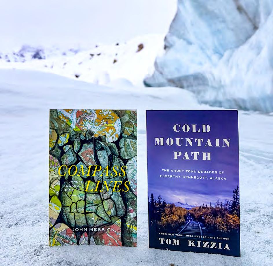
Life around the area became quiet but interesting until the 1970s, when tourism began to develop. The New York Times bestselling author Tom Kizzia wrote the must-read book, Cold Mountain Path, on those “lost decades” of McCarthy and Kennecott. The award-winning book was published locally by Porphyry Press (p. 32), a book publishing company based in McCarthy and the most remote one in the country. (Full disclosure—Porphyry Press was founded by the publisher of this guide.)
The national park era
Though it would take decades to come to fruition, the seeds leading to the creation of Wrangell-St. Elias National Park were sown soon after the last train left the valley. After a flight over the area in 1938, Ernest Gruening, Director of U.S. Territories at the time and later Alaska’s governor and a U.S. Senator, recommended the area as a national park or monument. In a memo to the Secretary of the Interior, he wrote: “The region is superlative in its scenic beauty and measures up fully and beyond the requirements for its establishment as a National Monument and later as a National Park. It is my personal view that from the standpoint of scenic beauty, it is the finest region in Alaska. I have traveled through Switzerland extensively, have flown over the Andes, and am familiar with the Valley of Mexico and with other parts of Alaska. It is my unqualified view that this is the finest scenery that I have ever been privileged to see.”
In 1978, President Jimmy Carter
36
A hiker approaches the National Creek bridge south of the Mill Building on a bluebird fall day, setting out through Kennecott for the Root Glacier, with views of Mount Blackburn and Donoho Peak in the distance.
declared the area a National Monument because of its cultural and scientific significance. When Congress passed the Alaska National Interest Lands Conservation Act in 1980, the area became part of the 13.2-million acre Wrangell St. Elias National Park, the largest in the U.S. Wrangell-St. Elias is one of four contiguous conservation units spanning 24 million acres that have been recognized by the United Nations as an international World Heritage Site. The original designation included Wrangell-St. Elias and Kluane National Park Reserve in Canada’s Yukon Territory. In 1993, both Glacier Bay National Park and Tatshenshini-Alsek Provincial Park in British Columbia were added to that designation. Altogether, it is the largest protected area in the world.
Although Wrangell-St. Elias National Park was established in 1980, the National Park Service did not acquire the buildings and lands of the Kennecott Mines National Historic Landmark until June of 1998. It was all private property prior to that moment. Today, the
mill site is a patchwork of public and private property. Enjoy this incredible place. Learn about the history, hike on the Root Glacier, float a glacial river, take a multi-day backcountry trip, go flightseeing, visit the museum, attend a ranger talk, eat out, relax, and take in the views.
McCarthy & Kennecott Now Tourism fuels the majority of the local economy. Subsistence activities are also important for many year-round permanent residents. People from all over the world visit the area each year to explore Kennecott and experience some of the most pristine wilderness left in the world. Since Kennecott became part of the park, some aspects of the bygone company town days have returned. By no means a pure agency outpost, the site includes private property, private business, and local residents. Though the bordellos are gone and the population is smaller than the old days, McCarthy is still the social hub. The McCarthy Road provides access, roughly following the old rail bed from Chitina to McCarthy. KMXY
37
Jeremy Pataky
Dial 911 to Report Any Emergency

FIRE · 907-554-2102 · Kennicott-McCarthy Volunteer Fire Department
Fire is our biggest community-wide threat. Please do not leave camp res unattended and extinguish them fully with water. Stay informed about burn bans at AKFireInfo.com or 907-822-TOOL.
MEDICAL · 907-554-1240 · McCarthy Emergency Services
Injuries are o en preventable. Our local, all-volunteer re and EMS resources are limited. McCarthy-Kennicott is far from advanced care. Be extra careful during your visit, and don’t drink and drive.
SEARCH & RESCUE · Is someone in the backcountry missing or overdue? · 907-683-2276 · National Park Service.
LAW ENFORCEMENT
· Feel unsafe or want to report crime? Call 911. Alaska State Troopers provide law enforcement. McCarthy may seem like the Wild West, but illegal activity here is not ignored.
MENTAL HEALTH · Free, con dential support for those experiencing a mental health crisis is available by calling 988, the Suicide & Crisis Lifeline.
SEXUAL ASSAULT · 907-835-2999, Advocates for Victims of Violence Did you experience domestic violence and/or sexual assault? Call and talk with advocates for con dential advocacy services.


Sponsors: Wrangell Mountains Center, McCarthy Area Council, Advocates for Victims of Violence, McCarthy Emergency Services, Kennicott-McCarthy Volunteer Fire Department, and Kennecott-McCarthy Visitors Guide.


911 should work even on phones without service. Other local response options are below.
Wrangell Mountains Center McCarthy Alaska Kennecott-McCarthy Visitors Guide 2018 Chitina Copper Center Glennallen Kenny Lake Kennecott McCarthy Valdez KMXYvisitorsguide.com
a note about spelling
The mining company was named after the Kennicott Glacier. The valley and river both share that i spelling. The geologist who left his name on those land features was spelled with an i.
No one really knows why Kennecott Copper Corporation ended up with a spelling that differed from its namesake. Most say it was a clerical error. The company’s founder, Stephen Birch, was even said to have spelled it Kennycott, with a y. Whatever the case, after the mines closed in 1938, many references to the area included the “i” spelling of Kennicott to distinguish what remained from the departed Kennecott Copper Corporation. Today, Kennecott Mines National Historic Landmark encom-
passes not only the mill site, but also the surrounding land and mining claims that formed the foundation for the Kennecott Copper Corporation, later the Kennecott Minerals Company.
In general, Kennecott tends to signify historic features and the settlement. Kennicott most often indicates natural features. Debates and discrepancies around spelling continue to this day. This very guide almost changes its own spelling annually and suffers under the implications of adopting the e versus i spellings (not to mention the question of whether or not to use a nonpossessive or possesive plural s in Visitors/Visitors’. Most of the rather significant mountains are still unnamed, around here... maybe it stands to reason that the scant inhabited spots can’t agree on labels, still.) KMXY
McCarthy-Kennicott Community Church

39
Kenn · i/e/y · cott
invites you to worship with us Find us on the “island” near the footbridge Sundays at 11 AM “God loves you — He really does!”


Wrangell-St. Elias National Park offers cultural, historical, and natural delights. Counterclockwise from top: 1. Late sun spills past Mount Blackburn and across the Kennicott Valley to the mill building.
Photo by Luke McKinney. 2. Artist notebook excerpt by Jennifer Kosharek. 3. The wing and strut of a Wrangell Mountain Air (back cover) bush plane frames a view of Mount St. Elias from an Icy Bay beach.
by Stephens Harper. 4. Guests enjoy a meal with a view from the deck of Kennicott Glacier Lodge (inside back cover).

41
Photo
Winter in McCarthy

McCarthy is very quiet during the long winter. Businesses close after brief 100 day seasons. Most seasonal employees and summer residents depart. There’s usually 30 or 40 people claiming McCarthy as their year-round residence. It’s common for many to leave for a month or two or three to travel internationally, work elsewhere, or visit family or friends during the depths of winter.
Come fall, daylengths start drastically shortening into brilliant night skies, winter storms, and occasional aurora. Winter road maintenance is not guaranteed and services are nonexistent. Snowmachines (a.k.a. snowmobiles) and skis replace automobiles for local travel, and the mail plane dons skis for twice-weekly, weather-dependent deliveries.
Bears den up for hibernation by around Thanksgiving in late November, and snowshoe hairs and ptarmigan enter their white winter phases. Even in sub-
zero temperatures, liquid water can ooze from the earth and freeze into hazardous ice on the road, growing into “road glaciers” that can be difficult to cross. Year-round residents prepare for stints of -40 degree cold, or worse—the lowest temperature officially recorded here was -57 F, recorded on November 11, 1972. Kennecott is often much warmer than McCarthy.

While McCarthy gets quite a bit less snowfall than, say, Anchorage, the temperatures are colder, so the snow tends to accumulate. Worse than the cold, though, can be the occasional winter thaw that turns trails to slush while exacerbating other issues.
For many who experience it, winter here, with its sublime beauties and challenges, solitude and community, wood heat and slow pace, is a favorite time of year. KMXY

Opposite: Mount Blackburn basks in alpenglow before sunrise one Christmas morning, as seen from Visitors Guide headquarters.
Photo by Jeremy Pataky. Top row: Winter sketches by local artist Kristin Link capture scenes from her home on the Nizina River outside McCarthy. Right: Fox tracks in otherwise undisturbed snow on the frozen Kennicott Glacier lake point toward the fading light during a long February 2nd winter sunset. Below: Drawings of chickadees by Kristin Link. They are common winter birds, and she says, “I am impressed by how active they are all winter, even in very cold temps. They can remember thousands of hiding places for food.... They turn into little fluff balls in the cold [bottom sketch].” Link’s work on this page was originally published by Copper River Record, the paper out of Glennallen. Follow Kristin on Instagram: @linkkristin


43
Creeks & Rivers
Two kinds of streams flow in the area. McCarthy Creek and the Kennicott River represent one type; much of their water comes from melting glacier ice. They carry a lot of silt and “rock flour” as a result. The other type consists of clearwater streams originating from snow melt or springs. Examples include Clear Creek, National Creek, Bonanza Creek, and Jumbo Creek. They run clear year-round, unless erosions from heavy rain or spring snowmelt muddies the water.
Glacial streams are subject to occasional floods. Snow melt and ice melt peak in July and can turn streams into torrents. The Kennicott R. is subject to an annual outburst flood from glacier-dammed Hidden Creek Lake located along the west margin of the Kennicott Gl. ten miles upstream from the terminus. This outburst flood (called a jökulhlaup) usually occurs sometime in July, though it has become more sporadic, often resulting in exceptionally high water (and spontaneous footbridge celebrations). McCarthy Creek, because it traverses the unstable landscape of a long valley downstream from its glacier, often carries a lot of non-glacial sediment. The head of McCarthy Creek valley is a convergence zone for precipitation that can generate destructive floods from heavy rain.
Campers near streams should keep in mind how water levels can rise suddenly and without warning. Silty water is poorly suited for drinking, but it can be used by collecting it in a container and waiting for sediment to settle out.
Thanks to local geology, the clearwater streams carry “hard” water with a substantial dissolved mineral content that precipitates as scale in the bottom of teakettles. Nearly all the nearby clearwater streams cross private land whose residents use them for domestic water. Please avoid polluting these streams. KMXY

44
10 a.m. Sunday Worship Ser�ice
Please come and join us as we worship God and study our Bibles together each Sunday morning! Children welcome.


View our 3½ minute video. Go to bit.ly/mxychurch or scan the QR code.

Join us at the end of the west side road, six+ miles from the footbridge.

Opposite top: High water in the Kennicott during the July 2016 jökulhlaup, seen from the footbridge, looking west toward Fireweed Mt. and Base Camp Kennicott.
Left: The main channel of the braided Nizina River, a major tributary to the Chitina River, receives the West Fork as viewed from a Wrangell Mountain Air flight. Photos by Jeremy Pataky. Above: Excerpt from the artist notebook of Jennifer Kosharek.
Wrangell Mountain Song
The popular folk musician John Denver traveled to Alaska and even McCarthy, where he filmed a significant portion of a film that—no joke— was named Alaska, the American Child (1978). He also wrote a song about McCarthy that was first released on his 1976 studio album, Spirit. Lest Kenn·i/e·cott horde all the spelling-related fun (see pg. 37), that first release was dubbed “Wrangle Mountain Song.” In subsequent releases, the spelling was corrected to “Wrangell Mountain Song.”
Scan the QR to listen:


45
907-554-4498 Call the Rowlands for more information.


46 Visit our Salmon & Bear for authentic Copper River Red Salmon! Sweet dreams at Ma Johnson’s Historical Hotel and Lancaster's Backpackers Hotel! We’re glad you’re here! Let us fuel your adventure and satiate your hunger! majohnsonshotel.com 907 554 4402 Missing any essentials? McCarthy Center has you covered with produce, snacks, espresso, hand-dipped ice cream, free wifi, & more


47 Check out our 2024 Summer Music Line-Up Play with us at the Golden Saloon, McCarthy’s Music & Entertainment venue... and the LAST Saloon in a National Park! -Open Mic ThursdaysCopper Town Shuttle Pass includes late night transport to Parking Lot Bridge & Kennecott! Live Music Every Weekend!
Alaska’s Glacier Capital

Kennecott-McCarthy is a destination unto itself, yes. It’s also a trailhead. Guided half- and fullday Root Glacier hikes, plus numerous guided or unguided day, multi-day, and multisport routes, all begin in Kennecott-McCarthy via public lands free of user fees or permitting hassle. No other land as glacier-rich and wild as that beyond the KennecottMcCarthy gateway can be found with such ease of access in Alaska


Top: A field sketch by Jennifer Kosharek shows a view from the toe of the Kennicott Glacier of the glacier lakes and moraines, Porphyry Mountain and Bonanza Ridge, the icefall, and Donoho. Above: A camper enjoys views of the upper Kennicott Glacier and Mount Blackburn from her tent. Photo by Kristin Link.
5000 square miles of Wrangell-St. Elias National Park & Preserve is covered by glaciers. This amounts to about 60% of the glacier ice in all of Alaska.


Opposite: Kelly Glascott, guiding for St. Elias Alpine Guides (inside front cover), belays writer Mark Jenkins on a Root Glacier ice climb. Jenkins was on assignment for Smithsonian Magazine. Photo by Nathaniel Wilder. Left: Mornings are for shimmying into Kennicott Glacier ice caves. Photo by Jeremy Pataky.
Above: An overjoyed hiker inverts her backcountry view of the upper Kennicott Glacier and more from the northwest side of the Kennicott Valley. Photo by Jeremy Pataky.
49
Day hikers crest a hill of Root Glacier ice against a backdrop of

A backpacker traversing the Root Glacier after a spring overnighter to Donoho Basin pauses to admire large blue pools and a glimpse, far to the distant south, of the Chugach Range beyond the Chitina River valley. Photo by Jeremy Pataky.

50
Mount Blackburn, source of the Kennicott Glacier miles away at the head of the Kennicott Valley.
Photo by Jeremy Pataky.

Above: Melting ice frames a heyhole view of the mill building from the edge of the surface moraine-covered lower Kennicott Glacier. Photo by David Pastyka. Below: The challenging climb to Donoho Peak’s 6,696’ summit between the Root and Kennicott Glaciers affords panoramic views. Roughly left to right, here, are Donoho Lakes, middle and upper Kennicott Glacier, Hidden Creek Lake, Mt. Blackburn and neighboring peaks, Packsaddle Island, LaChapelle Glacier, Goathair Ridge, Gates Glacier, Stairway Icefall, and the Root Glacier. Photo by Mickey Kenny.


51
Ice Science

Fromthe banks of the Kennicott River at the end of the McCarthy Road, visitors see a peculiar landscape upstream. Jumbled piles of rocks, sand, boulders, and gravel are heaped as if dumped by enormous earth-moving machines.
It’s the entirely natural terminus of the Kennicott Glacier, though. The piles beyond the melt lake are not rock all the way through. Rather, they’re ice hummocks mantled by a surface layer of debris ranging in size from fine silts to boulders. Near the terminus, finer materials typically blanket the ice at thicknesses of up to one foot. On steep faces, the debris may be less than an inch thick, or it might slough off entirely, exposing glacial ice. As the ice under all that rock melts, the lakes grow larger each year as the glacier recedes.
Plenty of bare white ice exists further up-glacier. At higher altitudes, in the accumulation zone, some of each winter’s snowfall survives summers, persisting under successive years’ snows to eventually form glacier ice. Coaxed by gravity, it flows downslope, coalescing

into the long valley tongue of the glacier. Glaciers collect rocks as they move, scouring them from the glacier bed and valley walls, pulverizing them into fine sand, silt, and rock flour in the process. Some rocks are dumped on the surface by landslides or avalanches. Converging streams of glacier ice also produce a lot of erosion at their junctures, with the resulting rocks being carried along by the glacier as stripes of surface debris separated by “highways” of clear, white ice. These stripes are medial moraines. At lower altitudes, winter snows all melt, exposing glacier ice to heat from sun, wind, and rain. This area is called the ablation zone. Some of the ice carried down from higher altitudes is thus lost each year. As it melts, the rocks entrained inside and on top of it do not melt, of course. They pile up. The farther down the glacier one looks, the greater the amount of rock debris one will find accumulated on the surface.
Finally, in the lowermost reaches of the glacier, the entire surface is covered with such debris and the underlying ice is mostly concealed. Because the mantle is uneven, summer heat seeps unevenly
52
Opposite top: Evening views from the lower Root Glacier. Photo by Jessica Speed. Opp. bottom: A small crevasse affords a glimpse into ice otherwise hidden by light surface moraine on the upper Root Glacier. Near right: The Root Glacier’s many features delight afternoon hikers.
Far right: A hiker peers into a big moulin beside the glacier’s medial moraine. Bottom right: A hiker on the rocky Kennicott Glacier toe turns back toward the glacial lake after photographing Mount Blackburn. Photos by Jeremy Pataky.

through to the ice, forming an unstable surface characterized by chaotic hollows and hummocks.
A person viewing this glacier’s terminus from nearby on ground or water sees only the end product—a raw, rock-covered surface. A short climb up the mountainside above Kennecott gives a good overview of the lower glacier and the evolving surface moraine. From a small plane, one can see the whole process laid out from start to finish—high-altitude accumulation zone sweeping down to the ablation zone and on out to the rotting terminus—a truly unforgettable experience that helps one learn how glaciers work. To really begin understanding the processes at work before you and the sensory panoply of glacier environments, consider 1) boating around in the terminal glacial lake, 2) hiking on the white ice of the glacier, and 3) flightseeing above for bird’s-eye views.
The lower Kennicott Glacier has been downwasting, or thinning, for many years. The ice flow has become in-

adequate to replace melt loss. Within the last decade or two, the lower miles of the glacier have thinned to the point where pressure at the glacier bed is insufficient to sustain sliding. This part of the glacier has come completely to rest. The ice now simply sits inert, no longer flowing forward, melting beneath its mantle of rocks. The adjacent boreal forest steadily stakes its claim on whatever emerging deglaciated habitat isn’t inundated by melt lakes or streams.
First-time visitors sometimes misinterpret the rocky surface moraine north of the footbridge as leftover debris dumped by the mines, dismayed at their effects on the landscape. When they learn that this is actually the natural work of glaciers, their outlook changes. Glaciers reshape landscapes on a scale that makes historic local mining activities seem comparatively miniscule. Here, one can watch and even hear these natural forces still very much at work on the land. KMXY

the Copper River Basin
Glennallen
lies west of Wrangell-
St. Elias National Park. Four Wrangell Mountains peaks are visible in clear weather: Sanford, Drum, Wrangell, and Blackburn. Seasonal differences are extreme around Glennallen and the region. Winters get very cold, with temperatures typically bottoming out at -40°F, or even much colder at times. Winter days are short. Winter pleasures include viewing the aurora borealis and stunning night skies. Snow accumulates from late October through March or early April, and then it takes weeks for multiple accumulated feet to melt.
Summers are rife with sunlight. Temperatures often reach 80°F, but usually land in the 70s. It rains at times, but not too much, usually. The region is rich with salmon-bearing, glacier-fed rivers, plus lots of lakes. People come from all over the world to catch fish here. Stunning mountain views also characterize the region. Mt. Drum is the most prominent peak in the Glennallen viewshed. This area is an excellent place to hunt for

Mount Drum (12,010’) rises on the east edge of the Copper River Valley as viewed from the Glenn Highway traveling toward Glennallen. Drum is part of a wild range along the Alaska-Canada border called the Wrangell Mountains, or Kelt’aini, meaning The Ones that Control the Weather, to the Ahtna Athabascan people. Three other mountain chains join the Wrangells to bound the Copper River Valley. To the south, the Chugach Range runs along the coast. The Talkeetnas separate the valley from the Matanuska Valley to the west. The eastern Alaska Range arcs north, separating Copper River country from Tanana and Yukon River country. Photo by Jeremy Pataky.
caribou and moose. Both black and grizzly bears also live in the region. Most of the trees around Glennallen are either black spruce or birch trees, part of the boreal forest. Glennallen is a crossroads, but a small one that’s relatively remote. Anchorage is 180 driving miles away, and Valdez is 120 miles away.
Glennallen is the supply hub of the Copper River region, with groceries, schools, lodging, medical care, DMV and other governmental offices, a library, restaurants, and more. Cross Road Medical Center provides urgent care. Travelers in need of supplies or goods might be


55 Hub of Alaska Open 24 Hours At the Glenn and Richardson Highways Junction 907-822-3555· Glennallen Gas · Diesel · Propane Groceries · Gifts · ATM cash Right next door to the Greater Copper Valley Chamber of Commerce Visitor Center DOWNTOWN GLENNALLEN Glenn Highway Mile 187 · 907-822-3334 Two miles West of Glenn/Richardson Hwys Junction full service grocery store Fresh meats · PRODUCE · dairy Espresso · donuts · sodas hot foods · SubS · salads Ice · coolers · Bug dope


Visit us at the junction of the Glenn & Richardson Highways next to The Hub gas station. TravelToAlaska.com · 907-822-5555 Glennallen, Alaska · Mile 189 Glenn Hwy / Hwy 1 Welcome to the Greater Copper Valley Start Your Adventure at the Chamber of Commerce Visitor Center
surprised at how much they can source in the area… and locals who are used to rural living are well practiced at being neighborly but self-sufficient, adventurous and outdoorsy, but cautious.
KCAM790 broadcasts weather, road info, and “Caribou Clatters,” a billboard service that relays messages between people with no other way to communicate, at 7AM, noon, 5 and 9 PM.
The Greater Copper Valley Visitor’s Information Center (facing page) is located at the junction of the Richardson and Glenn Highways.
The Indigenous Ahtna people are the original inhabitants of the Copper River Valley and live in several communities around Glennallen. In 1899, the U.S. Army built a pack trail for summer use between the port of Valdez and Eagle, which passed through the Copper River Valley. In the early 20th century, the trail was widened and became the Richardson Highway.
The Glenn, connecting Anchorage
Casa de al Arte
New to You
and the Richardson, was completed in 1945. Glennallen developed around the site of the camp. It became a commercial center for traffic along the Glenn and Richardson highways. It is one of the few communities in the region that was not built on the site of a Native village. During World War II, the United States built a series of military bases in Alaska, primarily for the purpose of supplying aircraft and other war material to Russia by way of Alaska and the Russian Far East as part of the Lend-Lease program. This made it difficult for the Germans to the west and the Japanese to the south of Russia to interfere with the supply operation. As part of this operation, highways were built to supply the bases. The major highway project of this effort was the Alaska Highway from Dawson Creek, British Columbia, Canada to the existing Richardson Highway at Delta Junction, Alaska and thus to Fairbanks via the Richardson Highway. Another project was the Glenn Highway, which

SubwayRustic Resort
Glennallen Fuel


58 Glennallen’s Rustic Resort Specializing in long-term business lodging Mile 187.5 Glenn Highway, Route 1 Open Year Round Wi-fi. Full kitchen. Walk to town. Seven rooms. Six full baths. Three cabins. 907-259-2002 · glennallenresort.com email@glennallenresort.com Northern Nights Campground Mile 188.7 Glenn Highway Glennallen, Alaska · 907-822-3199 nncrvglennallen@gmail.com RV & Tent Sites · Cabins Showers & Laundry Dump Station · WiFi May through October


y Thrift Store y
connected Anchorage, Alaska’s largest city, with the Richardson Highway, and thus with the rest of Alaska, Canada, and the then-48 United States.
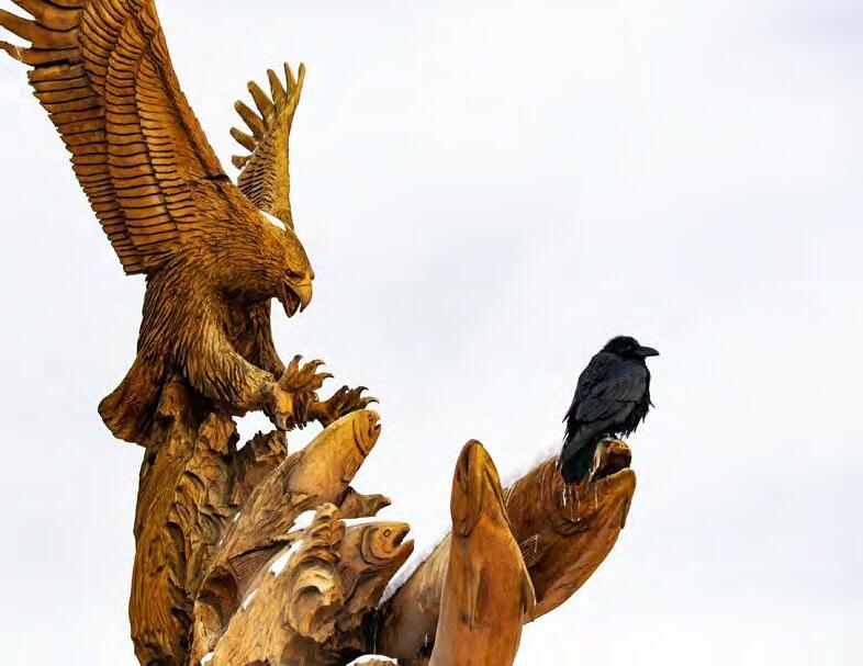
Opposite: Ravens, like this one perched on a wooden eagle and salmon sculpture outside the Copper Valley Market (p. 51) in Glennallen, make more than 30 distinct vocalizations. Ravens are among the most intelligent birds and can solve problems using logic, learn through observation, and recognize different individuals of various species. They interact with carnivores that provide scavenging opportunities, and have been observed calling wolves and other predators to animal carcasses, knowing predators would tear them open and provide access to meat. Photo by Jeremy Pataky.
During the 1950s and 1960s, the Tok Cut-Off was constructed from a point 15 miles north of Glennallen to Tok, 135 miles east on the Alaska Highway. This improved Glennallen’s position as a commercial hub. Also, in 1956, a Jesuit school, Copper Valley School, was opened. That increased the population considerably by bringing to the region a number of staff and students from Holy Cross Mission in western Alaska. In 1961, “Glenallen” was renamed “Glennallen” by the US Postal Service, adding the extra “n.” It is named after Captain E.F. Glenn and Lt. Henry T. Allen, early players in the U.S. military exploration of the Copper River basin.
59 Open Year-Round Tuesday through Saturday 10 AM till 5:30 PM Mile 187.5 Glenn Highway, Glennallen, Alaska · 907-822-3200
A gallery & gift shop featuring locally made, unique artworks handcrafted by Alaskan artists, plus souvenirs, clothing, and much more!
Clothing, household items, books, movies for sale
7 Aurora Drive downtown Glennallen, Alaska 907-822-4447
Monday - Saturday, 11 am - 7 pm


Mile 186.5 Glenn Highway, Glennallen 907-822-4222 restaurant 907-822-3302 hotel Caribouhotel.com Your gateway to the Copper River Valley and Wrangell-St. Elias National Park Caribou Hotel & Grill

Allen was a descendant of Reuben Sanford, namesake of Mt. Sanford, a major volcano in the western Wrangell Mountains all named by Allen.
Construction of the Trans-Alaska Pipeline from 1975–1977 boosted Glennallen’s economy, as does the ongoing service needs of the pipeline. The economy of the area was negatively impacted by the construction of the George Parks Highway, which connected Anchorage to Denali National Park and Fairbanks along the Alaska Railroad route, diverting traffic away from the Copper Basin.
Today, Glennallen is a major population center with roads heading in every direction. The many communities, lakes, and rivers surrounding WrangellSt. Elias National Park and other public
lands make the Copper River Basin a great area to explore, and a wonderful place to live for the local people who love this special part of Alaska.

61
KMXY
Jeremy Pataky


62 sporting goods · pet supplies groceries · camping gear full liquor selection gas Just four miles south of Glennallen Richardson Highway Mile 111 907-822-3277


Alaska Copper River

Far left: A long straightaway points toward the Wrangells on the Edgerton Highway after one turns toward Chitina from the Richardson. Painting by Jennifer Kosharek. Left: The Richardson Highway affords travelers views and access to the Trans-Alaska oil pipeline that connects Prudhoe Bay with the Valdez Marine Terminal. The pipeline is 48 inches in diameter and 800 miles long. It crosses three mountain ranges and over 500 rivers and streams. By turns above ground and underground, it was the largest privately funded construction project to date in 1977 when it was completed after a two year, $8 billion effort. It first moved oil on June 20, 1977.


63
B & B comfortable rooms Mile 111.3 Richardson Highway Tazlina, just south of Glennallen call or text 907-259-3255 alaskacopperriverbb.weebly.com Margaret Billinger JACK WHITE REAL ESTATE CRS, ABR, GRI, e-PRO 907-841-2188 margaretbillinger.com Margaret Billinger Your start-to- nish realtor in Southcentral & Eastern Alaska Invest now in the beauty and potential of Alaska’s Copper River Valley · No property tax and no state income tax. · World class shing, hunting, skiing, and backcountry exploration. · Business opportunities of a lifetime. Contact Margaret Billinger today to learn what’s available from Valdez to McCarthy to Anchorage.

64 Serving the entire 907-822-3303 Copper River Valley * Wreckmaster certified * Light, medium, & heavy jobs * Landoll: containers, equipment, etc. Gas, Diesel, Propane, Tires Full Service Auto & Truck Repair Glennallen, Alaska · Next to the Caribou Hotel Mile 187 Glenn Highway a Glennallen Fuel Glennallen Towing
Bear Country Basics

Black and grizzly bears live in the Kennicott Valley. Do your part to keep people safe and bears wild. People who let bears eat human food create a hazard for the entire community.
Campers Store your food, your pet’s food, and even toiletries properly. Use enclosed containers in vehicles at campgrounds or private property, and bear-safe containers in the backcountry (check them out at NPS Kennecott Visitor Center). Keep a clean camp and store cooking supplies, dishes, and secured food away from tents. Locate tents, kitchen, and food storage 100 yards apart from one another.

Hikers, Runners, & Bikers
Stay alert and attentive. Keep your stuff with you. Bears do venture onto glaciers. Make noise to avoid surprising one, especially in dim light or dense vegetation. Learn to prevent encounters and how to behave if you do meet a bear. Read “Bear Facts” or “Traveling in Bear Country,” available in NPS visitor centers. Consider watching the 30 minute film called Staying Safe in Bear Country on YouTube.
Bear spray is a well-proven, effective deterrent. KMXY

Left: Claw scars in aspen trees are common around McCarthy and fun to see. Black bears spend a lot of time in trees and climb them when threatened. Cubs learn early to climb trees for safety. Bears also climb aspen trees in the spring to access and eat catkins. Above: Plants are a huge part of bears’ diets, especially in interior Alaska, and early greenup along roads in spring can attract bears, like this one encountered near McCarthy. Photos by Jeremy Pataky.
65
Nabesna Road & Tok Cutoff

TokCut-off (Route 1) The Glenn Highway · Tok Cut-off is the main route linking the Alcan and Anchorage. That full distance is 328 miles, and 125 of those miles comprise the Tok Cutoff, connecting Tok and the Richardson Highway at a point 14 miles north of the junction of the Richardson and Glenn Highways.
Chistochina is on the Tok Cut-off. It began as an Athabascan fish camp. In 1887, the village access trail became part of the Valdez-Eagle Trail, which was constructed by miners during the gold rush. A trading post was established in the early 1900s. Chistochina is still an Athabascan village, and has remained one of the most traditional Ahtna Athabascan villages. Elders in the village pass on traditions and culture to youth.
Posty’s Sinona Creek Trad-
ing Post (p. 64) Fuel, propane, groceries, snacks, authentic Native arts, crafts, and gifts. Open year-round at Tok Cut-off MP 34.5.
Slana is the name of an Alaska Native village and a river. The Nabesna Mine opened nearby in 1923 and employed 60 people at its height. It operated sporadically till the late ’40s. Slana grew rapidly in the ’80s through federal homesteading around the Slana Roadhouse, listed in the U.S. National Register of Historic Places. Visit or call the NPS Ranger Station at Slana (907-822-4701) for road conditions and info.
Nabesna Road Explore the north end of the park by driving the Nabesna Road, a quiet, scenic, unpaved 42-mile road crossed by intermittent flowing
66

Wrangell Mountains Wilderness Lodge

water. It begins an hour south of Tok at the Slana Ranger Station—worth a stop. The Skookum Volcano hike is among the area’s most spectacular, but approaching the trailhead toward the end of the road by car requires transiting a steep-ditched single-lane stretch just prior. 4WD and good clearance are recommended back there. The drive (or bike ride) affords views of the Wrangell, Mentasta, and Nutzotin Mountains and access to several hikes, campgrounds, and public use cabins, plus wildlife viewing potential. The cabins require reservations.
Private lodging options on Nabesna Road offer a wonderful chance to get to know this area. A great option for bicyclists is to park near the Slana Ranger Station (907-822-7401) and ride to Wrangell Mountains Wilderness Lodge (above) at 28 mile for the night, then out to the end of the road and back before pedaling out on day three. Birders love the area in spring, when a variety of birds can be spotted around Twin and Jack Lakes. Binoculars or scopes are use-


67 Book now: at28mile.com Open all year · 907-331-6550 Mile 28, Nabesna Road, inside the Park
Log cabins & yurts with private baths Gourmet meals by reservation Tavern Wifi Premium Comfort on the Road Less Traveled Experience untamed Wrangell-St. Elias National Park without the crowds. GAKONABREWING.COM 907-822-5609 14 miles N of Glennallen, 2 miles S of the Gakona River, overlooking the Copper River. Gakona, or Ggax Kuna’, is Athabascan for Rabbit R. Tasting room, tours, epic views, cans to go. check hours online Opposite: Skookum Volcano trail begins at Mile 36.2 Nabesna Road. The 2.5 mile (one way) hike leads through an extinct, deeply eroded volcanic system with colorful and fascinating geology. Photo by Martin Capek.
ful for finding Dall sheep lambs, ewes, and rams on the hills above Jack Creek. Cell coverage is spotty and fuel is unavailable, so gas up first and be self-reliant. Allow 1.5 hours each way at least. A word of caution about the old bulldozer road beyond road’s end—heed the warning signs and don’t park near 42 mile. The old road is impassable to highway rigs a short way in, and it just might take a while to summon a tow. KMXY


Trans-Alaska Pipeline North to Paxson Chistochina Rich a r d s no H yw Gakona River WrangellSt. Elias National Park and Preserve 4 Gulkana River Raft Rentals MP 127 SanfordRiver Gulkana River TokCut-OffCopperRiver South to Glennallen Gakona Posty’s Sinona Creek Trading Post MP 34.5 New Skies Rafting & Fishing Just two roads lead into Wrangell-St. Elias National Park (an area 123% as large as Switzerland)... the 60 mile McCarthy Road, and the 42 mile Nabesna Road on the north side.


Mile 34.5
Cut-off Chistochina, Alaska
Since 1946 · Local Alaska Native artwork & beadwork. Groceries, fuel, showers, laundry, and more Milan East to Tok & Canada Dead Dog Hill Rest Area MP17.8 Copper Lake Slana TokCut-Off NabesnaRoad Tanada Lake Nabesna NPS Slana Ranger Station Rock Lake Wayside MP21.8 Jack
Kendesnii
MP27.8 MentastaMountains Nabesna
MP60 S N E W Caribou Creek Cabin Viking Lodge
53 Wrangell Mountains Wilderness
MP28
Tok
· 907-822-5454
River Rest Area MP35.3
Campground
Road Junction
Grizzly Lake Campground MP
Lodge


70 Guided rafting & salmon, grayling, and trout fishing on the scenic Gulkana, Klutina, & Copper Rivers 907-320-0787 · 828-691-8149 · newskiesalaska.com Float with us on your way to or from Wrangell-St. Elias National Park! Shuttles & rentals, too! Gakona, Alaska Mile 3 Tok Road Grizzly Lake Campground 907-822-5214 MP 53 Tok Cutoff near Slana, Alaska lakeside cabins · RV & tent sites showers · fishing · boat rentals Enjoy the feel of remote Alaska while on the road system.
Top: Nabesna Road views. Photo by Victoria Rego. Middle: Summer views from the Nabesna Road. NPS photo. Bottom right: Autumn along Trail Creek. Bottom left: Skookum Volcano in the fall. Photos by Victoria Rego.


71
Chitina & Kenny Lake

Chitina (“CHIT-nuh”) offers a post office, food, gas, a hotel, B&Bs, alcohol, light groceries, and a post office. It’s located at the end of the Edgerton Highway, which branches off the Richardson Highway between Glennallen and Thompson Pass. The McCarthy Road starts at Chitina and leads into Wrangell-St. Elias National Park. Chitina’s airstrip serves the backcountry and McCarthy through Wrangell Mountain Air.
Chitina’s heyday coincided with the operation of the Copper River and Northwestern Railway, built to link Kennecott mines to market. It hauled copper ore and supplies between the mines and Cordova. Chitina provided an intermediate stop for trains and passengers. Trains, stagecoaches, dog sleds, and steamboats all passed through Chitina during its boom years, 1910-1938.
The Chitina NPS Ranger Station (907-823-2205), a 1910 log cabin, is located at the end of the paved Edgerton Highway near the beginning of Mc-
Top: The different colored waters converging mark the precise confluence of the Chitina (right) and Copper (left) Rivers, as seen from a bluff between “the cut” at the edge of Chitina town and the Copper River bridge. The distant white mountain is Blackburn, or K’ats’i Tl’aadi to the native Ahtna. Photo by Jeremy Pataky.
Carthy Road, about an hour from the Wrangell-St. Elias Visitor Center and park headquarters near Copper Center. It provides exhibits and info on the road, hikes, fishing opportunities, and more.
The station is decorated with historic photos featuring Chitina. It was constructed to house J.C. Martin, manager of the Ed S. Orr Stage Company, whose initials are legible on the ceiling. The home was deemed “one of the neatest and most substantial log cabin cottages in Alaska.” Locals rehabilitated it in 1991-1992.
Today, dipnetting, fish wheeling, and boat fishing near Chitina attract AK residents each summer from as far away as Fairbanks and Anchorage. Copper River reds (sockeye) are famous throughout the world. This far upriver, it’s strictly a personal use and subsistence salmon fishery. These upstream waters feed residents well. Commercially harvested Copper River salmon are caught down in the delta. Licensed nonresidents still have plenty of fishing options, including lakes near Chitina and along McCarthy Road, Klutina and Gulkana Rivers, saltwater fishing in Valdez, and more.
Chitina marks the last chance to get gas before the McCarthy Road—make
72


73 Chitina’s only full RV hookups. Great Wrangell Mountains views. Walk to the Copper River & airstrip. Mile 28 Edgerton Highway Book: wrangellviewrvpark.com Information: 907-823-2265 Chitina was founded in 1910 as a construction camp for the Copper River & Northwestern Railway. The area became a boom town when the railroad arrived in 1910. When the Kennecott mining company ceased operations in 1938, and most locals left, Chitina, like McCarthy, became a bit of a ghost town. In 1980, Wrangell-St. Elias National Park and Preserve was created. Chitina became a gateway for visitors traveling the McCarthy Road. Photo by Tenley Nelson. Welcome to Fish Camp! call or text 907·903·2329 ak-x.com At McCarthy Rd. Mile 0 right in Chitina, we’re your launch or landing pad going to or from McCarthy. RV & tent spots, quonset hut & tent rentals, power hook ups, water, flake ice, firewood & pits, grills. Co ee, espresso, smoothies. Gifts. Free wifi. Home base, too, for Alaskan charter dipnetters pursuing famous Copper River salmon.


74 Wrangell View Store Spirit Mountain Gas GROCERIES, ICE, SODA, SNACKS, TACKLE, SUNDRIES, FISHING LICENSES, TOBACCO RV friendly pull-through. Extended summer hours. Mile 33.5 Edgerton Hwy. 907-823-2265 Chitina 24-7 gas in Chitina. Card only. Mile 33. Gateway to WrangellSt. Elias National Park Business for Sale Hotel · Restaurant · Saloon historic, restored 1914 building * year round liquor license * greenhouse beer garden * RV slots & room to expand * Copper R. & Park gateway Mile 34 Edgerton Hwy,Chitina 907– 823-2244 * 907-255-2020 info@hotelchitina.com Open daily! Memorial Day through Labor Day custom burgers · homemade bbq · reindeer sausage jambalaya · hand-scooped milkshakes ~ Weekly Chef Specials ~ Mile 33 Edgerton Highway next to Uncle Tom’s Tavern K Chitina, Alaska Fine Art & Quality Crafts since 1978 907-823-2222 22 Main Street, Chitina browse online

sure you have enough to get out and back (120 miles roundtrip), though for the first time, gas should be available to the public near the end of the road at As the Glacier Melts Cafe (p. 1) starting in 2024.
As you head out, look upstream from the bridge to see some remnant fishwheels—most got wrecked in recent fall floods, and the shifting Kotsina River. complicated access. Downstream, view the confluence of the Copper River. and Chitina River, and perhaps some dipnetters.
Half of Chitina’s 100 or so residents are Ahtna Athabaskan, decendents of expert traders. Chitina’s original Native settlement was Taral, on the trade route south to the coast.
Kenny Lake, pop. 400, is located from miles 1 to 17 on the Edgerton Highway and miles 1 to 8 of the Old Edgerton, and was one of the last farming communities settled in the country.
The Ahtna people were the area’s first inhabitants. Settlers arrived in the early 1900s along the new road connecting Chitina to the interior. Ina and Guy Simmons, originally from Kansas City, MO, ran the Kenny Lake Roadhouse for a decade starting around 1920.
When the copper mines closed in 1938, Chitina and Kenny Lake experienced an exodus. A few people remained, living a rural lifestyle.
During the ’50s, the community grew. The state began converting the railroad corridor into a road in 1960 while also completing major upgrades to the Edg-
75


erton. The new highway opened in 1964. In 1971, it was paved as far as the Lower Tonsina River. In 1991, the pavement reached Chitina. The Alaska Homestead Act brought more settlers into the area in the ’60s through its end in the ’80s. Folks were expected to build cabins and live on the land for at least six months per year for five years to “prove up,” thus becoming legal land owners. Many then subdivided and sold parcels. Many locals still raise farm animals and grow hay and vegetables. There’s a public school and library, a feed and seed business, general stores, food and lodging, and more. Well water is scarce for much of the area, so most residents haul water from community wells or have it delivered. The Kenny Lake Fair always draws a crowd. KMXY
76 Kenny Lake Mercantile & RV Park and Hotel Kenny Lake, Alaska Mile 7.2 Edgerton Highway kennylakervpark.wixsite.com/kennylakemerc 907·822·3313 kennylake@cvalaska.net ~ beautiful views of the Wrangell Mountains ~ electric sites · dry rv & tent sites · dump station · groceries ice · fresh water · gas · diesel · propane rooms with TVs · laundromat · showers open year round Year-Round Lodging in Kenny Lake 5 private cabins & 15 B&B rooms MENTION THIS AD, SAVE 5% 907· 255· 5503 homesteadalaska.com

cozy log cabins


Above: Of Alaska’s 15 highest peaks, 12 are in Wrangell-St. Elias National Park. One of them, Mount Wrangell, or, K’ełt’aeni, to the Ahtna (and K’ełedi when erupting), is a massive shield volcano, visible here on the right. It rises over 12,000’ above the Copper River. On cloudless days, small puffs of steam often vent visibly from the north crater near the summit. Photo by Jeremy Pataky.
77
restaurant espresso Rustic ambiance. Charm & comfort. Reserve now and enjoy the spectacular gateway to Wrangell-St. Elias National Park! 907-987-2556 · goldensprucelodging.com new ownership kenny lake · mile 9.3 edgerton highway

Copper Center
Copper Center is on a loop road off the Richardson, about 100 miles north of Valdez and one mile west of the Klutina and Copper Rivers’ confluence. Its origins connect with the Klondike Gold Rush in 1898, when prospectors sought an all-American route to Dawson City via Valdez (so they could bypass Canadian law enforcement outside Skagway/Dyea). At that time, the Ahtna had summer fish camps on the Copper and winter villages throughout the region.
Old Copper Center began when gold rushers gave up on trying to reach the distant Klondike and stayed, creating a market for entrepreneurs to provide materials and services to them as well as the nearby Natives. The community of Copper Center is a point along the historic Valdez to Eagle Trail, which began as a Native trail. The first telegraph line in Alaska traced the route. In 1905, a school was built in Copper Center, which eventually brought Native families to town. The trail was upgraded to a wagon road in 1910, then to an automobile road in the ’20s that got paved in 1957 as the Richardson Highway.
Copper Center’s population, includ-
ing the nearby village, Kluti Kaah, totals about 450. Businesses include RV parks, river boat charters, lodging and dining, gift shops, and tour companies. The George I. Ashby Memorial Museum (p. 75)is located on the loop road next to the Old Town Copper Center Inn & Restaurant (p. 75), the current incarnation of the historic Copper Center Lodge. That place is listed on the National Register of Historic Places. Fire destroyed the original building in 2012.
Wrangell-St. Elias Visitor Center in Copper Center
The NPS operates visitor centers in Chitina, Kennecott, Slana, and Copper Center. The latter isn’t really in Copper Center, though it’s close—10 miles south of the

78
Jeremy Pataky


79 Family owned and operated since 1948. Serving beer, including Alaska microbrews, & wine. check online for current hours Closed Sunday & Monday Mile 101 Old Richardson Hwy on Loop Road Copper Center, Alaska OldTownCopperCenter.com 907-822-3245 George Ashby Memorial Museum June 1st to September 1st Mon–Sat · 10 am to 3 p Sunday · 1 to 3 pm 907-822-5285 Visit in Copper Center, Alaska * 1898 Gold Rush artifacts * Indigenous Athabascan artifacts * 20th c. copper era artifacts * Books, gifts, & crafts for sale Uncle Nicolai’s Inn & Hostel B&B Hostel bunkhouse · Private rooms with & without attached lavatory. Bar · Continental breakfast · Walking distance to restaurant. On the Klutina River in Copper Center, Alaska 907-822-3003 or -3310 UncleNics.com Chief Nicolai’s Diner will be a full-service restaurant in a historic railroad coach built in 1949 for the Union Pacific. Coming soon! Halfway in drive time between Anchorage & McCarthy. 3.5 hours each way, and just minutes from the Richardson Hwy.


the Ahtna Region Available to Everyone! walk-in clinic + chiropractic + physical therapy + behavioral health + dental + pharmacy + massage + and more
Mile 111.5 Richardson Highway Glennallen, Alaska 907-822-5241

QUALITY HEALTH CARE
in


Glenn/Richardson junction in Glennal len, at Richardson mile 106.8. It’s not really in the park, either, but provides info on the whole park, and views of the western Wrangell Mountains from a na ture trail—a great place to stretch legs and eyes mid-journey. Keep a sharp look out for the brown signs that mark the entrance—easy to miss. The campus has restrooms, plenty of parking for rigs big or small, a theater with a park film, picnic tables, exhibits, and the park’s main administrative and management offices. Great book and gift shop. Hours can vary. Call 907-822-7250 to check them or to ask questions. Parking lot is gated and locked at 5:30PM in summer and closed in winter. No overnighting. Check out the Ahtna Cultural Center—a must to learn about local Athabascan culture (907-822-3535). KMXY


81
Copper River • Denali • Fairbanks • Kenai • Mt. McKinley
Topping out at 2,678’ in Thompson Pass, the Richardson Highway winds through the Chugach Mountains and some of Alaska’s most stunning scenery. Views include sites like Worthington Glacier (pictured) as well as features of the built environment like snow fences, the Trans-Alaska Pipeline and its pump stations, and electrical lines routing hydro power from Valdez to the Copper River Valley.

Valdez
Valdez (pronounced val DEEZ, not val DEZ) is about 175 miles from McCarthy. The gorgeous drive leads through Thompson Pass, rich with mountain, glacier, and river views. Keystone Canyon and striking waterfalls are highlights near town. Located on gorgeous Prince William Sound at the feet of the Chugach Mountains, it is popular with RVers.
In 1897, the Port of Valdez was a launch point for gold rushers heading inland. Valdez bustled in the first two decades of the last century. Beyond the staples of mining and shipping, fishing, fox farming, and tourism industries thrived. On March 27, 1964, the infamous Good Friday Earthquake struck Alaska. Beginning at 5:36PM and lasting over four minutes, it struck just 45 miles west of Valdez. A quake-caused underwater landslide in turn triggered tsunamis. One washed away the Valdez waterfront, drowning 30 people. Over 114 were killed in Alaska by the quake.
The Valdez townsite was condemned when they learned how unstable the ground was there. In 1967, three years
after the quake, the entire town was moved to its present location, four miles east of old Valdez. Fifty-two buildings were moved and the rest were razed. The route into the old site is just past the road to the airport.
During the 1970s, the Port of Valdez became a vital link for the Trans-Alaska Pipeline, which terminates at a 1,000 acre marine terminal there. Perhaps that made up for losing out on the contest with Cordova around the turn of the century to serve as the rail link for Kennecott.
Today, the population of Valdez is about 4,500 people who work for the city, the oil industry, or in winter and summer tourism, fishing, or transportation and shipping. It’s a fantastic place to fish for halibut and salmon and to backcountry ski and ice climb in the winter. Helicopter flightseeing and sea kayaking can also be well worthwhile. Wildlife in the area includes sea otters, Dall porpoises, harbor seals, Stellar sea lions, humpback whales and orcas, bears, and abundant bald eagles.
Check out the Valdez Visitors Infor-
82
Nestled between towering mountains, at the end of a glittering fjord and along the shores of Prince William Sound, find the charming town of Valdez. With tidewater glaciers, rainforests, and majestic mountains in its backyard, Valdez offers stunning backdrops for year-round adventure.


Come to fish, hike, view glaciers and wildlife, kayak, bike, ski, snowboard, snowshoe, and so much more. Accessible by land, air, and sea, Valdez is the ultimate year-round Alaska destination.
@discover
@discovervaldez valdezalaska.org
907·835·2984
valdez
309 Fairbanks Drive, Valdez
Adventure begins where the road ends —
in Valdez!
VALDEZ, ALASKA


PRINCE WILLIAM SOUND GLACIER & WILDLIFE CRUISES

84
We take the time to let you experience ALL of the Sound - from the magnificent icebergs of Columbia Glacier, calving Meares Glacier, to incredible wildlife. Let us show you what the Sound has to offer as we share with you the remarkable history, geology and information of this abundant region.
stanstephenscruises.com • 866.867.1297
mation Center and the Valdez Museum and Historical Archives located downtown... and the Potato, a second location of the restaurant that started in McCarthy.
don’t miss...
Old Town Site The road into town passes the original town site. A tsumani triggered by the 1964 Good Friday Earthquake destroyed Old Valdez. You can still see the layout of its streets and port.
Forest
Service
Visitor
Center On the right just before you come into Valdez, a log cabin stands at the base of the hill. Worth a stop, this U.S. Forest Service Visitor Center has loads of info on wildlife and area public-use Forest Service cabins, as well as a small gift shop. View the waterfall out back and look for salmon spawning when the time is right.
Dayville Road Drive out Dayville Road to see the other side of Valdez Arm. The drive leads past the Allison Creek Hydroelectric station and a hatchery, a great place to view wildlife. Bears, sea lions, and seabirds frequent the area to feed on salmon. A bike path parallels the ocean. Allison Point Campground offers toilets, parking, and RV camping. The road ends at the terminus of the TransAlaska Pipeline, where oil rigs often dock.


85

drive
Getting to Valdez
Proclaimed one of
“America’s Most Scenic Roads” and known to Alaskans as the “Adventure Corridor,” the drive to Valdez provides breathtaking views of glaciers, waterfalls, and mountains. The drive through Thompson Pass passes the Worthington Glacier. During winter, the pass is buried under snow (hence the tall snowplow guide posts and snow barricades along the way).
fly Short daily flights from Anchorage offer spectacular views of the coastal Chugach Mountains, vast icefields and glaciers, and Prince William Sound.
ferry The Alaska Marine Highway is a beautiful way to reach or depart Valdez while experiencing the marine environment. The 100 mile crossing between Valdez and Whittier makes loop routes possible, linking, say,
Thompson
Pass Area
Anchorage, McCarthy and the Copper Basin, Valdez, and Whittier (itself just 50 miles from Anchorage). Expand your itinerary with a trip to Cordova by ferry or short flight, as well.
North to Copper Center and Glennallen
86
EdgertonHwy KennyLake,Chitina 4 TonsinaRiver Pippin Lake Tonsina Lake M 8 2 .5 Valdez Arm Trans-AKpip e l i ne Blue Berry Lake State Recreation Site Squirrel Creek State Recreation Site MP 79.5 US Forest Service Visitor’s Center Shoup Bay Pipeline Terminal Dayville Road Valdez Keystone Canyon Emergency phone MP 56 at Tiekel River Lodge Lowe River Allison Point Campground Glacier Campground waterfall N S E W Mt. Billy Mitchell State Recreation Site MP 48 Worthington Glacier State Recreation Site
Highway ferry terminal
with
and points beyond. KMXY
Top: The Alaska Marine
connects Valdez
Whittier, Cordova,


KMXYvisitorsguide. com Kennecott-McCarthy Visitors Guide 2018 Chitina Copper Center Glennallen Kenny Lake Kennecott McCarthy Valdez KMXYvisitorsguide.com Kennecott-McCarthy Visitors Guide Local Knowledge for Travel in Alaska’s Greater Copper Country Kennecott · McCarthy · Chitina · Kenny Lake Copper Center · Glennallen · Nabesna · Valdez It’s no coincidence that the word “adventure” starts with “ad.” Reserve your 2025 ad now and we’ll send adventurers your way. We have pull. Local Knowledge for Travel in Alaska’s Greater Copper Country


88 B ! pizza, wings, soft serve, & more 131 East Pioneer Drive, Valdez · 907-835-2343 Downtown B&B Inn Clean and affordable rooms close to all Valdez a ractions and activities 907-835-2791 or 800-478-2791 113 Galena Drive, Valdez valdezdowntowninn.com · knowledgeable, friendly staff · great mountain views · reasonable rates · free wifi


Below:

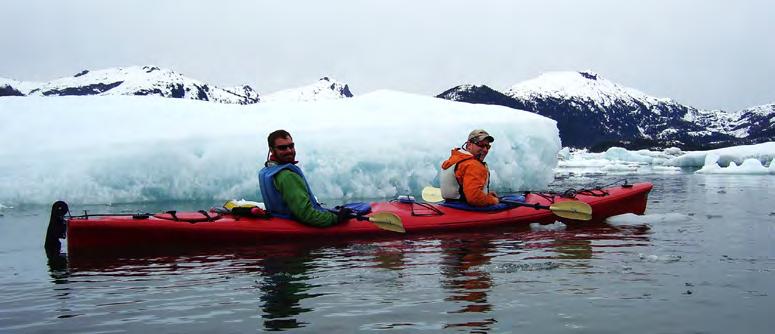
89
Above: McCarthy residents and visiting family fill the freezer on a fishing trip out of Valdez.
Photos courtesy of Amanda Swinehart.
Right: An iceberg that originated from Columbia Glacier glows in the waters of Prince William Sound outside of Valdez.
Photo by Jeremy Pataky.
Kayaking among Columbia Glacier icebergs in Prince William Sound.
Photo by Corey Belt.

CHECK LAND OWNERSHIP WHILE ON THE GO

90 GET THE LAND APP

91


Wrangell Mountain Air Backcountry Access, Fly-in Day Trips, and Flightsees in America’s Largest (and most stunning) National Park FLYING 30+ YEARS in Wrangell-St. Elias National Park: North America’s Mountain Kingdom 1-800-478-1160 wrangellmountainair.com info@wrangellmountainair.com