BACKCOUNTRY FIELD BOOK
RECREATIONAL


Silverton Avalanche School Backcountry Field Book - Version II Created and Produced by Silverton Avalanche School. ©Copyright 2020 All rights reserved. Visual Design & Layout by Katarina Ochabova | kitkatcreative.com https://avalanche.org RECREATIONAL PROFESSIONAL RESCUE https://avalanche.org/us-avalanche-centers 0 1/4 1/2 3/4 1 MILE 1:24,000 Maps40' contours 20 ° 20 ° 30 ° 30 ° 40 ° 40 ° 60 ° 50 ° 50 ° Slope Angle Scale 1:24,00040' contours 0cm 1 2 3 4 5 6 7 8 @ avyschool Backcountry Awareness Information www.NoBlackoutDays.com Check the Forecast!
Name
EMERGENCY INFORMATION
Phone number
Emergency Contact Name
Emergency Contact Phone
Medical Allergies
Medications
Blood type
Medical History:
1 SILVERTON AVALANCHE SCHOOL
What snowpack factors concern me and why?
What weather factors could affect avalanche activity?
2 SILVERTON AVALANCHE SCHOOL PROBLEM ASPECT ELEV. LIKELIHOOD SIZE TREND WEAK LAYER Group Location Date
TREND Improving Maintaining Deteriorating BELOW TREELINE NEAR TREELINE ABOVE TREELINE Avalanche Danger Scale Rating FORECAST TEMP WIND SP WIND DIR. SKY COVER PRECIP. LOCATION NOWCAST CBP AVALANCHE OBSERVATIONS KEY DISCUSSION POINTS CBP (See pg. 51 for ref.) See pg. 48-50 for Problem Type ref.
What terrain am I avoiding and why?
Challenging Complex
ATES
(Avalanche Terrain Exposure Scale)
See pg. 45 for ATES ref. Group discussion.
TOUR PLAN:
STEPPING OUT
STATUS QUO
ASSESSMENT
ENTRENCHMENT OPEN SEASON
STEPPING BACK
SPRING DIURNAL
See pg. 47 for Strategic Mindset ref.
We'll push into the BC cautiosly today and be ready to bail back down the way we came at any moment-we will not commit to movement we cannot retreat from or places us in avy terrain.All members have radios/inreach/cell phone/avy rescue kit, bivy bag, warm layers + survival supplies. in/out via 550 for evac.
EMERGENCY RESPONSE PLAN:
3 SILVERTON AVALANCHE SCHOOL
Simple
FIELD SNOWPACK AND WEATHER OBSERVATIONS
RED FLAGS
OBSERVATION LOCATION
ELEVATION (ASL)
DATE
TIME
OBSERVER(S)
SKY CONDITIONS
CURRENT PRECIPITATION
AIR TEMP.
SNOW TEMP.
BOOT / SKI PENETRATION
TOTAL SNOW DEPTH
24-HOUR NEW SNOW DEPTH
HEIGHT OF STORM SNOW
WIND
DIRECTION
WIND SPEED
MAX. WIND GUST
BLOW SNOW
NEW SNOW RECENT AVALANCHES
RAPID TEMP. RISE
COLLAPSING/ CRACKING
RAIN ON SNOW
SNOW TRANSPORT BY WIND
NOTES:
DEBRIEF - WHAT? SO WHAT? NOW WHAT?
See P. 42 for Observation Recording Parameters ref.
4 SILVERTON AVALANCHE SCHOOL
Date:
Observer(s): Location:
Time:
Sky Condition: Elev./Aspect: Wind Speed/Dir.: Slope Angle:
SNOW PROFILE
Air Temp.: Precip.:
Common weak layer characteristics:
• Weak layer is softer than 1F.
• Weak layer has angular, sugary grains (SH, DH, FC)
• Weak layer grains are large (>1mm)
• Layer above or below has a grain size difference >0.5mm
• Layer above or below is a step firmer
• Weak layer is found less than 1m deep.
When identifying weak layers “focus on soft coarse-grained layers, especially when just above or just below a harder fine grained layer, and between 20 and 85cm below snow surface.”
-B.
J. Schweizer. Dec. 2015
5 SILVERTON AVALANCHE SCHOOL
Blowing Snow? Y N PREV Ski Pen: cm. in. Boot Pen: cm. in. Snow Layer Temp (°C) -18° -16° -14° -12° -10° -8° -6° -4° -2° Depth H Form F Test Results and Comments I K P 1F 4F F 5 20 170 160 150 140 130 120 110 90 80 70 60 50 40 30 20 10 0 100
Jamieson,
What snowpack factors concern me and why?
What weather factors could affect avalanche activity?
6 SILVERTON AVALANCHE SCHOOL Group Location Date PROBLEM ASPECT ELEV. LIKELIHOOD SIZE TREND WEAK LAYER Improving Maintaining Deteriorating BELOW TREELINE NEAR TREELINE ABOVE TREELINE FORECAST TEMP WIND SP WIND DIR. SKY COVER PRECIP. LOCATION NOWCAST TREND Avalanche Danger Scale Rating
RECENT AVALANCHE OBSERVATIONS KEY DISCUSSION POINTS (See pg. 51 for ref.) See pg. 48-50 for Problem Type ref.
What terrain am I avoiding and why?
ATES
Challenging Complex (Avalanche Terrain Exposure Scale)
See pg. 45 for ATES ref. Group discussion.
TOUR PLAN:
STEPPING OUT
STATUS QUO
ASSESSMENT
ENTRENCHMENT OPEN SEASON
STEPPING BACK
SPRING DIURNAL
See pg. 47 for Strategic Mindset ref.
EMERGENCY RESPONSE PLAN:
7 SILVERTON AVALANCHE SCHOOL
Simple
FIELD SNOWPACK AND WEATHER OBSERVATIONS
RED FLAGS
OBSERVATION LOCATION
ELEVATION (ASL)
DATE
TIME
OBSERVER(S)
SKY CONDITIONS
CURRENT PRECIPITATION
AIR TEMP.
SNOW TEMP.
BOOT / SKI PENETRATION
TOTAL SNOW DEPTH
24-HOUR NEW SNOW DEPTH
HEIGHT OF STORM SNOW
WIND
DIRECTION
WIND SPEED
MAX. WIND GUST
BLOW SNOW
NEW SNOW RECENT AVALANCHES
RAPID TEMP. RISE
COLLAPSING/ CRACKING
RAIN ON SNOW
SNOW TRANSPORT BY WIND
NOTES:
DEBRIEF - WHAT? SO WHAT? NOW WHAT?
See P. 42 for Observation Recording Parameters ref.
8 SILVERTON AVALANCHE SCHOOL
Date: SNOW PROFILE Time:
Observer(s): Location:
Sky Condition: Elev./Aspect: Wind Speed/Dir.: Slope Angle:
Air Temp.: Precip.:
Common weak layer characteristics:
• Weak layer is softer than 1F.
• Weak layer has angular, sugary grains (SH, DH, FC)
• Weak layer grains are large (>1mm)
• Layer above or below has a grain size difference >0.5mm
• Layer above or below is a step firmer
• Weak layer is found less than 1m deep.
When identifying weak layers “focus on soft coarse-grained layers, especially when just above or just below a harder fine grained layer, and between 20 and 85cm below snow surface.”
-B. Jamieson, J. Schweizer. Dec. 2015
9 SILVERTON AVALANCHE SCHOOL
Blowing Snow? Y N PREV Ski Pen: cm. in. Boot Pen: cm. in. Snow Layer Temp (°C) -18° -16° -14° -12° -10° -8° -6° -4° -2° Depth H Form F Test Results and Comments I
P
K
1F 4F F
What snowpack factors concern me and why?
What weather factors could affect avalanche activity?
10 SILVERTON AVALANCHE SCHOOL Group Location Date Improving Maintaining Deteriorating BELOW TREELINE NEAR TREELINE ABOVE TREELINE FORECAST TEMP WIND SP WIND DIR. SKY COVER PRECIP. LOCATION NOWCAST TREND Avalanche Danger Scale Rating
DISCUSSION POINTS RECENT AVALANCHE OBSERVATIONS (See pg. 51 for ref.) PROBLEM ASPECT ELEV. LIKELIHOOD SIZE TREND WEAK LAYER See pg. 48-50 for Problem Type ref.
KEY
What terrain am I avoiding and why?
Simple
ATES
Challenging Complex (Avalanche Terrain Exposure Scale)
See pg. 45 for ATES ref. Group discussion.
TOUR PLAN:
STEPPING OUT
STATUS QUO
ASSESSMENT
ENTRENCHMENT OPEN SEASON
STEPPING BACK
SPRING DIURNAL
See pg. 47 for Strategic Mindset ref.
EMERGENCY RESPONSE PLAN:
11 SILVERTON AVALANCHE SCHOOL
FIELD SNOWPACK AND WEATHER OBSERVATIONS
RED FLAGS
OBSERVATION LOCATION
ELEVATION (ASL)
DATE
TIME
OBSERVER(S)
SKY CONDITIONS
CURRENT PRECIPITATION
AIR TEMP.
SNOW TEMP.
BOOT / SKI PENETRATION
TOTAL SNOW DEPTH
24-HOUR NEW SNOW DEPTH
HEIGHT OF STORM SNOW
WIND
DIRECTION
WIND SPEED
MAX. WIND GUST
BLOW SNOW
NEW SNOW RECENT AVALANCHES
RAPID TEMP. RISE
COLLAPSING/ CRACKING
RAIN ON SNOW
SNOW TRANSPORT BY WIND
NOTES:
DEBRIEF - WHAT? SO WHAT? NOW WHAT?
See P. 42 for Observation Recording Parameters ref.
Ref. Observation Recording Parameters P. 42
12
AVALANCHE SCHOOL
SILVERTON
Date: SNOW PROFILE Time:
Observer(s): Location:
Sky Condition: Elev./Aspect: Wind Speed/Dir.: Slope Angle:
Air Temp.: Precip.:
Common weak layer characteristics:
• Weak layer is softer than 1F.
• Weak layer has angular, sugary grains (SH, DH, FC)
• Weak layer grains are large (>1mm)
• Layer above or below has a grain size difference >0.5mm
• Layer above or below is a step firmer
• Weak layer is found less than 1m deep.
When identifying weak layers “focus on soft coarse-grained layers, especially when just above or just below a harder fine grained layer, and between 20 and 85cm below snow surface.”
-B. Jamieson, J. Schweizer. Dec. 2015
13 SILVERTON AVALANCHE SCHOOL
Blowing Snow? Y N PREV Ski Pen: cm. in. Boot Pen: cm. in. Snow Layer Temp (°C) -18° -16° -14° -12° -10° -8° -6° -4° -2° Depth H Form F Test Results and Comments I
P
K
1F 4F F
What snowpack factors concern me and why?
What weather factors could affect avalanche activity?
14 SILVERTON AVALANCHE SCHOOL Group Location Date Improving Maintaining Deteriorating BELOW TREELINE NEAR TREELINE ABOVE TREELINE FORECAST TEMP WIND SP WIND DIR. SKY COVER PRECIP. LOCATION NOWCAST TREND Avalanche Danger Scale Rating
DISCUSSION POINTS RECENT AVALANCHE OBSERVATIONS (See pg. 51 for ref.) PROBLEM ASPECT ELEV. LIKELIHOOD SIZE TREND WEAK LAYER See pg. 48-50 for Problem Type ref.
KEY
What terrain am I avoiding and why?
Simple
ATES
Challenging Complex (Avalanche Terrain Exposure Scale)
See pg. 45 for ATES ref. Group discussion.
TOUR PLAN:
STEPPING OUT
STATUS QUO
ASSESSMENT
ENTRENCHMENT OPEN SEASON
STEPPING BACK
SPRING DIURNAL
See pg. 47 for Strategic Mindset ref.
EMERGENCY RESPONSE PLAN:
15 SILVERTON AVALANCHE SCHOOL
FIELD SNOWPACK AND WEATHER OBSERVATIONS
RED FLAGS
OBSERVATION LOCATION
ELEVATION (ASL)
DATE
TIME
OBSERVER(S)
SKY CONDITIONS
CURRENT PRECIPITATION
AIR TEMP.
SNOW TEMP.
BOOT / SKI PENETRATION
TOTAL SNOW DEPTH
24-HOUR NEW SNOW DEPTH
HEIGHT OF STORM SNOW
WIND
DIRECTION
WIND SPEED
MAX. WIND GUST
BLOW SNOW
NEW SNOW RECENT AVALANCHES
RAPID TEMP. RISE
COLLAPSING/ CRACKING
RAIN ON SNOW
SNOW TRANSPORT BY WIND
NOTES:
DEBRIEF - WHAT? SO WHAT? NOW WHAT?
See P. 42 for Observation Recording Parameters ref.
16 SILVERTON AVALANCHE SCHOOL
Date: SNOW PROFILE Time:
Observer(s): Location:
Sky Condition: Elev./Aspect: Wind Speed/Dir.: Slope Angle:
Air Temp.: Precip.:
Common weak layer characteristics:
• Weak layer is softer than 1F.
• Weak layer has angular, sugary grains (SH, DH, FC)
• Weak layer grains are large (>1mm)
• Layer above or below has a grain size difference >0.5mm
• Layer above or below is a step firmer
• Weak layer is found less than 1m deep.
When identifying weak layers “focus on soft coarse-grained layers, especially when just above or just below a harder fine grained layer, and between 20 and 85cm below snow surface.”
-B. Jamieson, J. Schweizer. Dec. 2015
17 SILVERTON AVALANCHE SCHOOL
Blowing Snow? Y N PREV Ski Pen: cm. in. Boot Pen: cm. in. Snow Layer Temp (°C) -18° -16° -14° -12° -10° -8° -6° -4° -2° Depth H Form F Test Results and Comments I
P
K
1F 4F F
What snowpack factors concern me and why?
What weather factors could affect avalanche activity?
18 SILVERTON AVALANCHE SCHOOL Group Location Date Improving Maintaining Deteriorating BELOW TREELINE NEAR TREELINE ABOVE TREELINE FORECAST TEMP WIND SP WIND DIR. SKY COVER PRECIP. LOCATION NOWCAST TREND Avalanche Danger Scale Rating
DISCUSSION POINTS RECENT AVALANCHE OBSERVATIONS (See pg. 51 for ref.) PROBLEM ASPECT ELEV. LIKELIHOOD SIZE TREND WEAK LAYER See pg. 48-50 for Problem Type ref.
KEY
What terrain am I avoiding and why?
Simple
ATES
Challenging Complex (Avalanche Terrain Exposure Scale)
See pg. 45 for ATES ref. Group discussion.
TOUR PLAN:
STEPPING OUT
STATUS QUO
ASSESSMENT
ENTRENCHMENT OPEN SEASON
STEPPING BACK
SPRING DIURNAL
See pg. 47 for Strategic Mindset ref.
EMERGENCY RESPONSE PLAN:
19 SILVERTON AVALANCHE SCHOOL
FIELD SNOWPACK AND WEATHER OBSERVATIONS
RED FLAGS
OBSERVATION LOCATION
ELEVATION (ASL)
DATE
TIME
OBSERVER(S)
SKY CONDITIONS
CURRENT PRECIPITATION
AIR TEMP.
SNOW TEMP.
BOOT / SKI PENETRATION
TOTAL SNOW DEPTH
24-HOUR NEW SNOW DEPTH
HEIGHT OF STORM SNOW
WIND
DIRECTION
WIND SPEED
MAX. WIND GUST
BLOW SNOW
NEW SNOW RECENT AVALANCHES
RAPID TEMP. RISE
COLLAPSING/ CRACKING
RAIN ON SNOW
SNOW TRANSPORT BY WIND
NOTES:
DEBRIEF - WHAT? SO WHAT? NOW WHAT?
See P. 42 for Observation Recording Parameters ref.
20 SILVERTON AVALANCHE SCHOOL
Date: SNOW PROFILE Time:
Observer(s): Location:
Sky Condition: Elev./Aspect: Wind Speed/Dir.: Slope Angle:
Air Temp.: Precip.:
Common weak layer characteristics:
• Weak layer is softer than 1F.
• Weak layer has angular, sugary grains (SH, DH, FC)
• Weak layer grains are large (>1mm)
• Layer above or below has a grain size difference >0.5mm
• Layer above or below is a step firmer
• Weak layer is found less than 1m deep.
When identifying weak layers “focus on soft coarse-grained layers, especially when just above or just below a harder fine grained layer, and between 20 and 85cm below snow surface.”
-B. Jamieson, J. Schweizer. Dec. 2015
21 SILVERTON AVALANCHE SCHOOL
Blowing Snow? Y N PREV Ski Pen: cm. in. Boot Pen: cm. in. Snow Layer Temp (°C) -18° -16° -14° -12° -10° -8° -6° -4° -2° Depth H Form F Test Results and Comments I
P
K
1F 4F F
What snowpack factors concern me and why?
What weather factors could affect avalanche activity?
22 SILVERTON AVALANCHE SCHOOL Group Location Date BELOW TREELINE NEAR TREELINE ABOVE TREELINE FORECAST TEMP WIND SP WIND DIR. SKY COVER PRECIP. LOCATION NOWCAST Avalanche Danger Scale Rating
KEY DISCUSSION POINTS RECENT AVALANCHE OBSERVATIONS Improving Maintaining Deteriorating TREND (See pg. 51 for ref.) PROBLEM ASPECT ELEV. LIKELIHOOD SIZE TREND WEAK LAYER See pg. 48-50 for Problem Type ref.
What terrain am I avoiding and why?
Simple
ATES
Challenging Complex (Avalanche Terrain Exposure Scale)
See pg. 45 for ATES ref. Group discussion.
TOUR PLAN:
STEPPING OUT
STATUS QUO
ASSESSMENT
ENTRENCHMENT OPEN SEASON
STEPPING BACK
SPRING DIURNAL
See pg. 47 for Strategic Mindset ref.
EMERGENCY RESPONSE PLAN:
23 SILVERTON AVALANCHE SCHOOL
FIELD SNOWPACK AND WEATHER OBSERVATIONS
RED FLAGS
OBSERVATION LOCATION
ELEVATION (ASL)
DATE
TIME
OBSERVER(S)
SKY CONDITIONS
CURRENT PRECIPITATION
AIR TEMP.
SNOW TEMP.
BOOT / SKI PENETRATION
TOTAL SNOW DEPTH
24-HOUR NEW SNOW DEPTH
HEIGHT OF STORM SNOW
WIND
DIRECTION
WIND SPEED
MAX. WIND GUST
BLOW SNOW
NEW SNOW RECENT AVALANCHES
RAPID TEMP. RISE
COLLAPSING/ CRACKING
RAIN ON SNOW
SNOW TRANSPORT BY WIND
NOTES:
DEBRIEF - WHAT? SO WHAT? NOW WHAT?
See P. 42 for Observation Recording Parameters ref.
24 SILVERTON AVALANCHE SCHOOL
Date: SNOW PROFILE Time:
Observer(s): Location:
Sky Condition: Elev./Aspect: Wind Speed/Dir.: Slope Angle:
Air Temp.: Precip.:
Common weak layer characteristics:
• Weak layer is softer than 1F.
• Weak layer has angular, sugary grains (SH, DH, FC)
• Weak layer grains are large (>1mm)
• Layer above or below has a grain size difference >0.5mm
• Layer above or below is a step firmer
• Weak layer is found less than 1m deep.
When identifying weak layers “focus on soft coarse-grained layers, especially when just above or just below a harder fine grained layer, and between 20 and 85cm below snow surface.”
-B. Jamieson, J. Schweizer. Dec. 2015
25 SILVERTON AVALANCHE SCHOOL
Blowing Snow? Y N PREV Ski Pen: cm. in. Boot Pen: cm. in. Snow Layer Temp (°C) -18° -16° -14° -12° -10° -8° -6° -4° -2° Depth H Form F Test Results and Comments I
P
K
1F 4F F
What snowpack factors concern me and why?
What weather factors could affect avalanche activity?
26 SILVERTON AVALANCHE SCHOOL Group Location Date Improving Maintaining Deteriorating BELOW TREELINE NEAR TREELINE ABOVE TREELINE FORECAST TEMP WIND SP WIND DIR. SKY COVER PRECIP. LOCATION NOWCAST TREND Avalanche Danger Scale Rating
DISCUSSION POINTS RECENT AVALANCHE OBSERVATIONS (See pg. 51 for ref.) PROBLEM ASPECT ELEV. LIKELIHOOD SIZE TREND WEAK LAYER See pg. 48-50 for Problem Type ref.
KEY
What terrain am I avoiding and why?
Simple
ATES
Challenging Complex (Avalanche Terrain Exposure Scale)
See pg. 45 for ATES ref. Group discussion.
TOUR PLAN:
STEPPING OUT
STATUS QUO
ASSESSMENT
ENTRENCHMENT OPEN SEASON
STEPPING BACK
SPRING DIURNAL
See pg. 47 for Strategic Mindset ref.
EMERGENCY RESPONSE PLAN:
27 SILVERTON AVALANCHE SCHOOL
FIELD SNOWPACK AND WEATHER OBSERVATIONS
RED FLAGS
OBSERVATION LOCATION
ELEVATION (ASL)
DATE
TIME
OBSERVER(S)
SKY CONDITIONS
CURRENT PRECIPITATION
AIR TEMP.
SNOW TEMP.
BOOT / SKI PENETRATION
TOTAL SNOW DEPTH
24-HOUR NEW SNOW DEPTH
HEIGHT OF STORM SNOW
WIND
DIRECTION
WIND SPEED
MAX. WIND GUST
BLOW SNOW
NEW SNOW RECENT AVALANCHES
RAPID TEMP. RISE
COLLAPSING/ CRACKING
RAIN ON SNOW
SNOW TRANSPORT BY WIND
NOTES:
DEBRIEF - WHAT? SO WHAT? NOW WHAT?
See P. 42 for Observation Recording Parameters ref.
28 SILVERTON AVALANCHE SCHOOL
Date: SNOW PROFILE Time:
Observer(s): Location:
Sky Condition: Elev./Aspect: Wind Speed/Dir.: Slope Angle:
Air Temp.: Precip.:
Common weak layer characteristics:
• Weak layer is softer than 1F.
• Weak layer has angular, sugary grains (SH, DH, FC)
• Weak layer grains are large (>1mm)
• Layer above or below has a grain size difference >0.5mm
• Layer above or below is a step firmer
• Weak layer is found less than 1m deep.
When identifying weak layers “focus on soft coarse-grained layers, especially when just above or just below a harder fine grained layer, and between 20 and 85cm below snow surface.”
-B. Jamieson, J. Schweizer. Dec. 2015
29 SILVERTON AVALANCHE SCHOOL
Blowing Snow? Y N PREV Ski Pen: cm. in. Boot Pen: cm. in. Snow Layer Temp (°C) -18° -16° -14° -12° -10° -8° -6° -4° -2° Depth H Form F Test Results and Comments I
P
K
1F 4F F
OBSERVATION RECORDING PARAMETERS
Term Description
Observation Location
Record the location of the observation site or nearest prominent topographic landmark (mountain, pass, drainage, avalanche path, etc.), political landmark (town, road mile, etc.). If the measurements are made at an established study site, record the site name or number.
Elevation (ASL) Record the elevation of the observation site in feet (meters) above sea level.
Date Record the date on which the observation is being made (YYYYMMDD).
Time
Record the local time in the 24-hour clock (0000-2359) at which the observation began.
Observer(s Record the name or names of the personnel that made the observation.
Sky Conditions Record the sky conditions using the data codes in the SKY CONDITION table.
Current Precipitation
Record the precipitation rate using the scale and data codes in the PRECIPITATION RATE table.
Air Temperature Record the 24-hour maximum, minimum, and current air temperature to the nearest degree F (or 0.5 C). The current air temperature should be observed in a shaded location with a thermometer 5 feet (1.5 m) above the ground or snow surface.
Snow Temperature Record the snow temperature 8 in (or 20 cm) below the snow surface by digging in to the snow and providing a snow wall to insert the thermometer. Shade the snow surface and insert the thermometer to allow it to adjust, then insert the thermometer in a new location to record the temperature.
Boot/Ski Penetration
Total Snow Depth
24-Hour New Snow Depth
Height of Storm Snow
Record the surface penetration to the nearest 0.5 in (or whole cm). Measure the penetration of a ski from centerline.
Record the total depth of snow on the ground to the nearest 0.5 in (or whole cm).
Record the depth of the snow that accumulated during the previous 24-hours to the nearest 0.5 in (or whole cm). This measurement needs to be recorded using a 24-hour interval snow board that is cleared every day at the same time, or 24 hours prior to the observation.
Record the depth of the snow that accumulated throughout the duration of a storm event to the nearest 0.5 in (or whole cm). This measurement needs to be recorded using a storm snow board that is cleared before and after every storm event.
Wind Direction
Observe the wind for at least two minutes and record the average wind direction or use an automated measurement. Record wind direction as N, NE, E, SE, S, SW, W, or NW. If an automated measurement is used, record to the nearest 10 degrees.
Wind Speed
Maximum Wind Gust
Blowing Snow
Observe the wind for at least two minutes and record the average wind speed.
Observe the wind for at least two minutes and record the speed of the strongest wind gust, or use an automated measurement. For an automated measurement, record the time that the wind gust occurred.
Record as a Yes or No if snow transport is observed at any time during field and weather observations.
30 SILVERTON AVALANCHE SCHOOL
SNOW AND WEATHER OBSERVATIONS
SKY CONDITION
Few FEW
Few clouds: up to 2/8 of the sky is covered with clouds.
Partially cloudy: 3/8 to 4/8 of the sky is covered with clouds. Broken BKN
Scattered SCT
Cloudy: more than half but not all of the sky is covered with clouds (more than 4/8 but less than 8/8 cover).
Overcast OVC
Obscured X
Overcast: the sky is completely covered (8/8 cover).
A surface based layer (i.e. fog) for a non-cloud layer prevents observer from seeing the sky.
PRECIPITATION RATE
SNOWFALL RATE (this system is open-ended; any appropriate rate may be specified)
S–1 Very light snowfall
S1 Light snowfall
S2 Moderate snowfall
S5 Heavy snowfall
S10 Very heavy snowfall
Snow accumulates at a rate of a trace about 0.5cm (~0.25in.) per hour..
Snow accumulates at a rate of about 1cm. (~0.5 in.) per hour.
Snow accumulates at a rate of about 2cm. (a little less than 1 in.) per hour.
Snow accumulates at a rate of about 5 cm (~2in.)
Snow accumulates at a rate of about 10cm (~4in.) per hour
WIND SPEED ESTIMATION
All snowpack tests and weather observations are from: American Avalanche Association ©2016. Snow Weather and Avalanches: Observation Guidelines for Avalanche Programs in the United States. (3rd ed) Victor, ID.
31 SILVERTON AVALANCHE SCHOOL
Class Symbol Data Code Definition
No Clouds
Clear CLR
Code Description Rate
Data
Class Data Code km/h m/s mi/hr Typical Indicator Calm C 0 0 0 No air motion, Smoke rises vertically. Light L 1-25 1-7 1-16 Light to gentle breeze; flags and twigs in motion. Moderate M 26-40 8-11 17-25 Fresh breeze; small trees sway.
stretched.
Strong S 41-60 12-17 26-38 Strong breeze; whole trees in motion. Extreme X >60 >17 >38 Gale force or higher.
Flags
Snow begins to drift.
SNOWPACK TESTS
COMPRESSION TEST Tests for Initiation
Dimensions: 30cm upslope x 30cm wide. Isolate up to 120cm deep.
Term Description
Very Easy Fractures during cutting
Easy Fractures within 10 light taps using finger tips only
Moderate Fractures within 10 moderate taps from the elbow using finger tips
Hard Fractures within 10 firm taps from whole arm using palm or fist
No Fracture Does not fracture
to CT10
to CT20
to CT30
EXTENDED COLUMN TEST Tests for Initiation and Propagation
30cm upslope x 90cm wide column, isolate 15 to 120cm deep.
Fracture propagates across the entire column during isolation
Fracture initiates and propagates across the entire column on the ## tap
Fracture initiates on the ## tap but does not propagate across the entire column. It either fractures across only part of the column (observed commonly) or it initiates but takes additional loading to propagate across the entire column (observed relatively rarely)
No fracture occurs during the test
FRACTURE CHARACTER RATINGS
A thin planar* crack suddenly crosses column in one loading step AND the block slides easily** on the weak layer.
Crack crosses the column with a single loading step and is associated with a noticeable collapse of the weak layer.
A crack of noticeable thickness (non-planar fractures often greater than 1cm), which usually crosses the column with a single loading step, followed by step-by-step compression of the layer with subsequent loading steps.
Resistant
planar
BRK Break BRK
32 SILVERTON AVALANCHE SCHOOL
Data
Code
CTV
CT1
CT11
CT21
CTN
Data Code
Description
ECTPV
ECTP##
ECTN##
ECTX
Fracture Character Category Subclass Data Code Major Class Data Code
Sudden planar SP Sudden SDN
Sudden collapse SC Sudden SDN
Progressive compression PC Resistant RES
Planar or mostly planar shear surface that requires more than one loading step to cross column and/or the block does NOT slide easily** on the weak layer. RP Resistent RES
Non-planar; irregular fracture.
Non-planar break
Note: *”Planar” based on straight fracture lines on front and side walls of column. **Block slides off column on steep slopes. On low-angles slopes, hold sides of the block and note resistance to sliding.
SNOWPACK TESTS
Tests for Propagation Propensity PROPAGATION SAW TEST
30cm wide x 100cm upslope (or upslope length = to weak layer depth if >100cm deep) Isolate block below weak layer of concern.
Description
Propagation to end
Slab Fracture
Self-arrest
Data Code
The fracture propagates in the weak layer in front of the saw uninterrupted to the end of the column. END
The fracture propagates in the weak layer in front of the saw and stops where it meets a fracture through the overlaying slab
The fracture propagates in front of the saw but self-arrests somewhere along the weak layer before reaching the end of the column
Recording PST: ‘PST’ x/y (Arr, SF, or End) down z on yymmdd’
DT1 to DT10
Hand Shear Tests
These tests can be used to quickly gain information about the snow structure. They should not be used to replace stability tests but can be used to estimate the spatial extent of relatively shallow weak layers.
Procedure
a) With your hand or a ski pole make a hole in the snow deeper than the layer you with to test
b) Carve out an isolated column of snow
c) Tap on the surface of pull on the column of snow in the down slope direction
d) Record your results with the name of the test, weak layer, depth and rate the result as Easy, Moderate or Hard. (example: Hand Easy or Hand-E) Also include pertinent terrain parameters such as slope angle, aspect and elevation.
e) Use other methods to investigate the weak layer or surface as needed.
AVALANCHE TERRAIN EXPOSURE SCALE (ATES)
Description
Class
Simple 1
Challenging 2
Complex 3
Terrain Criteria
Exposure to low angle or primarily forested terrain. Some forest openings may involve the run out zones of infrequent avalanches. Many options to reduce or eliminate exposure. No glacier travel.
Exposure to well defined avalanche paths, starting zones or terrain traps; options exist to reduce or eliminate exposure with careful route finding. Glacier travel is straightforward but crevasse hazards may exist.
Exposure to multiple overlapping avalanche paths or large expanses of steep, open terrain; multiple avalanche starting zones and terrain traps below; minimal options to reduce exposure. Complicated glacier travel with extensive crevasse bands or icefalls.
Ref:
https://www.pc.gc.ca/en/pn-np/mtn/securiteenmontagne-mountainsafety/avalanche/echelle-ratings
33 SILVERTON AVALANCHE SCHOOL
Arr
CLASSIFICATION OF SNOW ON THE GROUND
Ref: Fierz, C., Armstrong, R.L., Durand, Y., Etchevers, P., Greene, E., McClung, D.M., Nishimura, K., Satyawali, P.K. and Sokratov, S.A. 2009. The International Classification for Seasonal Snow on the Ground. IHP-VII Technical Documents in Hydrology N°83, IACS Contribution N°1, UNESCO-IHP, Paris. https://cryosphericsciences.org/publications/ snow-classification
34 SILVERTON AVALANCHE SCHOOL
MAIN CLASS SUBCLASS Data Code PLATES STELLARS/DENDRITES GRAUPEL RIME PPpl PPsd PPgp PPrm PARTLY DECOMPOSED PRECIPITATION PARTICLES PARTLY DECOMPOSED PRECIPITATION PARTICLES DFdc DFbk WIND-PACKED FACETED ROUND PARTICLES RGwp RGxf SOLID FACETED PARTICLES NEAR SURFACE FACETED PARTICLES ROUNDING FACETED PARTICLES FCso FCsf FCxr MAIN CLASS SUBCLASS Data Code HOLLOW CUPS ROUNDING DEPTH HOAR DHcp DHxr CLUSTERED ROUNDED GRAINS ROUNDED POLYCRYSTALS SLUSH MELT FREEZE CRUST MFcl MFpc MFsl MFcr ICE LAYER RAIN CRUST SUN CRUST, FIRNSPIEGEL IFil IFrc IFsc
PP MM DF RG FC DH SH MF IF Precipitation Particles (New Snow) Rounded Grains Faceted Crystals Decomposing and Fragmented Particles Machine Made Snow Depth Hoar Melt Forms Ice Formations Surface Hoar LARGE ROUNDED PARTICLES RGlr SMALL ROUNDED PARTICLES RGsr
STRATEGIC MINDSET CATEGORIES
Mind-set Typical Conditions Typical Operating Strategy Assessment
There is a high degree of uncertainty about conditions, such as when first encountering the terrain for the season, entering new terrain, following a lengthy period with limited observations, or after substantial weather events.
Stepping Out Conditions are improving and/or we are gaining confidence in our assessment. The ‘stepping out’ mindset covers a range from stepping out very cautiously to stepping out confidently. Stepping out cautiously occurs when there is limited confidence in extrapolation from the available observations, for example when persistent slab instabilities are be- coming less easily triggered and for large storm instabilities in the early stages of recovery. Stepping out confidently occurs when one is confident to extrapolate from the available observations.
Status Quo There is no substantial change in conditions, the evidence continues to support the current hazard assessment, and the comfort level for exposure under these conditions has been reached.
Stepping Back Weather changes increase the hazard or when events or observations cause uncertainty about the validity of the existing assessment. A small step back may result from minor or subtle weather changes while substantial weather events or observations of unexpected avalanches may result in a large step back.
Entrenchment Dealing with a well-established persistent instability. Entrenchment is not a preferred operating mode and requires discipline to sustain it for the necessary time; this is the last resort short of closing operations completely.
Select conservative terrain in which to operate confidently while more information is gathered to gain confidence in the hazard assessment.
When stepping out cautiously, it is common to seek specific information about each piece of terrain under consideration before opening that terrain. When stepping out confidently, it is common to open a broader set of terrain with particular characteristics based on extrapolation of evidence from other sites.
Change nothing and continue operating as before.
The typical strategy when stepping back is to close terrain that has become suspect based on weather changes or evidence that creates uncertainty.
Limit skiing to a small terrain selection assessed as having acceptable risk until the situation has clearly changed. New evidence continues to be gathered and monitored for changing conditions, but new terrain is only opened if there is compel- ling evidence that it is advisable to do so (e.g. an avalanche was observed that definitely removed the layer of concern from that terrain).
Open Season The hazard assessment suggests that only small avalanches are possible in very isolated terrain features, and there is a high degree of confidence in the hazard assessment.
Spring Diurnal The hazard assessment suggests that the only substantial hazard is from wet avalanches during the afternoon thaw phase of the diurnal freeze-thaw cycle.
Ref: YIN, YANG, AND YOU Atkins, Roger (2014) Proceedings, International Snow Science Workshop.
Any skiable terrain may be considered with due attention to the possibility of small surface avalanches.
Watch closely for adequate overnight freeze and avoid avalanche terrain during the thaw phase of the cycle.
35 SILVERTON AVALANCHE SCHOOL
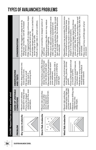
TYPES OF AVALANCHES PROBLEMS
CAUSE : Hazard from new snow and/or wind.
CONSIDERATIONS
• Can be naturally triggered in steep terrain by falling now, cornice fall, rock fall, increased wind and sun.
• Rider triggered sluffs on steep continuous slopes can accelerate fast and run far.
• Small slides dangerous when rider is carried into terrain traps or over cliffs.
• Sluffs can trigger slabs in certain conditions.
• Triggers on convexities or steepest section of start zone.
• Waiting several days after storm may reduce likelihood of triggering.
• When storm slabs exist in sheltered terrain wind slabs may also present in exposed terrain.
• As with all slab avalanches, the deeper the weak layer and larger the slope, the more destructive the avalanche.
• Deposition zones may accumulate 3-5x more snow than snowfall accumulation in sheltered areas
• Strong winds may result in deposition lower on slopes or in less typical locations.
• Riders commonly trigger slopes from thinner areas on either side or toe of wind slab.
• The wind drifting of dry, loose surface snow and subsequent avalanching can occur days after the last snowfall.
• New snow can bury and hide signs of prior wind event
OBSERVATIONS AND TESTS
SIGNS OF UNSTABLE CONDITIONS
• Boot deep penetration into loose surface snow.
• Recent point releases observed in steep terrain.
• Ski tests on small slopes result in accelerating sluffs.
• Forms a fan-shaped avalanche with fine, even sized debris.
• Hand hardness in profiles shows denser storm slab has formed over less dense weak layer.
• Decreased ski/foot penetration, snow cones illustrate recent snow settlement.
• Recent slab avalanches during or just after storm observed in steep sheltered terrain.
• Snowpack tests show slab is not bonding to underlying weak layer.
• Evidence of wind-transported snow (drifts, plumes, cornice growth).
• Snow surface rippled and crust or smooth and firm.
• Recent slab avalanches observed below ridge top, cornices and cross-loaded features.
• Once snow covered trees are now blown clean.
• Observe snow drifting near ridge lines onto steep slopes.
• Moderate or strong mountain wind speeds reported at weather stations
PROBLEM
Loose Avalanche
Dry
Slab Avalanche
Storm
Slab Avalanche
Wind
36 SILVERTON AVALANCHE SCHOOL
(...CONTINUED FROM PAGE 50)
• Cornices often break further back onto ridge top than expected.
• Observers may underestimate sun’s effect on the back of cornice when traveling on coll, shaded aspects.
• Cornice fall chunks may not look large but have significant mass and can be destructive or trigger slope below.
TYPES OF AVALANCHES PROBLEMS
CONSIDERATIONS
• No freeze for multiple nights worsens conditions. However, nighttime freeze can stabilize.
• Avalanches may start from rocks or vegetation.
• Can occur on all aspects on cloudy days/nights.
• Conditions may also include increased hazard from cornice fall, rockfall or icefall.
• Difficult to escape from loose wet or wet slab avalanches. Avoid terrain when wet conditions begin to penetrate into the snowpack.
• Loose wet conditions may lead to wet slabs.
• Shallow snow areas become unstable first and may slide to ground.
• Nearby glide cracks may be widening during rapid warming or rain event.
• Consequences of an avalanches in steep, confined or cliffy terrain increase as surface wetness penetrates deeper into the snowpack.
• Cornice growth after heavy snowfall or drifting snow.
• Cornice droop from sun.
• Watch for wind slab problem on slope below new cornice formation.
OBSERVATIONS AND TESTS
• Recent cornice fall.
Cornice Avalanche
• Cornice fall releases slab avalanches on slopes below.
CAUSE : Hazard from warming or rain.
SIGNS OF UNSTABLE CONDITIONS
• Wet snow surface from sun, heat or rain.
• Air temperatures at or above 0°C (32F.)
• Fan shaped avalanches with lumpy and chunky debris.
• Timing is critical: danger can increase quickly (minutes to hours.)
• Rain on snow, especially on dry snow.
• Pinwheels or roller balls.
• Avalanches may have rocks or dirt in debris.
• Deep foot penetration through wet surface snow.
• Snow profiles shows slab is at 0°C (32F) and/or weak layer below is wetted.
• Observe recent wet slab avalanches with debris that has channels/ridges, high water content. May entrain rocks and vegetation.
• Prolonged warming trend or rain, especially the first melt cycle on the dry snow.
PROBLEM
Wet Loose Avalanche
Wet Slab Avalanche
37 SILVERTON AVALANCHE SCHOOL
TYPES OF AVALANCHES PROBLEMS
CONSIDERATIONS
• Persistent weak layers can continue to produce avalanches for days or weeks making them especially dangerous and tricky to forecast.
• Despite no natural avalanches in observed area, persistent slabs may be triggered by the weight of a rider—particularly soft slabs (4F to 1F) that are <1m thick.
• Weak layer may have formed in select terrain or may be widespread. Multiple tests and expertise is required to identify extend and degree of hazard.
• A “stubborn” or sleeping deep weak layer may reactivate after new snow, drifting snow or warming.
• Deep slabs are difficult to forecast and manage. Large and/or historic avalanches may result. Avoid slopes with a known deeply buried and unstable layer.
• Deep slabs have been remotely triggered from shallower weak snowpack areas, from low on the slope, or from adjacent slopes.
• Observing and testing and weak layer deeper than 1m may be time consuming and strenuous.
• Unlikely to be human triggered and nearly impossible to forecast. Large destructive avalanches result.
• Often reoccur annually on the same, specific slope. This is the best clue. Avoid these slopes!
OBSERVATIONS AND TESTS
• Profiles reveal a soft coarse grained weak layer just above or below a firmer finegrained layer.
• advisories describe the weak layer as surface hoar, depth hoar or facets.
CAUSE : Hazard persists with old snow layers
SIGNS OF UNSTABLE CONDITIONS
• Advisories warn of persistent weak layer.
• Collapsing/whumping or shooting cracks from rider’s weight.
• The weak layer fractures cleanly across the column in snowpack tests.
• Warning: active avalanching may not be observed.
• Consider persistent slab conditions.
• Advisories warn of deep persistent slab problem.
• Snow profiles show increased depth of persistent layer.
• Despite a recognizable weak layer in snow profiles, column tests may not be conclusive.
• Recent but isolated large slab avalanche may indicate a sleeping problem is becoming active.
• No result from rider tracks but cornice fall triggers deep slab.
• When a glide slab releases other glide cracks nearby may also release.
• Continued snowfall loading event and/or a significant warming and/or rain event may release glide slabs.
• Observed slab release of the entire snow cover to the ground or to a near ground layer.
• Glide slabs often proceeded by widening of full depth “glide cracks” visible on surface.
PROBLEM
Persistent Slab Avalanche
Deep Slab Avalanche
Glide Avalanche
Ref: https://avalanche.state.co.us/forecasts/help/avalanche-problems
38 SILVERTON AVALANCHE SCHOOL
NORTH AMERICAN PUBLIC AVALANCHE DANGER SCALE
Avalanche danger is determined by the likelihood, size and distribution of avalanches.


Large avalanches in many areas; or very large avalanches in specific areas.
Likelihood of Avalanches
Avalanche size & Distribution 5 Extreme
Natural and human triggered avalanches certain.
Natural avalanches likely; human-triggered avalanches very likely.
Small avalanches in many areas or large avalanches in specific areas, or very large avalanches in isolated areas.
Small avalanches in specific areas; or large avalanches in isolated areas.
Small avalanches in isolated areas or extreme terrain.
Natural avalanches likely; human-triggered avalanches likely.
Natural avalanches unlikely; human-triggered avalanches possible.
Natural and human-triggered avalanches unlikely.
Avoid all avalanche terrain.

Large to very large avalanches in many areas. 4 High
Very dangerous avalanche conditions. Travel in avalanche terrain not recommended.
Dangerous avalanche conditions. Careful snowpack evaluation, cautious route-finding and conservative decision-making essential.
Heightened avalanche conditions on specific terrain features. Evaluate snow and terrain carefully; identify features of concern.
Generally safe avalanche conditions. Watch for unstable snow on isolated terrain features.
Safe backcountry travel requires training and experience. You control your own risk by choosing where, when and how you travel. No Rating
Watch for signs of unstable snow such as recent avalanches, cracking in the snow, and audible collapsing. Avoid traveling on or under similar slopes.

39 SILVERTON AVALANCHE SCHOOL
Danger Scale Travel
Advice
3 Considerable
2 Moderate
1 Low
AVALANCHE DESTRUCTIVE SIZE
Largest snow avalanche known. Could destroy a village or a forest area of 100 acres (40 hectares).
Could destroy a railway car, large truck, several buildings or a forest area of approximately 10 acres or (4 hectares)
Could bury and destroy a car, damage a truck, destroy a wood-frame house or break a few trees.
Could bury, injure or kill a person.
Relatively harmless to people. Can knock a person over.
Avalanche destructive scale size can also be recorded in half steps. Ref. SWAG Snow Weather Avalanche: Observation guidelines for Avalanche Programs in the United States.
40 SILVERTON AVALANCHE SCHOOL
Use these for discussion and building mental margins.
SNOWPACK: The Backcountry is always telling us a story. Are you listening?
• What is our greatest concern with the Snowpack today and are those problems Specific, Widespread or Isolated?
• How will the snowpack be influenced by today’s Weather forecast and will we see any Red Flags?
• What Risk Management Strategy is our current Snowpack allowing; Avoidance, Mitigation or Acceptance?
• Where, when and why would we dig in the snow today? What are we ground truthing?
• What snowpack observations would cause us to alter our plan, avoid more terrain, or turn around completely?
WEATHER: Nothing that happens quickly in the mountains is ever good!
• How will today’s Weather impact our Terrain choices and our Tour Plan?
• How will today’s Weather impact our Group Communication and Decision Making? Will it cause us to make poor decisions, take shortcuts or act impulsively?
• What if the Nowcast is better or worse than the Forecast?
• Do we anticipate today’s Weather causing us to observe and check any Red Flag boxes?
• What is our Field Weather Observations plan? Where, when and how often will we observe?
TERRAIN: When Stability and Safety is the question, Terrain is the Answer!
• Are we able to Reduce or Eliminate our Exposure today by utilizing Terrain to our advantage?
• Will we encounter slope angles between 30 and 45 degrees, Terrain Traps, Objective Hazards, Trigger Points, unavoidable crossings or obstacles, and how will we manage that?
• What Safe Travel Techniques and Avalanche Terrain Exposure Margins will our group employ today? How will the Terrain influence those on the way Up and Down?
• How will the Terrain impact our Group Communication and Decision Making?
• In the field, “What’s my Elevation? What’s my Aspect? Am I in or near Avalanche Terrain?”
HUMAN: In uncontrollable environments, control what you can control: Yourself!
• What are our individual and group goals for today? Do they align?
• What is an acceptable level of risk for you and your group today? Do they align?
• How will we make Group Decisions today? It takes “All to go, and one to NO!” How will we give every voice the space to be present and heard?
• What are you and your group’s non-negotiables and/or deal breakers?
• What are WE missing and/or assuming? What is YOUR gut saying? How does the plan make YOU feel?
TOUR PLAN: By failing to plan, you are planning to fail!
• When and Where are we meeting and how are we getting to the trailhead if it’s not there?
• Estimated time for all legs of our Tour Plan for the way Up and Down. Don’t forget to incorporate ample time for breaks, Group Communication and Decision Making!
• Decide a realistic Departure and Return time that all group members can agree on.
• Determine a No Later Than Turnaround Time for your group so you can return to the trailhead as agreed. Always allow ample time for things to go wrong in the descent!
• In the field: Ask yourself these three questions when you are facing uncertainty, “What can happen? How bad can it be? What do we do now?”
EMERGENCY RESPONSE PLAN: There’s never an always, and always a never!
• Does our whole team have Avalanche Rescue Gear including a Beacon, Shovel and Probe? Does everyone know how to use that gear?
• Who in the team has medical training(CPR, WFR, WFA, etc.) and who will be carrying medical resources(medical and/or trauma kit, medications, etc.)?
• Do we have means to call for Outside Help(cell, radio, sat phone, InReach, SPOT, etc.)?
• If we do not have means to call for Outside Help can we survive an incident with the gear we are carrying? Do we have enough food, repair items, means to transport a victim, the ability to make water, fire and shelter if needed?
• Do we have Ingress and Egress points for all locations in the tour plan in case of emergency? Who knows our plan and our return time?
41 SILVERTON AVALANCHE SCHOOL
42 SILVERTON AVALANCHE SCHOOL
43 SILVERTON AVALANCHE SCHOOL
44 SILVERTON AVALANCHE SCHOOL
NOTES:
THE AVALANCHE TRIANGLE
The outside of the avalanche triangle presents us with three, critical considerations—Snowpack, Weather and Terrain. All three of these considerations must be in play to produce an avalanche. Additionally, these focus areas are objective and observable. When we find instabilities and weaknesses in the snowpack, we note them. When it’s snowing, we see it. We measure slope angles and recognize avalanche terrain via steep slopes, convexities, vegetative clues and likely trigger points. This is all very objective information.

So if we can see all these problems and objectively call them out, why are riders still getting into trouble in the backcountry?
AT
THE CENTER OF THIS TRIANGLE IS US, THE HUMAN.
Humans are emotional, ego driven creatures. We see what we want to see. We often do what we want to do. But in terrain of consequence, that’s a dangerous approach to staying alive in avalanche terrain.
“The Ego is not your Amigo.”
Use the avalanche triangle to organize and reflect upon key considerations related to Snowpack, Weather, Terrain and Humans. The more information we have, the more informed actions, decisions and options we’ll have available to us.
SAS Recreational Level 1
Learning to Read the Story of the Winter Backcountry
SAS Recreational Level 2
RECREATIONAL
Learning to Lead in Avalanche Terrain
Avalanche Rescue
(25cm separation) Search strip width
Metal and/or electronics
ISBN 978-0-578-83709-3
9 780578 837093
90000>
SEND: 20cm distance; electronics ON SEARCH: 50cm distance; electronics OFF Search strip width