2 minute read
HURRICANE IAN BRINGS LESSONS


By Sept. 28, Ian barreled into Florida’s southwestern coast near Cayo Costa with lifethreatening storm surge — reaching an unprecedented 12 to 18 feet above ground level. Ian was the fifth-strongest hurricane to ever strike the U.S., and it was the first Category 4 hurricane to slam the southwestern parts of the state since Charley in 2004.
Heed Information From Trusted Sources
In the days before Ian traveled past Cuba and up the Gulf of Mexico, Florida Keys officials closely monitored forecasts from the National Hurricane Center while receiving daily reports from Jon Rizzo, warning coordination meteorologist with the National Weather Service in Key West. Ian’s eye passed over Dry Tortugas National Park as it tracked toward Florida, bringing hurricane-force gusts and storm surge to parts of the Lower Keys and Key West.
Assessments were bad, as Greg Barroso, Key West emergency management chief, witnessed Wilma-like damage from Ian with downed trees, blown-off manhole covers and standing water. City officials had concerns over where liveaboards and the homeless would seek shelter with the possibility of storm surge and gusty winds. Eventually, the Key West High School opened, where roughly 100 people rode out the storm.
Before the start of hurricane season, the Monroe County Tourist Development Council and Lodging Association of the Florida Keys and Key West convened an annual storm conference for the tourism industry. A panel composed of Jamie Rhone, NHC deputy director, Rizzo and Shannon Weiner, county emergency management director, discussed some of the lessons learned from Ian.
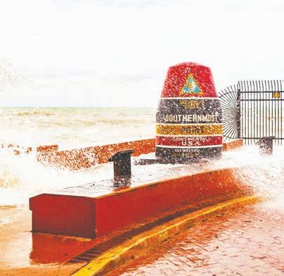
LargewavescrashovertheSouthernmostPointbuoy asHurricaneIanpassestothewestofKeyWest.LARRY BLACKBURN/Contributed
Rhone said there’s an overreliance on the track forecast cone, which represents the probable track of the storm’s center. As the NHC notes, the storm center doesn’t show the size of the storm. Hazardous conditions can occur outside of the cone, as evidenced by Ian’s wrath on Key West.
“The cone provides the high-level executive summary of where the storm is and the general direction it will go, and nothing more,” he said. “The hurricane warnings to tropical storm warnings are the premiere tools you should be using when a storm threatens.”
Rizzo said storm surge watches mean there’s a potential for life-threatening storm surge with a depth of 3 feet above ground level. A storm surge warning means there’s danger for rising, life-threatening water.
“We all probably think of ourselves as 5-foot-6-to-6-foot adults, but you gotta remember the children who live in the community — 3 feet is a direct threat to life. When it comes to a storm, heed the warning.”
More than anything, Rhone said people must stop shopping for forecasts on amateur websites and viewing models. Trust the forecast from the National Weather Service and National Hurricane Center.
“When you look at models online, you see 5-10% of what we see at the (NHC). Then we add our expertise on top of it. There’s nothing you can dig up on the internet that will allow you to be the official forecast from the National Weather Service,” he said.