FEATURE
Land use tug-of-war By Susan Drumheller Reader Contributor
Skip Lassen and Jenny Post, like many rural North Idaho residents, found their dream homes in the woods, miles from town. Lassen’s home is off the grid on 50 acres accessed by the private Coyote Trail road in the foothills of the Cabinet Mountains. Post lives nearby. Most of the land in the area is divided into 10-acre parcels and it’s all designated as Ag/Forest in the county’s comprehensive land use plan, which means properties cannot be subdivided into parcels smaller than 10 acres. “I live 20 miles out for a reason,” Lassen said. “I don’t live out there for increased population density.” So when a nearby landowner applied to Bonner County to divide a 20-plus-acre lot into five-acre parcels, Lassen and Post and the other neighbors were concerned. They worried about traffic on their road and increased fire danger, as the area is largely forested. “That’s our Achilles heel up here, it’s fire danger,” Post said. “It’s a tinderbox,” Lassen said. “You increase density and your fire danger goes up.” Despite the concerns of several neighbors, the county planning staff recommended amending the comp plan and zoning to allow the higher density. The request was unanimously approved by both the Planning and Zoning Commission and the board of commissioner in the fall. “It was like they were going through their perfunctory role, listened to the objections and they dismissed it,” said Lassen who attended the P&Z hearing. Rural stewards About the same time, a group of Selle Valley volunteers were wrapping up three years of meetings on a comp plan update for the Selle Valley and Samuels area. Like other “subarea” plans 16 /
R
/ March 4, 2021
around the county, the committee made it clear their intent was to protect their rural quality of life. The process began with a couple of rowdy community meetings three years ago at Northside Elementary School. “The people were yelling, ‘Leave it [the valley] alone! We don’t want to change anything,’” recalled Fred Omodt. Omodt later became chair of the Selle-Samuels Subarea Plan Committee, convened by the county to review the comp plan and recommend changes to meet the needs and desires of the rural community. The county comp plan is the guiding document for growth and land use in the county, setting the overarching goals and objectives. The county’s zoning codes are the laws that carry out the intent of the plan. The comp plan and land use map were last updated in 2005. Before the update, most of the county’s land use was designated Rural Residential, which meant that lots in those areas could be as small as five acres. The county hired planning consultants who hosted community meetings in which residents voiced concerns about sprawl, strip development and leap-frogging growth, according to a 2005 story in the Spokesman-Review. The county responded by changing the land use designation for much of the outlying rural areas to Ag/Forest — with 10-acre lot minimums. Judging from the work of the subarea plan committees around the county, that’s something they want to see maintained. “I know there’s a demand to be up in this area,” said Doug Gunter, a member of the Sagle Subarea Plan Committee. “We want to keep Sagle rural as much as possible.” Gunter describes himself as an “old Sagle farm boy.” His grandfather was born in a wall tent on the homestead off Sagle Road, where Gunter raised his
Neighborhood winners and losers
4-H steers, and he wants the same rural lifestyle for his own three children. Gunter’s uncle and father were involved in crafting earlier versions of the county’s comp plan. Gunter attended the initial Sagle subarea meetings, because it was his turn to defend the rural lifestyle from the inevitable growth that was coming. At the large community meetings at Sagle Elementary School in 2016, he found his neighbors largely agreed with
his point of view. “It was undeniable what 90% of the people wanted,” he said. But he questions if county leadership shares those desires.
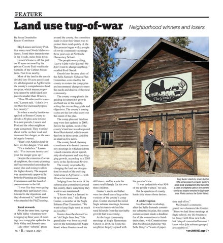
Doug Gunter stands by a barn built in 1950 on his property in Sagle. Gunter’s great-great-grandparents first moved to a cabin by Shepherd Lake in 1914 and the family has largely remained in Sagle ever since. Photo courtesy the Gunter family.
A cold reception In a December workshop, after the Selle-Samuels committee submitted its plan, the county commissioners made a deadline for all the committees to finish their plans, with Commissioner Dan McDonald declaring “the Selle thing” a “waste of paper,
time and effort.” McDonald’s comments grated on volunteers like Gunter: “Since we had those meetings at Sagle school, my life became a lot busier with three new kids, but I stayed committed because I know what [the subarea groups] are capable of.” < see LAND USE, page 17 >