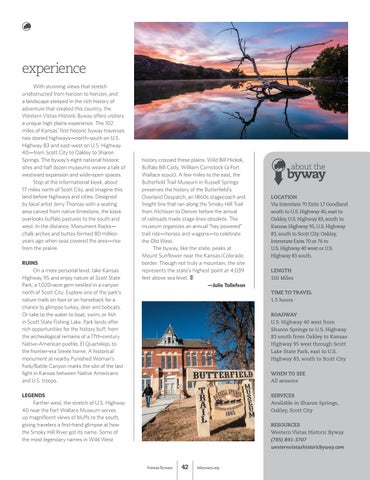
experience With stunning views that stretch unobstructed from horizon to horizon, and a landscape steeped in the rich history of adventure that created this country, the Western Vistas Historic Byway offers visitors a unique high plains experience. The 102 miles of Kansas’ first historic byway traverses two storied highways—north-south on U.S. Highway 83 and east-west on U.S. Highway 40—from Scott City to Oakley to Sharon Springs. The byway’s eight national historic sites and half dozen museums weave a tale of westward expansion and wide-open spaces. Stop at the informational kiosk, about 17 miles north of Scott City, and imagine this land before highways and cities. Designed by local artist Jerry Thomas with a seating area carved from native limestone, the kiosk overlooks buffalo pastures to the south and west. In the distance, Monument Rocks— chalk arches and buttes formed 80 million years ago when seas covered the area—rise from the prairie. RUINS On a more personal level, take Kansas Highway 95 and enjoy nature at Scott State Park, a 1,020-acre gem nestled in a canyon north of Scott City. Explore one of the park’s nature trails on foot or on horseback for a chance to glimpse turkey, deer and bobcats. Or take to the water to boat, swim, or fish in Scott State Fishing Lake. Park lands offer rich opportunities for the history buff, from the archeological remains of a 17th-century Native-American pueblo, El Quartelejo, to the frontier-era Steele home. A historical monument at nearby Punished Woman’s Fork/Battle Canyon marks the site of the last fight in Kansas between Native Americans and U.S. troops.
history crossed these plains: Wild Bill Hickok, Buffalo Bill Cody, William Comstock (a Fort Wallace scout). A few miles to the east, the Butterfield Trail Museum in Russell Springs preserves the history of the Butterfield’s Overland Despatch, an 1860s stagecoach and freight line that ran along the Smoky Hill Trail from Atchison to Denver before the arrival of railroads made stage lines obsolete. The museum organizes an annual “hay powered” trail ride—horses and wagons—to celebrate the Old West. The byway, like the state, peaks at Mount Sunflower near the Kansas-Colorado border. Though not truly a mountain, the site represents the state’s highest point at 4,039 feet above sea level. —Julie Tollefson
about the
byway LOCATION Via Interstate 70 Exits 17 Goodland south to U.S. Highway 40, east to Oakley, U.S. Highway 83, south to Kansas Highway 95, U.S. Highway 83, south to Scott City. Oakley, Interstate Exits 70 or 76 to U.S. Highway 40 west or U.S. Highway 83 south. LENGTH 102 Miles TIME TO TRAVEL 1.5 hours ROADWAY U.S. Highway 40 west from Sharon Springs to U.S. Highway 83 south from Oakley to Kansas Highway 95 west through Scott Lake State Park, east to U.S. Highway 83, south to Scott City WHEN TO SEE All seasons
LEGENDS Farther west, the stretch of U.S. Highway 40 near the Fort Wallace Museum serves up magnificent views of bluffs to the south, giving travelers a first-hand glimpse at how the Smoky Hill River got its name. Some of the most legendary names in Wild West
SERVICES Available in Sharon Springs, Oakley, Scott City RESOURCES Western Vistas Historic Byway (785) 891-3707 westernvistashistoricbyway.com
Kansas Byways
42
ksbyways.org