JOSHUA GILLELAND
PORTFOLIO LANDSCAPE ARCHITECTURE


Thank you for taking the time to view my portfolio.
I will be featuring a number of projects that I have designed while at Washington State University studying Landscape Architecture. These projects are the best reflections of the skills I have developed in school and represents work that demonstrates my readiness for a professional setting. It also demonstrates my capability of working the process of a design from start to finish and ability to address and solve problems on project sites.
My personal taste and values in landscape architecture are very meaningful to me. Therefore, this portfolio emphasizes these values to express my truest self and why I believe what I design is important.
I have always been a fan of two things: designing, and the outdoors. It wasn’t until I attended college that I was introduced to landscape architecture, and I instantly knew it was the path for me. Studying in this field has widely grown my knowledge in many subjects, such as horticulture, ecology, soil science, GIS, and graphic/digital design. I am extremely excited for whatever path I choose next in learning and growing even more as a landscape architect. Thank you once again for your time and enjoy my work.
Joshua Louis Gilleland
Phone Number: (509) 699-3366
Gmail: joshuagilleland01@gmail.com
School Email (Preferred): joshua.gilleland@wsu.edu


Washington State University- BA- Landscape Architecture
Software Skills: Photoshop InDesign QGIS SketchUp Rhino 3D AutoCAD


A redesign of downtown Pullman, Washington that creates a more equitable space for pedestrians and natural elements.


Pg. 3-6
A mixed-use recreational space that revitalizes and brings back identity to the small town of Malden, Washington.

Pg. 7-9
A graphic chronological analysis of ecological progressions within two national forests in Washington state.
Pg. 10-12
A reimagination of an abandoned mall site into a diverse multi-use complex within Washington’s Skagit Valley.
Pg. 13-16


Located in Pullman, Washington, Downtown Collective imagines a new functionality of the city’s downtown, and reutilizes different areas to benefit lacking programs in a carfocused and dependent downtown landscape. The design influences these programs to enhance different user experiences and allow a more equitable and sustainable space for the future. Downtown Collective works to benefit the pedestrian user by expanding sidewalks and plaza space by reducing roads and parking lots on the site. Installed natural
programs such as rain gardens and a constructed wetland will work to remediate rain and flooding events on the impervious surfaces and bring additional natural elements to downtown. A new trolley system will adaptively reuse an old railway moving near the site and provide a better connection with the nearby Washington State University Campus. Other site elements, such as a food truck court and viewing platform, provide additional attraction for users to visit and enjoy themselves within the Downtown Collective.


 Looking South/Southeast from trolley boarding area towards plaza area, constructed wetland, and main street.
Looking West along expanded sidewalk viewing main street, trolley boarding area, wetland, and plaza area.
Looking South/Southeast from trolley boarding area towards plaza area, constructed wetland, and main street.
Looking West along expanded sidewalk viewing main street, trolley boarding area, wetland, and plaza area.
Legend
1. Expanded Sidewalks
2. E Main Street (Reduced from 3 to 2 lanes)

3. Rain Gardens
4. Constructed Wetland
5. Viewing Platform over Wetland
6. Food Trucks/Court
7. Plaza Areas
8. Trolley Waiting Platform
9. Railway
DOWNTOWN PULLMAN
Master Plan Boundary
Expanded Sidewalks/Rain Gardens Continued
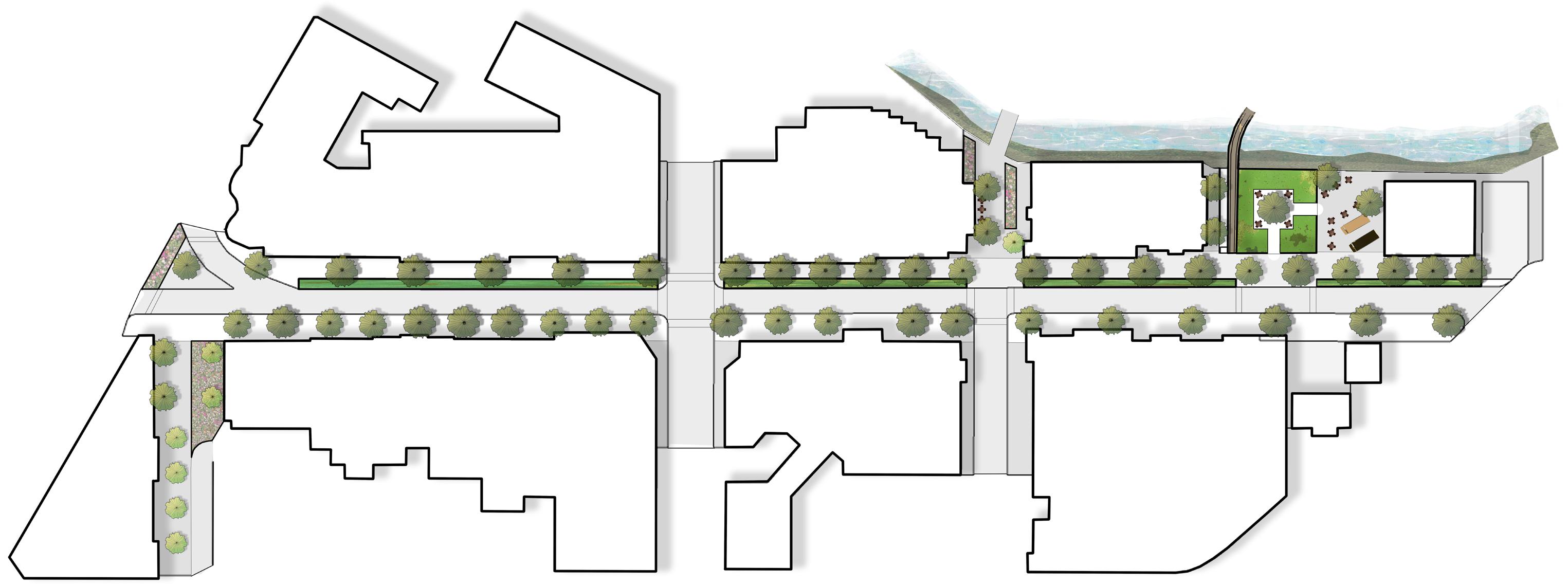

Section Line A (Next Page)
Section Line B (Next Page)


Bioretention/Collection Areas


Water Systems/Flow Directions

Rain Gardens will retain rainwater collected from the road and sidewalks downtown, while the constructed wetland will work as an overflow collection basin for the river in extreme situations of high rain/flooding


Access to Economic Infrastructure (Stores, Restaurants, etc.)
INTEGRATION
The expansion of downtown Pullman’s sidewalks provides a safer and more enjoyable experience for pedestrians to explore downtown and its many businesses, bringing more economical benefits to said businesses.
Rail Circulation
WSU Pullman Campus
Downtown Pullman
Downtown Railway Stop Campus Railway Stop (Elson S. Floyd Cultural Center)
The trolley system is designed to connect downtown Pullman with WSU’s campus and integrate the two spaces. The rail will primarily move along an old unused train track inbetween downtown and a station at the Floyd Cultural Center.


Located in Malden, Washington, the Pine Creek Recreational Area is a mixed-use outdoor space that provides an abundance of recreational activities for the community and surrounding region. Consisiting of nearly one-hundred acres, much of the site is dedicated to preserving the natural landscape with sustainable methods of construction that have both a minimal impact on the local environment and a low-carbon footprint. Pine Creek Recreational Area has the main goal of restoring the community of Malden and the surrounding region, which was severely affected by a wildfire in 2020. A restoration of the Pine Creek watershed, which runs through the site, will work to reestablish a biodiverse
riparian ecosystem that can work to prevent erosion and severity of future wildfires. Established camping areas and mixed-use trails will provide tourism and economic growth which can go towards redevelopment to pieces of the community destroyed in the fire. The site provides activities for people across many kinds of recreation, from cyclists looking to ride designated mountain biking trails, to through-hikers on the Palouse to Cascades Trail looking for camping and similar amenities. Additionally, a plaque dedicated to the indigenous history of the region as well as those who helped build back from the wildfire will overlook Pine Creek and much of the site.

 Typical unidirectional mountain biking trails prevent accidents and enhance user experience.
Looking Northeast along Palouse to Cascades Trail viewing RV camping area and connecting trail to bath house and parking area.
Typical unidirectional mountain biking trails prevent accidents and enhance user experience.
Looking Northeast along Palouse to Cascades Trail viewing RV camping area and connecting trail to bath house and parking area.
Legend
1. RV Camping/Parking Area (See Enlargement B)
Overview of Pine Creek Recreational Area, indicating locations of enlargements and details of main site programs, as well as additional features and programs present on the site.

NEZ PERCE/FIRE MEMORIAL PLAQUE
2. Nez Perce/Fire Memorial Plaque (See Enlargement A)
3. Tent Campgrounds
4. Ecological/Habitat Restoration Areas (See Detail B)
5. Viewing Platforms
6. Footbridges
7. Pine Creek
Main Bike Route Path (See Detail A)
Alternative Bike Route Paths Walking Paths
Legend
1. Main Walking Path
2. Main Bike Route Path

3. Plaques and Overlook
Legend
1. Site Entrance/Exit (To Malden)

2. Palouse to Cascades Trail
3. RV Camping Area
4. Restroom/Bath House
5. Open Grass/Picnic Area
6. Parking Area
7. Trail Access to Tent Camping and Bike Trails
Section A
Beaver Habitat Influence
Introducing beavers into the Pine Creek watershed can help promote biodiversity, increase wetlands and water storage, and protection against erosion and wildfires.
Riparian Zone of Influence Restoration Plants


Trees: Ponderosa Pine-Pinus ponderosa, Black Cottonwood-Populus trichocarpa

Riparian Zone Restoration Plants
Trees: Black Cottonwood-Populus trichocarpa, Quaking Aspen-Populus tremuloides, Hawthorn-Crataegus sp.
Shrubs: Coyote Willow-Salix exigua, Bebb’s Willow-Salix babbiana, Western Spiraea
-Spiraea douglasii, Golden Currant-Ribes aureum, Chokecherries -Prunus virginiana

The State of Washington has one of the most ecologically diverse ranges of forests in the United States. From temperate rainforests within the Olympic Peninsula, to a vast evergreen forest covering the Cascade region, many different forest ecologies are present within the state. These ecosystems vary significantly in many different things, such as fauna, flora, precipitation rates, and soil composition. These factors contribute to the 2
how these ecologies grow and become more biodiverse overtime. This project will observe 2 forest landscapes of Washington with progressive ecological sections. The sections will demonstrate a particular ecology from its early and barren stages all the way to its later and biodiverse stages. The increased growth of plant and animal species will also be demonstrated to represent the increase in biodiversity.
OKANOGAN-WENATCHEE
NATIONAL FOREST
Landscape is mostly barren with some plant species and no animal species. Soil has not established well enough to provide sustenance for significant ecological growth.

Soil begins to develop more fertility quickly due to heavy rainfall. As resources increase, many plant and some small animal species begin to establish in the ecosystem.


Landscape has a diverse array of plant species. Animal species begin fully establishing by way of access to more food and habitat from large growth of plant species.


Landscape becomes a fully biodiverse ecosystem. Plant and animal species thrive, work together, and give each other optimal resources for survival.

Soil Type
Clay Loam – 70% clay, 10% sand, 20% silt


Water Level – 190-210 in. rain per year
Located entirely on the Olympic Peninsula, the Olympic National Forest is one of the largest and ecologically diverse forests in Washington. Much of the forest is classified as a temperate rainforest, seeing over two-hundred inches of rain annually, making it the rainiest forest in the contiguous United States. This unique landscape is home to a vast array of plant and animal species that have lived there for centuries.
Spike Moss Selaginella Lettuce Lichen Lobariaoregana Douglas Fir Pseudotsugamenziesii Western Redcedar Thujaplicata Sitka Spruce Piceastichensis Western Sword Fern Polystichummunitum Licorice Fern Glycyrrhizaglabra Broadleaf Lupine Lupinuslatifolius American Black Bear Ursusamericanus Raccoon Procyonlotor Black-Tailed Deer Odocoilleuscolumbianus Northern-Spotted Owl Strixoccidentaliscaurina Raven Corvuscorax Pacific Tree Frog Pseudacrisregillaarray of tree and shrub species, as well as habitats for numerous native animal species . Gifford Pinchot National Forest is one of many National Forests in Washington and stretches over 1.3 million acres within the state.

Year 5
Landscape starts off with mostly grasses and low-growing vegetation. As soil begins to establish fertility, tree saplings begin to sprout and grow.

Forest landscape starts off with mostly grasses and lowgrowing vegetation As soil begins to establish fertility, tree saplings begin to sprout and grow
Saplings sprout up throughout forest and grow quickly. Other plant species grow and diversify as well, and small nesting animal species begin to populate.


Saplings sprout up throughout forest and grow quickly Other plant species grow and diversify as well, and small nesting and burrowing animal species begin to populate.


Forest starts to become a diverse landscape, with soil becoming very well established. Some tree and other plant species reach mature height and spread.
Forest starts to become a diverse landscape, with soil becoming very well established . Some tree and other plant species reach mature height and spread.


Landscape becomes a fully biodiverse ecosystem. Plant and animal species thrive and work together, giving each other optimal resources.


Forest landscape becomes a fully biodiverse ecosystem Plant and animal species thrive and work together, giving each other optimal resources .

Soil Type
Silty Clay Loam – 20% sand, 40% silt, 40% clay
Silty Clay Loam – 20% sand, 40% silt, 40% clay
Water Level – 90-120 in. rain per year
Water Level – 60-110 in. rain per year
Spanning over 3 million acres, the Okanogan-Wenatchee National Forest is the largest forest in Washington, and one of the largest in the United States. The forest stretches over a majority length of the state, and displays a wide array of tree and shrub species, as well as habitats for numerous native animal species.
Skagit Gardens reimagines the former site of the Cascade Mall in Burlington, Washington. Like many malls in the United States, the Cascade Mall slowly fell out of relevancy, and needed to close its doors. Skagit Gardens reclaims the lot of this mall and returns it to a more natural, inclusive, and comprehensive space that supports more relevant programs and needs. Skagit Gardens contains numerous new design programs that connect to create a unified and cohesive space. A farmer’s market and
many gathering/recreational spaces support the culture and community of the surrounding Skagit Valley, while a garden using old vehicles as plant beds provides a place for art and tourism opportunities. The constructed wetland and bird sanctuaries restore natural elements to the site and help alleviate chronic flooding issues in the area. Lastly, a variety of residential buildings will help contribute to supporting local residents with an exciting and sustainable place to live.


 Looking Southeast towards greeting fountain and main entrance.
Looking Southeast towards car garden art display and residential building.
Looking Southeast towards greeting fountain and main entrance.
Looking Southeast towards car garden art display and residential building.


LOOKING NORTH
These sections show the flow of different design elements moving West to East along Skagit Gardens. The design’s constructed wetlands and ponds will be dug into the ground, both native and non-native plants to the Skagit Valley will be used on the site to help restore the site to its natural form as well as remediate flood-related issues on the site.

Natural woodland and bird sanctuaries will be separated from spaces where people will be active to preserve a space for both groups to thrive. Louder and quiter spaces are also separated to create areas for people’s preference and well-being.
 Natural Woodland Wetland Pathways Fishing Pond Pathways Utility Road Farmer’s Market Main Walkway Sculpture Park Wetland Parking
Natural Woodland Wetland Pathways Planting Bed Wetland Boardwalk Pathway Building
Natural Woodland Wetland Pathways Fishing Pond Pathways Utility Road Farmer’s Market Main Walkway Sculpture Park Wetland Parking
Natural Woodland Wetland Pathways Planting Bed Wetland Boardwalk Pathway Building
201 CASCADE MALL RD. BURLINGTON, WA, 98233
These diagrams provide better context for the current site of Skagit Gardens and the surrounding area.

The site context map demonstrates the site currently being dominated by the Cascade Mall with only a few small restaurants and businesses being the other structures on the site. Additionally, very little landscaping and a large amount of parking lots are present on the site.
The regional context map provides a better perspective of the site within Burlington. The site is in an urban setting and is surrounded by many commercial and residential hubs.


