DW101-150 Listing.qxp_Layout 1 24/03/2016 15:19 Page 54
203 France. Ortelius (Abraham), Galliae Veteris Typus, [1595 or later], uncoloured engraved map, 395 x 485mm, together with another seven maps of Franch regions, with examples by De L’Isle and Albrizzi, various sizes and condition
207 Gloucestershire. A mixed collection of approximately twentyone maps and topographical views, mostly 18th & 19th century, engravings and lithographs, including county maps by Moule, Luffman (3 examples), Seller/Grose, Owen & Bowen, Aiken, and Van Langeren, town plans of Cheltenham by Lee, Henry James, Lewis and A & C Black, and lithographic and etched views by Rowe, Shaw, Egerton and Wallace Hester, various sizes and condition
The first map described. Marcel van den Broecke. Ortelius Atlas Maps no.196. £120-180 (8)
204 France. A mixed collection of eighteen maps, 16th - 19th century, engraved regional and country maps, several with contemporary hand colouring, including examples by Cary, Weigel, Blaeu, Sanson, Jaillot, Faden, Hondius, Ortelius, Jansson and Fabert, occasional duplicates, various sizes and condition (18)
(21)
208 Huntingdonshire. Speed (John), Huntington Both Shire and Shire Towne with the Ancient Citie Ely described, published Roger Rea, circa 1662, uncoloured engraved map, inset town plans of Huntingdon and Ely, slight spotting, small library blind stamp to margin, very slight staining, some marginal closed tears, 385 x 510mm, English text on verso
£200-300
205 Germany. A mixed collection of forty maps, 17th - 19th century, engraved town plans, regional and country maps, several with contemporary hand colouring, including examples by Faden, Boeckel, Rollos, Bowen, Blaeu, Kitchin, Stockdale, Moll, Zatta, Williams, Bonne, Cary, Wells and Rizzi-Zannoni, occasional duplicates, various sizes and condition (40)
(1)
£70-100
209 Huntingdonshire. Speed (John), Huntington both Shire and Shire Towne with the Ancient Citie Ely Described, published Roger Rea, circa 1662, hand coloured engraved map, inset town plans of Huntingdon and Ely, central fold strengthened on verso, one small closed tear affecting image, 385 x 510mm, English text on verso
£200-300
(1)
£70-100
210 Isle of Man. Speed (John), The Isle of Man exactly described and into Several Parishshes divided and with every Towne, Village, Baye, Creke and River therein conteyned. The bordringe Coasts wherewith is circulated in their situations sett and by the Compase accordigly shewed, with their true distance from every place into this Island by a severall scale observed, published Roger Rea, circa 1662, uncoloured engraved map, two large strapwork cartouches, compass rose and numerous rhumb lines, occasional small marginal closed tears not affecting image, small library blind stamp in margin, 385 x 510mm, English text on verso
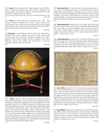
206* Globe. Newton (J & W., manufacturer), Newton’s New & Improved Celestial Globe, on which all the Stars Nebulae & Clusters contained in the extensive Catalogue of the late F. Wollaston F.R.S. are accurately laid down, their Right, Ascensions & Declinations having been recalculated for the year 1830, by W. Newton Manufactured by J. & W. Newton, 66 Chancery Lane London Published 1st July 1824, twelve inch celestial table globe, twelve engraved gores with contemporary hand colouring, calibrated brass meridian ring, wooden horizon ring with paper overlays, paper worn and chipped with slight loss, lacking upper hour circle, globe with long crack around the equator, crudely repaired, gores toned and dust soiled, some surface chipping and abrasion, presented on a contemporary turned wooden ‘tripod’ stand with stretchers, height 500mm (1)
£150-200
(1)
£200-300
211 Isle of Wight. Speed (John), Wight Island, published Roger Rea, circa 1662, uncoloured engraved map, inset town plans of Newport and Southampton, some creasing, central fold split and crudely repaired on verso, repaired marginal closed tears, slight staining largely confined to margins, one library blind stamp to margins, 385 x 510mm, English text on verso (1)
£500-800
54
£70-100