DW101-183 Part One.qxp_Layout 1 01/12/2017 14:27 Page 35
Lot 106
Lot 108
106 British Isles. Fries (Lorenz), Tabu Moder Anglie & Hiber, published Strasburg, [1535], uncoloured woodblock map, slight damp staining to upper margin, 330 x 410mm, no text to verso R. W. Shirley. Early Printed maps of the British Isles, 1477 - 1650, no. 25. Published by Melchior and Gaspar Treschel this was a re-working of the Ptolemy & Waldeseemuller map of 1522, but with Scotland now ‘upright’ and with the appearance of the mythical island of Brazil off the western coast of Ireland. (1) £800-1200
107 British Isles. A mixed collection of 52 maps, 19th century, engraved and lithographic maps of England & Wales and the British Isles, many with hand colouring, including examples by Dower, Findlay, Lowry, Houze, Williams, Archer, Thierry, Morse, Hall, Bruckner, Malte-Brun, Scott, Dufour, Hamm, Cobbett, Arrowsmith, Ewing, Becker, Darton, Wilkinson and Cary, contained in a modern ring binder, various sizes and condition (52)
£100-200
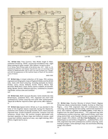
108 British Isles. Bellin (Jacques Nicolas), Carte reduite des Isles Britanniques, published Paris, 1757, engraved sea chart with contemporary outline colouring and some later enhancement, ‘Depot de la Marine’ imprint to lower right corner, 880 x 560mm (1)
Lot 109
110 British Isles. Visscher (Nicolas & Schenk Pieter), Magnae Britanniae tabula comprehendens Angliae, Scotiae ac Hiberniae Regna..., circa 1720, engraved map with contemporary hand colouring, some staining and dust soiling, central fold repaired on verso, 470 x 565mm, together with Senex (John), A New Map of England from the latest observations..., 1721, engraved map with contemporary outline colouring, slight overall toning, small hole along central fold, some fraying to borders causing slight loss to lower margin, 515 x 615mm, with De L’Isle (Guillaume), Les Isles Britanniques ou sont le Rme. d’Angleterre..., published Paris, circa 1745, engraved map with contemporary outline colouring, some fraying to margins, some staining to map, two wormholes affecting image, 475 x 615mm
£150-200
109 British Isles Speed (John), Britain as it was devided in the tyme of the Englishe Saxons especially during the Heptarchy, published John Sudbury & George Humble, [1627], hand coloured engraved map, ornate strapwork cartouche, compass rose and numerous rhumb lines, the vertical margins decorated with fourteen vignettes of Saxon kings and historical scenes, small closed tear skillfully repaired on veso, very slight staining, 380 x 510mm, English text to verso (1)
£800-1200
(3)
35
£100-150