DW101-174 Listing Pt. 1.qxp_Layout 1 02/06/2017 15:48 Page 37
115 Shipton (Ursula, Mother). The Strange and Wonderful History and Prophecies of Mother Shipton, printed by J. Kendrew, Colliergate, York, 1809, 24pp., woodcut illustration to title and four woodcut illustrations to text (illust. to p. 11 faint), small hole to p. 19/20 slightly affecting text, some dust-soiling and creasing, edges untrimmed, unbound as issued, 12mo (Scarce Yorkshire chapbook. Five UK locations only), together with Smith (J. Fred), A Letter to the Electors of Wakefield, on the Present Crisis, more Especially those who are Working Bees, the Real ‘Leading Interests’ of the Hive, Wakefield: Printed by James Nichols, 1834, 56pp., dustsoiled, later limp wrappers (loose), slim 8vo, with Banks (William Stott), A List of Provincial Words in use at Wakefield in Yorkshire..., 1865, original printed wrappers, dust-soiled, small 8vo, and The Yorkshire Dalesman, A Monthly Magazine of Dales’ Life and Industry, edited by Harry J. Scott, volumes 1-5, (in 60 original parts), April 1939-March 1944, black & white illustrations, original printed wrappers, slim 8vo, contained in two purpose made leather slipcases, plus a large aquantity of other Yorkshire related pamphlets, mostly 19th & early century (2 cartons)
£150-250
117 Speed (John), York Shire, published John Sudbury & George Humble, [1627], hand coloured engraved map, split at base of central fold, repaired on verso, slight mount staining, 385 x 510mm, English text on verso (1)
£150-200
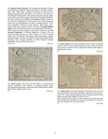
116 Speed (John), The North and East Ridins of Yorkshire, 1st edition, published John Sudbury & George Humble, [1611], uncoloured engraved map, inset town plans of Richmond and Hull, 390 x 515mm, English text on verso (1)
118 Speed (John), The West Ridinge of Yorkshyre with the most famous and fayre Citie Yorke described, published C.Dicey & Co., circa 1770, hand coloured engraved map, inset town plan of York, slight creasing, 385 x 505mm, no text on verso
£200-300
Dicey produced the last edition of John Speed’s maps almost 160 years after they were first published. The maps were chronically out of date and didn’t sell making this an uncommon edition. (1) £150-200
37