155
F. Finsen et al.
|
Using radar altimetry to update a large-scale hydrological model
Hydrology Research
|
45.1
|
2014
In this formula, Qass is the analysed discharge, Qsim is the
between the altimetry water level time series and the in-situ
simulated discharge prior to assimilation, Qalt is the dis-
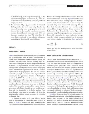
water level time series is very high. Figure 4 shows the delay
charge estimate based on altimetry and G is a gain factor
times between the various altimetry targets and the Baha-
ranging from 0 to 1.
durabad in-situ station as a function of river chainage. As
3. The innovation GðQalt Qsim Þ is added to the simulated
expected, delay times increase with increasing distance
discharge at the river node representing the altimetry
from the in-situ station. Kinematic wave celerities can be
target. All updating terms are propagated to the next
extracted from the graph for three distinct sections of the
time step but are discounted in each time step using a
Brahmaputra River. Given that the friction slope can be
constant discount factor δ, which was set to 0.975 per
expressed using Manning’s equation and assuming a uni-
time step, using daily time steps. This value of the dis-
form, wide rectangular flow cross section, the average
count factor was found by trial-and-error adjustment,
water flow velocity (vw) can be estimated from the kinematic
maximizing the Nash–Sutcliffe model efficiency.
wave celerity (ck) using the formula (e.g. Chow et al. ):
vw ¼
RESULTS
3 dQ 3 ¼ ck 5 dA 5
(5)
where Q is the river discharge and A is the flow cross-
Radar altimetry findings
sectional area.
Table 1 summarizes the characteristics of the virtual stations
Model calibration and validation results
on the Brahmaputra River. 17 ERS-2 virtual stations, 6 Topex virtual stations and 10 Envisat virtual stations are
The total model simulation period extends from 2000 to 2010.
available. The first column gives the altimetry target ID.
However, in-situ data are only available for the period 2005 to
The second column gives the relative overpass time, relative
2010. The period with available in-situ data was split into a
to the first ERS target (B-ERS-1). The third column gives the
calibration period (2005–2007) and a validation period
chainage of the altimetry target relative to the in-situ gauging
(2008–2010). The model was calibrated against the observed
station Bahadurabad. Negative numbers indicate a location
discharge at the Bahadurabad, Nuxia and Nugesha stations
upstream from the gauging station. The next two columns
for the 3-year calibration period. In total, 12 parameters were
contain the geographic coordinates of the targets. The next
automatically calibrated (6 for the upstream and 6 for the
column gives the approximate elevation of the target as
downstream portions of the basin) using a trust region reflec-
read from the SRTM. The next three columns contain the
tive algorithm (Coleman & Li ), which outperforms the
fitted delay time and its lower and upper confidence interval
Levenberg–Marquardt algorithm if the initial parameter esti-
bounds. The final column contains the maximum achieved
mates are far from the optimum. The calibration objective
correlation between the altimetry target and the discharge
function was the root mean square error (RMSE) of simulated
station. This correlation is achieved for a delay time as
versus observed discharge. The upstream portion of the basin
given in the table. Targets shaded in grey are considered out-
was calibrated using the stations Nuxia and Nugesha, which
liers and were disregarded in the further analysis. They
were equally weighted in the calibration. The downstream por-
generally show a low degree of correlation with the in-situ
tion of the basin was calibrated using the Bahadurabad station.
gauging station and some of them are located on tributaries to the main river.
Table 2 provides an overview of the calibration parameters and the calibrated parameter values. Calibration parameters
To illustrate the quality of the radar altimetry targets
included four parameters of the Budyko rainfall–runoff
over the Brahmaputra, an example for target B-ERS-10 is
model (α1, α2, d and Smax), as well as two Muskingum routing
shown in Figure 3. Although the target is located about
parameters (vmax and X ). Generally, post-calibration par-
320 km upstream from the Bahadurabad station, correlation
ameter confidence intervals are reasonably confined, except