Chapter 3. Spatial referencing and satellite-based positioning can use the monument of the triangulation network that is closest to the new point. The extension and re-measurement of the network is nowadays done through satellite measurements.
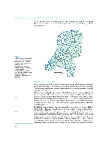
Amersfoort Figure 3.6 The old primary triangulation network in the Netherlands was made up of 77 points (mostly church towers). The extension and re-measurement of the network is done nowadays through satellite measurements. Adapted from original figure by “Dutch Cadastre and Land Registers�, now called het Kadaster.
0
50 km
The global horizontal datum With increasing demands for global surveying, activities are underway to establish global reference surfaces. The motivation in this is to make geodetic results mutually compatible and to be able to provide coherent results to other disciplines, e.g. astronomy and geophysics.
ITRS
ITRF
98
The most important global (geocentric) spatial reference system for the geoinformation community is the International Terrestrial Reference System (ITRS) . This is a threedimensional coordinate system with a well-defined origin (the centre of mass of the Earth) and three orthogonal coordinate axes (X, Y, Z ). The Z -axis points towards a mean North Pole. The X -axis is oriented towards the mean Greenwich meridian and is orthogonal to the Z -axis. The Y -axis completes the right-handed reference coordinate system (Figure 3.7a). The ITRS is realized through the International Terrestrial Reference Frame (ITRF), a distributed set of ground control stations that measure their position continuously using GPS (Figure 3.7b). Constant re-measuring is needed because of the addition of new control stations and ongoing geophysical processes (mainly tectonic plate motion) that deform the Earth’s crust at measurable global, regional and local scales. These deformations cause positional differences over time and have resulted in more than one realization of the ITRS. Examples are the ITRF96 and the ITRF2000. The ITRF96 was established on 1 January 1997, which means that the measurements use data acquired up to 1996 to fix the geocentric coordinates (X , Y and Z in metres) and velocities (posi-