3.1. Spatial referencing Ellipsoid globally best fitting to the geoid
Region of best fit
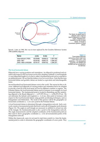
Figure 3.5
Ellipsoid regionally best fitting to the geoid
The geoid
The Geoid, its global best-fit ellipsoid, and a regional best-fit ellipsoid for a chosen region. Adapted from: Ordnance Survey of Great Britain. A Guide to Coordinate Systems in Great Britain.
lipsoid. Later, in 1980, this was in turn replaced by the Geodetic Reference System 1980 (GRS80) ellipsoid. Name International (1924) GRS 1967 GRS 1980 & WGS84
a (m)
b (m)
f
6378388. 6378160. 6378137.
6356912. 6356775. 6356752.
1:297.000 1:298.247 1:298.257
Table 3.1 Three global ellipsoids defined by a semi-major axis a, semi-minor axis b, and flattening f . For all practical purposes, the GRS80 and WGS84 can be considered to be identical.
The local horizontal datum Ellipsoids have varying positions and orientations. An ellipsoid is positioned and oriented with respect to the local mean sea level by adopting a latitude (φ) and longitude (λ) and ellipsoidal height (h) of what is called a fundamental point and an azimuth to an additional point. We say that this defines a local horizontal datum. Note that the term horizontal datum and geodetic datum are treated as equivalent and interchangeable terms. Several hundred local horizontal datums exist in the world. The reason for this is obvious: different local ellipsoids of varying position and orientation had to be adopted to provide a best fit of the local mean sea level in different countries or regions. The Potsdam Datum, the local horizontal datum used in Germany is an example of a local horizontal datum. The fundamental point is located in Rauenberg and the underlying ellipsoid is the Bessel ellipsoid (a = 6,377,397.156 m, b = 6,356,079.175 m). We can determine the latitude and longitude (φ, λ) of any other point in Germany with respect to this local horizontal datum using geodetic positioning techniques, such as triangulation and trilateration. The result of this process will be the geographic (or horizontal) coordinates (φ, λ) of a new point in the Potsdam Datum. A local horizontal datum is determined through a triangulation network. Such a network consists of monumented points that form a network of triangular mesh elements (Figure 3.6). The angles in each triangle are measured, in addition to at least one side of the triangle; the fundamental point is also a point in the triangulation network. The angle measurements and the adopted coordinates of the fundamental point are then used to derive geographic coordinates (φ, λ) for all monumented points of the triangulation network.
triangulation networks
Within this framework, users do not need to start from scratch (i.e. from the fundamental point) in order to determine the geographic coordinates of a new point. They
97