Map A-4: Trails Boulder Map
Valley Comprehensive Plan Trails Map Lefthand Reservoir
La
Spurgeon Reservoir No. 1
Ga
d
s Re
er vo
yn
s
or
ir
D
od
Joder Reservoir
ke
Lefthand Valley Reservoir
Coot Lake
Boulder Reservoir
Sixmile Reservoir
Tw
in
Lake
s
Wonderland Lake
Hayden Lake
Teller Lake No. 5
Valmont Reservoir
Teller Lake Burke Lake
Prince Lake No. 2
Sombrero Marsh
Baseline Reservoir
Lafayette Reservoir Waneka Reservoir
Louisville Reservoir
Harper Lake Kossler Lake
Viele Lake
Cowdrey Reservoir No. 2
Stearns Lake
Marshall Lake
Hodgson-Harris Reservoir
Eggleston Reservoir No. 4
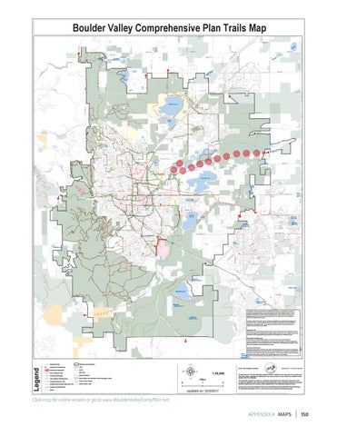
The Boulder Valley Comprehensive Plan (BVCP)Trails Map is a comprehensive guide for existing and proposed trails and trail connections for the entire Boulder Valley. It shows Autrey Reservoir proposed trails that have been planned through departmental master planning or area planning processes as well as trail connections that are important links in the Boulder Valley and regional trails systems.
Eggleston Reservoir No. 3
A color version of the trails map can be found at: http://www.bouldervalleycompplan.net and click on Plans. Refer to departmental master plans or area plans for more details on proposed or conceptual trails. The purpose and content of the map is described in the Implementation Section of the BVCP. Proposed Trails These trails are represented by dashed red lines on the Trails Map. These dashed lines show a general trail alignment accepted by the public entities involved. There may still be issues to be worked out at the project planning step, but the trail alignment is relatively certain. Conceptual Trail Alignments These trails are represented by circles on the Trails Map. These circles show the recommendations for the trail located as a conceptual trail corridor, as determined through planning processes. The specific alignment has not yet been selected, but the possible area of the trail is indicated by the location of the circles. Conceptual Connections Upper Conceptual connections between trails within the BVCP Planning Area to trails or destinationsChurch outside the planning area are shown with an arrow pointing from an existing or proposed trailLake toward an area outside the Planning Area Boundary. These arrows indicate a general direction
Legend
Great for potential connecting trails but not a specific alignment or trail corridor. Western Reservoir
Proposed Trail
Planning Area Boundary
Conceptual Connection
Lake
Conceptual Alignment
Creek
New Proposed Trail
City Park
Existing Underpass
School Property
Trail Outside Planning Area
Open Space and Mountain Parks Managed Lands
Existing Multi-Use Trail
County Open Space
Existing Soft Surface Multi-Use Trail
State Owned Land
Š 2017 City of Boulder, Colorado
1:25,000 0
Miles 1
Existing Pedestrial Trail Street
Updated on: 5/23/2017
2
SUBJECT TO REVISION
All rights reserved. The map information contained hereon is intended for the sole use of the purchaser and may not be copied, duplicated or redistributed in any way, in whole or in part, without the expressed written consent of the City of Boulder. The information depicted is provided as a graphical representation only. While source documents were developed in compliance with National Map Accuracy Standards, the City of Boulder provides no guarantee, express or Implied, as to the accuracy and/or completeness of the information contained hereon. Map produced by the City of Boulder Planning and Development Services Information Resources Group. For information call (303)441-3131 or visit us on the web at http://www.bouldercolorado.gov.
Click map for online version or go to www.BoulderValleyCompPlan.net.
APPENDIX A MAPS
150