
FACT SHEET NSW/QLD BORDER TO GOWRIE SECTION
FACT SHEET NSW/QLD BORDER TO GOWRIE SECTION
We acknowledge flooding and geomorphology are key areas of interest for communities along Inland Rail’s NSW/Qld Border to Gowrie section (the Project). We’ve undertaken extensive flood modelling in consultation with landowners and technical experts. We are committed to ensuring the design, construction, and operation of the project does not negatively impact flood behaviour or the surrounding environment.
The NSW/Qld Border to Gowrie section crosses several watercourses and floodplains.
We have completed detailed hydrological and geomorphological assessments which aligns with national guidelines and industry best practice.
Since 2016, we have used evidence from landowners, including photographs of historic flood events and recent flood event modelling data from councils and government agencies to inform our flood impact modelling. This supports our aim to minimise the impact that construction and operations may have on flood behaviour, affecting impacted landowners and nearby communities.
Our flood models have been peer reviewed and updated based on feedback. These models have also been confirmed as fit-for-purpose by the Independent International Panel of Experts for Flood Studies (the Expert Flood Panel), an independent panel established by the Australian Government and Queensland Government to review flood modelling and designs for Inland Rail in Queensland.
The Expert Flood Panel’s recommendations have been accepted and incorporated into the NSW/Qld Border to Gowrie revised draft Environmental Impact Statement (EIS) and will inform future stages of design and construction.
Flood Impact Objectives (FIOs) have been developed in consultation with the Panel to identify and guide the mitigation process for potential negative impacts associated with the project.
The FIOs aim to protect the environment and minimise impacts on properties and other existing infrastructure such as roads.
• Changes in peak water levels – varying targets have been set for a range of land uses and at flood sensitive receptors.
• Changes in time of inundation – understanding the impact of any changes to inundation timeframes on land and infrastructure.
• Changes of flood flow – minimising changes to flood-flow distribution across floodplain areas and understanding any changes that would increase the risk to flood sensitive receptors.
• Changes in flow velocity – maintaining existing velocities where practical and understanding any changes in the speed of water exiting culverts/bridges. Providing appropriate mitigation measures, considering soil conditions.
• Changes in flood hazard – limiting any changes in flood hazard (a metric which identifies higher risk and lower risk flood affected areas), considering flooding depth and the speed of water flow.
• Extreme event – considering impacts for extreme flood events.
• Sensitivity – understanding possible impacts on the NSW/Qld Border to Gowrie section in climate change and blockage scenarios.
We are developing effective mitigation measures to address potential flooding impacts identified in our models. The specific mitigation measures will be determined in consultation with affected landowners during the detailed design phase.
The Project is designed to minimise change to overland flow and surrounding hydrological profiles attributable to the Project, and reduce impacts to vegetation, watercourses and floodplains.
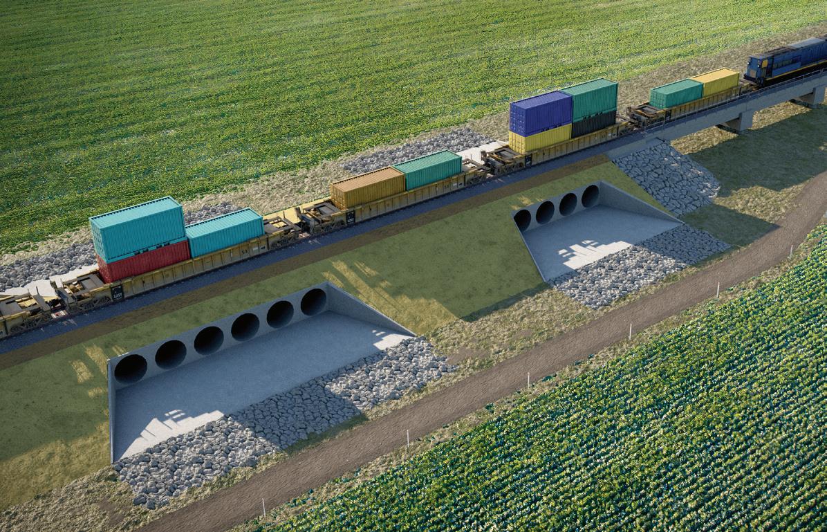
The current Project reference design includes over 3000 culverts and approximately 11km of viaducts and bridge structures to maintain existing water flow paths.
Through design and construction, there will be a focus on maintaining flow paths and minimising impacts to people, property, infrastructure and the environment.
We will consult with landowners and specialists to ensure we minimise changes to hydrological conditions because of the Project. We will be working closely with landowners to ensure property-specific detail is understood and considered to inform preferred design solutions.
We will implement a flood and geomorphic impacts mitigation framework and further design treatments to eliminate, reduce and address potential flood impacts. Further flooding mitigation measures will be included in future design and construction development to address remaining flooding and geomorphology impacts.
The specific mitigation measures will mostly be designbased solutions such as additional culverts, bridges and scour, aimed at further eliminating and reducing impacts.
To address concerns about the dispersive nature of soils in the project area, the cross-drainage design will minimise impacts on surrounding drainage and flow paths, preventing avoidable erosion, siltation, and watercourse instability.
Scour and erosion protection measures will be implemented around culvert headwalls, drainage discharge pathways, and bridge abutments.
We will continue working with landowners and councils to gather local flood event data and refine our modelling and detailed designs to ensure we deliver safe and resilient Inland Rail infrastructure.
Inland Rail is a 1,600km fast freight rail line between Brisbane and Melbourne that is connecting businesses, manufacturers and producers to national and global markets and generating opportunities for industries and regions during construction and beyond.
Delivering Inland Rail will help shift more goods onto rail and take tens of thousands of large trucks off our roads. This means faster, more reliable freight; safer, less congested roads; and fewer emissions.
74% of freight between Melbourne and Brisbane is moved by road
Moving freight by rail is four times more fuel-efficient than by road
One 1,800m Inland Rail train will take 110 B-double trucks off regional roads