the trail in four locations along the trail route. Through these groups, it is planned to have the entire province’s trail cut in 1996 and 1997. With the existing trails of Parc de la Gaspésie, Québec’s section of the trail will be complete in 1997. At the time of this writing, either completion or permission to establish the trail has been achieved for 250 of Quèbec’s 300 kilometers of trail. New Brunswick: Eight people have been hired under a government work project to scout and mark the 70 kilometers from Mount Carleton Provincial Park to the town of Kedgwick in the Restigouche region. Information on plants and animals is being gathered in order to locate the trail in interesting, nonthreatened areas. The section of the trail south of the park is scheduled to be finished in 1997. A 15-kilometer section of a former railroad bed has been purchased by the provincial government to be used for the trail. Similar to Québec’s Parc de la Gaspésie, part of the trail network in New Brunswick’s Mount Carleton Provincial Park will complement the IAT/SIA. Between Québec and New Brunswick, better than 122 kilometers of existing park hiking trails have been added as official components of the trail. Maine: The Maine chapter of the IAT/SIA has taken action to become a nonprofit corporation. The International Boundary Commission stated that the use of the international boundary from Mars Hill Mountain to Fort Fairfield, Maine, as part of the IAT/ SIA was permissible. This part of the trail was already cleared and has subsequently been marked with the trail blaze. Negotiations continue with major corporate landowners in the area between Katahdin and Mars Hill to assemble parcels of land for trail construction. Most recently, the Maine Chapter has constructed (October 1996) the first new trail shelter on the IAT/SIA Trail. It is of the traditional “Adirondack Shelter” design and is the first of 10 or so that will be constructed in Maine (there will be one every 10 miles). Working with the northern campus of the University of Maine at Presque Isle, and its Park and Natural Resource Man-
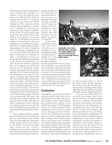
agement Program in the Department of Recreation and Leisure Services, an agreement has been reached through which faculty and students will be responsible for maintaining the trail between Mars Hill Mountain and the Border crossing at Fort Fairfield. The forest products industry is somewhat wary about what they see as a Canadian hikers on the trail near possibility of com- Mount Albert (above). Bunch berry promising their rights can be found in abundance with several other varieties of arctic over their land by ex- flowers on the trail (right). Photos by tending use to the Wilfred E. Richard. IAT/SIA. In particular, paper companies fear that National Park Service protection would follow, as was the case with the AT (Fletcher 1996) with purchase of the 2,200-mile (3,540 kilometers) AT corridor by the federal government. Government purchases included wide trail corridors and viewsheds in some areas. Pending federal acquisitions in western Maine have prevented ski trail not been accepted on the U.S. side of expansion at Saddleback Ski Resort out the border where IAT/SIA organizers of concern for the “viewscape.” had assumed (wrongly) that the international trail would begin within Baxter State Park. But, the IAT/SIA at this point Conclusions will begin outside of Baxter State Park. Although the concept for the IAT/SIA In essence, the IAT/SIA fares betdeveloped in the United States, it is in ter north of the border than it does Canada with crown lands and govern- south of the border. In both Canadian ment support where implementation provinces, a collective 138 kilometers has occurred more quickly. In the of trail are now hikable, with another United States, support of the large land- 30 kilometers in New Brunswick to be owners, the timber companies will be completed before the end of 1996. By absolutely critical to the success of the the end of 1997, all of Canada’s 540 project. Strong government involve- kilometers will be in service. In Maine, ment in the United States is not antici- of its 160-kilometer commitment, 30 pated. In Canada, both provinces have kilometers (about one-fifth) have been taken existing trails in both Québec implemented on the ground. Table 1 (Parc de la Gaspésie) and New Bruns- summarizes and offers an estimate of wick (Mount Carlton Provincial Park) trail status as of November 1996. I esand simply assigned them the addi- timate that at this time about 52% of tional function of being part of the IAT/ the trail either has been developed or SIA. And, additional lengths outside of the land for the trail has been committhe parks also have been purchased and ted. But this is rapid progress in a U.S. developed. This dual use strategy has public/private development. Bear in
THE IN TERNA TI ONAL J OU RNAL OF WILDERNESS Volume 3, Number 1
37