4 minute read
Satellite Image Processing Using Radiometric Resolution & Spectral Resolution


Sanjay Chilveri1 , Tanmay Jain2 , Prof. Harshada Mhaske3 Department of Computer Engineering, Pimpri Chinchwad College of Engineering, Pune
Abstract: This paper presents a detailed comparison of various image processing techniques for analysing satellite images. The satellite images are large in size, acquired from long distances and are affected by noise and other environmental conditions. Hence it is necessary to process them so that they can be used by the researchers for analysis.
Advertisement
Spectral resolution basically is to measure changes in things that impact our environments like water quality or vegetation etc. Satellite images are widely used in many real time applications such as in agriculture land detection, navigation and in geographical information systems. In this paper, a review of spectral resolution requirements for urban mapping evaluated how spectral resolution of high-spatial resolution optical remote sensing data influences detailed mapping of urban land cover. A comprehensive regional spectral library and low altitude data from the Airborne Visible/Infrared Imaging Spectrometer (AVIRIS) were used to characterize the spectral properties of urban land cover.
In this paper, a review of some popular machine learning based image processing techniques is presented. Also a detailed comparison of various techniques is performed. Limitations in each image processing method are also described. In addition to reviewing different methods, different metrics for performance evaluation in each of the image processing areas is studied.
Keywords: Satellite Image Processing, Image Processing, Radiometric Resolution, Spatial Resolution, Spectrum Resolution, Temporal Resolution, Machine Learning, Deep Learning, Classifier Spectral Resolution, Convolutional Neural Network(CNN).
I. INTRODUCTION
Satellite Image Processing is an important field in research and development and consists of the images of earth and satellites taken by the means of artificial satellites. But while taking images of Earth and various objects in space, the images are widely affected due to various environmental conditions and noise. Images are taken from a very long range, therefore also playing a major factor in not being able to acquire clear images.
We will be using various different algorithms in-order to perform image processing and identifying the images captured by the satellites.
In broader terms we can say that the Satellite Image Processing is a kind of remote sensing which works on pixel resolutions to collect coherent information about the earth surface. Due to Satellite Imaging, predicting weather conditions, or development of any natural calamity has become very easy.
Satellite Image Processing not only collects information about Earth but also collects images of deep space objects, making it possible for the humans’ to research and understand about deep space objects.
The goals of this paper is to understand various methods involved in Satellite Image Processing, to understand and perform Radiometric Resolution & Spectral Resolution on Satellite Images, to learn about how images acquired from satellites are cleaned and used for various analysis, & to be able to Develop Understanding of Earth’s Surface and its terrain.
II. LITERATURE SURVEY
1) In this paper talks about introducing a new method called Mixed Radiometric Normalization (MRN) method, which is being used to eliminate Radiometric Differences in Image Mosaicking. The authors have proposed an approach that combines both absolute and relative radiometric normalization methods. To perform this experiment, ZY-3, GF-1, and GF-2 data have been used, and has been observed that the proposed model satisfactorily eliminates Radiometric Differences in Image Mosaicking.
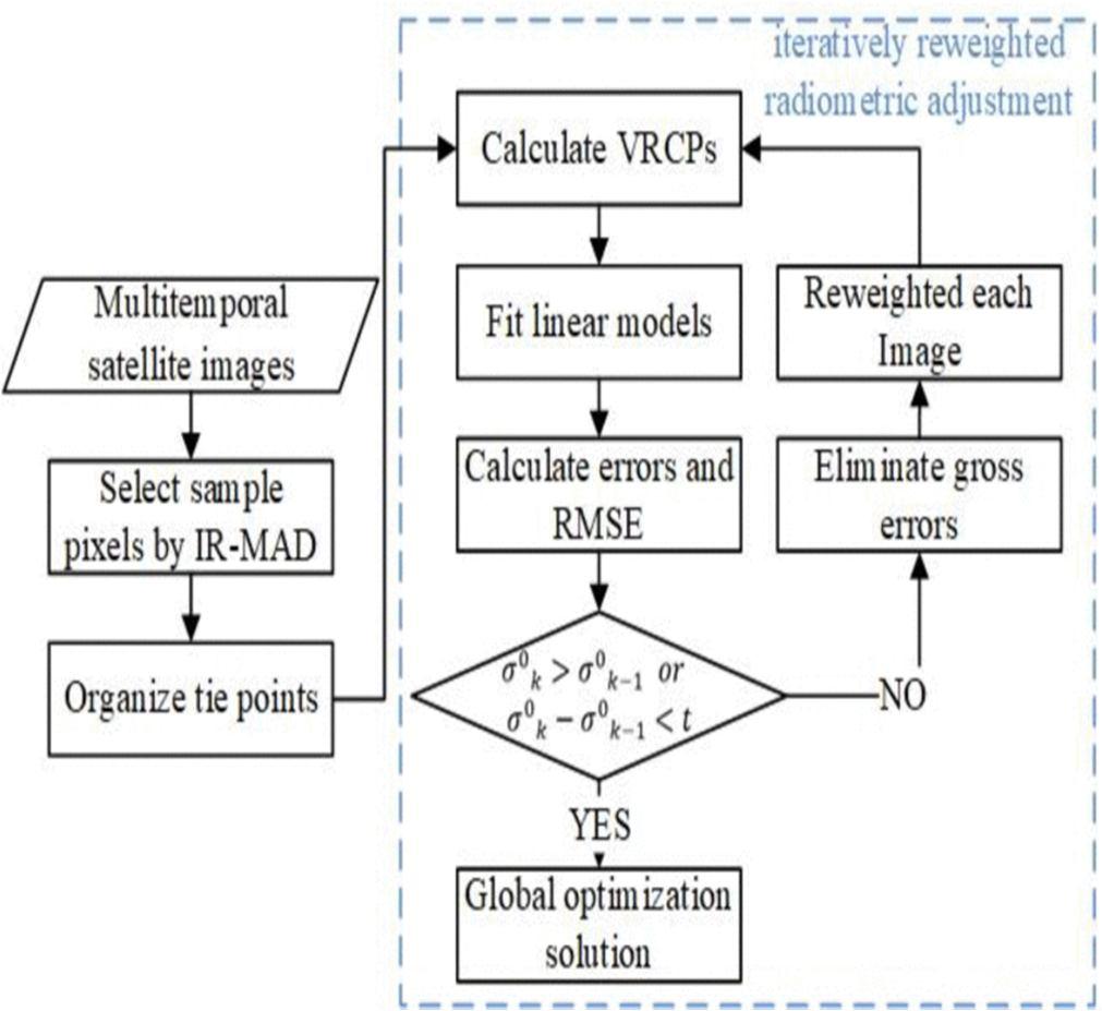
2) The 2nd paper, propsed by Kunbo Liu, Tao ke, Pengjie Tao, et. al., is based on a Comp. Radiometric Normalization Method for multi-temporal High Resolution Satellite Images (HRSI) using Radiometric Block Adjustment. Here, the authors have considered 4 groups of different HRSI Dataset to validate the performance of the method proposed.
ISSN: 2321-9653; IC Value: 45.98; SJ Impact Factor: 7.538

Volume 11 Issue III Mar 2023- Available at www.ijraset.com
The authors of this paper proposed 2 steps from the methodology:
First, Selecting Radiometric Tie Points (RTPs) using IR-MAD.
Second, Conducting IRRA on the selected RTPs for Radiometric Normalization.
3) The paper proposes a Hybrid Canonical Correlational Analysis with hybrid regression model, that will help tackle problems of high computation and storage cost that were caused due to highly sized Kernel Matrices and Non-Linear Regression. Landsat-7 and Landsat-8 Satellite images were used as to check the working of the proposed model
4) METRIC processing algorithm has been proposed by the authors of this paper on “Sensitivity of evapotranspiration retrievals from the METRIC processing algorithm to improved radiometric resolution of Landsat 8 thermal data and to calibration bias in Landsat 7 and 8 surface temperature” in order to improve the Radiometric Resolution achieved by thermal images from Landsat–8. METRIC stands from Mapping Evapotranspiration at high Resolution using Internalized Calibration. The result of this paper depicts that there was no change in accuracy of METRIC and LST models.
5) The 5th research paper that we reviewed, talks about re-introducing existing methods and models like Pseudo-Invariant Features (PIF’s), Simple Regressions (SR), No Change Scattergrams (NC), and Histogram Matching (HM); and these models and methods have been applied to IKONOS & Quick Bird multi-spectral Images and perform normalization on their Radiometric Difference. To overcome problems of Band Difference, and to achieve more accurate results, some improvements have been introduced in the existing models. The results of the paper have been used to perform visual and Statistical Analysis.
6) An effective and automatic method based on Gaussian Mixture Model (GMM) has been proposed here. The proposed method talks about using two main steps; firstly, acquiring invariant pixels from analysing different images by GMM. And Secondly, using the obtained pixels to model relationship between multi-temporal images. To evaluate the proposed methodology, Quickbird, IKONOS, Super-View-1, & Worldview datasets were thoroughly analysed. The results show that the propose model has considerably improved the radiometric variation of the images obtained from the obtained datasets.
The authors of the paper have proposed a Relative Radiometric Normalization (RRN) method to perform radiometric normalization on multi-temporal images. The authors have performed this experiment in order to remove the outliers as well as find better linear transformation between reference images. Fig:2 & Fig:3 show the architecture of the proposed methodologies.
As Proposed by the authors, there are two main steps following these architectural methods:


