V.34 FEBRUARY 2024 VOLUME THIRTY-FOUR 2024 Winter Issue H ydro V isions o fficial P ublication of t H e G roundwater r esources a ssociation

HISSN 2837-5696
HYDROVISIONS is the official publication of the Groundwater Resources Association of California (GRA). GRA’s mailing address is 808 R Street. Suite 209, Sacramento, CA 95811. Any questions or comments concerning this publication should be directed to the newsletter editor at hydrovisions@grac.org
The Groundwater Resources Association of California is dedicated to resource management that protects and improves groundwater supply and quality through education and technical leadership.
EDITOR
Rodney Fricke hydrovisions@grac.org
EDITORIAL LAYOUT
Smith Moore & Associates
EXECUTIVE OFFICERS
PRESIDENT
Christy Kennedy
Woodard & Curran
Tel: 925-627-4122
VICE PRESIDENT
Erik Cadaret
West Yost
Tel: 530-756-5905
SECRETARY
Moises Santillan
Water Replenishment District
Tel: 562-275-4279
TREASURER
Rodney Fricke
GEI Consultants
Tel: 916-631-4500
DIVERSITY, EQUITY AND INCLUSION OFFICER
Marina Deligiannis Stantec
Tel: 916-418-8242
ADMINISTRATIVE DIRECTOR
Amanda Rae Hall
Groundwater Resources Association of California ahall@grac.org
DIRECTORS
Jena Acos
Brownstein Hyatt Farber Schrek
Tel: 805-882-1427
Trelawney Bullis
AC Foods, Central Valley
Tel: 530-205-8387
Dave Ceppos
Sacramento State
Tel: 916-539-0350
Elis Haddad
Haley & Aldrich
Tel: 408-529-9048
Dr. Hiroko Hort
GSI Environmental, Inc
Annalisa Kihara
State Water Resources Control Board
Tel: 916-947-7938
Yue Rong
Los Angeles Regional Water Quality Control
Tel: 213-576-6710
Abhishek Singh INTERA
Tel: 217-721-0301
Clayton Sorensen
West Yost Associates
Tel: 925-949-5817
Savannah Tjaden
Water Savvy California
Roohi Toosi
APEX Environmental & Water Resources
Tel: 949-491-3049
John Xiong
Haley & Aldrich, Inc.
Tel: 714-371-1800
To contact any GRA Officer or Director by email, go to www.grac.org/board-of-directors
The statements and opinions expressed in GRA’s HydroVisions and other publications are those of the authors and/or contributors, and are not necessarily those of the GRA, its Board of Directors, or its members. Further, GRA makes no claims, promises, or guarantees about the absolute accuracy, completeness, or adequacy of the contents of this publication and expressly disclaims liability for errors and omissions in the contents. No warranty of any kind, implied or expressed, or statutory, is given with respect to the contents of this publication or its references to other resources. Reference in this publication to any specific commercial products, processes, or services, or the use of any trade, firm, or corporation name is for the information and convenience of the public, and does not constitute endorsement, recommendation, or favoring by the GRA, its Board of Directors, or its members.


Welcome to 2024 –A New Chapter for GRA!
Dear GRA Members and Water Industry Colleagues,
As we embark on a promising journey into 2024, it is my great honor and privilege to serve you as the President of the Groundwater Resources Association (GRA). Having been an integral part of this organization for the past six years; serving in various capacities such as a Conference Chair, Chair of the EEA Committee, Secretary, Vice President, and Chair of the Finance Committee, I am thrilled to lead GRA in the year ahead.

Reflecting on my journey with GRA, I recently delved into the HydroVisions archives and stumbled upon my own name from Spring 2001 when I joined this incredible association. Little did I know, seated around those round tables at a restaurant in downtown Oakland, that I would one day have the privilege of guiding GRA as its President.


As we step into 2024, we find ourselves amidst positive developments with a strong western focus of groundwater replenishment programs and policies, echoing the positive replenishment of our local reservoirs and aquifers #mothernatureisaboss! This year promises to be an exciting one, not just for replenishment, but brimming with opportunities for knowledge-sharing and collaboration within our groundwater community… we see you PFAS and Chromium-6!
As we continue our journey, GRA remains the premier association for education, knowledge transfer, advocacy, and networking within the water industry. The success we've achieved in making groundwater visible has positioned GRA as a leader in facilitating dialogue, fostering collaboration, and advancing best practices.
Thanks for being part of GRA – you're the backbone of our success. Cheers!
 Christy Kennedy President, Groundwater Resources Association


During the June 2023 GRA/ACWA SGMA Implementation Summit, a roundtable session facilitated group discussions around key challenges GSA managers grapple with in the current phase of SGMA implementation. This article briefly summarizes discussion points and offers tips and resources for further review.
Topic 1: Drought Planning
This topic focused on Drought planning, management, and mitigation, and how it relates to SGMA planning.
A key discussion point identified synergies and opportunities among local existing planning programs (SB 552, Urban Water Management Plans, Water Storage Contingency Plan, Integrated Regional Water Management, etc.) and Groundwater Sustainability Plans (GSPs) including:
• Concerns related to water quality impacts during recharge activities. Management strategies could include opportunities to tie irrigated lands regulatory program (ILRP) reporting with recharge on agricultural lands. It is important not to address water quantity issues through strategies that may impair water quality.
• Self-Help Enterprises is a good resource for designing and considering criteria for a domestic well mitigation program, but tough questions remain including: who funds the program? Which wells are eligible? What is the total funding needed?
• Some GSAs have incorporated domestic well mitigation funding/revenue in their proposition 218 property assessment process.
• There is difference in opinion about whether GSAs should be involved in drought response, but there is consensus that GSAs and Counties should be in close coordination.
This topic focused on Demand management/reductiongetting stakeholders and boards to agree on these topics.
The discussion revolved around 4 key points:
1. How to gain momentum in demand management? A challenge to moving forward in demand management is lack of funding. Without funding, it is difficult to repurpose programs and incentives; some GSAs can only do small “handshake” deals (e.g., a grower promises they will decrease use five percent this year). In some places (Merced County) –there are more applications for funding than funds available for repurposing. One solution could be to look to untapped financial sources in private money for carbon capture and regenerative agriculture. The problem is not just financial though – there are some fear-based responses, where people fear changing how they have historically operated. In some cases, it has been difficult for GSAs to act as regulators and enforcers, despite the legal authorities they hold. In other cases, GSAs are having a hard time coordinating with land use agencies (e.g. counties) – which tend to approve development without consulting the GSAs about (ground)water availability. Counties also tend to be risk adverse, and boards do not want to stick their necks out politically on demand management. Finally, agricultural land retirement has been a focus of demand management, but some basins are primarily urban and their demand has hardened over the years. How will these basins reduce demands in the future if additional cuts are needed?

2. Demand management implementation timeframe: the tradeoff between kicking the can down the road (e.g. implementing measures right before 2040), vs. doing a little bit every five years with interim milestones (DWR has reinforced this messaging).
Some GSAs, which thought they were in really good shape in 2018/19, originally thought of allocations as a “down the road” strategy. But by doing allocations sooner, they realized they would get a longer and smoother ramp down. They found that having allocations in place helped them promote and implement recharge and provide recharge credits.
3. Land repurposing is difficult, not an “end all, be all”. There were many optimistic conversations around land repurposing, but not many tough questions are being answered. For example, how much water will repurposed land still require? Will growers plant cover crops? Will they have a checkerboard of fallowed lands adjacent to those still in production? Repurposed land requires ongoing management – it is not just convert it and stop managing.
4. Allocations vs. adjudications: the good, the bad and the ugly. When demand management goes really far, people start thinking adjudication is the solution. Is it necessarily a bad thing? Maybe not. Most think it is long and slow – but Borrego Springs recently did it quickly. There are additional benefits to being under court jurisdiction and doing mediation, for example access to some financial routes not subject to Proposition 218.
This topic focused on Inter-connected surface water and depletions, technical and policy considerations.
The discussion revolved around two key points:
• Gains and losses are induced by many variables – not just pumping (surface water diversions, temperature, dam operations, upstream out-of-basin activities, etc.). Parsing out the pumping contribution to depletions is a challenge.
• We need more data! There are often insufficient stream gauges, and many gauges are located outside of basin boundaries. GSAs recognize installation of shallow/riparian monitoring wells would be helpful;
however, hindrances include (1) they require years of successful monitoring to have sufficient data, (2) GSA funding priorities (and availability), (3) the State has not prioritized stream monitoring infrastructure (recommendation to revisit SB19).
This topic focused on Funding opportunities for capital projects and in-kind services for SGMA project implementation.
The discussion revolved around 5 key points:
• Pursue grants first, if applicable. GSAs that are water purveyors/irrigation districts can charge rates/fees but can also use grants to cover capital costs. However, rates/fees provide flexibility to repay loans or pay O&M costs when grant funding is not available.
• Meet with funding agencies when possible. Meetings can help make funding agencies aware of projects and needs and are opportunities for early feedback and to gain a better understanding of which funding opportunities are appropriate. Meeting after an unsuccessful grant application may also help gain insight on how to improve applications for future funding opportunities.
• Partner with other agencies/local partners where possible. Partnering can leverage existing resources/ infrastructure, open new funding opportunities, share cost burdens, and increase collaboration.
• Which funding to pursue depends on many factors. Appropriate funding sources vary depending on the effort being funded: GSA operating costs, feasibility studies, Projects, Management Actions, or something else. Preferences of local interested parties and/or the GSA Board of Directors shape the funding sources pursued and relied upon and how local fees are distributed.
• Relay funding challenges to DWR. Let DWR know what challenges were encountered in funding within article continues on next page
annual reports and periodic evaluations. It would be helpful to know what SGMA implementation costs in other basins.
Topic 5: Well Permitting
This topic focused on Well permitting – approaches to meeting Executive Order requirements.
The discussion revolved around two key points:
• There is a missing component of the Executive Order: Are GSAs reviewing well applications to ensure water quality is protected from continuous screening of multiple aquifers that can induce inter-aquifer mixing?
• Will public trust impacts based on streamflow depletion related to the well permitting be considered in the permanent well permitting solution?
Topic 6: Well Registrations
This topic focused on Basin-wide well registrations and data –success stories.
The discussion revolved around the key points below:
• Sonoma County well registration program has been adopted: Groundwater Users Information Data Exchange (GUIDE)
- Available to view online at: https://sonomavalleygroundwater.org/guide/
• Sonoma GSAs conducted a fee study – fees were adopted in 2022 and are actively being collected. Fees are based on the best available information (e.g., assessor parcel information, crop mapping, etc) to estimate how much groundwater is being used on each parcel. Fees include 0.5 acre-feet per rural residential parcel, if there is more than one dwelling unit on parcel, then the fee increases. This process has included close coordination with the County, which has a contract with the GSAs to process the data for the GUIDE program.
• Some areas of improvement include:
- Enforcement of program
- Trade-offs with self-regulated programs
- Tools, Resources, and Data Sets
■ Potential DWR support/creation of library (e.g., tools, resources, guideline or package)
■ How to translate throughout the whole process (e.g., DMS, coordination, integration with other databases)
- Accuracy of matching up individual parcels with wells
This topic focused on Use of data and tools for management decisions and policy considerations.
The discussion revolved around two key points:
• Even though there are many useful existing DWR tools that are widely used, people do want custom localized features and data products.
• There is an interest in “one-stop-shop” for all SGMA/
groundwater/surface water related information and data for landowners to access on a custom scale featuring a dashboard interface that includes visualization features, mapping and the ability to download all data.
This topic focused on Water markets and allocations: is it right for you?
The discussion revolved around four key points:
• Roughly half of all critically overdrafted basins (COD) included groundwater allocations and water marketing as a strategy for achieving sustainability.
• Having stakeholder buy-in and education is essential for designing the rules of a market and for adoption. Stakeholders need to understand how market rules impact their operations.
• Education is time- and people-intensive but critical to market success. Designing a market is typically a yearslong (4-6 years) process. Buckle up!
• Technology is a must. A market needs a central, neutral tool to support monitoring and enforcement.
Topic 9: Streamlined Permitting
This topic focused on Streamlined and integrated permitting approaches across multiple regulatory entities (specifically related to recharge projects).
The discussion revolved around five key points:
• It is critical to start working on your permit early in the process.
• In capturing flood flows, diverters need to be nimble and have done the work ahead of time.
• The definition of “flood” varies widely by location.
• How does a basin account for water that is diverted from flood flows without a water right?
• It is important to educate all water users on how to take advantage of flood flow diversion permits. Landowners want to be helpful.
This topic focused on Outreach, engagement, and inclusion of Communities of Interest.
The discussion revolved around the following key points:
• It is important to meet people where they are and bring engagement to where people are already gathering.
• Working with community-based organizations and other representative organizations who can help add capacity for communities who have limited time and resources to engage. Can you provide resources to help people engage?
• Be iterative - keep an open mind about your process and keep asking who you might be missing.
• Do not expect to be trusted - build trust through respect and follow through and repeated engagement.
Knock on doors and have one-on-one conversations.
• Respect cultural norms and seek to understand the communities you are engaging with.
• Seek assistance from DWR for Facilitation Services!
• Problem solve around hybrid meeting access - what resources can be leveraged while being mindful of Brown Act compliance.
• Providing opportunities for education around complex topics is key – it may take a lot of time to get everyone on the same page.
• Finding common interests and things people value differently that they can trade may be important to building agreements.
• Provide ways for people to continue the dialog.
This topic focused on Subsidence - Policy and Management Considerations.
The discussion revolved around the following key points:
• Subsidence has been mitigated in the Santa Clara and LA basins by creating new supply and limiting demand so that groundwater levels do not go lower than historical levels, particularly in deeper aquifers below clay layers. Similar approaches could be used to reduce damage to or flow in surface water canals, especially because reliable surface water is needed to reduce groundwater pumping and avoid more subsidence. This could include buffer zones where deeper pumping is prohibited and surface water supply is provided in lieu of groundwater.
• Management of subsidence is still constrained by lack of data and tools. Additional extensometers in key areas would provide information on the aquifer layers subject to subsidence, however costs may be prohibitive. Groundwater model codes that accurately simulate time-delayed subsidence are needed to establish sustainable management criteria that are truly coupled with groundwater levels, especially in areas that have criteria allowing future lowering of groundwater levels.
This topic focused on Water quality and how it currently affects SGMA legislation and moving forward.
The discussion revolved around the following key points:
• Water quality data from GAMA, ILRP, and CV-SALTS can supplement SGMA data.
• Matching wells in GAMA can be difficult and managing water quality data is challenging, especially across so many different data sources.
• What water quality constituents matter?
• Who is ultimately responsible for addressing water quality – especially for ensuring disadvantaged communities have safe drinking water?
• Monitoring and data collection are getting more coordinated.
• Needs assessments with communities – how to identify multiple benefit opportunities.
• How to communicate GSA responsibility in the water quality realm to the public
• SGMA purview should not make water quality worse. If water quality is getting worse, there is a need to prove it is not because of groundwater management practices.
• There are opportunities to collaborate with universities and research entities to understand contaminant migration and understand future potential water quality issues.
• There are data and privacy concerns – fear, access –building relationships is key to build trust.
• Unclear in the regulations how to address water quality, specifically which constituents? What is the responsibility of the GSA? Confusion as to how to operate in the water quality space.
• Most GSPs failed to adequately consider groundwater quality – GSAs consistently identified only one or two contaminants (often nitrate).
• Collaboration with other programs is key – CV SALTS, ILRP
• Too many agencies are regulating water quality which makes communication and collaboration difficult.
• Sustainability indicator interactions – impacts of declining water levels on groundwater quality. Cumulative public impacts need to be understood and well communicated.
• Critical to have clarity on roles and responsibilities of GSAs with respect to water quality - especially legacy issues not directly related to current groundwater management.
• One water – how can solving water quality problems benefit other aspects of groundwater management and vice versa.
Based on these discussions, it is clear that SGMA implementation actions have helped to start breaking barriers between agencies that are involved in activities related to water management, such as land use planning, water quality monitoring, and reservoir operations (for flood control and potential recharge). As such, SGMA is an opportunity for innovation and creativity!
BIO: Lisa Porta, PE, is a Principal Water Resources Engineer and California Water Strategy Lead with Montgomery & Associates, in Sacramento, CA. She has more than 15 years of groundwater modeling and integrated water resources planning experience in California and the Western United States. She specializes in SGMA implementation and supports local water agencies with navigating the increasingly complex regulatory environment with using appropriate data and tools.

Introduction
Monitoring land subsidence is essential for understanding impacts from groundwater use and informing groundwater management. This paper is the second installment of a fivepart series on land subsidence (the lowering of land surface elevation) and provides an overview of methods to measure and monitor land subsidence. An overview of the physical mechanisms leading to subsidence due to groundwater pumping and sediment compaction can be found in “California’s Sinking Feeling: An Introduction to Subsidence” (published Summer 2023). Subsequent articles in this series will discuss the following topics:
• Spring 2024 – Tools and Models: Estimating and Predicting Subsidence
• Summer 2024 – Pitfalls of Subsidence: Damages Done
• Fall 2024 – Arrested Displacement: Subsidence Mitigation
Land subsidence monitoring can be separated into two general categories: measurement of changes in land surface elevation and measurement of compaction within the subsurface. The measurement techniques discussed here include Leveling, Continuous Global Positioning System (CGPS), Interferometric Synthetic Aperture Radar (InSAR), and Extensometers. Leveling and CGPS focus on measuring elevation of the land surface; InSAR measures relative changes in elevation between repeat observations; and extensometers measure compaction.
The oldest and simplest technique for monitoring land subsidence is leveling. Leveling involves surveying benchmarks with a precision instrument designed to measure relative change in elevation between a location of known elevation and other locations some distance away. In 1935, a type of leveling called spirit leveling detected the first known land subsidence in the Central Valley of California (Figure 1). Leveling can provide accuracies better than 0.05 feet and routinely as high as 0.01 feet. However, leveling surveys require campaign-style surveying (labor intensive) and are often limited in their spatial extent. Data from leveling surveys are archived by the National Geodetic Survey (NGS), USGS, Bureau of Reclamation, California Department of Water


Resources (DWR), California Department of Transportation (Caltrans), and other local agencies. However, the NGS hosts the most comprehensive leveling dataset for measuring land subsidence due to periodic updates to the control survey benchmarks.
Continuous GPS
Global Positioning Systems use a technique called trilateration to obtain the precise three-dimensional position of a receiver on the ground. CGPS stations typically collect position information every 15 seconds, and these data are processed to produce a daily 3D position of the sensor. Changes in vertical position with time allow tracking of subsidence or uplift.
CGPS measurements can provide accuracies within about 0.02 feet for vertical positioning, in spite of the ‘noisy’ character of the data, which is addressed by averaging (Figure 2). While the first Navstar GPS satellites were launched in the late 1970s, data availability was limited. Since about the mid-2000s, a network of CGPS stations maintained by UNAVCO and the Scripps Orbit and Permanent Array Center (SOPAC) have provided publicly available data for numerous sites across the Western United States.
InSAR
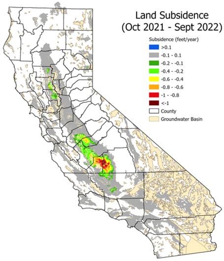
Synthetic Aperture Radar is an active remote sensing data collection technique where a sensor illuminates the Earth’s surface and then records the amount of energy reflected back Displacement estimates are produced using phase information from SAR data collected at two different times over the same location. The difference in phase between SAR images is called an Interferogram, which represents the ground displacement between the two times. While InSAR technology has been available since the mid-1970s, its use for earth observation applications truly began in the early 1990s with the launch of the European Space Agency (ESA) ERS-1 SAR satellite mission. The use of SAR imagery rapidly accelerated with the launch of the ESA Sentinel-1A mission in 2014 due to its open data policies and high spatial and temporal resolutions. Recognizing the utility of InSAR displacement maps for monitoring groundwater basins, the California DWR provides processed subsidence datasets with a reported accuracy of

18 mm, starting with January 2015 through October 2023
(Figure 3). Raw and derived InSAR data for earlier time periods and locations are freely accessible through the Alaska Satellite Facility and NASA Jet Propulsion Laboratory (JPL) but require knowledge of interferometric processing for subsidence monitoring or are only available by request.
Extensometers
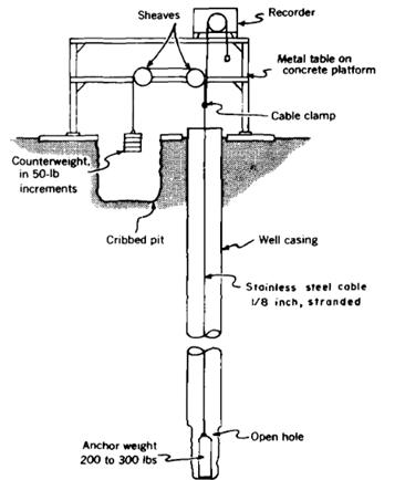
Extensometers measure compaction and expansion of the aquifer system at depth-discrete intervals within the subsurface. Several types of extensometers are available, including cable, pipe borehole, and magnetic extensometers. Cable extensometers have an anchor weight at the bottom of a borehole attached to a steel cable under tension (Figure 4). A recorder measures the amount of cable length that appears above the casing as the surface elevation changes. Similarly, pipe borehole extensometers use a steel pipe coupled to rock at depth in a borehole, but with a device called a linear potentiometer that is attached to the pipe and ground surface to measure displacement. Of recent interest are magnetic extensometers that use magnetic rings anchored to specific sediment types along a borehole. As a probe travels through
article continues on next page
the borehole, the electrical current and depth are recorded and can be used to measure deformation between magnetic rings. For all extensometers, the integrated compaction over the instrumented interval(s) provides a component of total land subsidence. Extensometer accuracy can be within a few hundredths of a foot. The USGS installed more than two dozen extensometers in the San Joaquin Valley starting in the 1950s to measure land subsidence. All of these extensometers are either cable or pipe borehole extensometers. The California DWR has a network of extensometers in the Sacramento Valley.
Conclusions
Each of the land subsidence monitoring methods described here have their strengths and limitations. Leveling is simple and very accurate but is labor-intensive and can be limited in the number of repeat observations by the size of the area of interest. Similarly, CGPS stations are limited to relatively few locations, but have an advantage of high frequency measurements to understand land surface dynamics. One challenge with CGPS is the data can be noisy even in areas with little subsidence. InSAR is the lowest accuracy data stream for measuring land subsidence. However, InSAR can be used to measure very large areas of interest and can provide
valuable information to better define rates and extents of land subsidence. Extensometers provide important insight on specific depths in the subsurface where compaction is occurring and at high accuracy. However, extensometers are expensive to install and maintain relative to the other techniques. Extensometers may not be able to identify total compaction if compaction occurs in parts of the subsurface not explicitly monitored. However, when paired with another measurement such as InSAR, total subsidence and compaction within the subsurface can be particularly informative to groundwater modeling.
The challenges posed by subsidence are complex and evolving, demanding continued innovation in monitoring techniques and a commitment to sustainable practices. Through ongoing research and comprehensive monitoring, we can better mitigate the effects of subsidence and preserve the health of our groundwater systems


In this tenth HydroVisions article on per- and polyfluoroalkyl substances (PFAS), we discuss the nature of vadose zone PFAS source areas and how those source areas create and sustain groundwater plumes. The resulting plumes may exceed drinking water and/or cleanup criteria potentially for many centuries, thus an understanding of source area and plume dynamics is essential for effective groundwater resource management and PFAS remedial strategies.
PFAS source areas are commonly created through surface or near-surface releases of PFAS-bearing products and wastes. The PFAS, therefore, generally must migrate through the vadose zone prior to reaching groundwater1,2. For this article, we will focus on historic aqueous film forming foams (AFFF) used for firefighting, and associated fire training and testing areas, because such areas are often implicated as the source for large PFAS groundwater plumes and are perhaps the most well studied. The concepts outlined, however, are broadly applicable to most other PFAS source areas.
AFFF are a complex mixture of water, surfactants, solvents, and other additives and modifiers, of which fluorinated surfactants and their salts containing PFAS comprised about 1.5-6.5% by mass of the AFFF concentrate1,2 (Figure 1). Upon use, the concentrate was diluted with water (1 part concentrate to 33 parts water) and aerated to create firefighting foam. Thus, PFAS comprised only a fraction of a percent of the applied foam. The specific PFAS present in AFFF was generally held as a closely guarded trade secret by AFFF manufacturers. Detailed analyses of AFFF formulations to unravel the specific PFAS present find that the common PFAS (such as perfluoro octane sulfonic acid [PFOS], perfluorooctanoic acid [PFOA], and the like)

typically measured by commercial analytical laboratory methods comprise up to 60% of the total PFAS concentration in AFFF1,2. The PFAS in the remainder are generally polyfluorinated compounds (compared to perfluorinated compounds), which have one or more hydrogenated carbons (C-H bonds), an ether linkage in the carbon backbone, and/ or a larger functional (or “head”) group. These attributes make most polyfluoroalkyl compounds more susceptible to degradation in the environment2
Although PFAS compounds are commonly referred to as “forever chemicals,” many of the polyfluorinated compounds found in AFFF will slowly degrade in the environment. Those compounds are often referred to as “precursors” and they will transform to terminal perfluoroalkyl acids (PFAAs) typically measured in groundwater. An example3

of precursor transformation in the environment is provided in Figure 2. In this example, perfluorohexane sulfonamido propyl tertiary amine (PFHxSAmS), a precursor found in 3M AFFF formulations, degrades through a three-step process to perfluorohexanoic acid (PFHxS), a terminal PFAS compound that is commonly detected in groundwater and is included in the proposed Federal MCLs. Terminal PFAS are not known to readily degrade under typical environmental conditions.
In general, larger PFAS molecules (e.g., PFOS and PFOA) tend to adsorb more strongly to solid surfaces than their smaller counterparts (e.g., perfluorobutanoic acid [PFBA] and perfluorobutane sulfonic acid [PFBS])4. Precursor PFAS tend to have large head groups and, for the reason above, remain adsorbed on soil surfaces for long periods. Such precursors have low mobility and thus a low risk of contaminating underlying aquifers directly but can transform into more mobile PFAAs (e.g. PFOS, PFOA, PFBS, PFBA) which can be more readily transported into the groundwater system3. These PFAAs are referred to as terminal PFAS and do not readily degrade in the environment. Precursor PFAS can be conceptualized as relatively immobile shallow source zone reservoirs that generate mobile PFAAs that can contaminate deeper groundwater3.
Modeling studies suggest that precursor PFAS source zone reservoirs contain enough mass of precursors to sustain terminal PFAA risks to groundwater for over 100 years3. Thus, analyzing source zones for oxidizable precursors is of critical importance to assessing long-term leaching of PFAA. Total precursor mass in a source zone can be quantified with the total oxidizable precursor (TOP) assay and the extractable organic fluorine (EOF) assay3. Because AFFF source zones are generally located in the vadose zone, determination of groundwater recharge is critical for assessing the leachability of terminal PFAAs3,4. Modelling and experimental evidence have shown that most PFAS leaching occurs during periods of temporary water saturation in the vadose zone. This leaching occurs during springtime rainy seasons, or during large storm events when sufficient water is available to move through the macropore structure of the vadose zone5. Over time, the combination of source zone flushing and precursor transformations will drive the depletion of the source zone.

Ruyle et al.,
article continues on next page
Once the terminal PFAAs reach the groundwater table, their transport within the saturated media is governed by wellknown hydrogeologic processes of advection, dispersion, and sorption. Adsorption and subsequent retardation within the aquifer matrix depends on the chemical characteristics of individual PFAS, porewater chemistry (pH, ionic strength of the groundwater), nature and type of soil/aquifer matrix (e.g., fraction of organic carbon and positively charged mineral surfaces), and the presence of any co-contaminants that may alter the sorption characteristics at the soil-water interface.1,2,4 Moreover, given the surfactant nature, PFAS accumulate at soil, water, and air interfaces, which can lead to higher concentrations of PFAS at or near the water table interface.4 Due to the long-term retention of terminal PFAAs in the vadose zone (which act as continual sources into the groundwater), their recalcitrant (little to no natural degradation) nature, and high solubility in groundwater, PFAS plumes in the groundwater can be persistent, fast-moving, and extensive. As such, source zone (vadose zone) capping and/or excavation and various enhanced attenuation techniques (via injection of particulate carbon amendments), are considered to be viable strategies to halt migration and limit the spread of PFAS plumes in groundwater aquifers6.
Other common source areas for PFAS include industrial point sources7, landfills, and wastewater treatment plants8. The composition of PFAS sources varies widely from industry to industry, as does the concentration of PFAS used for industrial application7. Industrial discharges are typically on the land surface, meaning vadose zone transport should be considered. Landfill leachate is characterized by its high concentration of precursors known as fluorotelomer carboxylates8, which can readily transform into PFAA. While landfills are typically designed to be above the saturated zone, groundwater table fluctuation poses a risk for high PFAS discharge events. Wastewater treatment plants are considered to be a surface water exposure pathway but can pose a risk to groundwater where there is surface water - groundwater interaction.
Reference
(1) Moody, C. A.; Field, J. A. Perfluorinated Surfactants and the Environmental Implications of Their Use in Fire-Fighting Foams. Environmental Science and Technology 2000, 34 (18), 3864–3870. https://doi.org/10.1021/es991359u
(2) Houtz, E. F.; Higgins, C. P.; Field, J. A.; Sedlak, D. L. Persistence of Perfluoroalkyl Acid Precursors in AFFF-Impacted Groundwater and Soil. Environmental Science and Technology 2013, 47 (15), 8187–8195.
https://doi.org/10.1021/es4018877.
(3) Ruyle, B. J.; Thackray, C. P.; Butt, C. M.; LeBlanc, D. R.; Tokranov, A. K.; Vecitis, C. D.; Sunderland, E. M. Centurial Persistence of Forever Chemicals at Military Fire Training Sites. Environ. Sci. Technol. 2023, 57 (21), 8096–8106. https://doi.org/10.1021/acs.est.3c00675
(4) Brusseau, M. L. Influence of Chain Length on FieldMeasured Distributions of PFAS in Soil and Soil Porewater. Journal of Hazardous Materials Letters 2023, 4, 100080.
https://doi.org/10.1016/j.hazl.2023.100080.
(5) Wallis, I.; Hutson, J.; Davis, G.; Kookana, R.; Rayner, J.; Prommer, H. Model-Based Identification of Vadose Zone Controls on PFAS Mobility under Semi-Arid Climate Conditions. Water Research 2022, 225, 119096. https://doi.org/10.1016/j.watres.2022.119096
(6) Newell, C. J., Javed, H., Li, Y., Johnson, N. W., Richardson, S. D., Connor, J. A., & Adamson, D. T. 2022. Enhanced attenuation (EA) to manage PFAS plumes in groundwater. Remediation, 32, 239–257. https://doi.org/10.1002/rem.21731.
(7) Glüge, J.; Scheringer, M.; Cousins, I. T.; DeWitt, J. C.; Goldenman, G.; Herzke, D.; Lohmann, R.; Ng, C. A.; Trier, X.; Wang, Z. An Overview of the Uses of Per- and Polyfluoroalkyl Substances (PFAS). Environ. Sci.: Processes Impacts 2020, 22 (12), 2345–2373. https://doi.org/10.1039/D0EM00291G
(8) Joseph, N. T.; Schwichtenberg, T.; Cao, D.; Jones, G. D.; Rodowa, A. E.; Barlaz, M. A.; Charbonnet, J. A.; Higgins, C. P.; Field, J. A.; Helbling, D. E. Target and Suspect Screening Integrated with Machine Learning to Discover Per- and Polyfluoroalkyl Substance Source Fingerprints. Environ. Sci. Technol. 2023, 57,38,14351-14362. acs.est.3c03770. https://doi.org/10.1021/acs.est.3c03770.


A recent New York Times article circulated amongst the GRA Technical Committee, and likely every groundwater professional in the US, painted a fairly grim picture of the state of aquifers across the US. California was singled out as one of the many states experiencing earth fissures and buckling foundations of roads and canals, record low water levels, overdraft in 76 basins, saltwater intrusion, and arsenic contamination. However, little information was presented regarding the number of people relying exclusively, or in part, on groundwater for their drinking water supplies or efforts to protect the quality of groundwater that remains available. Most groundwater practitioners are familiar with wellhead protection and drinking water source protection areas that can also include springs, as well as other groundwater development infrastructure such as tunnels used to dewater historic mining districts, that fall under the Safe Drinking Water Act (SDWA) for public water supplies. Modern-day groundwater professionals likely have limited to no experience with the Sole Source Aquifer (SSA) program even though it is nearly 50 years old! We are frequently drawn to the latest and greatest regulatory frameworks when programs that have withstood the test of time, and legal challenges, are buried in the bottom of our toolboxes.
The Environmental Protection Agency (EPA) defines a SSA as an aquifer that supplies at least 50% of the drinking water for its service area or because there are no reasonably available alternative drinking water sources if the aquifer were to become contaminated. SSA designation provides an opportunity for EPA to review proposed federally funded projects within the SSA review area, including the area overlying SSA and source areas of streams that flow into the SSA recharge zone.
McCabe and others (1997) provide the best history of the SSA program. The first SSA was designated in 1975 and is the Edwards Aquifer in Texas. The largest SSA is the Eastern
Snake River Plain Aquifer Area in Idaho, designated in 1991. McCabe estimated 23 million people relied on the 65 designated SSAs as of 1997. Approximately 80 SSAs are designated nationwide today.

Four SSAs were designated in California starting with the Fresno County Aquifer SSA and Fresno Streamflow Source Zone (1979); Santa Margarita Aquifer, Scotts Valley SSA (1985); Campo/Cottonwood Creek Aquifer SSA (1993); and the Ocotillo-Coyote Wells SSA (1996). My first groundwater project in California focused on a contamination investigation in Scotts Valley in the late 1980s for the State Superfund Program. When I met with the engineering geologist in charge of the project, he showed me the documentation for contaminated drinking water supplies sites in California, and the stack was about 12-inches thick. He mentioned that because the Santa Margarita aquifer was a SSA, it rose to the top of the stack for corrective action.
The prevailing myth in the groundwater industry is that only formal water jurisdictions can petition for a SSA. However, EPA indicates "any individual, corporation, company, association, partnership, state, municipality, or federal agency may petition EPA for SSA designation." For example, the Eastern Snake River Plain Aquifer Area SSA petition

was initiated by a rancher in 1977. Rural communities only serviced by individual wells fall outside of state-administered wellhead or drinking water source protection programs. Some of these communities neighbor federal lands, such as US Forest Service (USFS) or the Bureau of Land Management (BLM), and have no formal recognition of protected areas beyond handshakes with resource managers. SSA designations provide community-based domestic well water supplies protection beyond the well head. The SSA for the residents relying on individual wells in the rural community of Castle Valley just outside of Moab, Utah is a good example.
I have helped prepare several SSA petitions, some that make it all the way to SSA designation; others are being held in reserve by the petitioners due to local politics. Although it is not always clear how SSA designation impacts land use and development, the SSA program applies to proposed projects that are planned to receive federal financial assistance by making them subject to review by EPA to ensure the projects are designed and constructed to protect groundwater (emphasis added). Federal funds can be used to ensure the projects do not cause contamination. The SSA program is not another layer of groundwater regulation, but rather an opportunity to dodge implementing the adage that the solution to pollution is dilution.
The designation of a SSA does not impact federal loans to farmers through USDA and NRCS. McCabe and others (1997) describe a situation where a dairy applied for a federal loan to expand a herd. EPA was concerned about animal waste management and expressed its concerns indirectly through the state environmental agency as opposed to directly requiring changes in dairy management. The outcome was the loan applicant withdrew their request for financial assistance. Because SSAs are published in the Federal Register, federal land management agencies include SSAs in their long-term plans. For example, the designation of a SSA may require an oil and gas operator to modify a drilling program to protect a SSA on a lease from federal agencies (USFS and BLM). Groundwater protection was the goal of the Elk Mountain Aquifer SSA in Wyoming where an aquifer nearly 3,000 ft
below ground is sandwiched between potential hydrocarbonproducing horizons.
Reasons for a SSA?
• Parties interested in federal designations protective of sovereignty claims such as Tribes and reservation citizens that have claims to water rights;
• Preservation and protection of water quality and related quantity to maintain water quality are favored by non-governmental organizations such as riverkeepers and watershed councils; and
• High quality water supplies make good business sense for irrigation districts and their neighboring communities.
Reasons against a SSA?
• People/business/industry may be against a SSA over worries about another layer of government oversight; and
• State agencies and County governments may be against a SSA over concerns about land use regulations and duplication of other groundwater protection laws already in effect.
SGMA = GSA + SSA?
Allen Freeze, co-author of the classic text book Groundwater, endorsed the expansion of the SSA program in his follow-up book The Environmental Pendulum. Given the dire health, safety and economic consequences of depleting and contaminated aquifers in California, it may be time to consider personhood rights for aquifers, starting with the SSAs. Regionally, the concept of personhood rights for rivers is gaining acceptance. In 2019, the Yurok Tribe in Oregon recognized the Klamath River’s “right . . . to exist, to flourish and to naturally evolve and a right to a stable climate free from human caused climate change impacts.” Earth system law and rights of nature is an emerging area of groundwater law; however, it is at an early stage and still being contested. Is it time to add SSAs to the SGMA program for California to become less of a media darling for groundwater unsustainability?
McCabe, W. J., C. A. Job, J. J. Simons, J. S. Graves, and C. J. Terada, 1997, History of the Sole Source Aquifer Program: A Community-Based Approach for Protecting Aquifers Used for Drinking Water Supply. Journal of Groundwater Monitoring and Review, Summer 1997: 86. https://doi.org/10.1111/j.1745-6592.1997.tb00588.x

“tHe Mountains are callinG…”by Roohi Toosi
Introduction:
Groundwater Resources Association (GRA) is excited to announce the 2024 Western Groundwater Congress (WGC): “The Mountains are calling…”. In 2023, we strived to bring EVERYONE to the table and emphasized that “the Future of Groundwater is YOU!” A future that requires collaborative efforts for building sustainable resources and community. In recent years, our groundwater community has experienced the undeniable impacts of climate extremes in the Western United States. In my view, this is Mother Nature prompting us into forward-thinking and preparing for the future.
The 7th WGC will be held on October 7-9, 2024, in the beautiful green mountains of Lake Tahoe at Everline Resort, Olympic Valley, CA. This year’s conference includes individual, panel and poster presentations, networking opportunities, and more. A draft conference agenda, including workshop sessions, will be available at the end of April. This year's exploration spans a wide range of topics, including the evolution of Sustainable Groundwater Management Act (SGMA), enhancing the resilience of water supplies and infrastructure, addressing public health concerns related to emerging contaminants, navigating the evolving role of technology, ensuring environmental resilience, exploring financial strategies, and more.
Reminiscing on Last Year’s WGC:
Reflecting on the 6th WGC fills us with immense pride and gratitude for every attendee and all volunteers. It was a year of unprecedented firsts for the GRA, from introducing the Diversity Equity and Inclusion (DE&I) sponsorship for broader participation of underrepresented communities to launching innovative forums like the "How to Make the Most
of Your GRA Membership" and the "Flow Focused Forum."
The vibrant energy of our first-ever Silent Disco resonated deeply, symbolizing the unity and spirited camaraderie within our community. We were privileged to host a diverse array of speakers and panelists, engage in meaningful dialogues with regulators, and celebrate the most attended WGC to date. The collective enthusiasm, insight, and dedication of our 303 attendees, along with the support from 69 sponsors and exhibitors, not only made this event a landmark success but also reinforced the vital role each member plays in our ongoing journey towards sustainable groundwater management.
The Call for Abstract is Open:
As we answer the call of the mountains, we invite you to join this conversation. The WGC is more than a conference; it is an opportunity to actively shape the future of the groundwater community. We are currently accepting abstracts that reflect your expertise, experiences, and solutions for addressing our industry’s challenges. Join us in the mountains for a conference that promises meaningful dialogue, practical insights, and a shared commitment to a sustainable future. The mountains are calling – will you answer?
You have until March 31, 2024, to submit your abstracts (up to three abstracts per presenter) and we will review and notify you of our decision within a month. Our track leaders, with the help of their team, will set an impactful direction for this year’s conference:
• Track 1. Sustainable Groundwater Supplies & Storage
• Track 2. Evolution of Groundwater Management Under SGMA
• Track 3. Contaminant Assessment and Remediation
• Track 4. Unique Challenges and New Opportunities

You can read more about the “Call for Abstract” and the topics in this link
Why Should you Attend the 7th WGC?
I shared all the materials and information that are related to the last WGC and the current one with ChatGPT and I asked, “why people should attend WGC” and here what AI thinks: Attending the 7th WGC offers numerous benefits, making it an essential event for professionals, students, and stakeholders in the groundwater industry in Western United States. Here are a few compelling reasons to attend:
Networking Opportunities: The WGC brings together a diverse group of attendees from various sectors within the groundwater community, providing unparalleled networking opportunities. You'll connect with experts, practitioners, policymakers, and peers, fostering relationships that can lead to collaborations, job opportunities, and professional growth.
Educational Sessions: With a wide range of talks, workshops, and panel discussions, the WGC offers attendees the chance to learn about the latest research, innovative technologies, and best practices in groundwater management. These sessions are designed to provide valuable insights that can be applied to your work.
Innovative Solutions: The WGC is a platform for showcasing the latest advancements in groundwater technology and management strategies. Attendees have the opportunity to explore new tools, software, and methodologies that can enhance their work in groundwater sustainability and protection.
Policy and Regulatory Insights: With the participation of regulators and policymakers, the WGC provides a unique opportunity to gain insights into current and upcoming groundwater policies and regulations. Understanding these legal frameworks is crucial for professionals involved in planning, managing, and protecting groundwater resources.
Community Engagement: The event emphasizes the importance of community and collective action in addressing groundwater challenges. By attending, you become part of a proactive group committed to sustainable groundwater for all, sharing the responsibility to safeguard this vital resource for
future generations.
Inspiration and Motivation: The success stories, innovative approaches, and collaborative spirit showcased at the WGC serve as a source of inspiration and motivation. Attendees leave the conference energized, equipped with new ideas and approaches to tackle the complex issues facing groundwater resources.
And I want to add that on top of all these great points that ChatGPT thinks, you will have a wonderful, fun time with your peers and colleagues, while engaging in these productive dialogues. What a better place than the green mountains of Lake Tahoe for us to convene, connect, and enhance our community.
I also want to extend my heartfelt appreciation to all the volunteers and partners that are working tirelessly behind the scenes to make this event a great success. I am counting the days and looking forward to seeing you in Tahoe.

GeoH2OMysteryPix is a fun addition to HydroVisions that started in Fall 2022. The idea is simple; I share some questions, some cool supporting geology and/or water resources photo(s) along with a hint, and readers email in their guesses.
In a future issue of HydroVisions, I will share the answer(s) along with some brief background/historical information about the photos and acknowledge the first person(s) to email me the correct answer(s).
GRA looks forward to your enthusiastic participation in GeoH2OMysteryPix.

What is this? Where is it Located?

Hint: Quite possibly, the most impressive 19th Century roadcut in the United States!
Congratulations to GRA member Everett Ferguson from WRD for providing the following correct response to the Fall 2023 GeoH2OMysteryPix questions:
“I’m pretty sure this is the Bloomer Cut located north of Sacramento off I-80 between Newcastle and Auburn.”
Background/History: These three photos show the worldfamous Bloomer Cut in Auburn, CA; the left and center photos are historic and the right photo is the cut as it stands

today. As the Central Pacific Railroad began building the western portion of the transcontinental railroad from Sacramento, CA in 1864, the first topographic obstacle encountered was a low-lying hill on the Bloomer Ranch. The dimensions of the hill were about 800 feet long by 63 feet high and it consisted of hard, cemented conglomerate rock. The overwhelming task of construction was undertaken by the diligent, hardworking efforts of a small band of Chinese laborers. Using picks, shovels, and black powder, they inched their way through the conglomerate rock cemented together with rock-hard clay. At the time of its completion, Bloomer Cut was considered the eighth wonder of the world. The first Central Pacific train rolled
into Auburn on May 11, 1865. Bloomer Cut can be visited by driving to the end of Herdal Drive near Quinn Way in Auburn, CA. A historical monument lies just over a wooden barricade fence. Follow the path beyond the monument for about 2/10 of a mile to the edge of the cut.


References:
Signor, J.R., 1985. Donner Pass – Southern Pacific’s Sierra Crossing.
Hmdb.org. Bloomer Cut. The Historical Marker Database.
PCHS, 2011, Bloomer Cut. The Placer – A Voice of History Newsletter Volume 14, Issue 3, May-June. Placer County Historical Society.
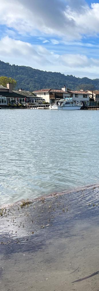
The California Coastal Commission hosts the King Tides Project. While "King Tides" isn't a scientific term, it is used to describe exceptionally high tides that typically occur during a new or full moon. King Tides are the highest high tides of the year, usually one to two feet higher than average high tides. When King Tides occur during floods or storms, water levels can rise even higher and have the potential to cause significant damage to the shoreline and coastal property.
The sea level rise we're experiencing now and will experience in the future is caused primarily by the burning of fossil fuels and increasing concentrations of carbon dioxide in the atmosphere. Carbon dioxide, methane, ozone, nitrous oxide, chlorofluorocarbons, and water vapor are greenhouse gases that act like a blanket around the earth, trapping in heat that would otherwise escape into space. Sea level is rising because land-based glaciers and ice sheets are melting into the oceans and because of thermal expansion of seawater as it warms. Tectonics and other factors can also affect sea levels; however, they generally operate on longer time frames and slower rates.
Increases in global sea levels have been recorded by tide gauges since the late 1800s and more recently by satellites. As an example, sea level has increased by nearly 0.6 feet (7 inches) in San Francisco since the year 1900. In contrast, San Francisco is projected to see a rise of 1.1 to 2.7 feet by 2050 and, by 2100, could experience between 3.4 and 6.9 feet of sea level rise. If extreme melting of the West Antarctic ice sheet occurs, then sea level rise could exceed 10 feet (State of California Sea-Level Rise Guidance, 2018 Update).
King Tides themselves are not related to climate change, but they allow us to experience and visualize what higher sea levels will be like over the next few decades. When you observe the King Tides, imagine seeing these tides (and the associated flooded streets, beaches, and wetlands) every day. Understanding what a King Tide looks like today helps government agencies and the public plan for future sea level rise.
This summary is based on information provided by the California Coastal Commission website. Photographed by John Karachewski in Marin County along Corte Madera Creek at 1:06 pm on January 12, 2024, with Mount Tamalpais in background. GPS coordinates are 37.942211° -122.521317°.


Dr. Abhishek Singh is a Principal Engineer with more than 20 years of experience and is President of INTERA’s Water Resources & Supply Line of Business, where he leads and manages operations, business development, strategic planning for the lob across the United States. He has authored several technical publications and journal articles on groundwater modeling and calibration, stochastic optimization techniques, uncertainty and risk analysis, climate change, and emerging contaminants. Dr. Singh is also the chair of the GRA technical committee and serves on the GRA board of directors.
Chris Bonds is a Senior Engineering Geologist (Specialist) with the California Department of Water Resources (DWR) in Sacramento. Since 2001, he has been involved in a variety of statewide projects including groundwater exploration, management, monitoring, modeling, policy, research, and water transfers. He has over 30 years of professional work experience in the private and public sectors in California, Hawaii, and Alaska and is a Professional Geologist and Certified Hydrogeologist. Chris received two Geology degrees from California State Universities. He has been a member of GRAC since 2010, a Sacramento Branch Officer since 2017, and has presented at numerous GRAC events since 2004.
Dan Bryant, PhD is Woodard & Curran’s National Practice Leader for Emerging Contaminants. Dan has 28 years of geochemistry and in-situ remediation experience that crosses the spectrum from fractured bedrock to unsaturated shallow soil, with contaminants including metals, chlorinated solvents, petroleum hydrocarbons, explosives, PAHs, and emerging contaminants including 1,4-dioxane and PFAS. Dan has three issued and one pending patent for in-situ remedies for metals, chlorinated solvents, and PFAS. Dan is a licensed geologist in Missouri, Georgia, New York, and Indiana. He has bachelor's and master's degrees in geology from the University of Florida, and master’s and Ph.D. degrees in geoscience (with a focus in geochemistry) from Columbia University.
John Karachewski, PhD, retired recently from the California-EPA in Berkeley after serving as geologist for many years in the Geological Support Branch of the Permitting & Corrective Action Division for Hazardous Waste Management. John has conducted geology and environmental projects from Colorado to Alaska to Midway Island and throughout California. He leads numerous geology field trips for the Field Institute and also enjoys teaching at Diablo Valley College. John enjoys photographing landscapes during the magic light of sunrise and sunset. Since 2009, John has written quarterly photo essays for Hydrovisions.
John Stults, PhD is an Environmental Engineer with CDM Smith located in Bellevue Research & Testing Laboratory. He completed his PhD research at Colorado School of Mines, studying the transport mechanisms of PFAS in the vadose zone. He specializes in PFAS transport and treatment assessments, numerical modelling, and scalable data analytics.
Lisa Porta, PE, is a senior water resources engineer and California Water Strategy Lead with Montgomery & Associates, in Sacramento, CA. She has more than 15 years of groundwater modeling and integrated water resources planning experience in California and the Western United States. She specializes in SGMA implementation and supports local water agencies with navigating the increasingly complex regulatory environment with using appropriate data and tools.
Manmeet “Meeta” Pannu, Ph.D., is a Senior Scientist in the Research and Development (R&D) Department of Orange County Water District (OCWD) at Anaheim, CA. Meeta is currently completing research at OCWD related to PFAS. These projects include evaluation of GAC, IX, and alternative adsorbents to remove PFAS from groundwater during wellhead treatment and managed aquifer recharge via in situ adsorption and alternative methods to measure total PFAS in water samples.
Roohi Toosi, PE | President & Principal Engineer at APEX Environmental & Water Resources
Mr. Roohi Toosi, PE is a Board Director and a member of several committees at GRA. Over the course of his career, Mr. Toosi has conducted and managed projects for utilities, school districts, municipalities, military bases, private developers, contractors, farmers, water districts, and large consulting firms.
Todd Jarvis, PhD, is the Director of the Institute for Water and Watersheds, Oregon State University, Corvallis. Todd has 30 years of experience as a hydrogeologist specializing in groundwater development and source water protection with emphasis in fractured rock and karst terranes. With professional licenses as a Certified Engineering Geologist, Certified Water Right Examiner, and Certified Mediator, his interests include transboundary aquifers, environmental conflict resolution, and education in water science and policy.
Tyler Hatch is a Principal Engineer with INTERA. In his previous role, he was part of the Sustainable Groundwater Management Office (SGMO) at the California Department of Water Resources for almost six and a half years. For the last three years, he was a member of the SGMO management team and led the Modeling and Tools Support Section for the last 3 years. One of the major projects Tyler led was the development of the Fine-Grid California Central Valley Groundwater-Surface Water Simulation model (C2VSimFG), which included improvements to simulating land subsidence in the Central Valley.
Dr. Wesley Neely is a Postdoctoral Researcher at Stanford University specializing in the use of land surface displacements for characterizing groundwater dynamics in California’s San Joaquin Valley.