Map & Atlases Lots 296-306
297
296 CAREY, Henry Charles (1793-1879) and Isaac LEA (1792-1886). Geographical, Statistical, and Historical Map of Illinois. [Philadelphia, 1822]. Engraved map of Illinois with hand-coloring in wash and outline, 457 x 563 mm sheet. Three text borders describing the rivers, climate, chief towns, government and history of Illinois. (Short tears to vertical fold, tear repaired upper corner, some minor toning.) THE EARLIEST OBTAINABLE MAP OF ILLINOIS, which had been granted statehood in 1818. The map shows 19 counties in southern Illinois, and the boundary lands to the west. Chicago is named, and the map includes boundary lines of Native American territory in the north. [With:] Two additional maps of Illinois, comprising: Upper Territories of the United States. N.p., ca 1813? Engraved map, 206 x 175 mm sheet. (Mounted to backing board, browned). Bears some similarity to Carey’s map of the same title, though in a smaller format. -- MITCHELL. County Map of the State of Illinois. Philadelphia, 1867. Engraved map with hand-coloring, 378 x 314 mm sheet. With inset plan of Chicago. $400 - 600 296
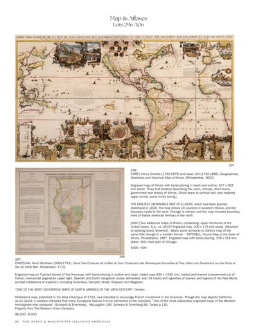
297 CHATELAIN, Henri Abraham (1684-1743). Carte Tres Curieuse de la Mer du Sud. Contenant des Remarques Nouvelles et Tres Utiles non Seulement sur les Ports et Iles de Cette Mer. Amsterdam, 1719. Engraved map on 4 joined sheets of the Americas, with hand-coloring in outline and wash, visible area 820 x 1430 mm, matted and framed (unexamined out of frame), manuscript pagination upper right. Spanish and Dutch navigation routes delineated, over 34 insets and vignettes of scenes and regions of the New World, portrait medallions of explorers, including Columbus, Dampier, Drake, Vespucci and Magellan. “ONE OF THE MOST DECORATIVE MAPS OF NORTH AMERICA OF THE 18TH CENTURY” (Tooley) Chatelain’s map, published in his Atlas Historique of 1719, was intended to encourage French investment in the Americas. Though the map depicts California as an island, a notation indicates that many Europeans believe it to be connected to the mainland. “One of the most elaborately engraved maps of the Western Hemisphere ever produced” (Schwartz & Ehrenberg). McLaughlin 190; Schwarz & Ehrenberg 85; Tooley p.130. Property from The Western Union Company $6,000 - 8,000 96
FINE BOOKS & MANUSCRIPTS INCLUDING AMERICANA


