The Americana & Texiana Collection of Dr. Brant Mittler Lots 193-271
193 [BANGS, Samuel, printer] -- [MEXICAN-AMERICAN WAR]. TAYLOR, Zachary. Quartel general, Exercito de Ocupacion, Corpus Christi, 8 de marzo, de 1846. Orden, num. 30. [Corpus Christi: Samuel Bangs & George W. Fletcher, 1846]. 4to broadside (297 x 202 mm). Printed in Spanish, endorsed in ink verso in a secretarial hand, “77 Z.P. Taylor 23, Mar: 1846.” (Slight toning, creased.) FIRST EDITION IN SPANISH, published the same day as an edition in English printed in the Corpus Christi Gazette Extra. Taylor announces that his army will cross to the other side of the Rio Grande and promised that civilians will be well-treated, and that any provisions will be pad for “a los mejores precios.” The Gazette Extra for March 8 explains: “The orders of General Taylor (No. 30) have been printed in Spanish, and will be circulated among the Mexicans residing along the frontier. Nothing could have taken place better calculated to allay the fears and quiet the apprehensions of the residents along the border than the issuing of this order—explaining the objects of the American Army in advancing upon the frontier.” A SCARCE SAMUEL BANGS IMPRINT FROM CORPUS CHRISTI. Bangs, who was printing the Corpus Christi Gazette, was also working as a job printer for the army and private individuals (see Jenkins 457-459). EXCEEDINGLY RARE: This Spanish-language edition not in Winkler; OCLC locates only one copy at Yale. See Winkler 28 (for the Englishlanguage edition). $400 - 600
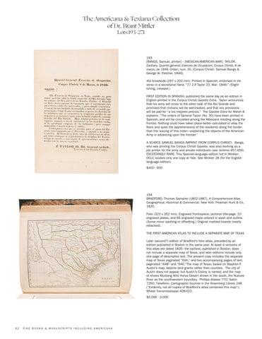
194 BRADFORD, Thomas Gamaliel (1802-1887). A Comprehensive Atlas Geographical, Historical & Commercial. New York: Freeman Hunt & Co, 1835. Folio (323 x 262 mm). Engraved frontispiece, pictorial title-page, 10 engraved plates, and 66 engraved maps colored in wash and outline. (Some minor spotting or offsetting.) Original marbled boards (neatly rebacked). THE FIRST AMERICAN ATLAS TO INCLUDE A SEPARATE MAP OF TEXAS Later (second?) edition of Bradford’s folio atlas, preceded by an edition published in Boston in the same year. At least 4 versions of this atlas are dated 1835: the earliest, published in Boston, does not include a separate map of Texas, and later editions include only one page of descriptive text. The present copy includes the separate map of Texas paginated “64A,” and two accompanying pages of text, paginated “64B” and “64C.”The map of Texas, based on Stephen F. Austin’s map, depicts land grants rather than counties. The city of Austin does not appear, but Austin’s Colony is named, and the map of shows Mustang Wild Horse Desert shown in the south, the Nueces River as the southwestern boundary. Phillips Atlases 770; Sabin 7260; Taliaferro, Cartographic Sources in the Rosenberg Library 248 (“Evidently, not all copies of Bradford’s atlas contained this map”); Wheat Transmississippi 408-410. $2,000 - 3,000
62
FINE BOOKS & MANUSCRIPTS INCLUDING AMERICANA


