South Africa
Krugersdrift Dam Scheme Town River and dam
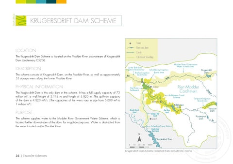
Location
Canals
The Krugersdrift Dam Scheme is located on the Modder River downstream of Krugersdrift Dam (quaternary C52G).
Description The scheme consists of Krugersdrift Dam, on the Modder River, as well as approximately 55 storage weirs along the lower Modder River.
Catchment boundary Modder River Government Water Scheme area
Lower Riet River Irrigation Board area Scholtzburg Irrigation Board area Ritchie Irrigation Board area Riet
Krugersdrift Dam
der
Mod
Ritchie
Physical Information
Koffiefontein
Kalkfontein Dam Ramah Branch Canal
Orange–Riet Canal Luckhoff
The scheme supplies water to the Modder River Government Water Scheme, which is located further downstream of the dam, for irrigation purposes. Water is abstracted from the weirs located on the Modder River.
Riet River Canal
Scheiding Pump Station Vanderkloof Main Canal
N Vanderkloof Dam 0
10
20
30
40 km
Krugersdrift Dam Scheme (adapted from ORASECOM, 2007a)
36 | Transfer Schemes
u it
spr
Purpose
Kalkfontein Canal Scheme
l Kaa
The Krugersdrift Dam is the only dam in the scheme. It has a full supply capacity of 73 million m3, a wall height of 3,114 m and length of 4,820 m. The spillway capacity of the dam is 4,820 m3/s. (The capacities of the weirs vary in size from 5,000 m3 to 1 million m3.)
Riet–Modder Catchment
Jacobsdal
Riet River Settlement
Tierpoort Irrigation Board area
Tierpoort Dam
Riet
Fouriespruit Dam
Riet