

The original edition of this publication was made possible by the support of the Graduate School of Architecture, Planning, and Preservation at Columbia University
New York New York
Copywright © 2022 by the Trustees of Columbia University in the City of New York
All illustrations and layouts © 2022 Urban Magazine
All photographs © 2022
All rights reserved


6

10
BOUND BY TRAGEDY: A REFLECTION ON FLOODING IN NYC SH IVANI PERSAUD
A LETTER FROM THE EDITORS FLUIDITY IN ARCHITECTURE
26
NIKOLAS MICHAEL
14 BE

16 CAN A CYPRIOT SALT MARSH TELL US THE FUTURE OF CLIMATE CHANGE?
BE BE SM
20 WATER IN ALEXANDRIA CALVIN HARRISON BE
GENDER INEQUALITY IN THE CONTEXT OF INDIA: USING PUBLIC TOILETS AS AN EXAMPLE

SHU YANG HUANG
30 SM
ASHLEY COLAS SILENT AFFIRMATION PAINTING
OSAZE STIGLER
Volume 32, Index BE = built environment SM = social movement
32
“FOR THE PLANNERS WHO DID THE BEST THEY COULD”
GERYEL OSORIO GODOY
36
GHOST MONUMENTS: AN ESSAY ON RESILIENCE AND URBAN MEMORY IN NICARAGUA

OSCAR M CABALLERO APPROACHING ONE YEAR WITHOUT EAST RIVER PARK
44 46 54
EMILY SANDSTROM
DRAWINGS AS CONSTRUCTION SITES

K ADEN BEILMAN
ECOLOGICAL RESTORATION AS ECO-ART: THE ARTISTIC CRUSADE TO REMEDIATE OUR WATERBODIES

NATALIE BARTFAY
58
CLIMATE ADAPTATION
T
PUERTO RICO STUDIO

SM (DE)C (DE)C (DE)C T
(DE)C = (de)construction
= transformation
T

6
Letter from the editors

AS ONE CAN SEE FROM THE FRONT COVER, URBAN HAS ENTERED A NEW ERA. MOVING AWAY FROM THE RIGIDITY OF OUR FIELD, WE HAVE DECIDED TO EXPLORE THE INTERSECTIONS BETWEEN PLANNING AND OTHER ASPECTS OF LIFE. HENCE, WE BRING YOU “FLUIDITY.”
This issue of Urban Magazine seeks to break down the concrete walls of perceived “urbanism” and the urban planning field at large as something far less binary. Planning can no longer just encompass policy, ethnography, or landscape architecture. From changing environments, to social infrastructure, to individual experience, fluidity is a feeling, a process, a method. This past year, in New York and beyond, was the 10th anniversary since Hurricane Sandy, one year since Tropical Storm Ida, a year in which we all moved back into the “real” world amidst a global pandemic, and a year where we are learning to survive the tensions within our city built from racism and structural power. As new feelings emerge, as social movements tear down our ideas of injustice and traditional binaries, as environmental disasters leave us in horror, now more than ever, urbanism must be fluid.
Fluidity has the power to be destructive, yet soft; transformative, yet always becoming. We see fluidity as operating without restrictions and boundaries. At a time when it is essential to reimagine everything in our world, design has to move away from the isolation of our individual fields of planning, architecture, and urban design into professions that prioritize collaboration between people, place, and practice. Welcoming movement, flexibility, and abstraction, the work portrayed in this issue challenges planning’s involvement in the environments that shape our world. As you move through these pages, submissions are placed into transferable sub-themes such as built environment, social movement, (de)construction and transformation which illustrate the breadth of past, present, and future issues that planning should explore.
As an entirely new team of editors, we are proud. We would like to thank our students, professionals, and artists for their provocative submissions on topics that have been extremely taboo in our respective fields. We encourage everyone who crosses paths with this volume of the magazine to consider the many differences that come with the current theme. Our incorporation of conversations, poems, and art surrounding gender, environments, water, and different paths of life are structured in a way that helps to redefine planning, and ultimately, to extend planning past its bureaucratic boundaries. Recent decades have afforded us a variety of meditations on this subject, and more specifically, the deeply complex politics that infiltrate urbanism. We ask of you, while reading this issue, to bask in the ambiance of brilliance, poise, and the intricacies of experience.
EDITORS OF VOL. 32, KYLIEL, ESHTI, GABBY, ROB, OLIVIA, FELIPE, ETHAN, MATTHEW, & ALYANA
7
LETTER FROM THE
EDITORS

“For those unaffected, Ida was just another broadcasted natural disaster.
“For those unaffected, Ida was just another broadcasted natural disaster.
But for those who were, Ida changed their entire lives.”
But for those who were, Ida changed their entire lives.”

10 FLUIDITY AS BUILT ENVIROMENT
Bound by Tragedy: One Neighborhood’s Self-Reliance in Ida’s Aftermath
Shivani Persaud
The cycle of major events receiving attention and news coverage, only to fade away when another major event occurs, has no real end in sight. This makes televised events forgettable, just distant memories with fleeting importance.
For those unaffected, Ida was just another broadcasted natural disaster. But for those who were, Ida changed their entire lives.
In October 2021, almost a month after one of New York City’s most devastating floods, Domingo Alexius “Alex” Gomes was still rebuilding his life after losing everything in his Hollis, Queens basement home.
“For five to six years we were living there, and nothing like this ever happened before,” Gomes said.
Gomes and his wife were at work the night of Sept. 1, 2021, when he received a call from his 8-year-old son, Anthony. A severe storm caused water to pour into their home at an “intolerable” rate, and within a few hours, the water inside went from 2 feet to over 5 feet high. They rushed home and tried to bail out the water with buckets, he said. Ultimately they had to abandon the buckets and save their lives.

Despite growing up on 184 street, I met Gomes, my neighbor, only after the flood.
He came to my parents’ home one night and asked to borrow some blankets. His family had been sleeping on the floor since the night they lost everything to the flood.
Gomes and his family were lucky compared to another family who lived mere feet away.
I was in the sixth grade when Hurricane
Sandy hit New York City in 2012. I vaguely remember being home from school, watching the news with my parents and listening to the howling wind blow down trees and power lines.
But my neighborhood didn’t flood.
Seven years later, I learned about the severity of hurricanes when I moved to Orlando to attend the University of
FLUIDITY AS BUILT ENVIROMENT 11
Central Florida. When the university announced that it would close because of Hurricane Dorian in 2019, I hightailed it to my Hollis home and waited out the storm that never came. I never expected my childhood neighborhood to become the target of a hurricane just two years later.
The National Hurricane Center forecasted that Hurricane Ida would reach the northeast United States at the end of August 2021, bringing heavy rain and winds. Unfazed, I figured it would be nothing more than a summer storm. My sister and I had been basking in Orlando’s humidity the night of Sept. 1 when my mother video-called us. The screen was pitch black and all we could hear was a continuous roar.
“It’s raining! Do you see how high this thing is?” my mother said, panning the phone to show us our street. Unbelievably, it had become a river, only illuminated by streetlights.
We saw cars almost submerged at the head of the street, where there was a dip. A manhole cover had popped and a raging fountain had formed. My mother moved to our backyard, where my father was walking through water already a foot deep.
Throughout the night, I watched Facebook Live videos and pored over photos from my Hollis neighbors of the still-rising water. Just next door to our home, floodwaters rushed into my neighbor’s basement with such force, they broke the door. Four to five feet of water easily poured in.
The next morning, I called my mother. Not only did the rain flood our neighborhood so destructively that homes and residential basements were now unlivable, but for one home in the street just behind ours, the destruction was irreversible.
Premattie and Nicholas Ramskiret, a mother and son known as “Tara” and “Nick” to the neighborhood, had lost their lives.
“The water came in and they couldn’t get out of the basement,” my mother said, and I started tearing up. “They drowned. Next door, their basement is completely gone. I’m going to walk around and see how everyone is.”
Not long after our call, Gov. Kathy Hochul, Sen. Chuck Schumer, and Mayor Bill de Blasio held a press conference in front of the house where the Ramskirets had lived. They offered their condolences, blamed the floods on climate change, and left.
For the next two days, it was apparent that there was no city, state, or federal aid on the way. Frustrated, I called one of my friends, Movina Seepersaud, on Friday evening and asked her what we could do.

Saturday morning, we mobilized.
A Facebook post advertising our makeshift flood relief drive resulted in overflowing donations. All day, people showed up to my Hollis home to give cleaning supplies, bedding, personal care items, pantry items, and clothes. Our humble backyard became a haven of resources for the neighborhood.

Seepersaud coordinated the drive in my absence, including organizing supply distribution and hot meal sponsors and walking around the neighborhood to ask each family what they needed.
“Being a part of the drive was bittersweet because we were able to bring them things like those supplies and the hot meals because they weren’t able to cook,” Seepersaud said. “Some of them didn’t have electricity and gas, so it was nice on our part to feel like we were helping in some way, but it was also painful to see.”
On Labor Day, I flew to New York and witnessed an entire neighborhood operating as a family, bound by a common tragedy. The Federal Emergency Management Agency did not show up during the first week, and residents pushed through without any financial relief. What was planned to be a one-day donation-driven effort became a flood relief mission over five days.
12 SHIVANI PERSAUD
“I saw families who lost everything,” Seepersaud said. “They didn’t have anyone around or anyone to stay with … mentally I can’t even think about what they’re going through. We can’t do this on our own, they need government aid. They still need proper housing.”
Kishore Seunarine, a community organizer, volunteered to distribute items at the drive. The reality of the situation lay in what people chose to take, he said.
“People passed hot food to pick up a bottle of bleach,” he said. “I saw people’s entire lives compressed into a dumpster.” Many families were leaving either because the flood had severely damaged their homes, or their landlords were afraid of receiving an illegal basement residence violation. But no one had a plan.
“It’s figuring out how to find your life again,” Amrisa Bhagwandin said. “We have undocumented tenants who aren’t able to apply for FEMA aid and they’re more at a giant loss of what to do. Red Cross has provided hotels for people but some of them are far.”
Bhagwandin and her family had lived in the area since the 1990s and witnessed houses in the area weakening as a result of long-term construction and another major flood that happened in 2003.
“Rebuilding your life takes so long,” she said. “You’re not even finished with your first or second loss and have to start on your third or fourth … Our house is leaning and literally tilting. FEMA declared our home unlivable.”
I walked down the street on Sept. 8 to deliver lunch to my neighbors, Amrisa Bhagwandin and her family, and was shocked to see their home in disarray. They were moving out.


ONE YEAR LATER, THE BOTTLES OF BLEACH AND PILES OF GARBAGE BAGS ARE LONG GONE. THE PACKAGED MEALS HAVE ALL BEEN CONSUMED. THE WATER HAS RECEDED, AND NO SUBSTANTIAL FINANCIAL ASSISTANCE HAS BEEN DOLED OUT. THE HOME OF THE RAMSKIRETS IS NO LONGER HIDDEN FROM PUBLIC VIEW, AND THE WALL THAT CAVED IN IS NOW REPAIRED. MANY FAMILIES HAVE LEFT THE AREA, TAKING WITH THEM LIFELONG MEMORIES AND THE GRIEF FROM THAT DISASTROUS NIGHT.
BUT A NEIGHBORHOOD IS EVEN CLOSER NOW, BOUND BY TRAGEDY.
“WE LITERALLY ONLY HAVE EACH OTHER,” BHAGWANDIN SAID.
13
SHIVANI PERSAUD
Fluidity in architecture
ASHLEY COLAS
When I think of fluidity, I think of flawless adaptability. It is no question that the built environment has gone through many extensive changes. Most of these changes could have easily gone unnoticed if it hadn’t been for the rigorous research following these constant developmental stages.

THE INTERACTION OF ARCHITECTURE, SPACE, AND PERSON PLAYS A PIVOTAL ROLE IN THE BUILT ENVIRONMENT. HOWEVER, A POWERFUL RELATIONSHIP WITHIN THIS EXPERIENCE THAT’S OFTEN DISREGARDED IS ARCHITECTURE AND LANDSCAPE.

14 FLUIDITY AS BUILT ENVIROMENT
In a contextual sense, fluid architecture is based on flexibility and organically shaped masses. Oftentimes architectural structures are able to stand alone. I’d refer to those stand-alone buildings as aromatic. Undisturbed by the context of other “distractions”; a statement on its own. They’re strong enough to withstand the typical “cliche'' of great architectural works in relation to their landscapes. They encourage and support one another and look good doing just that. From miles away, you may witness the most boisterous pairing In all but one instance the coupling is fluid; not in context but in the scheme.
I encourage commuters to take a good look at the buildings they pass on their travels. I also encourage you to envision that building or space without its landscape. Ask yourself, whether the landscape compliments or distracts from the structure or vice versa. Architects and landscape designers alike collaborate to create these fluid links. When speaking of these relationships, we should first identify the characteristics of fluidity in the architecture. Fluidity in architecture refers to seamless movement; a flow. Flow can be defined as an experience; a spatial anomaly that can be both “unnatural” and exceptional. Flow and fluidity collaborate to create cohesive environments for the human experience. Frank Lloyd Wright once said, “The good building is not one that hurts the landscape, but one which makes the landscape more beautiful than it was before the building was built.”
CENTURIES OF TIMELESS WORKS CAN SPEAK FOR THE FLUID RELATIONSHIP BETWEEN LANDSCAPE AND ARCHITECTURAL DESIGN. WHAT IS THE PALACE OF VERSAILLE WITHOUT ITS GARDENS; NEW YORK CITY WITHOUT CENTRAL PARK; OR SANSSOUCI PALACE WITHOUT ITS LAYERED TERRACE? FLUIDITY IN THE ARCHITECTURAL LANDSCAPE ALLOWS FOR A COMFORTABLE HUMAN EXPERIENCE.

15 FLUIDITY AS BUILT ENVIROMENT
Can a Cypriot Salt Marsh Tell Us the Future of Climate Change?
NIKOLAS MICHAEL
There are worse places to get your car stuck than Akrotiri Salt Marsh. The briny smell of salt in the air, a view of the lake that looks like a mirage, and the shorebirds almost make you forget you are completely alone, except for the scary British Air Force base, which you absolutely should not walk alone towards. I made the mistake of trusting Google Maps too much – blindly turning down a road that existed on paper (or screen, I guess), but as my dad would explain to me when I recounted this story with him a few months later (I was too embarrassed to do it right away), sometimes you must look with your eyes. In Cyprus, this road might exist in the summer when the island swells in size with the tourists that Google Maps directions are made for, but in February? In February, the winter rain and wind made the “road” into a muddy sand pit, and my tiny car with twowheel drive and 100 thousand miles was absolutely, undeniably stuck.
The car sunk deeper into the sand with every push of the gas pedal, my only mode of transportation and most of my worldly possessions getting closer to becoming yet another artifact on an island full of them. I am in Cyprus, and in Akrotiri specifically, to study climate change.
Which, if you think about it, is a really innocuous term for a phenomenon that will dry out and heat up a place with millennia of history to the point of becoming uninhabitable. The already dry island is facing down the barrel of water shortages that we will try to stave off by pulling drinkable water out of the sea while summer air regularly heats to 120 degrees Fahrenheit.
It seems an impossible situation, both the climate situation of the island and my smaller issue of being stuck in a salt flat in a British military base (who have occupied the island for centuries, which is not the point of this article but give us back our land). As my tires uselessly spin and kick up more dirt to bury me in, I’m anxiously fixated on the future. How am I going to get the hell out of this salt flat? And how is the island where I learned how to play Uno and Hide and Seek going to get through a crisis I have seen play out in charts, but now am living firsthand with every breath of burning olive trees and withering reedbeds. Akrotiri, and specifically the dirt being kicked up by my ’08 Mazda, was the subject of a recent study by Calian J. Hazell, Matthew J.Pound, and Emma P.Hocking from Northumbria University, studying, like

16 FLUIDITY AS BUILT ENVIROMENT
me, climate change. But unlike me, their eyes were fixed firmly on the past, searching for evidence of a traumatic climatic event that set off the Late Bronze Age collapse, a sociopolitical calamity that wiped out ancient civilizations all across the Eastern Mediterranean and Middle East. There are many theories as to what happened, my favorite of which involves the ominously named Sea People, but these researchers were setting out to try and find evidence of climatic shifts that could have triggered this collapse.
How can researchers in 2022 try and figure out what happened millennia ago? Well, just as my car’s wheels spinning helped me find old shells and even a cloth base from a baseball game, scientists can take cores of the soil and analyze it to look for key environmental indicators that they can use as puzzle pieces. They can do this because soil acts as a natural record keeper, and the deeper in the soil you go, the further back in time you can get. Scientists can also do this with ice, which is how we know modern, anthropogenic climate change is different and more rapid from climate change in the past.
SO WHY TAKE SOIL CORES FROM THIS SALT MARSH FROM A TINY ISLAND IN THE MIDDLE OF THE MEDITERRANEAN?
Other than this being a convenient excuse to talk about my personal life, the Akrotiri Salt Marsh is an extremely sensitive ecosystem that is very responsive to changes in water availability – as a marsh on an arid island, it lives a very precipitous existence. And so, just as scientists studying the marsh in its current form can get a good idea of the fact that it’s getting drier on the island because the marsh is getting smaller and smaller, scientists studying the past can look at the soil core samples to see when the marsh was robust, and when it was more wooded or even arid, which indicates less water available on the island.
To figure this out, they sent these soil core samples to a radiocarbon dating lab in Gliwice, Poland, which, and maybe this is an unnecessary detail, but this lab is actually down the street from my grandmother’s house. In this lab, they analyzed the soil cores using pollen that has been trapped in the soil for thousands of years, and diatoms, fossils of singlecell, algae-like organisms. The diatoms and pollen
act as proxies, and give scientists an understanding of what kind of ecosystems were around the marsh at a given time scale – for example, if they found evidence of cereal crop pollen, then scientists can state pretty confidently that at that time period, there was some human farming going on. This multiproxy analysis lets scientists draw correlations from multiple sources, allowing them to compare different variables and come up with a much more complete picture.
What this analysis of Akrotiri found was consistent with the hypothesis of climate change being associated with the late Bronze age collapse. Both pollen and diatom analysis unearthed (ha) a sudden shift from a marshy environment with evidence of human cultivation of cereal plants, to a more arid environment with no evidence of human cultivation. Both proxies point to the same time, about 4,200 years ago, consistent with hypothesized peak aridity during the Bronze Age. Both proxies also found a weaker correlation around 3,200 years ago, which is a hypothesized second event that contributed to the Late Bronze Age collapse. However, this analysis, paired with archaeological evidence of destroyed monuments and abandoned towns around Cyprus at this time, strongly suggests a connection between the climate changing and a change in land use by Bronze Age people in Cyprus. What these cores tell us is that the Akrotiri Salt Marsh expands and contracts based on water availability, and with every thousand-year breath, we can infer a story from what we read from the soil.
Today, I am frustrated by loose sand getting stuck between my tires, my engine, and my socks. Today, the marsh is telling me it is contracting, shrinking under pressure from carbon magnified heat, from a sky with what used to be rainclouds passing by without a drizzle, from the greedy developers that my people’s “independence” has freed up to build our ancestral shores and wetlands into attractions for tourists trying to soak up some sun before heading back to London, Moscow, or Berlin. Yesterday, (or more accurately, 4,200ish years ago), the marsh contracted as it did now, and the same loose sand frustrated the people living near it as it frustrates me.
17
FLUIDITY AS BUILT ENVIROMENT
DID THEY KNOW THAT THE SAND WAS JUST ONE SYMPTOM OF A LARGER CALAMITY? OR DID THEY, LIKE ME, FIND IT AN ANNOYING INCONVENIENCE THAT IS STOPPING THEM FROM GOING TO THEIR AUNTIE’S HOUSE FOR DINNER?
The scientists drilling these cores cannot say for sure; they set out to see if they could find evidence that the climate did change before one of the most mysterious and disastrous civilizational collapses in human history. They found that evidence, and so we add more proof to the pile as we try to unravel what, exactly, happened. The current hypothesis, supported by this research, is that either climate change completely upended systems of cultivation and human society or that human society upended vegetation patterns through our own methods.
Through the kindness of a British dirt biking soldier and his extremely pushy, but ultimately very nice, mother, my car eventually got pulled out of the mud and onto a (real) road. The dirt that snared my car got washed off at a Limassol gas station, so I could avoid the indignity of admitting to my family that I got stuck where they knew not to drive in the winter. Presumably, that dirt eventually washed back into the ocean – maybe it will end up back in the salt marsh, maybe not.
WHEN SCIENTISTS YEARS FROM NOW CORE THAT DIRT, THEY WILL NOT FIND EVIDENCE OF MY SELF-MADE PREDICAMENT, BUT THEY WILL SEE EVIDENCE OF THE MARSH CONTRACTING RAPIDLY. I HOPE THEY FIND A MARSH AT ALL.

18 NIKOLAS MICHAEL

NIKOLAS MICHAEL 19
WATER IN ALEXANDRIA CALVIN HARRISON
For most people, living in a city means giving up space i.e. sharing cramped quarters with family or roommates. Faced with this scarcity, urban dwellers look outside of their homes for space to relax or socialize. This “third space” takes many forms in cities across the world: parks, cafes, barber shops to name a few. Alexandria, where millions of residents are crowded into a narrow strip of city along the Mediterranean, is no exception to this. There, the city’s waterfront, known as the “Corniche,” serves as an important third space for residents.
For most people, living in a city means giving up space i.e. sharing cramped quar- ters with family or roommates. Faced with this scarcity, urban dwellers look out- side of their homes for space to relax or socialize. This “third space” takes many forms in cities across the world: parks, cafes, barber shops to name a few. Alex- andria, where millions of residents are crowded into a narrow strip of city along the Mediterranean, is no exception to this. There, the city’s waterfront, known as the “Corniche,” serves as an important third space for residents.

As the blue waters of the Mediterranean lap up against concrete revetments, Alexandrians flow in and out of the public space of the Corniche. They stop briefly before catching a bus or a tram. If they have more time, or are going a shorter distance, they stroll – leisurely or quickly – to their destination. Others stop to sit, alone, with friends, or with loved ones. This is a space that is at once intensely public and intimately private. Among crowds coming from all over the city, one can have more privacy than in a family home or neighborhood filled with prying eyes. The sea, too, is ambivalent, at once an unforgettable focal point and a tired background.
As the blue waters of the Mediterranean lap up against concrete revetments, Al- exandrians flow in and out of the public space of the Corniche. They stop briefly before catching a bus or a tram. If they have more time, or are going a shorter distance, they stroll – leisurely or quickly – to their destination. Others stop to sit, alone, with friends, or with loved ones. This is a space that is at once intensely public and intimately private. Among crowds coming from all over the city, one can have more privacy than in a family home or neighborhood filled with prying eyes. The sea, too, is ambivalent, at once an unforgettable focal point and a tired background.
This series of photos explores how Alexandrians use their seaside public space. The Corniche is a seam between the waves of the Mediterranean and the masses of people moving throughout the city each day. These photos capture the mo- ments that people are able to steal for themselves in this space that is at once land and sea, public and private.
This series of photos explores how Alexandrians use their seaside public space. The Corniche is a seam between the waves of the Mediterranean and the masses of people moving throughout the city each day. These photos capture the moments that people are able to steal for themselves in this space that is at once land and sea, public and private.
20 FLUIDITY AS BUILT ENVIROMENT

21 FLUIDITY AS BUILT ENVIROMENT


22 CALVIN HARRISON


23 CALVIN HARRISON

Gender Inequality in the Urban Context of India: A Study of Public toilets

 Shuyang Huang
India is a large and shifting political territory that has a complex and varied history. Indian women are often regarded and treated as appendages of men and sometimes even slaves of a patriarchal, caste-bound society (Jayawardena 2016, 225). During the post- colonial time, movements for women's emancipation emerged together with the resistance against imperialism. Jawaharlal Nehru, the first prime minister of India, was one of the leaders who fought against social evils and for women’s rights. During his administration, he advocated strongly for women to have access to educational institutions, and to discover options for working outside the household (Jayawardena 2016, 284). However, those movements were mainly led by men in large cities and rather reinforced “patriarchy and the class system” (Jayawardena 2016, 262). A major reason these drastic social reforms failed to reach their full potential was that the inequality around gender roles and expectations was still deeply ingrained in India at that time. In this article, I discuss a snippet of this entrenched inequality by zooming in on women’s presence and activities in public spaces, and more specifically, their use of public sanitation facilities.
26 FLUIDITY AS SOCIAL MOVEMENT
Figure 1: Public toilets in the city of Varanasi in India (Ramani n.d.)
THE EMERGENCE OF PUBLIC TOILETS IN INDIA

“The day every one of us gets a toilet to use, I shall know that our country has reached the pinnacle of progress.”Jawaharlal Nehru (1889 – 1964) (Sulabh International, n.d.)
The public toilets in India sprouted from the emerging standards of hygiene in the West. For a long time, public spaces were treated as a supplement to domestic spaces, where “impure” acts could be performed without shame (Doron and Raja 2015). The imposition of caste systems led to the creation of these Hindi rituals where people were “naturally” divided into hierarchical groups known as “castes,” and therefore, these spaces that were designated to deal with “impurity” emerged subsequently from the politics of these caste systems (Jayawardena 2016, 222). People in different castes had their own social duties, with those in the highest castes responsible for religious affairs that were deemed “pure”, and those in the lowest caste for impure and “polluted” tasks
such as cleaning human waste (Phadke, Khan, and Ranade 2011, 82). The excretory function of the human body was labeled as the highest in the order of pollution (Phadke, Khan, and Ranade 2011, 82), and people would be “defiled” if they touched the excrement, becoming the ritually “untouchable” (Douglas and Kalender 1956, 125). Defecation was thus invariably connected with the idea of “shame and revulsion.” In some areas of India, simply having a toilet in the house was considered sacrilegious (Phadke, Khan, and Ranade 2011, 82). This unfair yet powerful dichotomy gave birth to a highly restricted and hierarchical social order in favor of the powerful and the rich.
Meanwhile, public space was defined differently in Western societies. It was simply the opposite of private space such that there should be a clear boundary between activities allowable in the public versus private space (Ali 2001). By definition, the public space was a shared space ordered and regulated by civic responsibility. These regulations ensured that the space was recreational and increased the convenience and quality of people’s lives by providing rooms for activities that did not “belong to the inside (family/kinship/community)” (Chakrabarty 1992). Therefore, it was not surprising that the British invaders were immediately shocked by the disorderliness and chaos of public space as they arrived in India: the streets were “like rituals of washing, changing, sleeping, urinating, and cooking” (Edensor 1998), and the disorderliness in the streets was “a promiscuous use of public space” (Chakrabarty 1992, 67). There was practically no division placed between the functions of public and private space, especially among the poor and those from lower castes. Therefore, the western colonial rulers at that time decided to “impose an alternative metropolitan spatial disorder” to fight against primitive chaos (Edensor
1998). Subsequently, with the advent of globalization and modernity, the traditional Indian culture and European modern thinking co-existed uncomfortably and problematically in postcolonial India. This contradiction did not stop even during the post-colonization period when people started to share a “collective desire” for personal hygiene and public orderliness in the public space and to value the “pleasures of privacy” (Chakrabarty 1992, 77). As the definition of public space changed, open defecation was labeled cancer to society. Therefore, the building of in-house toilets and the promotion of public toilets emerged as practical solutions to this public health challenge. As mentioned in the beginning quote of this section, in Nehru’s mind, the toilets were a symbol of civilization and social progress. However, although some public toilets were built, not many people could afford to build toilets in their domestic spaces due to poverty.
In 1970, a non-governmental organization called Sulabh Shauchalaya Sansthan (now Sulabh International Social Service Organization) was founded to further address the problem of inadequate public sanitation facilities in India. At the same time, a movement called Sulabh Shauchalaya (“twin-pit pour-flush toilet”) started to promote a low-cost and easyto-assemble toilet in India. In 1974, the organization built the first public toilet, bath, and urinals complex in Patna, Bihar, India (Sulabh International, n.d.). This marked the national public awareness of public health and hygiene. However, although the movements were wellintended to promote public goods, their design and disproportionate focus on men further exacerbated the inequality between men and women in their activities in the public.
27 FLUIDITY AS SOCIAL MOVEMENT
THE DESIGN OF PUBLIC TOILETS AND HOW THEY EXCLUDED WOMEN IN INDIA
The access to public toilets encapsulated access to the public domain and modernity. However, inequality emerged as to who had carefree access to the space: the toilets were designed to exclude women. This inequality was mainly evident in three aspects: lack of privacy, inadequate restrooms, and lack of services for women with children.
First, the toilets provided no privacy for women who needed them. Since they were designed as a solution to open defecation, the location of the public toilets was mainly next to the public spaces where people defecated, for instance, next to the rail tracks, the street, or the entrance of a community. According to the report made by ActionAid Association in 2017, more than 35 percent of the 229 public toilets surveyed in Delhi did not have a separate section for women, and 28 percent of public toilets did not have doors (ActionAid India 2017). Figure 1 shows a typical public toilet in an urban area in a community. Although there were no signs on the toilet, this toilet was evidently purposed only for men to urinate. The drain was placed directly next to the wall, which provided no space for women to squat down. Ironically, products like the “magic cone” were invented to “solve” this embarrassing situation, which enabled females to urinate in a standing position.
The second condition was the overall lack of toilets for women even when they were designed to ensure privacy. The plan of the public toilet, bath, and health center (Figure 2) in Hajiali Circle, Mumbai, designed by the Sulabh International Social Service Organization, was a direct manifestation of inequality between men and women (Sulabh International, n.d.). The men’s toilets were approximately two times larger than the women’s toilets,
where there were seven spots for men to defecate and ten spots for them to urinate while only five spots for women.
The third condition was that the design of the public restroom provided no support for mothers with children. In India, women were assumed to take the responsibility of rearing and feeding their children. However, no place was designed for women to breastfeed their children, no baby seats were provided for the children to stay in, and almost no diaperchanging tables were present in public toilets. The book Why Loiter?: Women and Risk on Mumbai Streets mentioned an interview the writers conducted with a retailing manager for diaper-changing tables. It was quite ironic to hear from the manager that even the toilet in his own shop did not have such tables installed. In his words, “we don’t encourage such activities in our shop” (Phadke, Khan, and Ranade 2011, 228).
BEHIND THE EXCLUSION
A public toilet should have a crucial characteristic — publicness, which ensures inclusivity and unbiasedness to different groups of people. However, what happened when public toilets became prevalent in India raised the question of how they, as a supposedly gender-neutral space, became a source of exclusiveness for women. In this section, I attempt to unpack the social and cultural reasons behind the externalization of gender inequality in the usage of public toilets. First, there was a lack of female perspective in the design of the toilet. A thoughtful design of toilets in public spaces was in fact overlooked by the experts for a long time. In the urban planning, architecture, or even environment-behavior literature, people’s
needs for the toilet had been “paid short shrift” (Anthony and Dufresne 2007). Consequently, women, who were seldom employed in male-dominated professions had even fewer opportunities to express their needs through active participation in the actual design of the toilets.

The second reason was that the social norm of India intensified gender inequality in public space. The ritual norm deeply embedded in the caste structure was detrimental to women and intensified social inequality through the propaganda that women’s secretion (periodical menstruation, ovulation, and lactation) was shameful (Phadke, Khan, and Ranade 2011, 82). Not only did this process solidify the domination status of men, but it also led to the internalization of selfstereotyping among women. In Phadke’s book, she mentioned an interviewee who refused to “ask for a toilet when there are men around,” and she “either made some other excused or just held it” because of the embarrassment (Phadke, Khan, and Ranade 2011, 82).
Women’s toilets need more maintenance than men’s toilets so that public toilets for women in Mumbai shut down at 9 pm to reduce the maintenance cost. However, the authorities and society passed that structural inability onto women and blamed them for being outside at night. Those authorities declared that “respectable women have no business being out in public after dark”(Phadke, Ranade, and Khan 2013). Men occupied the women’s toilet during the time when they thought women should not be outside. This social yoke still shackled women and shrunk the living space and time for women in the public realm, which also intensified women’s inferior status in society.
28 SHUYANG HUANG
The third reason was the sense of insecurity set a phycological barrier for women. Potential violence and harassment would result in hazardous consequences such as loss of life. The daily life of women in those areas with inadequate public toilets was unknown and insecure. There were women who got attacked and gang-raped even today because of open defecation. Even those women who had access to the toilet could not escape from the danger.
IN CONCLUSION, THIS ARTICLE ATTEMPTS TO USE THE PUBLIC TOILET AS A MINIATURE OF THE BROADER ISSUES AROUND SOCIAL AND GENDER INEQUALITY IN INDIA. DURING THE POST- COLONIAL TIME, GOVERNMENTAL AUTHORITIES BEGAN TO ADDRESS THE ISSUE OF GENDER INEQUALITY. HOWEVER, THE VOICE OF WOMEN WAS OVERLOOKED IN THE DECISION-MAKING PROCESS, ESPECIALLY SINCE THEIR NEEDS AND REQUIREMENTS FOR PUBLIC TOILETS WERE IGNORED IN THE DESIGN PROCESS OF THE PUBLIC TOILET. IT WAS AN EXTERNALIZATION OF THE DEEPLY ROOTED SOCIAL NORM OF GENDER INEQUALITY IN THE CULTURE OF INDIA. THUS, GENDER INEQUALITY AS MANIFESTED IN THE USE OF PUBLIC TOILETS CALLS FOR LARGER-SCALE PUBLIC AND SOCIAL INTERVENTIONS BEYOND CHANGES IN THE DESIGN OF THE TOILETS.

1 Two teenage girls were gang-raped in New Delhi when defecating outside on May 31st, 2014. News Website: https://www.wbur.org/cognoscenti/2014/06/25/human-rights-gang-rape-sharmila-l-murthy
2 A five-year girl was raped inside a public toilet in New Delhi on Feb 6th, 2019. News Website: https://indianexpress.com/article/cities/delhi/delhi-5-year-old-raped-by-sanitation-worker-inside-publictoilet-5579013/
Figure 2: Plan for the public toilet in Hajiali Circle, Mumbai (Sulabh International, n.d.)
29 SHUYANG HUANG
Silent Affirmation Painting

Osaze Stigler
FREEDOM AND OPENNESS CAN FEEL SCARY. WE’RE CONSISTENTLY PLACED IN SO MANY BOXES, THAT MERELY EXISTING WITHIN OUR OWN BODIES WITHOUT SHAME FEELS LIKE A TRIUMPHANT ACT. IT’S ALL ABOUT THE ABILITY TO FIRSTLY FLOW SO DEEPLY INTO YOURSELF, THAT YOUR PRESENCE IN THE WORLD UNCONTROLLABLY MAKES WAVES WITHOUT HESITATION OR RESISTANCE. EXISTING FREELY SHOULD FEEL CALM. IT SHOULD FEEL AFFIRMED, LIKE EVERYTHING IN THE WORLD IS DESIRING YOU TO BE YOUR MOST AUTHENTIC SELF.
FREEDOM AND OPENNESS CAN FEEL SCARY. WE’RE CONSISTENTLY PLACED IN SO MANY BOXES, THAT MERELY EXISTING WITHIN OUR OWN BODIES WITHOUT SHAME FEELS LIKE A TRIUMPHANT ACT. IT’S ALL ABOUT THE ABILITY TO FIRSTLY FLOW SO DEEPLY INTO YOURSELF, THAT YOUR PRESENCE IN THE WORLD UNCONTROLLABLY MAKES WAVES WITHOUT HESITATION OR RESISTANCE. EXISTING FREELY SHOULD FEEL CALM. IT SHOULD FEEL AFFIRMED, LIKE EVERYTHING IN THE WORLD IS DESIRING YOU TO BE YOUR MOST AUTHENTIC SELF.
30 FLUIDITY AS SOCIAL MOVEMENT

FOR THE PLANNERS WHO DID THE BEST THEY COULD
Geryel Osorio Godoy
THIS POEM TAKES PLACE THIRTEEN YEARS INTO YOUR FUTURE.
on a building, across the water spills a shoulder on the street
—Aja Monet

today Lucy is not dead today Anarcha is not dead today Betsey is not dead today they’re 15 water falls around them
Lucy holds her breath for exactly 29 or 31 seconds stretches thick above each ripple coming up just below the surface takes a peak at her sisters floats extends smiles the water is not dry yet Anarcha taller than all her joys presses heel, sole, ball on a limb balances with eyes closed trusts it stands still to catch her if she falls Betsey laid whole on the ground forehead glistening is somebody’s daughter again too
they, once bruised, once forgotten each will float a cahaba lily and once the sun rests at a distance in the south of summer with yellow on their skin will set home the river will follow
32
today they do not know who you are Sims did not exist the lawn holds wildflowers in this instance
you are anyone they want you to be architect, designer, teacher, womxn, man it ’s all the same you do not bring the storm with you

they will grow to be whoever they wish to be lesbian, gay, trans, queer, none or all you, pen and paper, listen to the notes on hymns said in between a choir distant yet near
your god offers no solutions except a measure of honesty
remember the tide came at you too remember the fires you put out can we plan at a distance?
what do you value?
who do you take with you and leave behind?
what courage it takes to play God and ignore her instructions.
THIS POEM WAS INSPIRED BY A CONVERSATION WITH MICHELLE BROWDER, AN ARTIST, HISTORIAN, AND ACTIVIST RESIDING IN MONTGOMERY. MADE POSSIBLE ON A RECENT TRAVEL TO ALABAMA THROUGH THE ADVANCED JOINT HISTORIC PRESERVATION/URBAN PLANNING STUDIO. THE AUTHOR IMAGINES THREE WOMEN, WHO WERE ENSLAVED AND UNWILLINGLY MEDICALLY EXPERIMENTED ON IN THE 1800S, ALIVE AND YOUNG AND WELL IN A NEAR FICTIONAL FUTURE WHERE THEY ARE CELEBRATING AND AT PEACE. THE AUTHOR CENTERS THEIR SISTERHOOD AND JOY BUT, ALSO QUESTIONS THE ROLE OF PLANNERS IN A FUTURE WHERE BLACK PEOPLE ARE NOT MURDERED AND INVITES THEM TO THINK ABOUT THE FLUIDITIES THEY CARRY THAT EXIST IN THEIR OWN TOOLBOX.
33 FLUIDITY AS SOCIAL MOVEMENT


36 FLUIDITY AS (DE)CONSTRUCTION
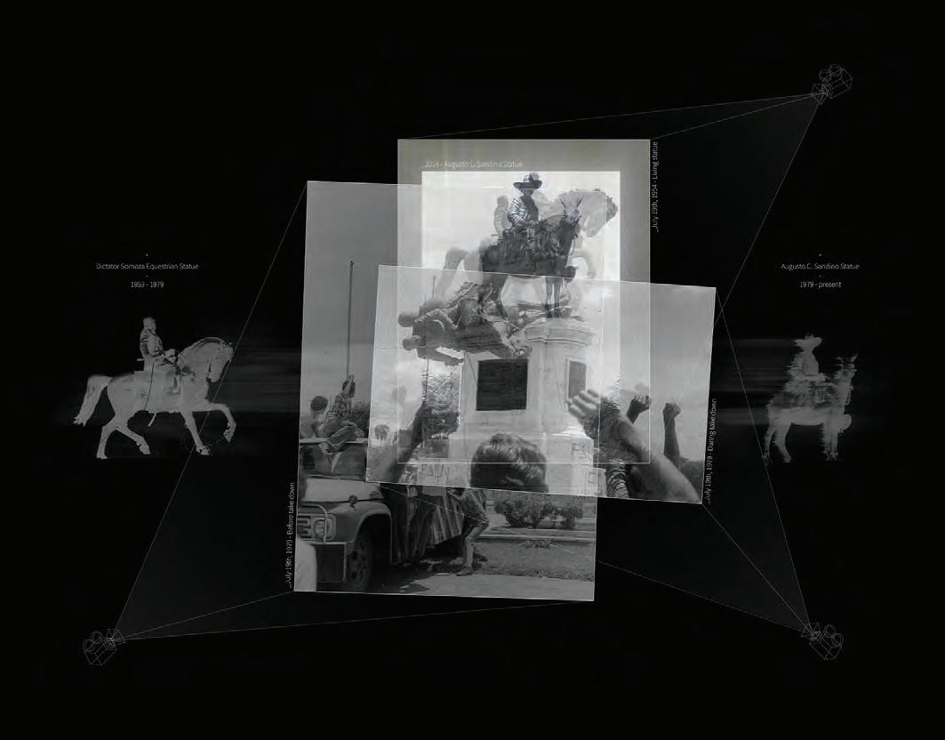
Political entanglements diagram with demolished monuments and mass production of political iconographic artifacts in Managua by the current regime. Author: Oscar M Caballero, 2021.
EXCERPTED FROM THE FORTHCOMING BOOK GHOST MONUMENTS, ANTICIPATED SUMMER
 2023
2023
GHOST MONUMENTS: An essay on resilience and urban memory in Nicaragua
Oscar m Caballero
Over the last 40 years, Nicaragua has been a country of no lasting resonance (Finney 2014). A nation trapped in a cycle of impermanence and urban deconstruction where innumerable monuments, buildings, and entire neighborhoods have been demolished by each new government to erase the memory of their predecessors (Cajina 2020). Daniel Ortega and Rosario Murillo, who have ruled the country under a political regime since their reelection in 2007, have increased the deconstruction frenzy of landmarks across the country and in particular, the capital, Managua (Mallonee 2014). Subsequently, their administration commissioned a mass production of political imagery with no patrimonial value to replace the demolished monuments. Nicaragua remains a dictatorship where the lack of free speech and manipulation of urban spaces has intensified the need to reminisce history without any political bias (Univision 2018). As a result, the regime’s attempt to eradicate urban memory to insert its own political doctrine has created a collective resistance to oblivion.
Author: Oscar M Caballero, 2021.

37 FLUIDITY AS (DE)CONSTRUCTION
DECONSTRUCTION FRENZY

Monuments function as symbols of history, resilience, and human achievement (Forest and Johnson 2011). In many countries, monuments with wrongful reflections of human history are taken down or recontextualized in the quest to redefine the politics of memory and oppression. However, Nicaraguan monuments are destroyed and reconstructed in a reversed process of history by design (Finney 2014).
Ghost monuments are both memories of the past, as well as vehicles for envisioning future possibilities. Intrinsically, ghost monuments are an antagonistic force against rendering the city as a unilateral space, calling denied accountability and authoritarianism into question.
Nicaraguan monuments have often played a historical role in empowering political activism and protest. For instance, on July 19, 1979, the equestrian statue of the dictator Anastasio Somoza was knocked down from its podium by members of the Revolución Sandinista (Quintero Diaz 2018). This event marked the restitution of a quasi-democracy over the 45-year-long Somoza Dynasty. As one cycle ended, another one started. In the decades to come the dictatorship’s monuments, urban spaces, and even street names were replaced by new ones alluding to the Sandinista party (Meiselas
1981 and Vannini 2014). However, as we have come to see in our history, the mere destruction of political monuments does not elude a future dictatorship (Vannini 2014). Instead, it creates a void in memory.
There are many ways to kill a monument. Often, the detachment between communities and their monuments is intentionally planned so that time can obscure their image. Likewise, environmental factors and other forms of neglect can quicken the decay of monuments, giving governments cause to demolish them (Cajina 2020). However, because regimes cannot always let time be their murder weapon, other actions are taken to accelerate the process of erasure.
Among the demolished monuments in Managua, we find La Concha Acústica, El faro de la Paz, and La Rotonda Plaza Inter along with murals, fountains, squares, and parks with relevant meaning to specific moments in Nicaraguan history (Acosta 2019). The volatility of the cityscape at such a scale impedes communities’ ability to connect with the new urban imagery due to the lack of permanence and social agency. Consequently, the cleansing of landmarks by the current regime only emphasizes the loss of spaces where collective memories had

38 OSCAR M CABALLERO
Floating ghost monument over transformed site of El Faro de La Paz. Author: Oscar M Caballero, 2022.
39 OSCAR M CABALLERO
Parallel monuments on same pedestal through history from Anastasio Somoza in 1954 to Augusto C. Sandino in 1979. Author: Oscar M Caballero, 2022.
been created. In this regard, the essence of the destroyed monuments prevails over their successors as a counter-memory that refuses to disappear. As the urgency to record history and memory increases, new technologies have also emerged to track Nicaragua’s constant changes. This process has allowed demolished landmarks to embrace immateriality, and become ghost monuments (Foresti 2022).

EL FARO DE LA PAZ (1990-2014)

“El Faro de La Paz” conveyed a powerful piece of Nicaragua’s history. It was designed by Architect Nelson Brown in 1990 and commissioned by the government of Violeta Barrios de Chamorro, the first woman president of Nicaragua. The lighthouse was located in Managua within the area most affected by the earthquake of 1972 and close to Lake Xolotlán. It commemorated the end of the civil war against the government of Daniel Ortega and the reinstitution of peace (Salinas 2014). The foundations of the lighthouse were cemented with fifteen thousand war rifles used in the civil war (Lara 2014). By burying these weapons, a new monument was created, not to make Nicaraguans forget the futility of violence, but to help them remember that peace can prevail after chaos.
Over time, the monument, and its surroundings were neglected from proper care and regulations for its use. The park that hosted the lighthouse was no longer just a recreational space and a celebration of history. It became part of a secluded area of the city where a lot of crime, clandestine businesses, and homelessness were very active through the years. The lack of interest and support from previous governments to preserve this monument contributed to its gradual decay, ultimately offering the current regime an opportunity for demolition (Ortega Ramírez 2014).
In 2014, the lighthouse was demolished by government order. According to the municipal council of Managua, it was a matter of public safety since it could collapse due to seismic activity. As with the previous destruction, no local authorities presented formal technical studies that could support this decision or verify if there was any danger at all (Salinas 2014). After its demolition, the park around the lighthouse was transformed into a recreational pool (Interview with Deputy Pedro Joaquin Chamorro 2014).
The outline of the pool traces the lighthouse’s original site, an echo of the past.
40 OSCAR M CABALLERO
Urban mapping of El Faro de La Paz site transformation from 2004 to 2022. Author: Oscar M Caballero, 2022.
ROTONDA PLAZA INTER (2003-2013)
The “Rotonda Plaza Inter” designed by Architect Glen Small was one of the first monuments to be destroyed in 2013. It was envisioned as a fountain centerpiece in a roundabout located in close proximity to the Hotel Plaza Inter (Vásquez 2013). Its location held a hightraffic orbit, turning it into an important urban node that inevitably became a popular point of reference in the city. In a country where the postal system does not hold a systemic order or function, landmarks are vital for traveling across the city and addressing locations. Often the name of these monuments merge with the roundabout; place and artifact are referred to as one.
The site of the monument was transformed into an altar to Hugo Chavez, a close socialist ally of Daniel Ortega and the former authoritarian leader who ruled Venezuela for almost 15 years. Intended as an homage to Chavez, the political device lacks gravitas. It is the pinnacle of a long-lasting charade for manufacturing new political idols for Nicaragua through alienated symbolism. Similarly, as General Augusto César Sandino was immortalized and turned into the symbol of the Sandinista party, a man turned into an ideal (Blandon 1960).
The composition of the altar carries a type of danger that is generational and resistant to time. The real impact of this type of political device happens when memory has been diluted, time has gone by without tools to remember, and reality has been fragmented from a collective
fact to distant unsupported tales. This generational amnesia takes away from communities the ability to seek change, creating a characteristic communist inability to disobey the political regime imposed.
LA CONCHA ACÚSTICA (2003-2014)

“La Concha Acústica” was an outdoor amphitheater in Managua, located at the shores of Lake Xolotlán, between Plaza Juan Pablo II and the National Theater Ruben Dario. This monument was commissioned under the right-wing administration of Mayor Herty Lewites in 2003, who became the closest contender against Ortega for the presidency until his sudden death before the elections
in 2006. The primary purpose of its construction was to create an urban space for public events relating to art, culture, and music. The architect for this project was Glen Small, who drew design inspiration from the nature silhouettes of the tropical landscape. With the view of Momotombo Volcano in the background, the curving monument resembled a flame emerging from the crater, moving along with the Xolotlán breeze (La Prensa 2014).
After the presidential reelection of Ortega in 2006, there was a rapid appropriation of the legacy built by the previous administration. “La Concha Acústica” became the selected space for Ortega’s presidential speeches and the celebration of events of the Sandinista party. The programmatic hijacking of the
Ghost Spectrum from Rotonda Plaza Inter overlayed on its successor monument, Rotonda Hugo Chavez. Author: Oscar M Caballero, 2022.
41 OSCAR M CABALLERO
amphitheater soon escalated, triggering vandalism. Several artifacts that reflected Ortega’s political iconography were placed, attached, and even inserted into the monument, causing numerous superficial damages and cracks on its concrete skin. Over time, the amphitheater was entangled in several layers of political propaganda in an attempt to appropriate its urban memory (Mallonee 2014).


In the end, the vandalism proved insufficient, and the regime ultimately sought the complete destruction of the monument. The demolition was carried out quickly with no apparent explanation in May 2014. When the process started, journalists spoke with Julio Maltez, an engineer employed by the Managua mayor’s office, who alleged that the structure was a matter of public danger since it could collapse at any moment, especially during a seismic event (Interview with Engineer Julio Maltez 2014). However, there were no official studies conducted to demonstrate the instability of the monument. In addition to the flawed rationale and unlawful actions for its destruction, the government also manipulated the country’s collective memory and fear of seismic destruction to further its political agenda. In fact, Sergio Obregón, the structural engineer of the monument, affirmed that the constant seismic activity in Nicaragua could not have caused significant damage to the amphitheater and the cracks on its concrete surface could have been repaired. It eventually took seven days for heavy machinery and a wrecking ball to demolish the monument; its resilient steel skeleton wouldn’t give in so easily (La Prensa 2014).
After the demolition of La Concha Acústica, the regime commissioned a new musical fountain that was soon demolished in August 2014 for a new tourist urban masterplan (Lara 2014). The original site of the amphitheater became an arid plaza slowly populated with political artifacts such as steel trees and propaganda.
42 OSCAR M CABALLERO
Forensic mapping of the demolition of La Concha Acústica and the monuments built after. Author: Oscar M Caballero, 2021.
PREVAIL
Ghost monuments inform us of a story beyond their lifetime, spanning their creation, deconstruction, and the monuments created to replace them. Over time, digital platforms created a safe arena for protesting against Ortega’s administration by immortalizing the memory of wrongfully demolished monuments. These digital spaces emulate the feeling of looking beyond the new monuments to view the past ones; as if their presence only serves to host the essence of their ghosts.

They offer an intangible approach to understanding urban memory and recontextualization through design. In this regard, it opens the threshold for imagining the future of current political monuments once a regime ends. Architecture has shown persistently how buildings can be repurposed and take on new typologies. Extending that premise, ghost monuments offer the possibility of recontextualizing or repurposing current political artifacts. Then, instead of continuing a cycle of destruction, communities can design the decay of the artifacts, reverting the scale of power by confronting hurtful memories with gestures of hope.
THE CHANCE TO REMEMBER THE PAST AND YEARN FOR THE FUTURE IS WHAT MAINTAINS THE ENDURANCE OF COMMUNITIES THAT ARE LIVING UNDER OPPRESSIVE SYSTEMS. THE DIGITAL MEMORY OF GHOST MONUMENTS HAS CREATED A SAFE MEDIUM FOR MEMORY HOLDING, AS A SILENT REMINDER HIDDEN IN PLAIN SIGHT FOR THOSE WHO RESIST ERASURE.
----- “A fragment of this research was originally published as NICARAGUAN GHOST MONUMENTS: POSTHUMOUS MEMORIES OF “LA CONCHA ACÚSTICA” on May 9th of 2022 on Monument Lab. [https://monumentlab.com/bulletin/nicaraguan-ghost-monuments-posthumous-memories-of-laconchaacustica].”
----- This research was further discussed on an episode of Ecos Patrimoniales Podcast, a platform for critical discussion on culture, memory, and monuments. Episode link: https://open.spotify.com/ episode/2b4Ak6oZOxBkrAKKM7oHdf?si=5f0a43b0622b4dc0
43 OSCAR M CABALLERO
Approaching one year without East River Park
Emily sandstorm

SCENES OF DEBRIS, DIRT, AND MISCELLANEOUS CONSTRUCTION TOOLS NOW FILL THE SOUTHERN HALF OF EAST RIVER PARK, LOWER MANHATTAN, WHERE THERE WAS ONCE WILDLIFE, AN ABUNDANCE OF TREES, AND A VIBRANT 57-ACRE STRETCH OF GREENLAND. THE WATERFRONT PARK IS A BELOVED AND HISTORIC HOME TO LOCAL EAST VILLAGE AND LOWER EAST SIDE RESIDENTS, AS WELL AS UNDERSERVED COMMUNITIES IN THE CLUSTERS OF PUBLIC HOUSING BUILDINGS THAT SIT DIRECTLY OPPOSITE.
Demolition went ahead after a tense sequence of events, in which the city scrapped its community-backed plan for a more expensive and environmentally compromising redesign on a whim. As we approach the one-year mark of construction beginning on East River Park, it is a poignant time to reflect on the impact that was made on the local community, and what the fractured trust between residents and officials about environmental protections in New York City now looks like moving forward.
The aftermath of Hurricane Sandy left Lower Manhattan swamped, flooding the FDR drive and nearby buildings with waves as high as 14 feet. It shut Wall Street for numerous days and left nearby residents without electricity for more than two weeks. The need for local climate mitigation became increasingly apparent. The Federal government along with the Department of Housing and Urban Development announced a competition called “Rebuild by Design,” for a coastal infrastructure plan. An initial project named the “Big U” by BIG and ONE Architecture was selected for the first phase of the city’s approach to protecting Lower Manhattan, involving a comprehensive system of walls and landscaping. The Department of Design and Construction (DDC) narrowed down the plan to a smaller impact area, to what eventually became the East Side Coastal Resiliency project (ESCR). It was continuously commended for exercising a meaningful public engagement process. Invested local residents met with lead architects on the project from One Architecture & the Bjarke Ingles group, for what was described as an iterative and measured approach to how floodwall protection could be provided, without compromising the legacy and value that the park held in its community (Kimmelman 2021).
The model exercise in participatory design was immediately thwarted when Mayor de Blasio’s administration scrapped the proposal in 2018, claiming there was a new plan that was justified as being more technically sound, and would evade the issue of losing time to use federal funds on the project.
44 FLUIDITY AS (DE)CONSTRUCTION
The new plan was distinctly different: It would bury the original park under eight feet of landfill, elevating the new park by eight feet on top of the large surge barrier. It would cost the city nearly twice as much as the original plan, with an estimated completion date of 2026. The ESCR plan claims to protect the area from storm surges until only 2050, when it is said that the park may need to be raised again (NYC Gov East Side Coastal Resiliency Project n.d.).
The sudden decision for the new design pulled the rug out from under the many local stakeholders who had invested time and thoughtful participation into how their community would best be protected. Trust was immediately fractured and garnered local pushback, including the formation of East River Park Action group. The non-profit group hosts meetings, has organized protests, and opened dialogue about the ecological damage that would be caused by the park's proposed elevation. Members of the group have repeatedly stated that climate protection is an imperative, and whilst they have no interest in feeling like obstructionists, the manner in which the city went about the planning was simply more expensive, more destructive and less effective (Plenge 2022).
In conversation with one of the organizers of ERPA, John Plenge, it was apparent that the community experienced a tremendous sense of loss and grief in losing the park. For the group, the consequences of ecological damage continue to remain at the forefront of their concerns. The numbers speak for themselves: it is estimated that when the ESCR project is complete, 991 mature trees will have been removed (Smithson 2022). This is a significant loss to the astounding biodiversity and wildlife that once proliferated the space. The city promises to plant 1,800 immature trees as part of the renovation, which still spawns a number of important concerns. Chiefly, decades will elapse without adequate shading. It would take more than 30 years (in good conditions) for saplings planted to reach a height where they could provide any shade, dismissing one of New York City’s most pressing concerns related to climate change, which are the effects of heat surges. The promise of planting double the amount of trees that once existed in the area will still not provide benefits to the excavated area in an adequate amount of time. In addition to this, the air filtration and carbon sequestering capabilities of a sapling are nowhere near that of a mature tree, creating an extended chain of environmental concerns. With the demolition underway, the park is now made up of vast amounts of unshaded areas, including an outdoor gym and recreation facilities.
This begs the question of how New York City, a world city with access to arguably some of the best climate engineers, planners, and resources, attempted to solve one issue of the looming climate crisis by exacerbating another. Plenge, who has been using the waterfront park for almost 30 years states that the administration was shortsighted in its approach, martyring a rare rural space in an increasingly artificial city. He makes the striking point that as new environmental challenges emerge,
FLUIDITY AS (DE)CONSTRUCTION 45
THE CITY NEEDS TO ENTIRELY RETHINK ITS APPROACH TO THE CONVERSATION OF NATURE, AND OVERALL, ITS APPROACH TO THE CLIMATE CRISIS.
DRAWINGS AS CONSTRUCTION SITES KADEN BEILMAN
DRAWING IS CONSTRUCTING, IS DRAWING TO DRAW IS TO CONSTRUCT. IT’S FAR FROM A NEW IDEA IN THE CONTEXT OF SPATIAL DESIGN; AND ARGUABLY, IT’S BEEN THE IDEA FROM THE START. DRAWING IS A MEANS TO COMMUNICATE SPATIAL RELATIONSHIPS, AND, HAD THERE BEEN NO REASON TO COMMUNICATE AN OVERHEAD PLANE, THE DASHED LINE WOULD NOT HAVE A PLACE IN THE ARCHITECT’S REPRESENTATIVE TOOLKIT.
If not for the economy of alignment, construction lines would be a nuisance. The relationship between spatiality and drawing is so symbiotic, it’s difficult to tell which causes the other. With a leap of the imagination, through the hoop of abstraction, we can understand the blank paper as the site of construction.

On the construction site, time is money, and so is accuracy. Misplacing elements, working with inaccurate measurements, and mismanaging work is costly—likely to lead to the failure of a project. The exact opposite is true of drawing. The site at which we construct drawings has no relationship to (the) economy, cost free, besides the micrometers of graphite shaved down by the teeth of the paper. Lines escape from the pencil misaligned with their intended place on the paper. Fortunately, it is inconsequential. Mistakes in drawing are data that propel a design, sketch, or thought closer to its desired form. The lines are improvisational—they configure, dismantle, reconfigure, over the course of seconds.
Drawing rewards fluidity. Construction rejects it. The human holding the pencil, surveying the space must know this. Fluidity in drawing means room for misinterpretation. There is space with fluctuation, there is forgiveness in correction, there is time for adaptation.
46 FLUIDITY AS (DE)CONSTRUCTION


“everything changes; everything is connected; pay attention.”
47 FLUIDITY AS (DE)CONSTRUCTION
- Jane Hirschfield

48 KADEN BEILMAN

49 KADEN BEILMAN 49

50 KADEN BEILMAN
Embracing drawing for its fluidity is more than a cop-out for an imperfect drawing—it’s a celebration of the human spirit, the hand’s ability to draw what the mind cannot see.
Embracing drawing for its fluidity is more than a cop-out for an imperfect drawing— it’s a celebration of the human spirit, the hand’s ability to draw what themind cannot see.
51 KADEN BEILMAN

THE ARTISTIC CRUSADE TO REMEDIATE OUR WATERBODIES
Ecological Restoration as Eco-Art: NATALIE BARTFAY
N.B.: This piece is about ecological art, an artistic practice born from the environmental and land art movements that emphasizes environmental action and ecology.


Waterbodies—an area of land in which all water drains into a particular basin and the living environment within it—are one of the largest reservoirs of human-created pollution and some of the most pollutionsensitive ecosystems. Thus, since the first days of the eco art movement, many ecoartists have used waterbodies as their medium. Whether focusing on specific bodies of water or an entire watershed, artistic thought has a powerful effect on the remediation of water and watersheds.
These aquatic systems are often public spaces and lend themselves to sites for public art.
Eco-artists work to make both deeply personal and physical impacts with their installations. In response to water and wetland degradation, these artists work outside of traditional means to create a relationship between the viewer and the outside world. These artists see aspects of the planet as their workspace and their work: to restore it. The park landscapes, however, take on a much larger role than just the canvas; when these installations are installed in a landscape, the project extends to the affected environment; the art is the relationship between the work
of the artist and the land itself.
While much eco art is created purely to give the viewer a greater environmental perspective, art installed within a community’s natural water systems is unique because its features demand to be part of the ecosystem. It is not a monument to but an extension of the system itself, and functions in communion with it. The essential aspect of an aquatic installation is that it works with the greater environment, aiding in the restoration of a degraded area.
Art that integrates into an ecosystem is significant because it takes a long-term role and stake in the system. It is not only an installation but a tool for intervention that will change what surrounds it, likely for the better. Therefore, art comes in the form of infrastructure, and this infrastructure is art; public infrastructure, especially public parks, is increasingly accepted as an important artistic medium. Karl Ganser, a German geographer and proponent of urban ecological regeneration, wrote, “the future quality of infrastructure will be the landscape… Not just any landscape, but an ecologically intact and aesthetically satisfying one.”
Figure 2. The Harrisons, Presentation of Lagoon Cycle, 1973-1985.
54 FLUIDITY AS TRANSFORMATION
THE HARRISONS AND THE BIRTH OF WATER-BASED ECO-ART
Water bodies and water-use art came out of the traditions of conceptual and maintenance art. Artists like Mierle Laderman Ukeles promoted the idea that ordinary, useful action was an artistic statement in itself (Weintraub 2012). While Ukeles focused on the human body and its functions within its typical environments, ecological artists like the Harrisons negotiated what infrastructure could do within the environment at large. Helena and Newton Harrison rose to prominence in the early 1970s with their use of nature’s natural functions like growth, evolution, and decay integrated into their art. Regarded as innovators within the field of bio art, they helped to establish watersheds as the main canvas of “eco art explorations” and its solution-based mission (Weintraub 2012). In many ways, this work was in response to what they observed as a general disregard for nature in most installation art; with their art, they sought to not only expand artistic perspectives but also make a tangible impact.
The Harrisons’ first major project involving the greater environment was Lagoon Cycle (Figure X). Developed between 1973 and 1985, Lagoon Cycle is a narrative that grew to address the entire Pacific Coast ecosystem and the systemic issues it faced. The Harrisons use photographs, drawings, and maps to communicate their work and include explanations of possible solutions (Kastner 1998). The narrative they formed around their remediation process is part of their artistic statement, with the most important piece of that being the real restoration at hand.
While working on various eco-art projects within the Pasadena area, the Harrisons were inspired to begin to heal the Earth’s wounds. In 1984, the Harrisons were taken to the lower Arroyo River, which was then little more than a concrete-lined channel, and noticed
how this unnatural intrusion was to the ecosystem’s floodplain (Heartney 1995). This wound inspired the Harrisons to create Arroyo Seco Release/ A Serpentine for Pasadena (figure X) the following year. To address the damming and abnormal flooding patterns around the Arroyo River, the Harrisons proposed enclosing and capping the channel and laying topsoil over it to create a natural and unobtrusive streambed atop it. Flooding season would allow the stream to recharge from the channel overflow and this would restore the ecosystem’s processes. Always keen on dramatic language, he Harrisons said of their proposal “Let a grand restitution take place/ Let the process of flood control/ Be separated from the destructions of rivers” (Heartney 1995). While their serpentine was never installed on the Arroyo River, the infrastructure was quickly adapted at Devil’s Gate in Pasadena, with residents of the area celebrating the work.
The Harrisons continued with similar projects and remain active proponents of the field. Their actions reverberated throughout the environmental art community. While many critics argued that their work “belongs more properly within the realm of science than art,” the Harrisons encouraged metaphoric thinking with their action on both an environmental and human level (Heartney 1995). Their work is unorthodox in nearly every way and effective social commentary on what some would call mere technology.
ART ’WORKS:’ KEY ARTISTS AND PROJECTS
Public water and watershed remediation is an effective venue for eco art because it affects the entire community of plants, animals, and human beings. Remediation efforts reflect the needs of that community, with the art being utilized in various manners. Art can lead to the betterment of an aquatic environment in three main ways: fostering water management, like water
detention or flood protection; fostering stronger aquatic habitats; or, aiding in water quality regeneration, through pollution control,filtration, or by some other means. The integration of different utilities for water systems has been experimented with by artists in distinctive ways.

Herbert Bayer was one of the first artists to expand the “scope of public art far beyond monumental personal expression” (Wientraub 2012). Bayer was a Bauhaus-trained Austrian who was integral in the combination of engineering and art, and his work was lauded at the seminal conference Earthworks: Land Reclamation as Sculpture. He was one of the few artists included whose designs went beyond aesthetics; Bayer made a deliberate choice to have art that ‘worked.’ His most influential work was Mill Creek Canyon Earthworks (figure 5), originally completed in
1982. This project creates a canyon water management system in Kent, Washington. Here, a floodplain drained down into the downtown and caused damaging floods every winter. While traditional infrastructure was proposed for the area, the mayor complained that its bulky nature restricted public access (Wientraub 2012). Bayer proposed a
Figure 1. Betsy Damon, Living Water Garden. 1998, Chegdu, China.
55 FLUIDITY AS TRANSFORMATION
water detention system created out of earthen and concrete ridges and circular forms, which created pools for water and pathways to help visitors enjoy the park and have a “refined aesthetic experience” (Kastner 1998). Essentially, Bayer created a beautiful and natural dam that became a part of the landscape. This water detention project created an integral and enjoyable park for Kent and successfully integrated fine art into an ordinary operation.
by the Dallas Museum of Natural History to revitalize a lagoon that suffocated under eutrophication, caused by algal blooms spawned by fertilizer runoff. At this site, she created a park called Fair Park Lagoon (figure 6). She began this piece by clearing the blooms and cleaning the water, then installed two expansive sculptures, each designed to look like a native plant of the area. These sculptures had spaces at their bases, that is, the roots, where wildlife habitats were created. The vegetation planted was such that it supported the animals in this habitat, helping to stabilize and regenerate the environmental health of the landscape (Kastner 1998). Finally, pathways for people were created around the park so it could be easily enjoyed. Johanson was able to restore an aquatic habitat, which improved the aesthetics and biological diversity of a park, a process that she would repeat at many other sites around the world.
NEW YORK CITY PUBLIC SPACE
Our home, New York City, is a very particular site for water eco art because it is home to very high rates of water system degradation; the city has two aquatic superfund sites and the rivers and bays are widely regarded as heavily polluted, no thanks to the disregard for pollution runoff from industrial sites. This is all in the face of looming sea-level rise, which will be incredibly detrimental to the geography of New York. While ordinary denizens of the city tend to be dispassionate about its environment, artists are inspired to address these problems.
Patricia Johanson was another prominent artist and park designer during this time and, like the Harrisons, was a leading pioneer in ecological revitalization within public spaces. As Johanson developed as an artist, she began to integrate biological restoration into her work. She aimed to create functional infrastructure as art, saying, “the real reason I only design parks and fountains these days is that I’m sick of the whole museum/collector/auction house complex with the self-congratulatory prattle about how much they’re doing for culture” (Kastner 1998). Johanson realized that her work as an artist could have an appreciable effect on people’s lives by improving the environment of the community. In the 1980s, Johanson was commissioned

Betsy Damon is one of the leading artists who seek to clean up rivers. For decades, Damon and her group, Keepers of the Water, have strived to create spaces that improve the health of polluted waterways while engaging the public (Damon 2011). Damon’s most influential work is Living Waters Garden in Chengdu, China (figure 7). This park was developed along the bank of the river that runs through the city of Chengdu. Damon created a natural, seven-stage water filtration system modeled after both nature and advanced water treatment processes. Shaped like a giant fish, the system included a settling pond, wetland environments with microbes and plants, and three filtration ponds to purify the river, and also functions as a running water installation in the riverside park. Damon was later contracted by the city for other projects, helping the city become one of the greenest in China by the 2000s (Damon 2011).
As eco art and technology have evolved, artists have begun to utilize art in even more specific ways, creating infrastructure that has multiple ecological applications. New York City is a great breeding ground for this art as it is a major nexus point of artists, need and capital for infrastructure, and ecological degradation. One project in particular, which has been highlighted by the Landscape Architecture Foundation, is Dutch Kills Park in Long Island City, Queens (figure 7). The city of New York and artist Michael Singer teamed up to revitalize space alongside one of the busiest roads in New York to create one of the most innovative plazas in Queens. The park created a half acre of wetland in the middle of the city, which helps to combat the negative environmental effects of urbanization. Singer designed 3000 sculptural pavers for the park (figure 8) which create patterns and textures that aid in the absorption of 20.2 million gallons of stormwater a year in the area (Dutch Kills Green 2017). The pavers are permeable and help to direct stormwater into infiltration areas. This innovative park beautifies the neighborhood and works as a steward of the watershed.
56
Figure 5. Herbert Bayer, Mill Creek Canyon Earthworks, 1982.
infrastructure. NATALIE BARTFAY
Eco art is public art and infrastructure.

BATTERY PARK
Similar artists have begun thinking about the future. New York City is predicted to lose lots of land mass from sea level rise due to global warming. Designers have begun proposing innovative designs to the city about how they could combat this issue, following in the footsteps of the eco artists before them.

Mixing wetlands with traditional park space would restore the natural dynamics of the island and be a beautiful infrastructure project that would only add to the look of the Financial District. Other proposals, like the architecture firm Scape’s Oyster-tecture, are reminiscent of the work of Johanson. Oyster-tecture proposes the installation of oyster reefs in the Gowanus Canal to manage pollution and create a healthier aquatic habitat in addition to absorbing sea level rise.


These works showcase the natural dual roles of infrastructure as art and aid and have popularized the idea that infrastructural innovation can be beautiful.
Public space has always been one of the most efficient sites for eco art because it gives art that ‘works’ the largest impact, and ecological projects that have remediated and regenerated aquatic and coastal environments tend to be especially effective. Public art in parks is so special because it creates a space for communion; the eco artists who have recognized this have been some of the most impactful on human thought while reducing human impact itself on the Earth.
NATALIE BARTFAY
Figure 6 (below) Patricia Johanson, Fair Park Lagoon, 1986.
Figure 3 (left) The Harrisons, Presentation of Lagoon Cycle, 1973-1985.
Figure 7 (above) Betsy Damon, Living Waters Garden, 1998.
Figure 4 (top 1) The Harrisons, “Pasadena Part 1,” Arroyo Seco Release/ A Serpentine for Pasadena, 1985.
57
EDITED/COMPILED BY NATALIE BARTFAY
Envisioning Community-Led Climate Adaptation & Housing Mobility in San Juan, Puerto Rico

2022 Summer Workshop, Columbia GSAPP

In May and June of 2022, twelve Columbia GSAPP students traveled to Puerto Rico for the summer workshop "Envisioning Community Led Climate Adaptation and Housing Mobility in San Juan, Puerto Rico."
With this workshop, we sought to examine land management strategies in flood-prone communities with histories of spatial exclusion and colonial oppression. Our questions and motivations included understanding best practices for community engagement and pushback from communities, among others. This work complemented a recently completed urban planning studio on frontline climate adaptation approaches in New York City, co-taught by Professor Sarmiento to many of the workshop’s participants. Our experiences provided a comparative example of climate adaptation—specifically, managed retreat and housing relocation—to New York City’s buyout program.
58
FLUIDITY AS TRANSFORMATION
HOW
CAN
LAND MANAGEMENT STRATEGIES
SUCH AS COMMUNITY LAND TRUSTS SUPPORT CLIMATE ADAPTATION AND HOUSING MOBILITY IN FLOOD-PRONE COMMUNITIES WITH HISTORIES OF SPATIAL EXCLUSION AND COLONIAL OPPRESSION?


Puerto Rican sites contrasted with the local work in New York City. In particular, housing relocation in San Juan demonstrated an alternative practice that claims to forward institutional community participation instead of just state, federal, and municipal actors.
This work also supported a broader goal: to build collaborative relationships between New York and Puerto Rico’s frontline community leaders and climate planning professionals. Moving forward, we hope Columbia GSAPP's graduate urban planning program will continue to share insightful comparative analyses beyond the confines of academia in ways that frontline communities and climate planners would find useful.
Casa Pueblo in Adjuntas, where we learned more about their community and renewable energy efforts, including their ‘solar forest.’
Caño de Martín Peña, a channel in San Juan with frequent flooding and sanitation issues. Informal flooding barriers line the banks, as seen here.
WORKSHOP ABSTRACT
59 FLUIDITY AS TRANSFORMATION
Our workshop spanned site visits across government agencies, quasi-government groups, nonprofits, think tanks, academia, and community organizations. During each visit, we presented our findings from the New York City urban planning studio and shared questions and insights on our respective projects.
CONTEXT ACADEMIA
Maritza Barreto-Orta, Director of the Puerto Rico Coastal Planning and Research Institute, pictured with Prof. Sarmiento, Assistant Professor at Columbia GSAPP, at the University of Puerto Rico.

GOVERNMENT
FEMA’s Central Office for Recovery, Reconstruction, and Resiliency (COR 3), where we shared our research and heard from Executive Director Manuel Rivera.
POLICY

Center for a New Economy (CRE), Puerto Rico’s leading think tank, where we spoke with Raúl Santiago-Bartolomei about his reserach on issues of sustainability and urban change.

60 2022 PUERTO RICO SUMMER WORKSHOP
CANO MARTÍN PENA
Our primary study site was the communities around El Caño Martín Peña, a 3.75-milelong tidal channel located in the center of San Juan. Formerly a mangrove forest, the wetlands were developed by new city dwellers in the twentieth century. Informal settlement processes have left most areas without sewerage, and wastewater and other pollutants discharge into El Caño. Due to this practice, the channel overflows during periods of rain, endangering 26,000 residents with flooding, water-borne health risks, and harm to biodiversity.
Proyecto ENLACE
Corporación del Proyecto ENLACE del Caño Martín Peña is a local development corporation that organizes and aligns environmental initiatives by the G-8 and municipal and private actors for the overall well-being of the community and restoration of the channel. Local participation and collective action work to promote new avenues of community and economic development.
G-8
The G-8, Grupo de las Ocho Comunidades

Aledañas al Caño Martín Peña, is an association of the eight communities in the channel’s special planning district. This body of community leaders is a forum for resident decision-making. A non-profit organization, they oversee Fideicomiso, the local open space and affordable housing land trust, and ENLACE, designed as a short-term corporate instrument.
Marvel Designs
Marvel Designs is an interdisciplinary design studio with offices in New York City and San Juan. They have worked collaboratively with ENLACE to plan and design ten public spaces throughout the eight communities. These scattered sites create an interconnection and respond to community needs.
José, a canalside resident, describes his changing neighborhood and planned move from his home.

61 2022 PUERTO RICO SUMMER WORKSHOP
Speaking with a G-8 leader at her home in near el Caño.
QUESTIONS
What are existing best practices when it comes to community engagement in post-disaster housing relocation?


Where have assumptions about neighborhoods not been correct?
What are interventions that have succeeded in land management? Where has there been the most pushback from communities?
 Marvel’s work on housing in San Juan.
The municipal plan for the Caño Martín Peña special district. Buildings in red represent new housing managed under the community land trust. Plan courtesy of Proyecto ENLACE.
Marvel’s work on housing in San Juan.
The municipal plan for the Caño Martín Peña special district. Buildings in red represent new housing managed under the community land trust. Plan courtesy of Proyecto ENLACE.
62 2022 PUERTO RICO SUMMER WORKSHOP
Former organizers with ENLACE speak on the challenges and opportunities the organization has faced.
OBSERVATIONS & FINDINGS
Our findings suggest that climate adaptation is more comprehensively planned in Puerto Rico than in New York City; this is enabled by rigorous work by both municipal agencies and community leaders organizing against city-led efforts. But, this seemingly rigorous planning is also a site of conflict, particularly given the legacy and ongoing histories of colonialism.
Colonialism from the mainland United States exacerbates the risk of climate change, like “natural” disasters, hurricanes, and blackouts— forcing individuals to rely on extractive energy practices like FEMA’s control of the electricity grid or COR3’s distribution of disaster relief funds. We could not go anywhere in Puerto Rico without hearing megastar Bad Bunny’s “El Apagón” (English: “The Blackout”), a new song that has garnered millions of streams and music video
views globally, prompting people to reflect on the historical and present-day colonization in Puerto Rico regarding issues including, but not limited to, gentrification, displacement, and coastal privatization empowering Boricuas to resist. With recent protests across the Puerto Rican diaspora—from New York to San Juan—calling for decolonization and rallies against LUMA, the new Puerto Rican power authority, extractive tourism, and other symbols of American institutions, we must think comprehensively about the structural factors that are not always foregrounded in the planning process.
Other highlights include meeting Dr. Ivis Garcia and her graduate students in urban planning from the University of Utah, touring the neighborhoods around El Caño de Martín Peña, and salsa dancing with Professor Sarmiento!
INSTRUCTOR: HUGO SARMIENTO WORKSHOP TEAM: EMMA SUMROW, ESHTI SOOKRAM, DMITRI JOHNSON, KYLIEL THOMPSON, MATTHEW SHORE, MOLLYE LIU, NATALIE BARTFAY, NIKOLAS MICHAEL, ROB SANCHEZ, SABINA SETHI UNNI, AND SEAN CHEW

63 2022 PUERTO RICO SUMMER WORKSHOP
, Notes on Fluidity
Letter from the Editors by Fall 2022 Editing Staff
Original image (before rendering): Orlova, Maria. Unnamed. Photograph. Mario Orlova. n.d. https://www. orlovamaria.com/people.
Bound by Tragedy: a Reflection on Flooding in NYC
by Shivani Persaud
Edited by Felipe
Urrutia
Persaud, Shivani. Unnamed. Photographs. n.d
Fluidity in Architecture by Ashley Colas
Edited by Alyana Acacio
Colas, Ashley. Unnamed. Digital renderings. N.d
Can a Cypriot Salt Marsh Tell Us the Future of Climate Change?
by Nikolas Michael
Edited by Matthew Meyer
Hazell, Calian J.; Pound, Matthew J. and Hocking, Emma P. 2022. Response of the Akrotiri Marsh, island of Cyprus, to Bronze Age climate change, Palaeogeography, Palaeoclimatology, Palaeoecology. Volume 587, 110788, ISSN 0031-0182, https://doi.org/10.1016/j.palaeo.2021.110788.
Michael, Nikolas. Unnamed. Photographs. n.d
Water in Alexandria by Calvin Harrison
Edited by Gabby Coleman
Harrison, Calvin. Unnamed. Photographs. n.d
Gender Inequality in the Context of India: Using Public Toilets as an Example by Shuyang Huang
Edited by Felipe Urrutia
Ali, Amir. 2001. “Evolution of Public Sphere in India.” Economic and Political Weekly 36 (26): 2419–25.
Anthony, Kathryn H., and Meghan Dufresne. 2007. “Potty Parity in Perspective: Gender and Family Issues in Planning and Designing Public Restrooms.” Journal of Planning Literature 21 (3): 267–94.
Chakrabarty, Dipesh. 1992. “Of Garbage, Modernity and the Citizen’s Gaze.” Economic and Political Weekly, 541–47.
Doron, Assa, and Ira Raja. 2015. “The Cultural Politics of Shit: Class, Gender and Public Space in India.” Postcolonial Studies 18 (2): 189–207. https://doi.org/10.1080/13688790.2015.1065714.
Douglas, Mary, and M. Kalender. 1956. “Purity and Danger.” THE DEVIL’S CHAIN, 284.
Edensor, Tim. 1998. “The Culture of the Indian Street.” Images of the Street: Planning, Identity and Control in Public Space, 205–21.
Gupta, Aashish, Diane Coffey, and Dean Spears. 2016. “Purity, Pollution, and Untouchability: Challenges Affecting the Adoption, Use, and Sustainability of Sanitation Programmes in Rural India.” Sustainable Sanitation for All: Experiences, Challenges, and Innovations 283.
Jayawardena, Kumari. 2016. Feminism and Nationalism in the Third World. Verso Books.
“No Public Toilet for Women in Delhi – ActionAid India Survey Highlights Concerns That Women Encounter in Accessing Public Toilets in the Capital | ActionAid India.” n.d. Accessed December 17, 2021. https:// www.actionaidindia.org/press-release/no-public-toilet-for-women-in-delhiactionaid-india-survey-highlights-concerns-that-women-encounter-inaccessing-public-toilets-in-the-capital/.
Phadke, Shilpa, Sameera Khan, and Shilpa Ranade. 2011. Why Loiter?: Women and Risk on Mumbai Streets. Penguin Books India. Phadke, Shilpa, Shilpa Ranade, and Sameera Khan. 2013.
“Invisible Women.” Index on Censorship 42 (3): 40–45. https://doi. org/10.1177/0306422013500738.
Ramani, Shyama V. “Why It’s Easier for India to Get to Mars than to Tackle Its Toilet Challenge.” The Conversation. N.d. Accessed December 17, 2021. http://theconversation.com/why-its-easier-for-india-to-get-to-mars-than-totackle-its-toilet-challenge-69015.
Royan, Jorge. Public toilets in the city of Varanasi in India. Photograph. n.d. https://theconversation.com/why-its-easier-for-india-to-get-to-mars-than-totackle-its-toilet-challenge-69015
Sulabh International Social Service Organization. “Sulabh Public Toilets & Bath Complexes.” n.d. https://www.ircwash.org/sites/default/files/822IN96-14708.pdf.
Sulabh International. Plan for the public toilet in Hajiali Circle, Mumbai. Photograph. n.d. https://www.ircwash.org/sites/default/files/822-IN96-14708. pdf
Silent Affirmation Painting by Osaze Stigler
Edited by Ethan Floyd
Stigler, Osaze. Unnamed. Painting. n.d
“for the planners who did the best they could” by Geryel Osorio Godoy

Edited by Kyliel Thompson
Original image (before rendering): Simumpande, Diana. Colours of the Wind. Photograph. Diana Simumpande. 2017. https://unsplash.com/photos/xZgkFQ4Hijc
CITE
64
GHOST MONUMENTS: An Essay on Resilience and Urban Memory in Nicaragua by
Oscar Caballero
Edited by Olivia Jia
Acosta, Raquel. “6 Monumentos históricos destruidos o modificados por la dictadura orteguista”. La Prensa, July 13, 2019. https://www.laprensani.com/2019/07/13/suplemento/la-prensadomingo/2568890-6-monumentos-historicos-destruidos-o-modificadospor-la-dictadura-orteguista
Blandon, Jesús Miguel. Entre Sandino Y Fonseca Amador. Spain: Ed. Nunca Mas, 1960.
Caballero, Oscar M. Political entanglements diagram with demolished monuments and mass production of political iconographic artifacts in Managua by the current regime. Digital renderings. 2021.
Caballero, Oscar M. Parallel monuments on same pedestal through history from Anastasio Somoza in 1954 to Augusto C. Sandino in 1979. Digital renderings. 2022.
Caballero, Oscar M. Urban mapping of El Faro de La Paz site transformation from 2004 to 2022. Digital renderings. 2022.
Caballero, Oscar M. Floating ghost monument over transformed site of El Faro de La Paz. Digital renderings. 2022.
Caballero, Oscar M. Ghost Spectrum from Rotonda Plaza Inter overlayed on its successor monument, Rotonda Hugo Chavez. Digital renderings. 2022.
Caballero, Oscar M. Mapping of vandalism to La Concha Acústica with political artifacts and propaganda. Digital renderings. 2022.
Caballero, Oscar M. Forensic mapping of the demolition of La Concha Acústica and the monuments built after. Digital renderings. 2021.
Caballero, Oscar M. Ghost spectrum projection of La Concha Acústica through memory devices. Digital renderings. 2021.
Cajina, Indiana. “Nicaragua sin memoria histórica: El vicioso círculo de construcción y demolición de monumentos”. Nicaragua Investiga, July 31, 2020.
https://nicaraguainvestiga.com/nacion/23442-nicaragua-sinmemoria-historica-el-vicioso-circulo-de-construccion-y-demolicion-demonumentos/
“Concha Acústica cede a la demolición en el Malecón de Managua,” El Nuevo Diario, last modified May 05, 2014. Interview with Engineer Julio Maltez.
Finney, Annelise. “The cycle of impermanence: collective memory and politics of monuments in Managua, Nicaragua” (Undergraduate Thesis, Barnard College, 2014), para. 1-2.
Forest, Benjamin and Juliet Johnson (2011) Monumental Politics: Regime Type and Public Memory in Post-Communist States, Post-Soviet Affairs, 27:3, 270.
Foresti, Claudia. “In Milan, the first monument in the world in the Metaverse”. Interni Magazine, Jan 05, 2022.
https://www.internimagazine.com/agenda/in-milan-the-first-monument-in-theworld-in-the-metaverse/
La Prensa. “ Alcaldía se lleva metal de la Concha Acústica”. May 10, 2014. Print
La Prensa. “La Concha Acústica”. Last modified May 11, 2014. https://www. laprensani.com/2014/05/11/seccion-domingo/193943-la-concha-acustica
Lara, Rafael. “Faro de la Paz, otro monumento demolido en la capital”. El Nuevo Diario, May 05, 2014.
Lara, Rafael. “Tiran fuente para abrir paso al paseo Xolotlán”. El Nuevo Diario, last modified August 14, 2014.
Mallonee, Laura. “Psychedelic Symbols of State Power in Nicaragua.” Hyperallergic, March 31, 2014.
https://hyperallergic.com/117612/psychedelic-symbols-of-state-power-innicaragua/
Mallonee, Laura. “The Politics of Architecture in Nicaragua.” Hyperallergic, May 18, 2014. https://hyperallergic.com/128686/the-politics-of-architecture-in-nicaragua/
Meiselas, Susan. Nicaragua: June 1978-July 1979 (New York: Pantheon Books, 1981) 45, 71.
Ortega Ramírez, Pedro. “Faro de Parque de la Paz es destruido por representar peligro”. El 19 Digital. Last modified May 05, 2014.
Quintero Diaz, Daniela. “El día que cayó Anastasio Somoza, el último dictador de Nicaragua.” El Espectador. July 18, 2018. https://www.elespectador.com/ mundo/america/el-dia-que-cayo-anastasio-somoza-el-ultimo-dictador-denicaragua-article-800962/
“Reacciones ante demolición de faro de la paz,” La Prensa, last modified May 06, 2014. Interview with Deputy Pedro Joaquin Chamorro. https://www. youtube.com/watch?v=J1jznHKUJRU
Salinas, Carlos. “Nicaragua demuele su pasado”. Internacional, May 15, 2014.
Univision. “En fotos: Una semana de protestas, represión y muerte en Nicaragua”. Last modified April 19th, 2018. https://www.univision.com/noticias/america-latina/en-fotos-una-semana-deprotestas-represion-y-muerte-en-nicaragua-fotos
Vannini, Margarita. “Políticas públicas de la memoria en Nicaragua”. A Contra Corriente: A journal on social history and literature in Latin America. Vol. 12, No. 1, Fall 2014, 84-85.
65
Vásquez, Vladimir. “Remodelan Rotonda Colón”. La Prensa. Last modified, July 22, 2013

https://www.laprensani.com/2013/07/22/nacionales/155615-remodelanrotonda-colon
Approaching One Year without East River Park by Emily Sandstorm
Edited by Kyliel Thompson
Kimmelman, Micheal. What Does It Mean to Save A Neighborhood? New York Times, The Daily, podcast audio, December 19, 2021.
NYC Gov East Side Coastal Resiliency Project, “Resiliency and Flood Protection” https://www1.nyc.gov/site/escr/about/resiliency-and-floodprotection.page
Plenge, John. Interview with the author. October 2022.
Smithson, Aaron. “New York begins demolition of East River Park or new concrete storm barriers,” The Architect’s Newspaper, January, 4, 2022. https:// www.archpaper.com/2022/01/new-york-begins-demolition-of-east-river-parkfor-new-concrete-storm-barriers/
Drawings as Construction Sites by Kaden Beilman
Edited by Felipe Urrutia
Beilman, Kaden. Unnamed. Original drawings. N.d
Ecological Restoration as Eco-Art: The Artistic Crusade to Remediate Our Waterbodies by Natalie Bartfay
Edited by Rob Sanchez
Bayer, Herbert. Mill Creek Canyon Earthworks, 1982.
“Beijing Olympic Forest Park.” Landscape Performance Series, Landscape Architecture Foundation. https://landscapeperformance.org/case-study-briefs/beijingolympic-forest-park#/sustainable-features. Accessed on 1 Oct. 2017.
Cumberlidge, Clare and Lucy Musgrave. Design and Landscape for People: New Approaches to Renewal, Thames and Hudson, 2007.
Damon, Betsy. “Environmental Art as Eco-cultural Restoration: Project II: Living Waters Garden.” Human Dimensions of Ecological Restoration: Integrating Science, Nature and Culture, edited by Dave Egan et al., Island Press, pp. 304-307. YEAR 2011
Damon, Betsy. Living Water Garden. 1998.
“Dutch Kills Green.” Landscape Performance Series, Landscape Architecture Foundation.
https://landscapeperformance.org/case-study-briefs/dutch-kills-green#/ sustainable-features. Accessed on 14 October 2017.
Harrison, Helen and Newton. “A Manifesto for the 21st Century.” The Harrison Studio, http://theharrisonstudio.net/a-manifesto-for-the-21st-century. Accessed on 1 Oct. 2017.
Harrison, Helen Meyer and Newton Harrison. “If This Then That (The First Four): San Diego as the Centre of the World (1974).” Kastner, pp. 254.
Heartney, Eleanor. “Ecopolitics/Ecopoetry: Helen and Newton Harrison’s Environmental Talking Cure.” But is it Art? The Spirit of Art as Activism, edited by Nina Felshin, Bay Press, 1995, pp. 141-164.
Johanson, Patricia. “Fair Park Lagoon (1981-86) and Endangered Garden (1987-97).” Kastner, pp. 265-266.
Land and Environmental Art, edited by Jeffery Kastner, Phaidon Press, 1998.
Monoian, Elizabeth and Robert Ferry. “Regenerative Infrastructure”. Klein et al., pp. 42-45.
Padua, Mary. “Teaching the River.” Landscape Architecture, Vol 94(3): 2004, pp. 100-109.
Phillips, Patricia C. “Maintenance Activity: Creating a Climate for Change.” But is it Art? The Spirit of Art as Activism, edited by Nina Felshin, Bay Press, 1995, pp. 165-193.
Rosenthal, Ann T. “Redefining Beauty within the Context of Sustainability.” Klein et al., pp. 3235.
The Harrisons, “Pasadena Part 1,” Arroyo Seco Release/ A Serpentine for Pasadena, 1985.
The Harrisons, Presentation of Lagoon Cycle, 1973-1985.
Weintraub, Linda. To Life! Eco Art in Pursuit of a Sustainable Planet. Univ. of California Press, 2012.
Climate adaptation by 2022 Summer Workshop, Columbia GSAPP Puerto Rico Studio
Compiled by Natalie Bartfay
Edited by Rob Sanchez
CITE (cont). 66
DESIGN TEAM
SENIOR EDITORS
KYLIEL THOMPSON
ESHTI SOOKRAM
GABBY COLEMAN
JUNIOR EDITORS
ROB SANCHEZ
OLIVIA JIA
FELIPE URRUTIA
ETHAN FLOYD
MATTHEW MEYER
ALYANA ACACIO
CONTRIBUTORS
SHIVANI PERSAUD
ASHLEY COLAS
NIKOLAS MICHAEL
CALVIN HARRISON
SHUYANG HUANG
OSAZE STIGLER
GERYEL OSORIO GODOY
OSCAR CABALLERO
EMILY SANDSTORM
KADEN BEILMAN
NATALIE BARTFAY
PUERTO RICO STUDIO
DESIGN
GABBY COLEMAN
MATTHEW MEYER
ALYANA ACACIO
SPECIAL THANKS TO ASSOCIATE JUNIOR DESIGN
EDITOR
DANIEL WEXLER
DESIGN APPENDIX:
COVER: FLUIDITY’S FRONT AND BACK COVER ARE DESIGNED WITH INTERWEAVING, MULTI-COLORED MESH PATTERNS MADE BY MATT MEYER IN ADOBE ILLUSTRATOR AND PHOTOSHOP. THE PATTERN WAS INSPIRED BY BODIES IN MOTION, AND THE FLEXING LINEWORK REFERENCES
MULTIPLE FORCES MOVING OVER TIME. BETWEEN LINES, ALTERNATING VALUES AND HUES REPRESENT THE DYNAMIC PASSAGE BETWEEN STATIC STAGES.
TYPE AND COLOR TREATMENT: HEADINGS AND LARGE QUOTE CALLOUTS THROUGHOUT THIS EDITION OF URBAN ARE SET USING THE RIPTIDE FONT. THE FLUIDITY LOGO IS A MANIPULATION OF THE ROCKHILL SANS FONT. THEME TITLES USE THE RIPTIDE FONT. SUBTITLES, EMPHASIZED BODY TEXT, PAGE NUMBERS, AND CAPTIONS UTILIZE THE ROCKHILL SANS FONT FAMILY. ALL OTHER BODY COPY USE THE NIMBUS SANS FONT FAMILY. THE COLOR PALETTE RELIES ON CONTRASTING AS WELL AS MONOCHROMATIC COLOR FAMILIES SPANNING THE COLOR WHEEL WHILE COVERS, THEME, INTRODUCTORY, AND CONCLUDING SPREADS USE A MAGENTA, CYAN, BLUE VIOLET AND WHITE PALETTE.
PUBLISHING: VOLUME NUMBER 32 OF URBAN MAGAZINE WAS DESIGNED AND PRODUCED BY URBAN STAFF.
APPROXIMATELY 250 COPIES WERE PRINTED. THE PUBLICATION WAS CREATED USING ADOBE INDESIGN, ILLUSTRATOR AND PHOTOSHOP CC 2022.
IMAGERY: PHOTOS FOR ARTICLES WERE SELECTED BY THEIR RESPECTIVE AUTHORS WITH THE EXCEPTION OF THE SERIES OF DRAWINGS AND PHOTO JOURNALS WHICH ARE ORIGINAL AND CREATED BY THEIR RESPECTIVE AUTHORS.
ENJOY.
GABBY, MATT AND ALY
67
SEE YOUR WORK IN THE NEXT VOLUME OF URBAN!

SEND YOUR WRITTEN AND VISUAL WORK TO URBAN.SUBMISSIONS@GMAIL.COM

