
2 minute read
We study how the climate is changing


What GIT (or GIS) features can be useful when managing a forest fire?
Climate change
Climate change is a change in climate, because of human activity, that changes atmospheric composition, plus naturally occurring changes in the planet's climate.
Climate change Causes
• Increase in greenhouse gases, caused by activities that use fossil fuels: transport, heating, factories, etc.
• Deforestation, or destruction of forests, which limits nature's ability to absorb carbon dioxide.
• Excessive consumption by the population. Our lifestyles have a major impact on the planet's health.
Speaking. Talk to a friend about the possible consequences of climate change if we don’t change our behaviour.
Writing. Write a list of possible actions we can do to reduce the negative consequences of climate change.
Consequences
• Increasing temperatures and fires.
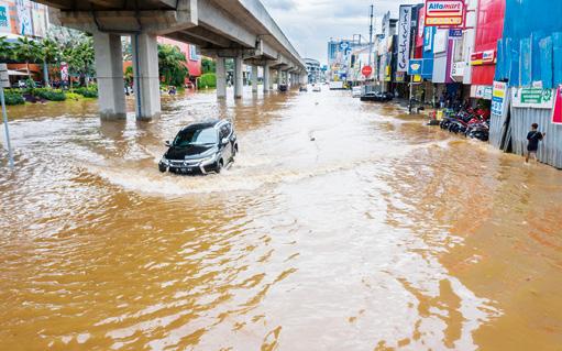
• Devastating extreme weather events, such as floods or extreme droughts.
• Rising sea levels because of melting ice and warming water.
• More endangered species.
• Depletion of natural resources.
• More diseases and health problems.
Mitigation and adaptation measures
To combat climate change, reduce its negative consequences and benefit from the opportunities it can create, a series of measures have been put in place: Improving energy efficiency, focusing on renewable energies; reforesting forests; promoting public transport and sustainable mobility; and creating protocols for action for climate emergencies.
Effects on our community
Average temperatures have risen by almost two degrees in recent years.
Also, precipitation has changed, which is no longer as abundant or distributed seasonally in the same way. There are more droughts in the last five years, drought periods have increased over the last five years, and torrential rains are more frequent.
This has a direct impact on our landscapes.
GITs
Geographic information technologies (GIT) are a set of technologies that make it easier to collect, use and analyse environmental data the collection, use and analysis of environmental data, such as remote sensing (RS), global positioning systems (GPS) and geographic information systems (GIS).
These technologies use GPS to make maps of a specific area and connect them to the most relevant study aspects.
This makes it easier to analyse things such as precipitation, pollution levels and the relationships between them.
GIT in meteorology and climatology
Thanks to GIT, extreme meteorological phenomena such as hurricanes, torrential rains, etc. can be identified and prevented.
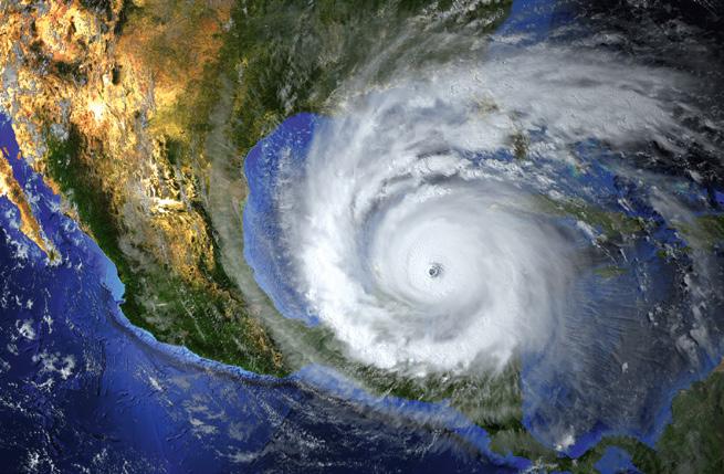
Maps are produced that predict the approximate risk level by adding hazard and social and economic factors in a specific territory.
GIT can also be used to collect data on climate change evolution, such as locating areas with abnormal temperatures, establishing how natural atmospheric processes affect global warming, creating predictive models of its consequences, etc.
1 I think, I’m interested, I investigate What is the relationship between climate change and the increase in fires in recent years?
2 Investigate how other activities that can use GIT. Which of these applications do you find most useful? Why do you think so? Discuss with your classmates.
3 Why are GIT useful for climatology and meteorology?
4 Search for information on cases where GIT has been used as a tool in fire containment or firefighting. Share the results of your search with the rest of the class.
Take note!
GIT has designed a 3D simulator that predicts how a fire will behave, which areas it will affect and where it will move. All this information is shown on a map, meaning we can make better decisions.


