6 minute read
Skitouren | Skitour


Skitouren
Ski mountaineering
Legend for ski tours: Aufstieg = Ascent (time) | Höhenmeter = Altitude meters | Schwierigkeit = Difficulty (leicht = easy, schwierig = difficult) | Ausgangspunkt = Starting point
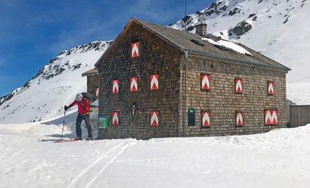
Kals a. G. – Bergertörl/Glorerhütte 2.642 m
Aufstiegszeit: 2 bis 2,5 Std. | Höhenmeter: circa 700 m Gebirge/Tourengebiet: Glocknergruppe | Schwierigkeit: leicht bis mittel | Ausgangspunkt: vom Parkplatz Glocknerwinkel (1. 920 m) beim Lucknerhaus in Richtung Osten. Anfahrt per Auto über die Kalser Glocknerstraße, ca. 7 km von Kals, großer Parkplatz vorhanden. Die Aufstiegsspur folgt anfangs einem breiten Forstweg, der bei einer Alm vorbeiführt und in mehreren Kehren an Höhe gewinnt. Auf 2.200 m geht dieser bei einer kleinen Heuschupfe in freies Gelände über und wir schreiten über mäßig steile Hänge taleinwärts. Nach einer kleinen Kuppe wird der Blick frei auf die Glatzschneid. Wir halten uns nach einer kurzen Hangquerung noch etwas im Muldengelände, bevor wir der Hauptspur Richtung Glorerhütte auf dem Bergertörl folgen. Abfahrt entlang der Aufstiegsspur.
Die Glorer Hütte ist auch im Winter durchgehend geöffnet.
Varianten: Weißer Knoten 2.878 m, Gipfelgrat zurück zum Medelsattel There is a large car park via Kalser Glocknerstraße, approx. 7 km from Kals. The ski track initially follows a wide forest path that leads past an alpine pasture and increases in height in several bends. At 2.200 m this turns into open terrain at a small haystack and we walk over moderately steep slopes into the valley. After a small knoll, the view of the Glatzschneid becomes clear. After a short slope crossing, we stay in the hollow area for a while before we follow the main lane towards Glorerhütte on Bergertörl. Descent along the ascent track. The Glorer Hütte is continuously open in winter.

Prägraten a. G. – Wunalm 2.357 m
Aufstiegszeit: 2,5 bis 3 Std. | Höhenmeter: 960 Hm Gebirge/Tourengebiet: Venedigergruppe | Schwierigkeit: leicht - mittel Ausgangspunkt: Prägraten, Kapelle in Wallhorn (1.401 m) begrenzte Parkmöglichkeit Der Aufstieg führt ausgehend von der Kapelle Wallhorn - zwischen den beiden “Winkler-Bauernhöfen” steil ansteigend über die sogenannte “Heuzieher-Riese” (Waldgelände) bis zur Grießeralm. Nach Überqueren des Fahrweges (Wegweiser) führt die Skiroute in nordöstlicher Richtung weiter bis zur Angstingeralm. Von hier bewegt man sich über flacheres Gelände bis zu einer kleinen im Wald versteckten Jagdhütte. In zahlreichen Spitzkehren geht es nun in nördlicher Richtung bergauf bis die “Wunalm” ins Blickfeld rückt, und das Tourenziel erreicht ist. Ein erhabener Ort direkt unterhalb der steil aufragenden Wunwand, der einen schönen Ausblick auf die Dreitausender der Lasörlinggruppe bietet. The climb leads from the chapel Wallhron - between the two “Winkler-Bauernhöfen” steeply rising over the so-called “Heuziehe-Riese“ (forest terrain) to the Grießeralm. After crossing the forest road (shield), the ski route continues north-east to the Angstingeralm. From here you move over flatter terrain to a small hunting lodge hidden in the forest. In numerous U-turns it is now in a northerly direction uphill till the “Wunalm” moves in the field of vision, and the tour destination is reached. A sublime place directly below the steeply rising Wunwand, that has a beautiful view to the three-thousanders of the Lasörlinggruppe offers.

Matrei i. O. – Hochgasser 2.922 m
Aufstiegszeit: circa 4 – 5 Std. | Höhenmeter: 1.410 Hm Gebirge/Tourengebiet: Granatspitzgruppe | Schwierigkeit: mittel Ausgangspunkt: Matreier Tauernhaus (1.512 m) Vom Parkplatz beim Matreier Tauernhaus geht man Richtung NNW durch lichten Wald und dann über mäßig steile Hänge hinauf zur Grünseehütte. Von dort steigt man zunächst weiter über einen sanft ansteigenden Hang auf und weiter entlang des Bergrückens des Messeling, bis man zum Grauen See gelangt. Von dort sieht man den Gipfelaufbau des Hochgassers und erreicht über mäßig steile Hänge den Gipfel. Abfahrt: wie Aufstieg. From the car park at Matreier Tauernhaus, head towards NNW through sparse forest and then over moderately steep slopes up to Grünseehütte. From there you continue on a gently rising slope and continue along the ridge of the Messeling until you reach the lake „Grauen See“. From there you can see the summit of the Hochgasser and reach it over moderately steep slopes. Descent: like ascent.
Skitouren Bewerbe Osttirol Infos zur SKIBO-TOUR-2021 auf: www.skibo.at

Aufstiegszeit: circa 4 Std. | Höhenmeter: 1.530 Hm Gebirge/Tourengebiet: Lasörlinggruppe | Schwierigkeit: mittel Ausgangspunkt: Marcherhöfe (1.360 m). Alternativ in Welzelach (200 Hm mehr Aufstieg) Die Skitour beginnt bei den Parkplätzen im Bereich der Marcherhöfe. Zunächst folgt man dem Forstweg bis zur zweiten Kehre (1.440 m). Dort verlässt man diesen und steigt teilweise sehr steil über den Sommersteig hinauf bis zur Marcher Alm (1.740 m) oder alternativ dem Forstweg bis zur Marcher Alm folgend, da dieser bedeutend gemütlicher zu begehen ist. Weiter geht es in südlicher Richtung entlang eines breiten Kammrückens durch lichten Wald aufsteigend bis auf den Bläß (2.225 m). Von hier aus marschiert man westwärts leicht ansteigend in eine große Mulde. Leicht rechts haltend durch eine kleinere Scharte, bei einer kleinen Almhütte (2.390 m) vorbei, bis zum Gipfelhang. Diesen überwunden kommt man auf den Südostgrat und weiter bis zum Gipfel. Abfahrt: vom Gipfel aus geht es zunächst Richtung Süden in eine große Senke. Dann fährt man in Richtung Osten durch Mulden in einen großen Kessel. Von hier aus weiter durch bewaldetes Gebiet (Vorsicht! Einige Stacheldrahtzäune!) in nordöstlicher Richtung und etwas beschwerlich bis zur Marcher Alm. Nun kommt man in Anlehnung zum Aufstieg durch Waldlichtungen zum Forstweg und über diesen zurück bis zu Ausgangspunkt.

The ski tour starts at the parking in the area of the Marcherhöfe. First follow the forest road to the second U-turn (1,440 m). There you leave it and climb very steeply over the Sommersteig up to the Marcher Alm (1,740 m) or alternatively following the forest road to the pasture, as this is much more comfortable to commit. Continue south along a broad ridge through a sparse forest to the Bläß (2,225 m). From here you march westwards slightly uphill into a large hollow. Slight right through a small gap, past a small alpine hut (2,390 m), to the summit slope. Passing it you get on the southeast ridge and up to the summit. Descent: from the summit, head south to a large syncline. Then you drive east through hollows in a large cauldron. From here continue through wooded area (beware! some barbwire!) In a northeasterly direction and a bit arduous to the Marcher Alm. Now you come like at ascent through wood glades and back on the forest road to the starting point.
Schutzhütten für Skitourengeher Alpine huts for ski mountaineers • Glorerhütte, 2.642 m, Tel. +43 664 3032200 • Defreggerhaus, 2.964 m, Tel. +43 676 9439145 oder Tel. +43 664 2412059 • Essener-Rostocker Hütte, 2.208 m, Tel. +43 4877 5101 • Eisseehütte, 2.521 m, Tel. +43 680 2041698 • Johannishütte, 2.521 m, Tel. +43 4877 5150 • Neue Prager Hütte, 2.796 m, Tel. +43 664 6304186 • Stüdlhütte, 2.802 m, Tel. +43 4876 8209
Auskunft über die Winteröffnungszeiten der Schutzhütten erhalten Sie in den Tourismusinformationen sowie unter www. osttirol.com
Information about the winter opening hours of the alpine huts you get at the tourist offices and
online at www.osttirol.com
Skitourenkarten (Maßstab 1:50.000 und 1:25.000) sind in den Tourismusinformationen der NationalparkRegion Hohe Tauern Osttirol erhältlich. Ski tour maps (scale 1: 50,000 and 1: 25,000) are available in the tourist information section of the Hohe Tauern National Park East Tyrol.


