7 minute read
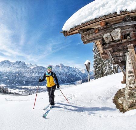
Skitouren Skitour


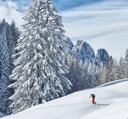
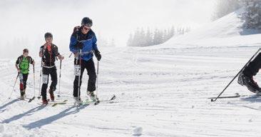
Ski mountaineering
Austria Skitourenfestival
Advertisement
Aktuelle Informationen auf | Actual information on
www. austria-skitourenfestival.com
18. Tristacher Nachttourenlauf 26.02.2021
Das Vollmond-Skitourenspektakel für Jedermann.
Aufgrund der Covid-Maßnahmen geänderter Modus! Alle Informationen dazu und Anmeldung ab Jänner 2021 auf: www.nachttourenlauf.at The full moon ski touring spectacle for everyone. In case of covid-restrictions the modus is changed! All important informations and inscription (from January 2021) on : www.nachttourenlauf.at
Skitouren Bewerbe Osttirol Infos zur SKIBO-TOUR-2021 auf: www.skibo.at
Hier finden Sie eine kleine Auswahl an Touren, die „relativ lawinensicher“ sind. Trotzdem muss man sich entsprechend verhalten und die Lawinenausrüstung mithaben ... man befindet sich in alpinem Gelände! In jedem Fall empfehlen wir die Dienste eines professionellen Berg- und Skiführers. Infos bei der Tourismusinformation Lienzer Dolomiten, Tel. +43 50 212-400. Leihausrüstung | Rental equipment: in Joachim‘s Skishop siehe Seite 17 | see page 17 The holiday region Lienz Dolomites offers a wealth of ski touring opportunities. Here you will find a small selection of tours that are “relatively avalanche safe”. Nevertheless, one must behave accordingly and have the avalanche equipment ... you are in alpine terrain! In any case, we recommend the services of a professional mountain and ski guide. Information at the Tourist Information Lienz Dolomites, Tel. + 43 50 212-400.
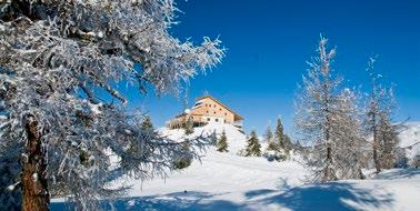
Tristach – Kreithof > Dolomitenhütte 1.620 m
Für absolute Skitouren-Neulinge und jene, die in der Gelände-Abfahrt noch nicht so versiert sind emfpiehlt sich als Einstiegstour die Skipiste hinter‘m Kofl in Tristach. Obwohl weit und breit kein Skilift in Sicht ist, werden die Almwiesen zwischen Kreithof und Dolomitenhütte schon seit Jahrzehnten mit einem Pistengerät präpariert. Ausgangspunkt: Parkplatz Kreithof (gebührenpflichtig). Streckenverlauf: Der Skipiste entlang bis direkt vor die Dolomitenhütte. Abfahrt: wie Aufstieg über Skipiste. Aufstiegsdauer: ca. 1,5 Stunden. 570 Hm. For absolute ski tour beginners and those who are not well versed in deep snow skiing, the ski slope behind the „Kofl mountain“ in Tristach is the perfect beginners tour. Although there is no ski lift in sight, the alpine pastures between the Kreithof and the Dolomitenhütte have been prepared with a piste machine for decades. Starting point: Parking Kreithof (fee). Route: Follow the ski slope until you reach the Dolomitenhütte. Descent: like ascent. Ascent time: approx. 1.5 hours. 570 Hm.
Lienz – Faschingalm > Goisele 2.433 m
Ausgangspunkt: Parkplatz Faschingalm. Streckenverlauf: Entweder am Rand der Skipiste oder die Route zw. der Piste und der alten Schlepplifttrasse (2 mal wird die Piste gequert) - auf Höhe der Faschingalm Bergstation folgt man dem breiten Rücken hinauf bis zum Steinermandl (Bergstation Sessellift) - über das Schoberköpfl weiter zum Goisele. Abfahrt: über die Skiabfahrt zur Talstation Faschingalm. Aufstiegsdauer: ca. 2 Stunden. 800 Hm. Starting point: Car park Faschingalm. Route: Either on the edge of the ski slope or the route between the slope and the old t-bar lift line (twice the track is crossed) - at the Faschingalm mountain station follow the broad ridge up to the Steinermandl (chairlift top station) - continuing over the Schoberköpfl up to Goisele. Descent: via the ski run to the valley station Faschingalm. Ascent time: approx. 2 hours. 800m.

Osttirols Ausflugsziel Nr. 1
Die Straße zu Österreichs höchstem Berg, dem Großglockner (3.798 m).
www.glocknerstrasse.at 1325 - 2000 m
Lienz – Hochsteinhütte über Russenweg 2.022 m
Ausgangspunkt: Talstation Hochstein-Bergbahn. Streckenverlauf: Hinauf zum Schloss Bruck - 50 m hinter Schloss Bruck zweigt ein Rodelweg rechts ab Richtung Moosalm - diesen Weg weitere 50 m folgend - dann links ab (direkt beim Wasserschloss unscheinbarer Waldpfad) - hier beginnt der Steig, dem man bis zur Hochsteinhütte folgen kann. Dabei überquert man den Fahrweg einmal bei der Moosalm und weiter oben den Rodelweg zur Sternalm. Im oberen Bereich wird der Wald etwas lichter und an der Waldgrenze liegt die Hochsteinhütte. Abfahrt: über die Skipiste zum Ausgangspunkt. Aufstiegsdauer: ca. 3 - 3,5 Stunden. 1275 Hm. Starting point: valley station Hochstein ski lifts. Route: Up to castle Schloß Bruck - 50 m past the castle, a toboggan track branches off to the right towards Moosalm - follow this road for another 50 m - then left (a forest path directly at the water reservoir) - here begins the track, which you can follow till the Hochsteinhütte. You cross the track once at the Moosalm and further up the toboggan run down from the Sternalm. The upper part of the forest is slightly sparse and at the treeline lies the Hochsteinhütte. Descent: via the ski slope to the starting point. Ascent time: approx. 3 - 3.5 hours. 1275m.
Iselsberg – Strasskopf 2.401 m
Ausgangspunkt: Gasthof Schöne Aussicht, Iselsberg. Streckenverlauf: Vom Parkplatz, kurz vor dem Gasthof Schöne Aussicht den Schildern „Zur Winklerner Hütte“ folgen (mehrmals kreuzen der Rodelbahn) zur Lugger Alm - über den Geiersbühel Richtung Winklerner Hütte - oberhalb der Hütte über einen Rücken weiter zum Gipfelhang (noch 350 Hm). Abfahrt: Zurück auf gleichem Weg bis oberhalb der Winklerner Hütte - links abbiegen direkt zur Hütte - weiter meistens auf der Forststrasse bis zur St. Benedikt Kirche - gleich nach der Kirche links die weiten Wiesenhänge hinab nach Winklern, (1500 Hm). Mit dem Taxi zurück zum Ausgangspunkt. Aufstiegsdauer: ca. 3 - 3,5 Stunden. 1100 Hm. Starting point: Gasthof Schöne Aussicht, Iselsberg. Route: From the car park, just before the Gasthof Schöne Aussicht, follow the signs „Zur Winklerner Hütte“ (several times crossing the toboggan run) to the Lugger Alm - via the Geiersbühel in the direction to Winklerner Hütte - above the hut over a ridge and the last hillside up to the summit (still 350 m), Descent: Back on the same path to the spot above the Winklerner hut - turn left directly to the hut - continue mostly on the forest road to the St. Benedict church - just after the church left the wide meadow slopes down to Winklern, (1500 Hm). By taxi back to the starting point. Ascent time: approx. 3 - 3.5 hours. 1100 hm.
Tristach – Kreithof > Auerling 2.026 m
Ausgangspunkt: Parkplatz Kreithof (gebührenpflichtig). Streckenverlauf: Über Wiesen (als Schipiste präpariert) hinauf zur Dolomitenhütte - weiter über den Weg bis man wieder links über Wiesen hinauf abzweigt - nach kurzem Aufstieg erreicht man die Weisssteinalm - in der Folge zieht die Spur direkt auf die Laserzwand zu - nach etwa einer 3/4 Std. erreicht man den - den Dolomiten vorgelagerten Waldrücken - den Auerling. Abfahrt: wie Aufstieg. Aufstiegsdauer: ca. 2,5 - 3 Stunden. 1000 Hm. Starting point: Parking Kreithof (fee). Route: Via meadows (prepared as a ski slope) up to the Dolomitenhütte - continue on the path until you turn left again over meadows - after a short ascent you reach the Weisssteinalm - then the track moves directly to the Laserz-wall - after 45 minutes you reach the the Auerling (forest crest in front of the Dolomites). Descent: like ascent. Ascent time: approx. 2.5 - 3 hours. 1000 hm.
Tristach – Kreithof > Karlsbaderhütte > Ödkarscharte 2.596 m
Ausgangspunkt: Parkplatz Kreithof (gebührenpflichtig). Streckenverlauf: Über Wiesen (als Schipiste präpariert) hinauf zur Dolomitenhütte – weiter über den Forstweg zur Insteinalm. In der anschließenden Linkskurve über Abkürzung durch einen flachen Graben Richtung Marcher Stein. Ab hier ist die Karlsbader Hütte zum ersten Mal ersichtlich. Über schönes Wiesengelände schwingt sich die Spur zur Schutzhütte. Bei kritischer Lawinensituation sollte hier die Tour ihren Abschluss finden und die steilen Kare gemieden werden. Bei günstigen Verhältnissen eröffnen sich dem Skitourengeher mehrere Möglichkeiten. Mit dem Weiterweg zur Ödkarscharte sei hier eine beliebte Variante herausgegriffen. Zwischen dem Felsbollwerk Seekofel und der kühnen Teplitzerspitze durchbricht dieses Hochkar die raue Felslandschaft der Lienzer Dolomiten. Der steile Schlusshang in die Scharte erfordert gute Spitzkehrentechnik und lawinenkundliches Beurteilungsvermögen. Abfahrt: Die Abfahrt erfolgt entlang der Aufstiegsspur. Bei perfekten Verhältnissen können versierte Geländefahrer auch über das Mohamedanerkar abfahren ... mit kurzem Aufstieg zum Kerschbaumer Törl und von dort wieder Richtung Marcher Stein. Aufstiegsdauer: c.a 3 Stunden bis zur Karlsbader Hütte – ca. 4,5 Std. bis Ödkarscharte. 1500 Hm. Starting point: Car park Kreithof (chargeable). Route: Via meadows (prepared as a ski slope) up to the Dolomitenhütte - continue over the forest path to the Insteinalm. At the following left-hand curve over shortcuts through a flat trench in direction to "Marcher Stein". From here, the Karlsbader Hütte is visible for the first time. Over beautiful meadows the trail swings to the hut. In case of a critical avalanche situation, the tour should end here and the higher regions should be avoided. In favorable conditions, the ski alpinist has several possibilities. With the way up to the Ödkarscharte here a popular variant is picked out. Between the peaks of Seekofel and Teplitzerspitze this cirque breaks through the rough rock skyline of the Lienz Dolomites. The steep final slope up to the saddle requires good kick turn skills and avalanche assessment competencies. Descent: like ascent. In perfect conditions, savvy all-terrain-skiers can also descent down the Mohamedanerkar ... with a short ascent up to Kerschbaumer Törl and from there again in direction to "Marcher Stein". Ascent time: c.a 3 hours to Karlsbader Hütte - approx. 4.5 hours to Ödkarscharte. 1500 hm.