In 1866, Charles Goodnight and Oliver Loving began driving herds of cattle from Texas, up through New Mexico and along the Pecos River to supply beef to Navajos and Mescalero Apaches at the Bosque Redondo reservation near Fort Sumner, as well as to settlers and military outposts. The small Hispanic community known as Rio Hondo, already in use by Hispanic farmers and sheep ranchers for its tall grasses and nearby rivers, had begun in the 1850s and was an ideal location to camp and rest along the cattle trail. By about 1868, when James Patterson built a 15’ x 15’ trading post at the confluence of the Pecos and Hondo Rivers, Rio Hondo already consisted of several “crude adobe shacks,” as reported in a 1867 survey. Although records are sparse, it is said that after the 16th century colonizing expeditions of Francisco Vásquez de Coronado, Antonio de Espejo, and Gaspar Castaño de Sosa, small populations of Spanish immigrants settled in the area that is now present-day Roswell and Lincoln. Subsequently, bands of Mexican immigrants and Native Americans developed encampments and began cultivating the land. Later, between 1840 to 1865, Hispanic farmers and sheepherders arrived from Mexico, Texas, and northern New Mexico, and sometime in the 1850s, Rio Hondo was established as one of the earliest Hispanic settlements in eastern
New Mexico after New Mexico became a US territory. In the years following the Civil War, the arrival of the railroad and the discovery of artesian waters helped to encourage Anglo farmers and ranchers to acquire land in and around Roswell through the Homestead Act, displacing nearby Hispanic populations. However, while other Hispanic settlements were abandoned—like La Plaza de Missouri to the west and El Berrendo to the north—Rio Hondo continued. Excluded from many of Roswell’s services, in 1902, twenty-four charter members organized La Sociedad de Unión Fraternidad Mexicana de Roswell—a mutual aid society for social and financial support for the Hispanic community. The district maintained its independence and had its own grocery stores, bars and restaurants, clinic, community center, school, and churches including St. John the Baptist Catholic Church which had a congregation of 130 families by 1904. Many of the men raised livestock, while the women tended gardens, sewed blankets and clothes, and made goods for resale as a means to lessen their dependency on the city. By 1912, street names were changed to reflect a more Anglo sensibility (Calla Alamosa became Mulberry Street, for instance) and the area was designated the Acequia Subdivision of Roswell. Later, the district came to be
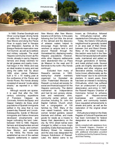
known as Chihuahua, followed by Chihuahuita—named after residents from Chihuahua, Mexico. Today, the historic Chihuahuita neighborhood is generally located in an area east of Main Street, between 2nd and Bland Streets. Many of the oldest houses in this section were built in the New Mexico Vernacular style with adobe walls, maintained and added on through generations of families, and metal pitched roofs. Several yards are brightly decorated with grottoes and other religious and decorative articles, including the home known affectionately as the “toilet house” due to its commode planters. In recent years, there has been an interest in revitalizing Chihuahuita, which has suffered from an undercurrent of poverty, deterioration, and crime. In 1987, the Roswell Hispano Chamber of Commerce formed to enhance support of Hispanic-owned businesses and community growth, and community leaders have requested enhancements to streets and parks, as well as the restoration of the original street names. Chihuahuita is listed on the State Register of Cultural Properties and has been nominated for federal designation as a historic district.
Chihuahuita
Chihuahuita today
Article compiled with assistance from the Roswell Hispano Chamber of Commerce and MainStreet Roswell with additional information provided by articles and text by Deanna Cheney and Elvis Fleming.
www.roswellcentennial.org 34