INNOVATION
Innovation Researchers discovering the past: ancient Aboriginal archaeological seabed preserved
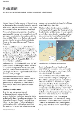
submerged archaeological sites off the Pilbara coast in Western Australia.
Human history is being uncovered through new archaeological discoveries in Australian seabeds when water levels were much lower than today, uncovering the land where people once lived.
The team of specialists studied navigation charts, geological maps and archaeological sites located on the land to narrow down prospective areas before surveying the seabed using laser scanners mounted on small planes and highresolution sonar towed behind boats.
Archaeologists can only speculate about how people used those now-submerged lands, and if any traces remain today. A recent report in the journal PLOS ONE, was on the first submerged ancient Aboriginal archaeological site to be found on the seabed, in waters off Western Australia. It is theorised that when people first arrived in Australia as early as 65,000 years ago, sea levels were roughly 80 metres lower than today. Fluctuating sea levels continued to fall as the global climate cooled. As the world headed into the last Ice Age, which peaked around 20,000 years ago, sea levels dropped to 130 metres lower than they are today.
Location maps of the study area and seabed sites.
Then between 18,000 and 8,000 years ago the world warmed up. Melting ice sheets resulted in sea levels rising and Tasmania was cut off from the Australian mainland around 11,000 years ago. New Guinea separated from Australia around 8,000 years ago.
In the final stage of research, a team of scientific divers conducted some underwater archaeological surveys to examine physically, record and sample the seabed. Two underwater archaeological sites were discovered in the Dampier Archipelago. The first of these, Cape Bruguieres, has hundreds of stone artefacts, on the seabed at depths down to 2.4 metres. At the second site, in Flying Foam Passage, traces of human activity were discovered at a submerged freshwater spring located 14 metres below sea level, which included at least one confirmed stone cutting tool made from locally sourced material.
This sea-level rise flooded 2.12 million square kilometres of land on the continental shelf surrounding Australia. Thousands of generations of people would have lived out their lives on these landscapes now under water. Landscapes under water Over the last four years a team of archaeologists, rock art specialists, geomorphologists, geologists, specialist pilots and scientific divers have been working on the Australian Research Council’s funded ‘Deep History of Sea Country Project’. Working in collaboration with the Murujuga Aboriginal Corporation, it has worked to find and record www.graduatehouse.com.au
Research into these sites, consisting of environmental data and radiocarbon dating show these sites must have been older than 7,000 years when they were submerged by rising seas. The study shows archaeological 28