7 minute read
The Human Effect

from Red Alert

THE HUMAN EFFECT
Tracking and understanding the impact human beings have on the environmental. By Mike Lane
Regardless of which side of the aisle you sit on, it’s hard to ignore the growing amount of scientific research and data on the environmental impact human beings have on Earth. And while scientists are just beginning to understand many of these effects, they need more evidence and information to minimize and mitigate our impact. Some degree of change is natural. It can be slow, gradual and continual — rivers flow and create wear on the surrounding land, deserts shift as air circulates around and through them, and trees grow and affect their environments with subterranean root systems and overhead canopies.
At other times, change is sudden and drastic. Hurricanes are devastating when they make landfall, and floods and fires wreak destruction wherever they occur. While these may seem like natural occurrences, the degree to which such environmental disasters are influenced by human activities is still being studied. What’s certain is that humans do change the world in significant ways. We build cities, we dig mines, we plant fields of agricultural crops. Sometimes it’s easy to see these and other small, fast changes — like when land is cleared to make room for a new school — but it’s harder to track the wider, slower changes happening to the planet.
Enterprising researchers are using geospatial technologies to collect, monitor and understand all the ways human activities are changing the planet. From the migration of river deltas to the construction of man-made islands in Dubai, the transformations are constant. It’s impossible to address every avenue of change, but three specific university research projects are providing data and insight that can be applied to assess and better understand our environmental impact on Earth.
Protecting elephants in Africa
As the human population continues to grow in Africa, elephants’ habitats are being repurposed for agriculture and settlement. To plan long-term, sustainable solutions, it is necessary to have accurate data on elephant numbers, migration patterns and locations. A monitoring system that uses remote sensing and Machine Learning can identify herds and better protect them from land use conflicts.
Human residents use several techniques to deter elephants from entering their cropland and inhabited areas. These techniques include chili fences and bombs, bee fences, and technological solutions designed as early warning systems for communities. But the elephants need to be kept safe too.
High-resolution satellite imagery combined with remote sensing and Machine Learning can be used to monitor and protect herds, and a group of researchers at the University of Oxford is doing just that. They partnered with the Elephants Without Borders non-profit organization, which contributed GPS tracking collars for herds in the Kavango Zambezi Transfrontier Conservation Area in Sub-Saharan Africa. The researchers accessed multispectral imagery and used remote sensing to locate areas of interest where a concentration of elephants could be identified. Images were then processed, and the researchers developed a convolutional neural network (CNN), an algorithm that automates the detection of herds in satellite images. To do this, the GPS collar data was cross-referenced with image coordinates, which provided the algorithm with exact examples of what elephants look like from space.
Additionally, training data was collected from Addo Elephant National Park in South Africa, where there is a high concentration of elephants in a relatively small area. After labelling satellite images by drawing bounding boxes around individual elephants and non-elephant objects (e.g. trees) in the landscape, Machine Learning was applied to teach the machine the difference.
Eventually, the algorithm will be smart enough to detect wild elephant populations in images without relying on GPS collar data. There are already a number of CNNs that are more accurate than human detection in challenging image classification and object detection areas. With enough training data, CNNs can learn complex, distinctive features of objects in a short time.
Developing a close to real-time monitoring technique will allow scientists to track herds more accurately and efficiently, enabling more effective conservation planning and management.
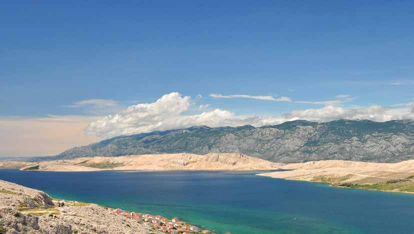
Croatia’s Pag Island suffers from extreme soil erosion due to a combination of harsh climatic conditions and intensive grazing and deforestation caused by humans
With human population growing in Africa, habitats of elephants are being repurposed for agriculture and settlement, which may impact migration patterns and access to resources

With human population growing in Africa, habitats of elephants are being repurposed for agriculture and settlement, which may impact migration patterns and access to resources
Surveying soil erosion in Croatia
Pag Island, part of Croatia, also needs the attention of conservationists. It’s suffering from extreme soil erosion, thanks to a combination of harsh climatic conditions and human influence caused by intensive grazing and deforestation. The remaining soil sediments that make up the island’s unique landscape are under threat, and researchers are working to create digital models of the situation and prevent further erosion.
Erosion can lead to negative outcomes, like soil degradation and removal, resulting in land deprivation and decreased agricultural productivity. A PhD student at the University of Zadar in Croatia has set out to model and better understand the soil erosion mechanism and intensity. He hopes that his research on Pag Island will be the basis for planning soil erosion limitation and mitigation measures that could prevent further endangerment of valuable soil sediments and grasslands. Research focusing on Pag Island is particularly valuable due to the island’s unique bare, karstic landscape and specific scarce vegetation cover. Soil sediments are the basis of the Mediterranean grassland environment, which is part of Natura 2000, a network of protected core breeding and resting sites for rare and threatened species in the European Union.
Within his PhD program, soil erosion is studied on the macro, meso, and micro levels using high-resolution multispectral imagery, LiDAR, UAV photogrammetry and 3D digital surface models to detect and map remaining soil sediments and main erosion hotspots on Pag Island. He is also studying the influence of specific climate change-related intensive rain events by collecting meteorological data. His findings may help scientists preserve Pag Island’s natural landscape and maintain its remaining soil cover. Land quality and classification is a highly important factor in the health of the planet — so important that another researcher 5,000 miles away is also working to record changes in the land where she lives.

According to the US Census Bureau, the Atlanta metropolitan area had the nation’s fourth highest population growth between 2010-2018
Tracking changing land use in Atlanta,
Georgia Since 1970, Georgia has experienced a population boom — the number of residents grew from 4.7 million to 9.6 million. At the same time, land use and land cover have evolved, especially in larger cities According to the US Census Bureau, the Atlanta metropolitan area had the nation’s fourth highest population growth between 2010-2018 such as Atlanta. Satellite imagery and analysis algorithms are being used to assess the effect that agriculture, mining, deforestation and urban development have on the Earth’s surface.
Change detection is a process that measures how the features of an area have changed over time; it often involves comparing aerial photographs and satellite imagery. A Geographic Information Science and Technology graduate student completing her master’s degree at the Georgia Institute of Technology is working to determine how urbanization has affected Georgia by comparing Landsat satellite imagery from the early 1970s, the early 1980s and the present.
She will mosaic the imagery and run a Machine Learning analyst algorithm to generate change detection based on variables such as the normalized difference vegetation index. Once land cover classifications are complete for all three eras, a complete picture of the human effect on Georgia’s landscape will begin to emerge. Scientists can then determine what changes, if any, are necessary to sustain green space and other desirable characteristics in the state’s topography.
An image is a snapshot of a single moment in time, but it can carry a lot of valuable information. Imagery could be used to help scientists understand how deforestation impacts Chinese pandas or how coastal development and pollution in Hong Kong have led to a significant decline in white dolphins.
One of the challenges with geospatial data like the examples above is that the second you capture it, it’s outdated. So how do you extract the critical details an image contains before it’s irrelevant?
With powerful, versatile processing tools, geospatial imagery can be converted into actionable information and real location intelligence that can then be used to make decisions — like how to best mitigate humanity’s effects on nature and protect the Earth. This planet is our home, so we must do our best to learn about it and take care of it if we hope to live long, healthy, productive lives.


