compact flash cards installed in the camera. Image triggering was activated from the ground control station when the UAV reached the desired study site. Photogrammetric techniques were required to register the framebased imagery to map coordinates. Each digital frame comes with position, altitude and timing information allowing for the generation of large mosaics. The main limitations encountered for these platforms were the endurance (15-30 min) and the low flight speed (30-60 km/h), limiting the productivity to 70 - 250 hectares per flight. On top of that, foliar samples from healthy (G0), slightly damaged (G1), moderately damaged (G2) and heavily damaged (G3) oil palm trees (15-year-old) were collected for field and laboratory spectral measurements using hyperspectral handheld portable ASD field spectroradiometer (FieldSpec HandHeld).
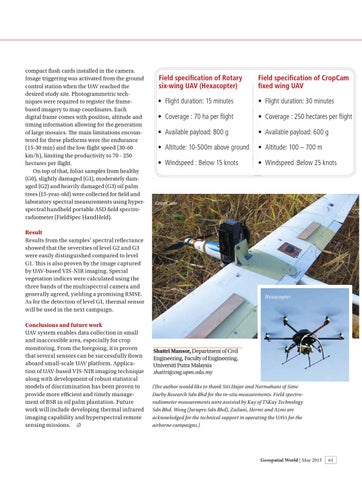
Field specification of Rotary six-wing UAV (Hexacopter)
Field specification of CropCam fixed wing UAV
• Flight duration: 15 minutes
• Flight duration: 30 minutes
• Coverage : 70 ha per flight
• Coverage : 250 hectares per flight
• Available payload: 800 g
• Available payload: 600 g
• Altitude: 10-500m above ground
• Altitude: 100 – 700 m
• Windspeed : Below 15 knots
• Windspeed :Below 25 knots
CropCam
Result Results from the samples’ spectral reflectance showed that the severities of level G2 and G3 were easily distinguished compared to level G1. Th is is also proven by the image captured by UAV-based VIS-NIR imaging. Special vegetation indices were calculated using the three bands of the multispectral camera and generally agreed, yielding a promising RMSE. As for the detection of level G1, thermal sensor will be used in the next campaign. Conclusions and future work UAV system enables data collection in small and inaccessible area, especially for crop monitoring. From the foregoing, it is proven that several sensors can be successfully flown aboard small-scale UAV platform. Application of UAV-based VIS-NIR imaging technique along with development of robust statistical models of discrimination has been proven to provide more efficient and timely management of BSR in oil palm plantation. Future work will include developing thermal infrared imaging capability and hyperspectral remote sensing missions.
Hexacopter
Shattri Mansor, Department of Civil Engineering, Faculty of Engineering, Universiti Putra Malaysia shattri@eng.upm.edu.my (The author would like to thank Siti Hajar and Normahani of Sime Darby Research Sdn Bhd for the in-situ measurements. Field spectroradiometer measurements were assisted by Kay of TSKay Technology Sdn Bhd. Wong (Jurupro Sdn Bhd), Zailani, Hermi and Azmi are acknowledged for the technical support in operating the UAVs for the airborne campaigns.)
Geospatial World | May 2013
malaysia.indd 61
61
5/7/2013 7:54:30 PM