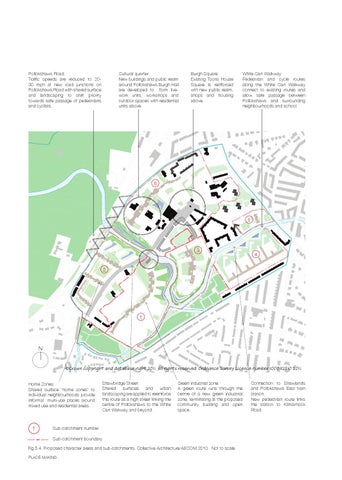
Pollokshaws Road: Traffic speeds are reduced to 2030 mph at new road junctions on Pollokshaws Road with shared surface and landscaping to shift priority towards safe passage of pedestrians and cyclists.
Cultural quarter: New buildings and public realm around Pollokshaws Burgh Hall are developed to form livework units, workshops and outdoor spaces with residential units above.
Burgh Square: Existing Toons House Square is reinforced wth new public realm, shops and housing above.
White Cart Walkway: Pedestrian and cycle routes along the White Cart Walkway connect to existing routes and allow safe passage between Pollokshaws and surrounding neighbourhoods and school.
6
5
3
4
2
1
N ©Crown copyright and database right 2011. All rights reserved. Ordnance Survey Licence number 100032510 2011. Home Zones: Shared surface ‘home zones’ to individual neighbourhoods provide informal multi-use places around mixed use and residential areas.
1
Shawbridge Street: Shared surfaces and urban landscaping are applied to reienforce this route as a high street linking the centre of Pollokshaws to the White Cart Wakway and beyond.
Green industrial zone: A green route runs through the centre of a new green industrial zone, terminating at the proposed community building and open space.
Sub-catchment number Sub-catchment boundary
Fig 5.4 Proposed character areas and sub-catchments, Collective Architecture/AECOM 2010. Not to scale. PLACE-MAKING
Connection to Shawlands and Pollokshaws East train station: New pedestrian route links the station to Kilmarnock Road.