1 minute read
From railroad to LRT


Technical datasheet
Year:2020
Advertisement
Author:Guy Farinon,adviser Cynthia Santos.
Location:Campo Grande (MS) - Brazil
Line extension:57.35km
Description: Clipping of the urban plan of the Light rail transit (LRT) lines in Campo Grande from the final graduation work.
In the city of Campo Grande, the alternatives for motorized transport are cars, motorcycles and buses, with only the latter being an option for public transport. Population growth is being accompanied by an increase in the fleet of individual transport vehicles. Choosing public transport is sometimes the last option, with more trips by car overloading traffic and slowing down the entire mobility system.
Rethinking the strategies for moving people around the city is essential, especially with a view to sustainable social and economic growth. The proposal to implement the LRT system in the urban fabric of Campo Grande is designed with the intention of benefiting the mobility of the city with a sustainable, accessible,contemporary,efficient,safe and viable project.
Based on the analyzes made of the main routes of urban vehicular displacements, the current demands of origin and destination of public transport passengers and future projections for mobility in Campo Grande, it was possible to conceive a preliminary study of the possible lines for the urban LRT system.
The study was developed with the aim of proposing the shortest routes, which met the most requested routes, which enabled integration with existing urban mobility equipment, which avoided roads with high inclinations and which passed through structured roads with 'arterial' hierarchy or 'rapid transit'.
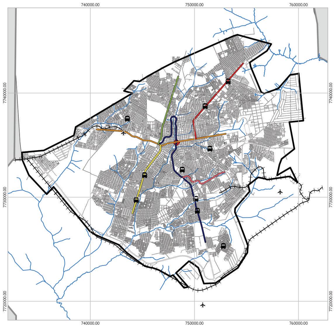
As a result of the preliminary study of the lines, a route map for the VLT lines was generated. In total, six lines are suggested, represented by colors and numbered by hierarchy of priority and relevance in relation to the system. The Blue Line is highlighted, which partially runs along the old railroad tracks in Campo Grande in the North-South direction and is part of a route studied for the implementation of LRT since 2012.
Campo Grande city map
Stage 6 of the LRT system
Legend
County border
Urban area
City blocks
Hydrography Airport
URBAN MOBILITY
Bus station
Railways
LRT Station
LRT LINES
LRT Blue line
LRT Orange line
LRT Yellow line
LRT Red line
LRT Green line
LRT Pink line
Location map
Campo Grande County
Data Source: IBGE (2020); SISGRAN (2020).
Cartography: Guylherme Farinon Gonçalves (2020).
Universal Transverse Mercator Projection (UTM) Datum SIRGAS 2000 25 South Zone.