
50 minute read
GEOtalk


The Story of the Rainwater Beer on the Dutch Cultural Fair Table
Did you know that you could drink rainwater?
Advertisement
rainwater, circular economy, climate adaptation, citizen awareness, beer Dymphie Burger (EGEA Amsterdam)
You might have seen it, next to the stroopwafels and some aged cheese on the Dutch table, if you were on time at least, because this beer is popular during Cultural Fair: A small brown glass bottle with a blue and white label, called Code Blond. It tastes quite nice, like a milder version of an IPA or a strong and bitter blonde beer; a bit peculiar, too, because it is stronger than a normal beer. “Made by an EGEAn, with rainwater from Amsterdam, collected at the campus of the university.” You might remember this beer on the next day, but suddenly you are not sure anymore. Can you even drink rainwater? And what kind of crazy students’ project got so out of hand that a commercial beer was the result? See here, the story of the rainwater beer. It all started during a project at the Amsterdam University of Applied Sciences, where a team of four interns from the MediaLAB Amsterdam (renamed to Digital Society School), a design research institute, worked together with Amsterdam Rainproof on a project to raise more awareness for the effects of extreme rainfall in Amsterdam. Extreme rainfall is occurring often in the Netherlands and can damage public and private property seriously. On the 28th of July 2014, for example, there was on average 130 mm per hour in a few hours’ precipitation in the Netherlands, nearly twice as much as the national average for July (Böcker, 2014; Eden, et al. 2018). Then, there is the second problem: Amsterdam is situated at around sea level, which means that some areas are for example two meters above sea level and others are four meters below. The rainwater flows, due to increased amount of paved areas, to the lowest parts, and sometimes has to flow from four meters below sea level to the canal at sea level, which is against gravity. Therefore, a good sewage system is necessary. The sewage system in Amsterdam is currently able to handle rainfall intensities of 20 mm per hour (Kluck, et al. 2015). So, when 95 mm are precipitated below sea level and only 20 mm can go into the sewage, 75 mm somehow have to go upwards to get into the nearest canal. This doesn’t happen: the 75 mm will stay on the streets or run into someone’s basement. Making private property resilient against such rainfall events is not only a task for the government, but also one for the citizens. Therefore, awareness has to be raised and bottom-up initiatives are needed. At the beginning of our project, we had several brainstorming rounds to think of possible products or services to raise awareness. One time, we were talking about my bachelor’s thesis, which was about the economic impact of droughts. Having too much water was actually a luxury in our eyes. Yet, we use so much water in the Netherlands. Our supervisor said that he was feeling guilty about using a lot of drinking water for his home-brewed beer. Then, we joked about using the excess of rainwater for brewing beer, because what else could you do with rainwater? After all the brainstorming, we came up with a “waterproof run”, a game, a green movement and a beer made from rainwater. Since Amsterdam Rainproof was a part of
Figure 1: Collecting rainwater on campus Source: Burger, 2016a
the waterboard (a Dutch governmental body taking care of all water related issues), brewing beer was certainly not possible, although they liked the idea of a beer made from rainwater.
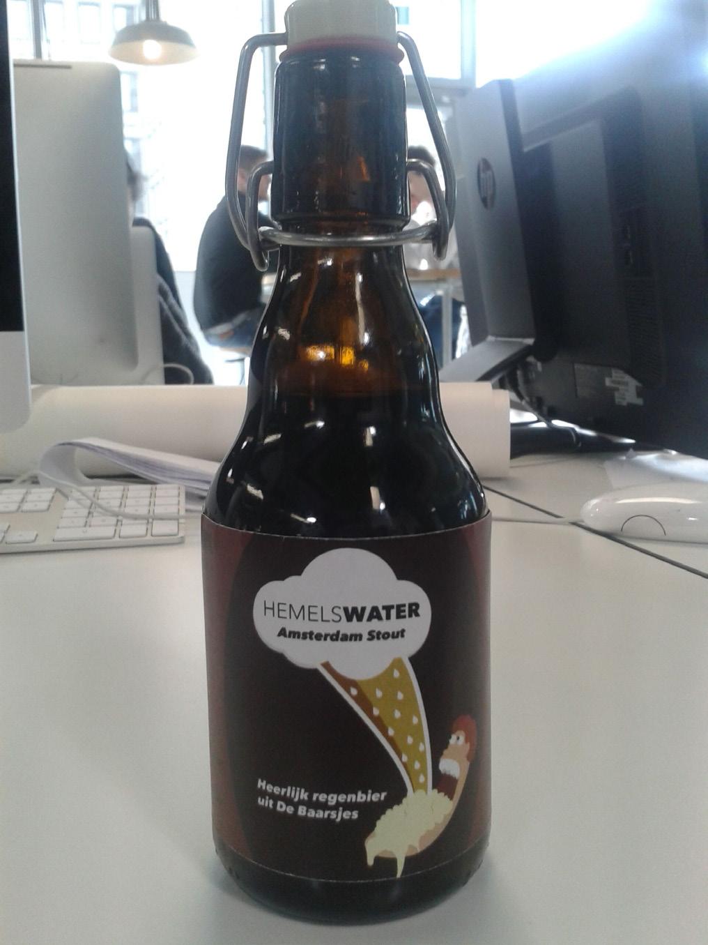
Figure 2: Our first bottle of rainwater beer, also known as the “joke bottle” Source: Burger, 2016a
As a joke, we tried to collect rainwater outside, first in pots and buckets, later with IBC tanks and tried to do a “rain dance” when it was dry for a few days. After a rainy weekend, the first beer was ready to start fermenting. The day that it would be ready to be bottled was also a presentation day of the progress of our project, so we could also present the beer there. I wasn’t able to attend the presentation, because I was representing EGEA Amsterdam at the WRC 2016 in Annaberg, Austria. I made a lot of jokes about being safe from getting sick from drinking rainwater beer and that when I would come back from the congress, nobody would be able to work, except for me. My co-workers presented the beer as a fun side project and when I came back in the office after the congress, our boss came to our table and told us that we had an hour to get ready, because we had to present the beer at the Volkshotel, a nearby club, bar, co-working space, restaurant and hotel. They wanted to sell the beer. So there we went, one of my co-workers and I presenting the beer with only one “joke” bottle, of which we were not sure whether it will explode when opened! At the presentation, there was another project presented, The Knowledge Mile. This project was founded by the University of Amsterdam, The Amsterdam University of Applied Sciences and the municipality of Amsterdam. They aimed at making two large streets, the Weesperstraat and Wibautstraat, the smartest, greenest, and most beautiful streets of Amsterdam. These streets housed a lot of offices, the city hall, the two universities and the Amsterdam Academy of the Arts. Despite all the offices, the streets were in my and many other Amsterdamians` opinion, not very pretty; there were hardly any trees and cars ruled these streets. One of the leaders of The Knowledge Mile was interested and invited us to the launch party of the project, where a local news website would also be present. We had to present our beer there as well. At the party, we presented our “joke bottle” for the second time and thought we would never hear from the Knowledge Mile again. Sometime later, we got another email from them; this time we got invited to see the green roof (or rooftop garden) on the Amsterdam University of Applied Sciences and to talk about the rainwater beer again, this time on local television. We still had the “joke bottle”, since it was very dry that month, although we created a construction next to our building to catch the rainwater in an IBC tank. After our debut on local television, we got some attention from other media, but it got a little quiet. We mainly started focusing on our project, the game

Figure 3: Brewing wheat beer in the kitchen of our institute Source: Burger, 2016b
Figure 4: The fermentation process took place in a bottle in our locker Source: Burger, 2016b

“Heroes of Rain” that aimed at raising awareness for extreme rainfall and engaging the players to also make their house and neighbourhood rainproof. We didn’t forget the rainwater beer, though; we got in contact with a brewery and started asking other companies to collect rainwater for us, such as hotels, bars and a gardening centre. Then, it finally started to rain. May 2016 was really wet after a very dry period. Finally, our topic got widely known among Europe. The Seine river in France had never been that high, there were problems in Germany (including a flooded Rock am Ring festival) and in the Netherlands there were some thunderstorms as well. We noticed that, when we were doing research for our project, more people were aware than before. With the water from our small setup, we started trying to brew some wheat beer in the office and let it ferment in our project’s locker. When the IBC tank was finally full of rainwater, we contacted the brewery and the filter company. Because we would be brewing the beer in a brewery, the water quality had to meet the same standards as “normal” drinking water, so we used a specially designed water filter to make the collected rainwater into drinking water. The brewery was only a 10-minute bike ride away from the University, but this time we could not transport one cubic meter (1000 litre or 1000 kilograms) per bike, we had to push it through the city. So we did, we gathered the strongest people from the office and pushed the water through the city centre of Amsterdam. The hard work was rewarded with an ice cold (normal water) beer. In order to make our beer even more circular, we brought the barley used for the beer to the bakery close to the university to bake a beer bread. It took a few weeks to brew the beer and let it ferment. The research project had almost ended. At the presentation of our game we served some of the rainwater beer that was brewed in the office (the bottles didn’t explode, but it was close), together with the beer bread. Approximately a week later, we got a message on Facebook in English. Someone heard of our story and was interested. The woman messaging us claimed to be working for The Guardian, a well-known British newspaper. First, we thought it was a spam message and we checked The Guardian for her name below articles. On her LinkedIn profile we found that she was actually a journalist of the Guardian, and we accepted her request to write an article about the beer. The next medium that picked up the story was the Dutch national television; we got an item in the news programme “NOS op 3”. After that, many blogs and magazines
Figure 5: Presentation of our game and the beer Source: Author’s own, 2016

Figure 6: Pushing the IBC tank with rainwater through Amsterdam Source: Burger, 2016c

wanted to write about us, and more and more bars started offering our beer to their customers. It seemed that people started to become aware about climate change and climate change adaptation. At the end of the summer, the students in the team went back to university, one went to Japan for an internship and another one started working, we left the company. However, sometimes we still contribute to the project; our designer created the new logo and I sometimes give advice

Figure 7: The different rainwater beers existing at the moment Source: Rainbeer.nl, 2018 on the quality of the rainwater and the Dutch law regarding drinking water. Right now, two years after we got on local television, Hemelswater changed its name into Rainbeer and works together with several breweries in Amsterdam, Den Helder, Leeuwarden and Nijmegen. They won a prize for the most sustainable and innovative idea in a contest for green and social start-up companies by an ethical bank in the Netherlands, and the company also gives other breweries advice about using different types of water than just conventional tap water. This beer company is the second start-up that I worked for, but the first one that I helped develop from scratch. I can recommend to everyone, that when you get a crazy idea for a product or service, find people to work with (because setting up something in a team is more fun) and just go for it. If you have a network with like-minded people, there are many opportunities. Of course, it can be really hard sometimes and very chaotic, but in the end, even if your plan will not make it, it is worth the experience.
References
Böcker, L., 2014. Climate, Weather and Daily Mobility: Transport Mode Choices and Travel Experiences in the Randstad Holland. Utrecht University.
Burger, D., 2016a. DIY: Rain beer! Medialabamsterdam.com Rainproof blog, [blog], 8 April. Available at <https://medialabamsterdam.com/rainproof/?p=82> [Accessed on March 15, 2018].
Burger, D., 2016b. Beer Update! Medialabamsterdam.com Rainproof blog, [blog], 9 May. Available at <https://medialabamsterdam.com/rainproof/?p=155> [Accessed on March 15, 2018].
Burger, D., 2016c. Another Beer Update! Medialabamsterdam. com Rainproof blog, [blog], 7 June. Available at <https://medialabamsterdam.com/rainproof/?p=16> [Accessed on March 15, 2018].
Eden, J. M., Kew, S. F., Bellprat, O., Lenderink, G., Manola, I.,
Omrani, H., & van Oldenborgh, G. J., 2018. Extreme precipitation in the Netherlands: An event attribution case study. Weather and climate extremes, 21, pp.90-101.
Kluck, J., Boogaard, F. C., Goedbloed, D., & Claassen, M.,2015. Storm Water Flooding Amsterdam, from a quick Scan analyses to an action plan. Amsterdam International Water Week.
Rainbeer, 2018. Ons bier. [online] Available at <https://www. rainbeer.nl/ons-bier> [Accessed on March 15, 2018].
The Roof of Africa - 5 Climatic Zones in 5 Days
In the north of Tanzania, close to the border with Kenya, Mount Kilimanjaro reaches up to 5,895 m a.s.l. and is therefore the tallest mountain in Africa, as well as the highest free-standing mountain in the world. It is divided into three inactive volcanoes, the Shira to the west, the Mawenzi to the east, and the Kibo with the Uhuru Peak in-between. The climate changes from tropical rainforest at the bottom, to arctic glaciers on the top. Every year about 35,000 hikers attempt the ascent. In February 2016 my family and I joined the ranks of conquerors of the Roof of Africa. This is our journey…
Day 1
The bus drops us off at the northern gate to the national park. While the porters (14 in total for the 4 of us!) try to figure out how to divide the immense mountain of luggage and provisions amongst them, we set out to follow our guide up the foot path into the rain forest. It is warm and humid but not as hot as we had imagined. For about four hours we steadily ascend through big trees and thick undergrowth. It is a forest, but not that different from what we know from the mountainous areas back home in Central Europe. Behind us soft foot steps are audible. They belong to the local children who are walking from their school, located down in the village, up to their families’ huts in the lower parts of the rain forest. They smile at us and take our hands. We cannot speak their language, but no words seem to be necessary. Only the comfortable coexistence between us brightens up the day for us all. Further up they release their muddy little hands from ours and run barefoot down some nameless path through the trees. Following the route a few hundred meters we arrive at the first camp. A wooden hut presents itself as the head quarter. A handful of bunk beds are visible from the outside, but our porters are already busy setting up the tents in the back of the hut. Satisfied with our first day at the mountain we soon retreat into our sleeping bags for the night.
Kilimanjaro, hiking, Africa, climate Lisa Witz (EGEA Amsterdam)
Day 2
Big rain drops rhythmically drum straight down onto the tent. It is time to get up for another day of hiking although there is no sound in the camp apart from the steady rain. After about half an hour one of the porters announces that tea and coffee is prepared for us in front of the tent. We get up and ready ourselves for breakfast. The rain has cooled down the temperature noticeably. After eating and packing we put on our rain gear and fill our water bottles. We set out with an umbrella and a slightly dimmed mood. The vegetation quickly turns from trees into shrubs. The horizon vanishes in a blanket of grey. Towards the end of the day we reach the cloud line and the sun starts to break through every now and then. At dinner we sit around the table and discuss whether we will or will not hike another day with wet clothes and no view. We have still not seen the summit of the mountain we are walking towards. Judging from the surroundings we could easily be back home in Germany. Finally, we climb into our tents shivering and feeling a little disappointed in this second day.
Day 3
The sun makes its way over the mountain and starts warming up the air. Even though it is cooler up here the day seems to promise warmth and sunshine. Climbing out of the tent I look to the path and follow its ascent and there
it is, the view you find on all post cards and posters of Tanzania: the smooth top of the crater is sprinkled with white spots of ice and snow and the brownish-red outlines below them remind you of an aquarelle painting. With a much better spirit we pack up our day bags and follow the path towards the eastern side of the mountain. The distance for the day is rather small and not steep at all. We reach the camp around midday and find a deliciously prepared lunch. We spend the afternoon curled up in our tents just to wake up again for another round of food for dinner. As our mood improves, we decide that we will not give up but on the contrary, will take the adventure step by step, day by day.
Day 4
Today our guide warns us about the steep part we are about to climb. Two hours in, both our backpacks and our breathing start becoming heavier. But looking back over the hill side we can see the clouds below us and looking up Figure 1: Our camp below the Mawenzi peak Source: Author’s own, 2016 we can spot the peak of the Mawenzi directly above us. To the west the crater of the Kibo is accompanying us along

the way. After four hours we are quite exhausted from the altitude and the thin air, but we slowly wind our way up. Every hill top and every stony corner makes a promise of revealing the camp but it takes another hour until we discover the green tents from afar. After sundown the temperature drops quickly and we layer up with everything we have. The night is cold and icy. As I wake up during the night to use the toilet hut, I go outside and little ice crystals drop down on my head from the tent. I hurry over the half frozen ground and back. As I look up just for a moment the most beautiful sky full with thousands of stars presents itself, here, in one of the loneliest places in the world. Only a few shivering seconds of this view make me sleep like a happy baby for the rest of the night.
Day 5
We start walking away from Mawenzi towards Kibo and our last night camp before reaching the peak. We walk, and walk, and walk. The plain seems endless with sharp winds and no spot to find cover from it for at least a few minutes. We keep on walking and putting on more clothes on the way. Every step becomes harder and harder. The destination becomes more visible but at the same time does not get any closer. When we finally reach the camp, I am completely worn out. I cannot even stand up for the obligatory group picture. I spend the rest of the day lying in the tent. At dinner all of us are still pretty exhausted, but we are not feeling too bad. Therefore we decide to see the whole adventure through and conquer also the last bit
of this mountain.

Figure 2: On our way towards the last camp before the Kibo Source: Author’s own, 2016
Day 6
Our guides wake us up around midnight. We put on all of our clothes, turn on our headlamps and start walking up the steepest of path, one after the other. All along the side of the mountain we see other groups, only visible due to their lamps. It is completely dark around us and we can only see the person in front of us. It is so cold that my fingers start to tingle and I can only stop for a few seconds to drink a little sip of water every now and then. The guide tells us to think about something nice but I can only think: one step with the right foot, one step with the left foot, breath in, breath out. The minutes and hours blur together and then, as impossible as it seemed, we made it. We are standing at the top of the crater of the highest mountain of Africa, in an arctic climate and more exhausted than ever before in our lives. We cannot even comprehend. After what seems like forever, the morning sun finally breaks through the dark and, while we are still feeling frozen to the ground, the most amazing view opens up in front of us. We could only afford a few moments standing there and watching this beauty before we make our way back down. The sun makes life and warmth slowly drip back into our bodies. For the first time we can see the mountain we just climbed lighting up in the daylight. Back in the camp we have time for a little nap and some nourishing lunch. Afterwards we pack our stuff again and walk down another four hours to the next camp.
Day 7
We start realizing that this is it. This will be the last day of our amazing hiking trip. We have just enough time to take a quick picture with everyone from our crew. Starting down the path we wish the hikers coming up the other side good luck as they have no idea what is waiting for them. The southern side of the Kilimanjaro is much warmer than the north and the vegetation changes fast from shrubs to trees. The air becomes humid and after wearing ski jackets just the day before we are now hiking in sweaty T-shirts. When we reach the entrance gate and see all the tourists and busses, the sight seems unreal. We sit down for our last hiking lunch at a real table and wait for our certificates. Some people ask us about our trip because they had just come for a day or they are about to start their own hike up the mountain. Our universal answer is: “Just do it as the locals say: Pole, pole (Slow, slow)!”

Figure 3: Group picture with the whole team including the 4 of us, our 2 guides, 1 cook and 14 porters Source: Author’s own, 2016
A Review of Volcano Hazard Prediction Using Satellite Remote Sensing
Volcanic activity may impose adverse socioeconomic impacts on both people’s livelihoods and air traffic. Satellite sensors present in orbit have the capacity to detect volcanoic precursory activity using a wide range of wavelength bands. Synthetic aperture radar interferometry and spectroradiometry are valuable techniques used nowadays in volcano monitoring. The focus of future developments in satellite remote sensing of the volcanic pre-eruptive phase is on spatial and temporal resolution image enhancement. Generally, analysis of the continuous satellite observations provides an understanding of the global volcano system and serves as a basis for hazard mitigation. volcano monitoring, volcanology Iris Mužić (EGEA Lund)
Introduction
Volcanic hazards including lava flows, mudflows (lahars), pyroclastic flows, eruption clouds and landslides that can trigger tsunami formation are numerous examples of how volcanic activity can impose a threat to communities, population health and the area’s air traffic (Hooper, Prata and Sigmundsson, 2012; Mouginis-Mark, 2000). Therefore, the ability to forecast volcanic eruptions is essential in hazard mitigation planning (Tralli et al., 2005). In general, seismic activity, surface deformation, as well as heat and gas emission stand out as precursors to volcanic unrest (Hooper, Prata and Sigmundsson, 2012; Tralli et al., 2005; Pyle, Mather and Biggs, 2013). As a result, the main objectives of this paper are as follows: How can satellite remote sensing be used to predict volcanic eruptions? How can volcanic precursory activity monitoring using satellite remote sensing be improved in the future?
Prior to the eruption, volcanoes emit gases such as water vapour, CO2 and SO2. Among these, SO2 is released in the smallest concentration, however, because of the atmospheric abundance of the other two gases (as background noise), it is the most applicable for satellite detection. The first satellite measurements of volcanic SO2 were performed in 1978 when NASA launched the Total Ozone Mapping Spectrometer (TOMS) (Global Volcanism Program, 2013). Since then, using a wide range of wavelength bands, from ultraviolet (UV) to microwave (approximately 300 nm - 30 cm), geostationary (GEO) and low Earth (LEO) orbit satellites record spectroradiometric observations of precursors to volcanic activity in the near-real-time. Spectroradiometry is utilised for both hotspot detection and gas and ash quantification (Hooper, Prata and Sigmundsson, 2012). Measuring gas and aerosol emission is performed using infrared (IR), visible and UV, while the thermal infrared (TIR) part of the electromagnetic spectrum is used for separation of the ash and SO2 in the plume and heat evaluation (Pyle, Mather and Biggs, 2013). Some examples of satellite spectroradiometers in use are geostationary Spin-Enhanced Visible and Infrared Imager (SEVIRI), Moderate Resolution Imaging Spectroradiometer (MODIS) and Advanced Spaceborne Thermal Emission and Reflection Radiometer (ASTER) (Hooper, Prata and Sigmundsson, 2012). The combination of satellites using different resolutions provides precise thermal anomaly data. As an illustration, high spatial and low temporal resolutions (e.g. ASTER) are used to produce detailed images for large thermal
flow routes (Tralli et al., 2005). (InSAR) has been used for centimetre-scale volcano surface deformation tracking, which is induced by the belowground magma movement. It can produce images during the night and penetrate through the cloud cover. Some presently used radars are TerraSAR-X and COSMO-SkyMed (Hooper, Prata and Sigmundsson, 2012; Pyle, Mather and Biggs, 2013). Reflected or emitted radiation from the Earth’s surface captured by the satellite sensors is used in volcanology for various purposes. Automatic detection of hotspots and data archiving enables a fast response to the occurring hazards. Longterm heat flux measurements provide analysis of single volcano eruption dynamics. Furthermore, quantifying the emitted ash and SO2 allows mapping as well as performing
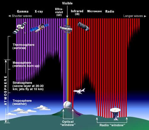
simulations and modelling of the volcano system (Hooper, Prata and Sigmundsson, 2012; Ramsey and Harris, 2013). Satellite remote sensing techniques have the capability to monitor isolated areas and provide the contemporary data which Figure 1: Detectors on the satellites capture the radiation in the whole electromagnetic spectrum. As ilother source. These adlustrated, most types of electromagnetic radiation are absorbed by the Earth’s atmosphere and are thus vantages have been used unable to penetrate to the Earth’s surface level. for online and automaData source: NASA, 2013 ted early warning systems (strombolian) eruptions over a short time scale. Further (e.g. MODVOLC) since to this, low spatial and high temporal resolutions (e.g. 2002 (Pyle, Mather and Biggs, 2013; Ramsey and Harris, MODIS) provide insight into the lower thermal volcano 2013). In other words, the information about the volcanic activity over a longer period of time (Reath et al., 2016). precursory activity is shared quickly, assisting in hazard Additionally, instruments like the Airborne Visible Infra- assessments and disaster mitigation. Space-based measureRed Imaging Spectrometer (AVIRIS) or hyperspectral in- ments thereby enable safe data collection and temporary struments like Hyperion can depict the near-surface rock information contributing to the understanding and prechemistry variations and thus determine possible debris dicting of future global volcano activities. Since the 1990s, synthetic aperture radar interferometry Future perspective is not available from any The higher spatial and temporal resolution of the produced images are the primary goals in the future development of the volcano satellite monitoring (Hooper, Prata and Sigmundsson, 2012; Ramsey and Harris, 2013). Moreover, progress in measurements above the snow, ice and dense vegetation areas should be made. The Meteosat Third Generation (MTG) is a system of satellites which will record both images and sound. This makes it possible to introduce the volcanic lightning identification (LI).
The Geostationary Operational Environmental Satellite (GOES-R) will enable rapid data dissemination and include more spectral channels as well as the volcanic ash height and SO2 abundance detection (Hooper, Prata and Sigmundsson, 2012). Following the current trend in satellite technology expansion, significant future improvement in volcano remote sensing is expected.
References
Global Volcanism Program, 2013. Eruptions, Earthquakes & Emissions. [online] Available at: <http://volcano.si.edu/E3/> [Accessed 26 May 2018].
Hooper, A., Prata, F. and Sigmundsson, F., 2012. Remote Sensing of Volcanic Hazards and Their Precursors. Proceedings of the IEEE, 100(10), pp.2908–2930.
Mouginis-Mark, P.J., 2000. Remote Sensing Observations for Volcano Monitoring and Hazard Mitigation. International Archives of Photogrammetry and Remote Sensing, 31(B7), pp.905–910.
NASA, 2013. The electromagnetic spectrum. [online] Available at: http://www.library.nhs.uk/guidelinesFinder> [Accessed 10 November 2020].
Pyle, D.M., Mather, T.A. and Biggs, J., 2013. Remote sensing of volcanoes and volcanic processes: integrating observation and modelling – introduction. Geological Society, London, Special Publications, 380(2013), pp.1–13.
Ramsey, M.S. and Harris, A.J.L., 2013. Volcanology 2020: How will thermal remote sensing of volcanic surface activity evolve over the next decade? Journal of Volcanology and Geothermal Research, 249(2013), pp.217–233.
Reath, K.A., Ramsey, M.S., Dehn, J. and Webley, P.W., 2016.
Predicting eruptions from precursory activity using remote sensing data hybridization. Journal of Volcanology and Geothermal Research, 321(2016), pp.18–30.
Tralli, D.M., Blom, R.G., Zlotnicki, V., Donnellan, A. and Evans, D.L., 2005. Satellite remote sensing of earthquake, volcano, flood, landslide and coastal inundation hazards. ISPRS Journal of Photogrammetry and Remote Sensing, 59(2005), pp.185–198.
Where Do EGEAns Go on Field Trips?
Julia Haberfellner (EGEA Vienna)
It is a highlight during every geography student’s time at university: the field trip. Finally, geography is about exploring, and learning is happening outside of the lecture hall – researching volcanos, glaciers or neighbourhoods. Where do EGEAns go on field trips? What kind of adventures do they experience there? To answer these questions, a survey was conducted among 35 members of EGEA. It showed that EGEAns are not only exploring Europe. On their field trips, they are spread across the world. The maps below show the locations of the favourite field trips of the people who answered the survey. Some EGEAns were nice enough to give a short interview about their personal field trip experience. All these stories were wonderful to listen to, since the survey asked for your favourite field trips only. Surely many geographers would also have stories to tell about their least favourite field trips. Bad organisation, little input, an exhausting program or disharmonious group dynamics – there is a lot that can go wrong. Thankfully, many EGEAns experienced inspiring, great field trips and decided to share those memories with fellow geographers. “One memorable and beautiful moment occurred during one of the last nights of my field trip. With a friend of mine, I lit up a fire by the lake and ate a full bucket of bilberries that
Figure 2: Field trips in Europe Source: Author’s own, 2018, map files obtained from commonswikimedia.org

my friend picked from the forest that day. We slipped into our warm sleeping bags and watched an unbelievably beautiful play of aurora in the clear and starry night sky over the nearby fjells covered in frost and the mirror-still lake. Bilberries had never tasted so good.” Tiia from EGEA Helsinki still remembers this experience from her field trip to Pallasjärvi, Finnish Lapland, as very

Figure 1: Field trips around the world Source: Author’s own, 2018, map files obtained from commons.wikimedia.org
Table 1: Topics and destinations of EGEAns‘ field trips Source: Author’s own, 2018, map files obtained from commons.wikimedia.org

impressive. Tiia conducted research for her master’s thesis with the topic “Changes in methane flux during an irrigation experiment in boreal upland forest soil” and stayed for four months in the area. When asked if there were also some difficulties during the field work, she pointed out the complicated research design and the challenging usage of new measurement equipment. However, she got help from the Finnish Meteorological Institute, the Finnish Natural Resource Centre and the University of Helsinki, with whom she collaborated during the field trip. Another physical geographer, Nils from EGEA Munich, was exploring the human impact on the environment with special emphasis on impacts on hydrology in Quebec, Canada, during his favourite field trip. He saw asbestos mines, gold mines, hydropower plants, ski resorts and major Canadian cities such as Montreal. There were plenty of opportunities to discuss topics such as climate change or pollution due to human activities with experts from the region. Besides that, Nils told me about whale watching and an ultimate Frisbee game against Canadian researchers. As in many field trips, the only downside of an otherwise great excursion was a quite packed program, which could be tiring from time to time, especially when discussing detailed descriptions of climate modelling approaches after an exhausting day. For Nils, this field trip was an enriching experience in his favourite research field: hydrology. AJ from EGEA Utrecht is specializing in geology and did a 4-week field trip to Aliaga in Spain. He camped in the research area and did individual field work together with only one partner. “I learned so much about doing fieldwork: how to identify
a rock quickly, finding your location on a map (without a GPS), following borders of geological formations through the geography and much more. The freedom was especially cool, because it was completely up to us where we wanted to be dropped in the field. We could choose our own route and were dependent on our own observations.” The goal was to create a geological map and to reconstruct the geological history of the area. For the scientific world, the outcome of the research was probably not as interesting as for the students, since maps like these have been created many times. It was about learning how to use theoretical knowledge about geology in the field, which was a key learning experience for AJ during his bachelor’s. Similarly, as during Nils’ field trip, there was a though schedule: “We were working full days from 9:00 till 17:00 in the field, quickly making dinner and then processing all our data from 20:00 till midnight. Very exhausting, but very rewarding.” Like a true geologist, as his greatest experience he names an excursion outside of the research area, including some stone formations cherry-picked by their professors which were a treat to look at. Ivan from EGEA Moscow, who chose to specialize in climatology, also had an intense field trip experience. He stayed at the Khibiny Mountains in the Murmansk region in Russia, close to the Finnish border, for two months. He points out that a long field trip like this has many advantages: “We had plenty of time to enjoy the nature of Khibiny, to study microclimatic features of Khibiny landscapes, to get acquainted with the practical side of atmospheric sciences, measure wind profiles by balloon sounding, to observe all the types of clouds and of course to take small hiking trips in all corners of Khibiny.” Ivan describes the knowledge he gained during the field trip as an absolute must-have for his future professional activities and research. What about the human geographers? Anton, from EGEA Leuven, told me about his field trip to Gozo, a small and rather rural island of Malta. The goal of this field trip was to practice empirical research methods used in human geography, such as in-depth interviews with locals. “To me, the most interesting was the very wide spectrum of topics that were discussed; mobility, housing, agriculture (especially beekeeping), history, food culture, nightlife, religion… all while enjoying the great weather.” In the afternoons, the students were free to conduct their own research which should complete their earlier background research and analysis of specific topics. Especially memorable for Anton was a non-research-related experience: it was the excellent party on the last night of the field trip. This shows the social importance that field trips can have in order to strengthen the bond between classmates. In many geography faculties in Europe, field trips are a mandatory part of the curriculum. All the interviewees valued their field trip as a core part of their study which they would not want to miss. In addition to important opportunities for learning practical skills, many of them mentioned the importance of being exposed to different cultures and different spaces as a geographer (EGEA helps a lot with that too). The field trip also can bring students closer together. Yet, for some students the field trip can become a financial burden. For example, the field trip to Costa Rica (cf. Figure 1) costs around 2,000 euros, which the students had to pay by themselves without any support from the university. For students who work, it might be hard to have enough time to participate in a field trip. Therefore, a diverse selection of shorter to longer excursions might be helpful. Some faculties manage to support field trips with funding or offer financial support for students in need. This can help to make the field trip an enriching experience for all students.
If These Walls Could Talk
The story behind EGEA’s Theme Year Zero and how we celebrated the 30th anniversary of the fall of the Iron Curtain
Anna Czerniejewska (EGEA Zürich), Milan Mík (EGEA Praha), Maike Nowatzki (EGEA Tübingen), Vít Volný (EGEA Praha)
Introduction
It is a little difficult to explain what the Iron Curtain (IC) project was. There were many different phases of this project, and even the people working on the project changed throughout the 2 years it existed. In the picture (Figure 1) you can see the final formation of the IC team during our live meeting at the Organisation and Strategy Meeting (OSM) in Ljubljana (July 2019). The project started out as a simple effort to organise multiple events about the same topic, it became year zero of the EGEA theme years and ended as a mix of events, competitions, and other projects.
Figure 1: Iron Curtain project group at the OSM in Ljubljana Source: Victoria Stoyanova, 2019

The idea for the IC project was first formed in the winter of 2017/2018, after realising that 2019 would be the 30th anniversary of the fall of the Iron Curtain. Naturally, the political events occurring alongside the fall of the Iron Curtain massively shaped Europe into what it is today and also had an influence on our association. For those of you who do not know, EGEA was officially registered as a foundation in 1988, and the students from the universities of Warsaw, Barcelona and Utrecht recognised the value of networking across borders. In an attempt to explain the development of the IC project, let us start at the beginning: The planned events should focus on how the Iron Curtain influenced the East-West relations, everyday life or what is still left of the physical and/or mental Iron Curtain. We planned to collaborate with the International Students of History Association (ISHA) and apply for the grant of the European Youth Foundation (EYF). The grant would have given us the possibility to support the entities in their endeavour to organise their event. However, plans changed – sometimes even multiple times. Read on to find out more about how the realisation of this project was for us and what activities we would realise.
How we almost failed
The team of EGEAns and ISHAns was set up during the Annual Congress in Szczyrk, Poland, in September 2017 and Vít was set up as a representative. We chose Slack as a working platform and during the rest of 2017 we were meeting online and discussing how to proceed with the project according to the deadline for the Annual Work Plan grant of the EYF in September 2018. The main idea at that time was a year of several events/ seminars that would have a common scheme and deal with different subtopics connected to life behind the Iron Curtain. Based on this scheme the open call for potential event organisers was set up and promoted by EGEA and ISHA. In spring, we received two applications from EGEA
and two from ISHA. EGEA Tartu wanted to join their North and Baltic Regional Congress with the project, as their theme was “borders” and how they influence society. EGEA Zürich planned an event on the international organisations of Geneva, ISHA Kaliningrad on everyday life during the Cold War and ISHA Berlin applied with their conference commemorating the fall of the Berlin Wall and discovering the stories of other walls in history. Later on, we incorporated the ISHA Zagreb conference about the influence of the Iron Curtain in former Yugoslavia. In March 2018, Vít visited Brussels to attend a grant day of the EYF where he learned about the exact conditions of the grant and received tips from the EYF employees on how to develop the application according to the rules. Based on these recommendations we set up a meeting with potential organisers, tried to develop their programme and tried to find a way to interconnect all of the events. Over the summer the Iron Curtain team changed quite a bit and was reduced to Vít, Anna, Maike and one ISHA member in the USA, Ryan. In August, the final programmes and budgets needed for the grant application were finalised by the event organisers and it was on our team to write the texts. It was very challenging as most of us had just arrived from the EGEA Annual Congress in Selce and we had little more than a week to put together the whole application. We tried our best to associate all events and use EU jargon to explain how the participants will gain knowledge and social skills through them. In the end, we were proud to have written a decent application – especially considering the small size of our team and the limited time we had. After receiving the first comments from the EYF, which we could reply to and further explain our concept, we could only wait and see... The excitement was high when we received the results, but it quickly changed to disappointment. We did not receive the grant. Our proposal lacked non-formal learning techniques, and the individual events were not associated enough to hold as one programme. The project was almost dead.
Theme Year Zero - the projects
The rejection of the EYF grant application negatively influenced the mood and overall motivation of the team. We could not fulfil the initial goals since there was no funding for the planned set of events. ISHA could not provide the human resources to keep up the cooperation and the decision of if and how to proceed with the project had to be made. Therefore, an e-meeting with the Board of EGEA took place where we all agreed it would be a pity to cancel the project. Everyone felt that not only EGEA should, but that we really wanted to commemorate the 30-year anniversary. This is how Milan, Secretary of the Board of EGEA 2018/19, joined the team. We restructured the project thoroughly. Since we were just four people back then, we agreed to focus on smaller projects which can be partially or fully carried out online. At that time, we came up with some of the ideas that we then further developed. These were regular posts on Facebook commemorating important events in 1989, an interactive map with IC- and Europe-related places and a thematic video contest for all EGEAns. In the meantime, we came across another grant opportunity from the European Cultural Foundation, which seemed to be suitable for the North and Baltic Regional Congress that was mentioned earlier. Together with EGEA Tartu we decided to apply and here we have to express many thanks to Frederike, Treasurer of the Board 2018/19, who helped us a lot with shaping the application. Unfortunately, we did not succeed again. Nonetheless, we kept going with our projects. Besides our regular e-meetings, we worked on them at an unofficial live meeting. It took place in Ljubljana, where we made use of the fact that all members of the team, apart from Vít, gathered there to attend the Summer Organisation and Strategy Meeting (OSM) of EGEA. Therefore, we stayed in Slovenia a bit longer and it turned out to be a very beneficial decision for the whole project. We received a lot of valuable input from other participants of the OSM who stayed longer as well. Not only that, Victoria joined the team and we came up with another sub-project related to the AC programme: The Remembrance Wall. Further, the idea of a promotional video for the contest was born and immediately shot. Thanks to other EGEAns for participating and mainly to Daniela (EGEA Praha) who filmed and edited it. More evidence for the success of our meeting and the large enthusiasm of the team is the fact that Maike and Milan, the last project members staying in Slovenia, chose to work on the project in front of the Postojna Cave visitor centre (yes, there is free Wi-Fi) over a tour through the cave visited by their fellow EGEAns.
What a dedication – and what an extraordinary meeting venue! Last but not least, we kept supporting organisers of the remaining activities dedicated to the topic of the IC. An example of a great event is the Iron Curtain Experience hosted by EGEA Berlin.
Remembering 1989 - Historical Facebook posts
Firstly, we planned to publish posts on our Facebook page with posters and an explanation of important events during the revolutionary year 1989 which completely changed the history of Europe. The goal was to remember some events that might not be known to everybody, considering that most EGEA members were not even born back then. The events mentioned were the ones that shaped European politics in the year 1989 such as the first free parliamentary elections, the round table discussions in Poland, and the Baltic Chain demonstrations. Even though we did not succeed to regularly post over the summer, we finished in style, commemorating the Velvet Revolution with personal stories from Milan and Vít. They were happy to commemorate the effort of their parents and other relatives fighting for freedom behind the Iron Curtain, and how they are prepared to step out and protect the gained democratic values if necessary. If you would like to read Vít and Milan’s personal stories or find out more about the events in 1989, you will find our posts on Facebook (@IronCurtain2019).
Interactive map - Show your local heritage
Being geographers, we like to put things on a map. Thus, creating an interactive map on the topic of Europe and the Iron Curtain was one of the first project ideas we had, and also one of the first ones that we implemented successfully. We provided an open Google “My Maps” template and challenged EGEAns to add the locations of places that are connected to the topics of the Iron Curtain and the Cold War or Europe and the European Union. Those can be monuments and memorials, institutions and offices, museums and exhibitions, historic buildings, or locations where historically important events took place. Our aim was to make these topics more tangible for EGEAns. We wanted EGEAns to think about whether there are such places close to where they are studying or grew up. We hoped that the map would inspire people to discover new places – on the map or in reality, in their hometown or while travelling. We do not know if our map inspired anyone to visit the “Stars of Europe” in Maastricht or the “Gate of Freedom Memorial” at the border of Austria and Slovakia. We were thrilled, however, by the unexpectedly large number of EGEAns who shared their local heritage by mapping places connected to Europe and the Iron Curtain that are certainly worth a visit. The map is still open to edits – if you would like to share a place, you can find the link to the map and a manual on how to use it on the Theme Year 2019 page (cf. Figure 2).
Video contest - What is your connection to the Iron Curtain?
History leaves traces and the events we supported served as platforms for people to exchange their experiences and tell each other stories of their past connected to the Iron Curtain and the Cold War. However, with those events being limited to only a few participants, we tried to find a way that would enable everyone to show us how the Iron Curtain had affected them. We decided to give people the opportunity to show us how the fall of the Iron Curtain had affected their families or friends, or the livelihood of

Figure 2: If you are reading the print version of this issue, you can scan the barcode above to get to the Theme Year 2019 page on the EGEA website. If you are reading the online magazine, you can alternatively follow this link. Source: Authors’ own, 2020, created with QRCode Monkey
their village or region. To encourage everyone to join, the project group made a sample video in which they shared their and other OSM participants‘ connection with the Iron Curtain during the Summer OSM in Ljubljana. At the Annual Congress, participants got the chance to discuss how the Iron Curtain influenced their lives. It was interesting to see that some of them had not been aware of how different people lived their lives during the times of the Iron Curtain. Although a topic in some history classes, this part of European history is mostly discussed on a political level. The exchange between EGEAns about how their families lived and how the Cold War affected them transformed the conversation from an abstract topic to a personal one. Only a few people made a video, but with great effort. The outcome was interesting, funny and sometimes a little shocking. The winners of this competition were EGEA Ostrava and EGEA Praha. They received a gorgeous Berlin Wall cake made by a local producer (Dobroty Šumperk) employing people with fewer opportunities. If you are interested in the outcome of the video competition, you can watch the videos on the EGEA YouTube channel (EGEATV).
A wall of rememberance - The Iron Curtain project at the AC
For the Annual Congress 2019, Victoria Stoyanova put up a poster showing the timeline of events from the end of World War II to the collapse of the Soviet Union. Unfortunately, our initial plan - to also set up a remembrance wall where congress participants can place objects connected to the topic - failed due to the lack of people bringing such memories or souvenirs. However, you can still benefit from Victoria’s summary and visualisation of historical events linked to the Cold War and the Iron Curtain by viewing the poster on our EGEA Website - just follow the QR code above (cf. Figure 2)! And if you want to know how we surprisingly managed to get hold of firsthand memories of a contemporary witness - keep reading.
The Iron Curtain experience - An event by EGEA Berlin
The following text about the Iron Curtain Experience was written by Gordon Retzlaw (EGEA Berlin), one of the event organisers. 30 years after the fall of the Iron Curtain, EGEA Berlin found it was time to celebrate this historical event by organising the “Iron Curtain Experience”. Berlin, with its turbulent history as a formerly divided city, provides the best possible location to actually experience the Iron Curtain first-hand - even today. Moreover, it allows us to gain an insight into what it meant to live in a world that was divided into two sides. In order to give our 12 participants a deeper understanding of this, EGEA Berlin set up a rich programme between the 13th and 16th of June 2019 that ranged from a guided tour around the former Tempelhof Airport that is famous for the Berlin Airlift, to an excursion to a typical East-Berlin flat in a so-called “Plattenbau” (industrialised apartment block), and a visit to the remains of the Berlin Wall. The latter was the highlight of the whole event as the participants were able to get in touch with the real Iron Curtain. A scientific storytelling workshop and some more casual activities completed the programme. All of our participants and organisers were impressed to find out how significant the influence of the division was and still is. We all truly enjoyed the weekend and were more than happy to contribute to this multi-layered topic and commemorate the fall of the Iron Curtain.
Unexpected outcomes
In the summer of 2019, we received a totally unexpected but all the more lovely surprise. A former member of EGEA Utrecht sent us an email asking if we would like to hear something about EGEA’s first Annual Congress in 1989 – organised behind the Iron Curtain in communist Poland. We for sure did want to hear about it, and would also like to share Nienke Ernisse‘s (EGEA Utrecht) account with you: “Six of us (from the Netherlands) travelled to Warsaw by train, a journey that took the best part of 18 hours, through West Germany (FRG), East Germany (GDR) and into Poland. By the time we reached the GDR, it was dark, so the landscape was a mystery, and the border controls were very intimidating and thorough. In Berlin, the train sneaked slowly from West to East to West and stopped several times. Whenever we looked out the window to the East, powerful spotlights were trained on us so we could not see much, let alone take any pictures.” All participants from both sides of the Iron Curtain gathe-
red in Warsaw as the Annual Congress was organised by EGEA Warsaw in the outskirts of Warsaw. Present were students from the Netherlands, West Germany, the GDR, Czechoslovakia, the USSR, Finland, Sweden, Poland, Spain, the United Kingdom and Austria. “On arrival, we were taken to the conference venue at Zaborow, a beautiful quiet spot in the countryside. Cold, a bit rundown, but perfect for the conference of all these students from all over Europe. The conference itself was lively, interesting, with lots of discussion and friendly contact between geographers of different nations.” The main purpose of the Annual Congress was to set up the communication and cooperation within the association and plan the future of events and projects. Promotion and the financial base were discussed as well. Not only official and non-official meetings were held: “We had an excursion into Warsaw one day and found it a beautiful city (the central part), but experienced some of the dichotomies in this society with queues for the daily food staples and barred ”dollar stores” selling imported luxury goods that were not accessible to the common person. The exchange rate was baffling and also twofold with official rates much less advantageous than unofficial rates, creating a completely separate economy. From being poor students in the West we were suddenly transformed into rich students in the East.” From Nienke’s words the first Annual Congress was very smooth and well organized. “Today it amazes me how it was all organised, considering that international telephone calls were very expensive, the email did not yet exist, and neither did the internet. So everything was done by ”snail-mail”. Still, it worked and everyone was eager to take part and create this European Geography Association, without much thought to the Iron Curtain or other political obstacles.” It must have been a unique experience for Western Bloc geography students to meet Eastern Bloc ones, to have discussions, to experience a different style of living, and to see how the society of the “other side” works completely differently. Considering the political circumstances in Europe, the exchange and the building of networks and never-ending friendships between the young geographers present at this congress might have been even more meaningful than what we experience in EGEA today. EGEA, as a still-developing organisation in 1989, helped geography students to get information and better understand the
Figure 3: Nienke Ernisse’s travel documents Source: Nienke Ernisse, 1989

life behind the Iron Curtain. The events of 1989 helped EGEA to fulfil the potential to be a networking place for every European geography student who wants to know more about Europe and its differences and similarities no matter if he/she is from East, West, South or North.
Final thoughts
The Iron Curtain Theme Year ended with the Annual Congress 2019, and our team got together for an evaluation e-meeting. We were wondering whether Theme Year Zero was a success or a failure. After all, we had been rejected by two grants, lost a project partner on our way, and quite a number of events and projects never made it beyond the planning stage. We do not want to keep you in suspense – we do consider the Iron Curtain Theme year a success. And here is why: Firstly, while writing grant applications and preparing projects we learned so much about the Cold War and the Iron Curtain. We are not only referring to hard facts and dates here: Team member Maike, for example, discovered

Figure 4: Scientific excursion Source: Nienke Ernisse, 1989
how her family was affected by the Iron Curtain during the shooting of the film contest’s promotion video. We hope that some of our fellow EGEAns had similar experiences. Hopefully, we managed to not only increase their knowledge about the Iron Curtain, but also created awareness for the privilege of living in a mostly unified Europe – and the need to actively maintain and protect this unity. Secondly, just like the remaining parts of the Berlin Wall that EGEA Berlin showed the participants of their event,
Figure 5: Warsaw excursion Source: Nienke Ernisse, 1989

we created things that will last. Besides everlasting memories, amazing videos and a map were created. And what’s more, bonds of friendship between our team members from both (past) sides of the Iron Curtain were strengthened.
EGEA is supported by

Friends of EGEA
COLOPHON
The EGEA Magazine is a publication of the European Geography Association for Geography students and young geographers. The EGEA Magazine is published at least once per year. The magazine is produced for the EGEA community, EGEA partners and everyone who is interested in geography, Europe, and EGEA.
Postal address:
Telephone: E-mail: E-mail European Geographer: Website:
Editors of the 16th issue:
Layout:
Contributing authors: EGEA European Office Faculty of Geosciences Utrecht University P.O.Box 80.000 NL-3508 TA Utrecht +31-30-2539708 egea@egea.eu european.geographer@egea.eu www.egea.eu
Dymphie Burger (Chief Editor 18/19), Maike Nowatzki (Chief Editor 18/19), Maisie Biggs (Chief Editor 19/20), Daphne Martens (Chief Editor 19/20), Luana Schena (Chief Editor 19/20), Rachel Abela, Colette Caruana, Andreia Danila, Isabella Haag, Amalie Hilde, Anastasiia Markeliuk, Chaanah Muscat, Santana Noftz, Justyna Piątyszek, Daniel Schidel, Frederike Schneider, Ksenia Simonova, Jared Young, Johanna Zempel
Tetiana Khoroshun, Dymphie Burger
Dymphie Burger, Anna Czerniejewska, Jeffrey Gyamfi, Julia Haberfellner, Milan Mík, Almar Mulder, Iris Mužić, Maike Nowatzki, Gordon Retzlaw, Irati Santxo, Vít Volny, Lisa Witz
Cover photo: Nathan Grech “Mount Etna” Sicily, Italy
All authors are completely responsible for the content of their articles, their figures, and the references made by them.
EGEA is supported by:
ESRI, the University of Utrecht, and Friends of EGEA

