6 minute read
Resiliency Planning for Waterfront Parks


RESILIENCY PROFILE: MIAMI-DADE COUNTY, BY CATHERINE OLNICK
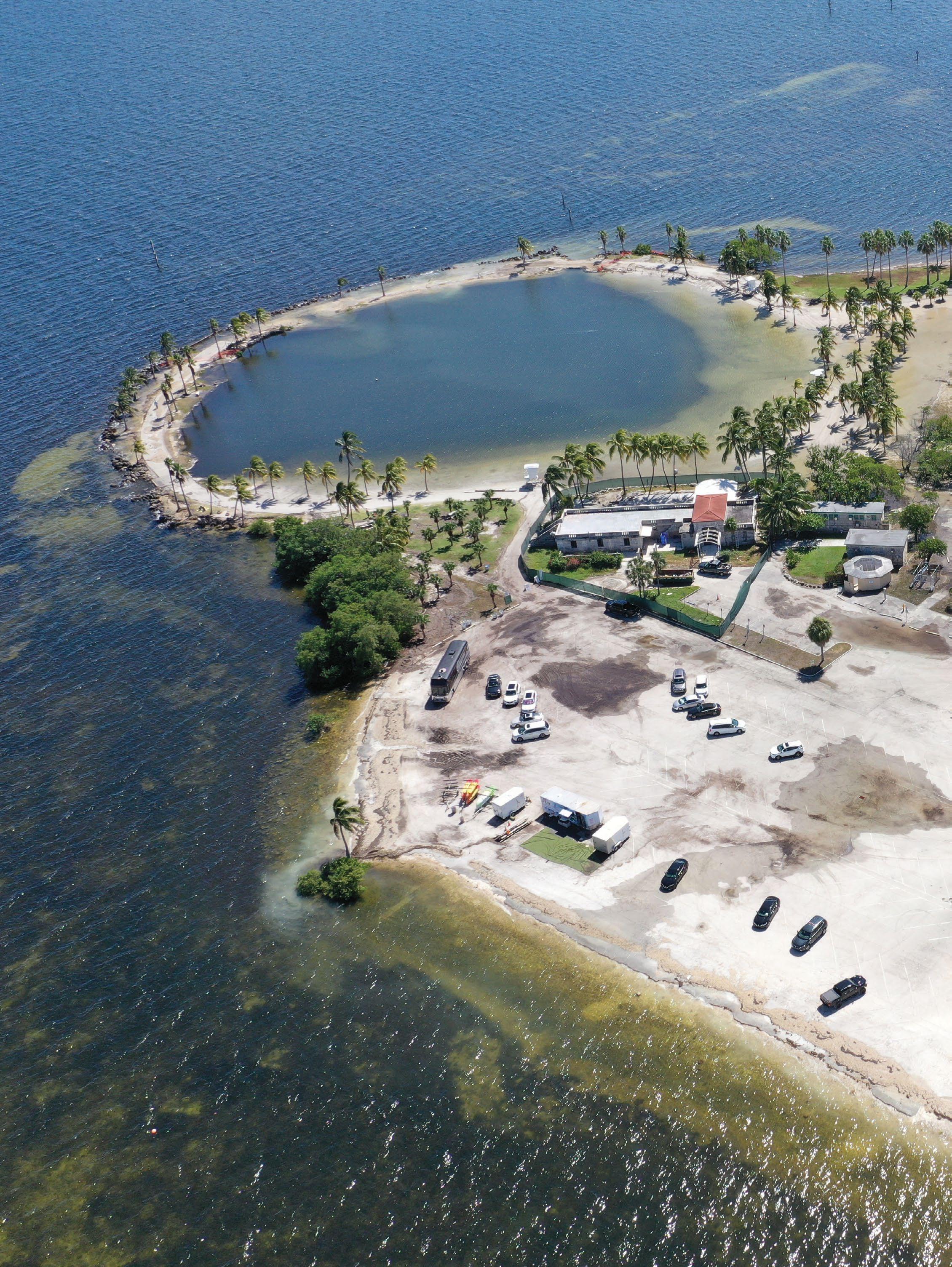
In early 2017, the Miami-Dade County Parks, Recreation & Open Spaces Department initiated resiliency planning of their waterfront parks. High tides and sea level rise were becoming a real threat and also impacting daily operations.
The need for resiliency planning was further emphasized by the impacts of Hurricane Irma later that year, which caused damage throughout Miami. Many of the parks include trails through mangroves, beaches, marinas, boat launches and waterside dining, and are also popular areas for kiteboarding, kayaking and paddleboarding.
Fronting the coastlines of Biscayne Bay and the Atlantic Ocean means these parks are relatively low lying, which results in flooding to some areas during high tide events. In addition to the negative impact on the visitor experience, flooding has financial impacts, as revenue generating components are impacted operationally and physically. If improvements were not implemented, parts of the parks – or even entire parks – would likely be unusable during a large portion of the year within the next 20 years.
As impacts from flood-related issues started receiving more attention, Miami-Dade County Parks relied on Cummins Cederberg, a leading South Florida based coastal and marine engineering firm, to recommend solutions. A study of the conditions was conducted relative to developing flood mitigation concepts and a longterm roadmap to limit impacts of sea level rise on seven of the County’s waterfront parks, totaling more than 2,000 acres.
“Our approach is unique and specific to protecting infrastructure assets in pragmatic and cost-effective manner,” said Cummins Cederberg Principal Jannek Cederberg. “By combining sea level rise projections, practical concepts and on-the-ground implementation experience with maintenance and replacement requirements relative to overall service life, we gave the county a clear roadmap relative to planning infrastructure improvements in the park until 2100.”
Building A Roadmap To Flood Mitigation
Incorporating flood mitigation measures can be costly if performed in an untimely manner or on an emergency basis. Additional costs of adapting to storm surge and sea level rise could be significantly reduced if incorporated incrementally into periodic maintenance or capital improvement events.
Many components are interrelated but might be earmarked for upgrades individually, which makes considering future improvements of related elements important. For this to occur, proper planning of improvements relative to water levels is required.
An assessment of existing infrastructure and environmental resources was conducted on all seven parks to understand and document current conditions. The condition of any existing infrastructure is important to determine remaining service life and potential repair options, as well as the feasibility for adaption relative to increased water levels.
In this case, Miami-Dade County parks lie within pristine natural areas, surrounded by environmental resources including mangrove forests and seagrass beds, which may provide constraints relative to potential flood mitigation concepts.
Tidal Values And Sea Level Rise
Published tidal elevations are average values and are exceeded on a frequent basis. The predictions of tidal water levels show a periodically seasonal high-water level during a certain time of the year, popularly referred to as “king tides.” King tides cause flooding in inland, low-lying areas or when heavy rainfall events occur, as the drainage efficiency is decreased due to the elevated water levels.
An evaluation of typical and extreme tidal water levels was conducted to understand peak tidal levels and exceedance probability. The local tidal range in Miami is approximately 2.0 to 2.5 feet, depending on the time of the year. In addition to variations in the tidal levels, there is also variation between the predicted and the observed water level values because of wind, temperature, pressure and other factors, which can result in differences of up to 1.5 feet at each area.

Matheson Hammock Park, Miami-Dade, FL
The adopted sea level rise projections at the time forecasted an increase of 1.2 feet by 2050 and 4.4 feet in 2100 as compared to now. In 2050, these parks would see frequent flooding, and by 2100, entire parks would be flooded most of the time.
To further evaluate areas of flooding, a flood inundation analysis was performed to determine what areas are flooded at various increasing water levels, as well as the sequence of the flooding to identify critical areas that serve as access for other areas of the park. Topographic LiDAR data was compiled and processed in order to develop a detailed three-dimensional contour map of the project area.
The flood inundation modeling showed that, over time, new areas of the parks will be inundated if improvements are not implemented. By 2100, the model found entire parks will be flooded except for small portions due to regular Mean Higher High Water (MHHW) conditions. During extreme tide conditions and storm surge entire parks could be completely flooded.

Miami-Dade, FL - A flooded beach and roadway during a high tide event deters visitors and reduces revenue for on-site businesses.

Flood Mitigation Schedule And Concept Development
Based on the condition assessment, sea level rise projection and inundation modeling, flood mitigation concepts were developed. The urgency of implementation was determined based on remaining service life and current flood exposure. An implementation schedule was developed based on resiliency and service life, marine resource impacts, environmental permit feasibility, maintenance requirements and potential phasing.
The implementation schedule provides information relative to when replacement of a component is required based on the service and the recommended design elevation at each replacement stage.
“Not only does this allow for planning individual components relative to each other, but it provides recommended elevations for adjacent components so proper transition can be planned and clearly depict when new projects should be implemented so our financial budgets can be prepared accordingly,” said Joe Cornely, assistant director for Miami-Dade County Parks.
Resilient Infrastructure
Today, Miami-Dade County is well into the design, permitting and construction of Cummins Cederberg’s recommended implementation schedule, including upgrades to parking lots, boardwalks, shoreline stabilization, and improvements to boat launches.
Identifying the need to incorporate solutions against storm surge and flooding is the first step of an actionable plan. More importantly is the implementation schedule.
Proper planning and implementation scheduling, combined with routine maintenance on infrastructure projects, will build cost-effective resilient futures for waterfront facilities.