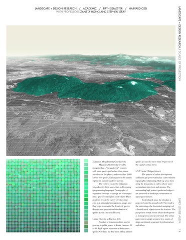
MVV Aerial Oblique (above). The pattern of urban development and landscape preservation has a deterministic topographic relationship. Built up areas form along the low points, in valleys where water accumulates into rivers and streams. The surrounding high points—peaks and ridges— are preserved as landscape conservation or open space features. In developed areas, the site plan is projected onto the ground itself. The result is the patterning—the horizontal stamping—of a limited set of objects across the horizon. The perspective reveals recent urban development as homogeneous and acontextual. The urban pattern increasingly seems to be a matrix of single-use islands, separated by infrastructure and offsets.
14
Urban Diversity as Fraction (left). Number of documented tree species growing in public spaces in Kuala Lumpur: 20 to 30. Each square represents a distinct tree species. Of these, the four most widely planted
species account for more than 70 percent of the capital’s urban forest.
EMILY LOUISE ALLEN
Malaysian Megadiversity Grid (far left). Malaysia’s biodiversity is widely recognized as a “mega-diverse” country, with more species per hectare than almost anywhere on the planet, and more than 2,000 known tree species. Each square in this matrix represents an individual tree species. The code to create the Malaysian Megadiversity Grid was written in Processing (programming language). Photographs of vegetation coverage or canopy are rearranged into a grid of sorted pixel color values. These gradients reveal the variety of values that exist in a seemingly homogeneous image, and they begin to speak to the density of species diversity and proportional distribution of species across a measurable area.
LANDSCAPE + DESIGN RESEARCH / SCALES OF PROJECTION
LANDSCAPE + DESIGN RESEARCH / ACADEMIC / FIFTH SEMESTER / HARVARD GSD WITH PROFESSORS ZANETA HONG AND STEPHEN GRAY