5 minute read
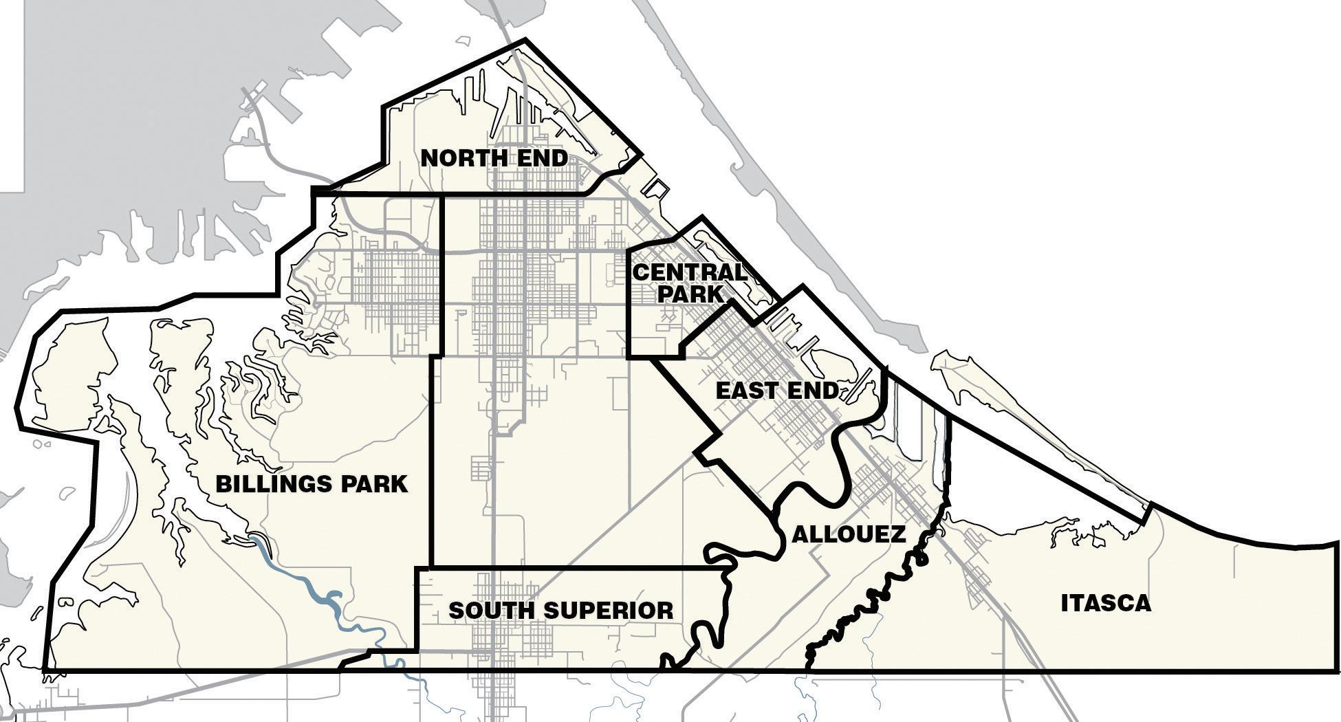
Neighborhoods shape Superior


By Shelley Nelson snelson@superiortelegram.com
Superior’s oldest neighborhoods reflect how the city developed since it was settled in the early 1850s.
The city’s oldest neighborhoods are found along the Superior Bay, accessible from Lake Superior through the Superior Entry, and by foot along the Old Military Road that was never completed.
When Superior experienced its second economic boom around 1888, neighborhoods developed in what was called West Superior, giving the city, chartered in 1889, its triangular shape bounded on two sides by the Superior and Allouez bays, and St. Louis River.
East End
With the backing of Eastern financiers and investors, East End was the neighborhood where Superior began. The area north of the Nemadji River to 14th Avenue East was platted as the townsite of Superior in 1853, according to historian Paul Lusignan in his 1983 “Superior Intensive Survey Report.”
While sites along the Nemadji River marked some of the earliest sites claimed, it was the area from 25th to 19th Avenues East from East Sixth Street to the waterfront that developed most densely on 25- by 120-foot lots perpendicular to the waterfront.
The main commercial district was originally on East Second Street, an old Native American trail, but increasing industrialization of the waterfront and the coming of railroads in the 1880s forced the commercial district to move to its current location, East Fifth Street.
East End became a bustling community with churches, schools, parks, a library and the Euclid Hotel. It had the most developed and self-sufficient commercial district outside of the central business district on Tower Avenue, Lusignan wrote and news reports showed it own Chamber of Commerce, founded in 1883.
The port city’s first dock was built at the Quebec pier at 21st Avenue East in 1855. It later held a flour mill and grain storage complex built in 1893 by Edward P. Allis on the Quebec, Montreal and Detroit piers, according to Lusignan.
Central Park
In 1862, the townsite of Superior City — Central Park — was created from what is today Second to 13th Avenues East between East Ninth Street and the Superior Bay.
The speculative townsite, platted with 60- by 135foot lots, would never realize its dream of becoming a self-sufficient commercial community, but it would become a major residential area for the city, Lusignan said.
Up until 1890, development was limited, but the large lots, particularly along East Second, Fifth and Seventh streets became treasured for residential construction by affluent residents, Lusignan wrote. Many substantial residences were constructed in the 1890s and early 1900s, but the 20th century brought more moderately scaled homes to the neighborhood.
Allouez
Located southeast of the Nemadji River, Allouez was platted as part of the original Superior town site in 1853, but development of the area didn’t begin until the 1890s, when the Great Northern Ore Dock was constructed and large influxes of working-class families came to the area.
Early residential construction in the area consisted of small-framed homes and bungalows, which were built inexpensively and quickly for worker housing.
The area between Bluff Creek and the Nemadji River was a thriving community with its own churches, schools, stores, restaurants, barber shop, bowling alley, jail, bank and lumberyard. Itasca Street became the center of Allouez’s business district.
The Great Northern Ore Docks, Pittsburgh Coal Dock, Itasca Grain Elevator — all the largest in the world in their time — and the Great Northern Railroad sustained the community, providing jobs by the hundreds.
Itasca
The arrival of the Chicago, St. Paul, Minneapolis and Omaha Railway prompted the development of the Itasca neighborhood. In 1893, the railway established its repair shops and transfer yards between Bluff and Bear creeks, Lusignan stated.
Within a year, the new townsite of Itasca was platted and lots began to be sold. A commercial district consisting of two boarding houses, a grocery store and post office were established along East Third Street.
Like Allouez, the housing was simple.
The most dramatic change to impact the neighborhoods along Superior’s eastern waterfront, which made Itasca an entry-point to the city, was the completion of the interstate highway system. U.S. Highways 2/53 resulted in the rapid commercial strip development along East Second Street.
Continued on page 50
North End
When Superior’s development moved west, the earliest neighborhood to develop was north of the rail lines that parallel Winter Street during settlement of West Superior.
North End grew around the working waterfront — coal docks and shipbuilding — and Northern Brewery and the neighborhood offered taverns and hospitality to serve the shipping industry, said Andy Lisak, who grew up in North End.
North End developed a reputation for being the bad part of town; it was where the city’s red light district, developed along North Third Street. Superior had 21 of the 48 brothels in Wisconsin discovered by undercover detectives in the winter of 1913-1914 for the Teasdale Vice Report, according to the Wisconsin Historical Society.
The once tightly packed neighborhood was often the first home for new arrivals to the city and was a strong working-class area for new ethnic or racial groups, Lusignan said. The neighborhood once had a significant Orthodox Jewish community and two synagogues so people could walk there, said Sam Pomush of North End; his father, an Orthodox Jew, ran the city’s first junkyard in North End. Pomush estimated about 300 Jewish families were sprinkled throughout the North End, which had a peak population of about 12,500 in 1910.
Billings Park
Superior’s westernmost neighborhood was once called Steel Plant because the neighborhood owed its early development to the West Superior Iron and Steel Company, located on a plateau facing the St. Louis River, according to Norris Dickey, who compiled a history of Billings Park for the Superior Public Library in 1941.
The plant, built by New York financier James Roosevelt in 1888, went into operation in 1889, which prompted a flurry of building as blue-collar workers sought living arrangements within walking distance. Originally, the neighborhood extended from North 18th to Belknap Street between Maryland and New York avenues, Lusignan wrote.
By 1899, the steel plant was sold to interests in the East and ceased operation entirely by the mid-1910s. The neighborhood later took on the name Billings Park, so named after businessman Frederick Billings donated land to the city along the St. Louis River. The neighborhood grew outward with the extension of the streetcar, Lusignan stated.
A commercial district developed along Iowa
Avenue, and at one time, Billings Park had seven grocery stores — there are none today — a golf course, the elite Gitchinadji Club, an airport, and the Arrowhead Bridge to connect to West Duluth, according to Dennis Dalbec, who grew up in the neighborhood in the 1950s and 1960s and still lives there today. He said his family still lives within about six blocks of him.
South Superior
The South Superior Improvement Company purchased large tracts of land south of the main area of the city, between North 52nd and North 64th streets, in 1889 in hopes of establishing a major manufacturing center. Directors J.F. Merriam, John Nicholson and J. Harper secured Labelle Wagon Works Company, Webster Chair Manufacturing Company, Superior Malleable Iron Works, GoodmanWilcox Sash and Door and other firms, as well as creating a residential community and developing a commercial district along Tower Avenue, according to Lusignan. The neighborhood had its own schools, fire station, bank, railroad station, churches and two hotels, and tied to the rest of the city by a creosote brick road before the arrival of the first streetcar. Councilor Dan Olson, who has lived in South Superior his whole life, said the neighborhood remains a relatively cohesive one where neighbors look out for one another and families tend to stay once they’ve moved there.