

JUNE 2024 SURVEYING AND MAPPING, ELEVATED SURVEYING GIS HYDRO SCANNING 26 Protecting the Shoreline INSIDE MAPPS Liaison Program 22 Water from the Cloud 12
 By Jeff Thoreson
By Jeff Thoreson



Geosciences and geospatial professionals
The National Oceanic and Atmospheric Administration and MAPPS maintain a federal agency liaison program to help member organizations with NOAA programs, contracts, and ongoing collaboration.

Thanks to laser scanning, the new Seattle Aquarium provides visitors with one of the greatest sea life experiences in the world.
Protecting both legacy and green off-shore energy facilities with new geospatial technologies is becoming critical.
These industry experts from a wide range of geospatial firms help guide the editorial content you have come to expect from xyHt Magazine.


TYPICALLY
As an industry we help plan for and react to floods, wildfires, hurricanes, tornadoes, and other forms of Mother Nature’s will that wreak havoc on life in a particular place. Although often in a different role, we are called upon when manmade disasters happen.
Almost 25 years ago our industry was key to building One World Trade Center, and now we will be a key element in rebuilding the Francis Scott Key Bridge near Baltimore. From land surveyors who will make highly accurate measurements to make sure the new bridge follows a precise route to those who will monitor the remote sensors on the finished superstructure and fly the drones for periodic inspections, geospatialists will play a vital role in Baltimore over the next few years.
Writer Juan B. Plaza takes a look at the intricacies of this lengthy process in his story “Rebuilding in Baltimore” that starts on page 16.
From working on the water to working with water, Marc Delgado looks at how water utility companies are getting “Water from the Cloud.” As water becomes a more precious resource, utilities are using geospatial cloud computing to map their infrastructure, streamline workflows, and enhance their customers’ experience. Does this cloud have a silver lining?
As our shoreline and ocean water becomes more important from a geospatial perspective, it is also becoming important from a security standpoint. Contributor George Gladorisi takes a look at new technologies that will help keep our offshore energy sources safe. And one final article involving water, but more involving laser scanning, contributor Mack Kowalski looks at how acrylic panels in the new Seattle aquarium were precision-fit to give visitors a spectacular view of aquatic life.
I hope you enjoy the issue.
Publisher Shawn Dewees shawn.dewees@xyht.com
Editor-in-Chief Jeff Thoreson jeff.thoreson@xyht.com
Director of Sales and Business Development Chuck Boteler chuck.boteler@xyht.com
Creative Director Ian Sager ian.sager@xyht.com
Accounting and Classifieds Angie Duman angie.duman@xyht.com
Circulation subscriptions@xyht.com Phone: 301-662-8171
Editor, Located Jeff Salmon jeff.salmon@xyht.com
Editor, Field Notes Eric Gladhill eric.gladhill@xyht.com
Contributing Writers Marc Delgado George Galdorisi Mack Kowalski Juan B. Plaza Mark Safron
Affiliates





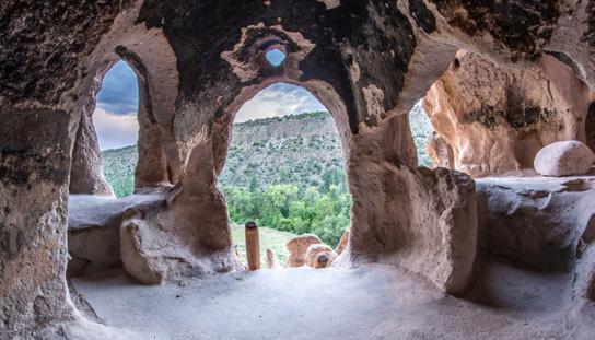
ALMOST A MILLENNIA AGO, THE PUEBLO PEOPLE INHABITED AN AREA OF NEW MEXICO near the banks of the Rio Grande. There, they found soft volcanic tuff ideal for carving out homes, storehouses, and communal spaces in large villages that spanned miles. These carved architectural structures, or “cavate dwellings” were cool in the summer and warmed by easterly light in the winter—a type of natural, sustainable architecture.


Two graduate students, Gracie Meek and Jialei Tang from the Harvard Graduate School of Design, are capturing the past with new geospatial digital tools. Their recent project at the Bandelier National Monument is a remarkable intersection of cultural heritage and cutting-edge technology.
Meek and Tang used Leica Geosystems’ BLK360 to create detailed digital models of the cave structures and cliff dwellings while working with the National Park Service to complete the project. The result is a first-of-itskind digital model that preserves these ancient marvels and creates new possibilities for visitors to experience the park in the virtual world.
The pair started out scanning the Long House, an 800-foot-long serpentine run of cliff dwellings up to four stories tall. It took them about three days to scan the complete structure, with setups every 10 to 15 feet, and the dodging of the occasional thunderstorm.
“We weren't expecting issues with thunderstorms because it wasn’t monsoon season yet,” Meek said. “So, we had to be ready to go up to the threshold of the clouds and then take a gamble. When we were talking to the rangers at Bandelier, they asked us to make one for them for their visitor center, because it provides a novel and comprehensive perspective of the entire cliff dwelling system for the visitors to interact with,” Meek said. “We're really excited about that.”

SENTINEL-1A, THE EUROPEAN RADAR IMAGING SATELLITE, is celebrating a decade of scientific and peaceful use of radar technology. Launched in April 2014, the Sentinel-1A has set a new standard for earth observation applications by providing useful radar images with its C-band syntheticaperture radar (SAR) instrument.
Unlike optical-based remote sensing satellites that rely on sunlight (Landsat, Ikonos, etc.), SAR payloads emit active long-wavelength energy that can penetrate through clouds, allowing Sentinel-1A to capture images of the earth’s surface in all weather conditions, both day and night. With a spatial resolution of five-meters and a swath of up to 410-kilometers, the Sentinel-1A satellite has been supporting both marine operations (tracking shipping lanes, sea ice, icebergs, and oil spills)

and land-based projects (agriculture, forest management, disaster response).
Because radar can provide millimeter-level information that is useful for ground motion analysis, Sentinel-1A images are now being used in the construction sector to measure the heights of buildings, monitor land deformations, and assess the impact of geo-hazards on civil engineering structures such as roads, dams, and bridges.
For a satellite originally designed to work alongside a twin-constellation (Sentinel-1B was retired in 2020 due to electrical failure) and now operating beyond its life expectancy of seven years, the Sentinel-1A will surely leave a lasting legacy to geospatial science and industry.
— Marc Delgado, marc.delgado@xyht.com
A NEW REPORT BY MARKETS AND MARKETS, cumbersomely entitled "Building Information Modeling Market by Offering (Software, Services), Deployment (Cloud, On-Premise), Project Lifecycle (Preconstruction), Application (Buildings, Industrial), End User (AEC Professionals) and Region—Global Forecast to 2028" offers insight into the BIM sector.
According to the article, the global building information modeling market was valued at $7.9 billion in 2023 and is projected to reach $15 billion by 2028. It is expected to register a compound annual growth rate of 13.7 percent during the forecast period. The rise in demand for BIM solutions is attributed to growing use of BIM as it leads to sustainable development and rapid rise in urbanization globally.
THE NEW DA62 MPP SURVEYSTAR HAS BEEN DELIVERED by Diamond Aircraft Austria to RIEGL Laser Measurement Systems and it will be immediately implemented for test and calibration flights.
RIEGL and Diamond Aircraft Austria have been collaborating for almost 20 years. Since 2007, RIEGL has owned and operated the proven DA42 MPP GeoStar, which has successfully completed all missions to date. The increased requirements in recent years have now made it necessary to "upgrade" to the new DA62 MPP SurveyStar.
The new DA62 MPP SurveyStar involved close collaboration between RIEGL and Diamond Aircraft to professionally integrate and efficiently utilize the entire
RIEGL sensor and system portfolio.
The DA62 MPP is the latest variant of Diamond Aircraft’s successful Special Mission Aircraft portfolio. The all-carbon-fiber, twin-engine aircraft is equipped with a state-of-the-art glass cockpit and a fully integrated autopilot. The carbon fiber material provides for unlimited airframe life and is not subject to corrosion, even when operated in saline and humid environments.
It is powered by two turbo charged jet-fuel engines with superb fuel efficiency. Together, fuel efficiency and unlimited airframe life combine for extremely low direct operating costs, making the DA62 MPP the most cost-efficient Special Mission Aircraft in its class.

GATWICK AIRPORT, THE UNITED KINGDOM’S GO-TO RUNWAY AFTER HEATHROW, is now using a new geospatial platform to support the aerodrome’s engineering and environmental services. The novel mapping system is making engineering and construction works in the airport safer by reducing accidental damages on buried utilities, as well as helping manage the biodiversity of plants and animals that live in the airport zone.
Based on Esri’s GIS technology, the mapping platform contains critical infrastructure information to support better collaboration and decision-making in the airport’s daily operations. It also supports Gatwick Airport’s Biodiversity Action Plan to manage 75 hectares of its surrounding woodlands, grasslands, and wetlands while also mapping the estimated embodied carbon of the airport’s built assets.
Other airports that have implemented their own GIS platforms include Geneva, Switzerland, Dublin, Ireland, and Atlanta’s Hartsfield International Airport. Geneva airport, for example, uses GIS to map in real-time its operations, including the different locations of the airplanes, while both Dublin and Atlanta airports leverage GIS to support safety via spatial analytics.
In the U.S., the Federal Aviation Administration updated last year its Airports Geographic Information Systems (AGIS) Survey Program to provide guidance on how to correctly map and survey airport layout and master plans. Next time you had a good layover in these airports, you have GIS to thank.
— Marc Delgado, marc.delgado@xyht.comTHE LEICA DS2000 UTILITY DETECTION RADAR FINDS ALL POTENTIAL
THREATS, including non-conductive pipes and fiber optics, increasing safety by lowering the risk of accidently hitting underground assets.
The unit allows operators to increase safety, speed up work, and lower asset management costs with the ability to prevent hazardous outages and collect more information.
Combined with the powerful and rugged Leica CT1000 field tablet, the GG04 plus or the GPS60 smart antenna, and the DD SMART Series cable
GeoBusiness
June 5-6
London, England
FOSS4G Europe 2024
July 1-7
Tartu, Estonia

Esri User Conference
July 15-19
San Diego, CA
MAPPS Summer Conference
July 28-31
Park City, UT
Intergeo
September 24-26
Stuttgart, Germany
Commercial UAV Expo
September 3-5
Las Vegas, NV

GoGeomatics Expo 2024
October 28-30
Calgary, Canada
Trimble Dimensions
November 11-13
Las Vegas, NV
Amsterdam Drone Week &
Commercial UAV Expo
April 8-10, 2025
Amsterdam, Netherlands
locators and transmitters, the DS2000 is part of the complete Leica Geosystems detection and underground mapping solution that will enhance your business by making it faster and more efficient. With IQMaps post-processing software, users will be able to perform advanced data analysis and convert radar data to CAD file.


TRIMBLE MOBILE MANAGER (TMM), A CONFIGURATION APPLICATION for Trimble GNSS receivers, has been overhauled and now boasts an easier-to-use, more efficient and more attractive user experience.
The release for version 4 introduces a completely new user interface developed from the ground up, providing a more intuitive and consistent user experience in a modern app.
In addition to the revised user interface, the new TMM introduces valuable new fea tures, including support for specifying antenna height, automatic connection to the last used receiver and an improved NTRIP setup and validation workflow.
The redesign of the TMM application is centered around making it easier to use on a dayto-day basis, putting the most used functions a single click away from the home screen. The number of clicks to achieve an action has also been reduced where possible.
THE EUROPEAN SPACE AGENCY (ESA) HAS RECENTLY LAUNCHED two new satellite missions which aim to put Europe ahead of the satellite navigation race. The new missions, called GENESIS and LEO-PNT, will apply European expertise in satellite navigation as well as in Positioning, Navigation and Timing (PNT) technologies.
The GENESIS satellite will employ the latest technologies used for earth geodetic measurement to map the contours of the earth down to the scale of a single millimeter, effectively enhancing the accuracy of our terrestrial reference system and improving the proper georeferencing of all geospatial information.
The LEO-PNT mission, on the other hand, will employ a constellation of satellites that will fly at low orbits (less than 2,000 km).
Using novel signals and frequency bands, the LEO-PNT satellites will provide exceptional accuracy to existing GNSS and will be useful in places where current satnav systems cannot penetrate, including streets between tall skyscrapers as well as indoors. Both missions, costing €233 million ($249 million), are part of ESA’s FutureNAV program, which aims to modernize Galileo, Europe's global navigation satellite system.
“With Genesis and LEO-PNT we are responding to rapidly growing needs for more resilient and precise navigation”, said Javier Benedicto, ESA director of navigation. Genesis will be launched in 2028, while LEO-PNT will be in orbit by 2027. — Marc Delgado, marc.delgado@xyht.com

VIRTUAL SURVEYOR HAS ENHANCED ITS POPULAR SMART DRONE SURVEYING SOFTWARE with new planimetric survey capabilities. In addition to multiple performance modifications, Virtual Surveyor version 9.5 now enables users to quickly, easily, and accurately survey 2D features from drone orthophotos and add them to the 3D topographic model generated from the same data set.
True 2D features, for example, include the recognizing paint striping that delineates parking lot spaces and road lanes. Other objects that exist in 3D on the ground but can be surveyed in two dimensions for many applications are building footprints and tree canopies. The addition of these features brings a new level of efficiency to the drone surveying process in Virtual Surveyor.
Virtual Surveyor provides users an end-to-end workflow to conduct 3D surveys from drone imagery. The integrated Terrain Creator app photogrammetrically processes drone photos to build survey-grade digital surface models (DSMs) and orthomosaics. These transfer seamlessly to the traditional Virtual Surveyor app where users perform the real survey work—generating CAD models, creating cutand-fill maps, calculating soil volumes, and deriving other 3D topographic information.


THE 43RD EDITION OF THE ESRI USER CONFERENCE CONCLUDED SUCCESSFULLY in July with more than 18,000 GIS enthusiasts attending the talks and sessions in San Diego, California. As one of the world’s most important mapping events, the Esri conference typically focuses on a wide range of cutting-edge GIS topics. Yet this year’s sessions on artificial intelligence (AI), earth observation imagery, and digital twins created a lot more buzz. Mapmakers seem to be even more eager to grasp how this trio of innovative technologies will change the way maps will be created in the near future.
The conference was also a launchpad for several companies, such as Bad Elf, Maxar, and Trimble to showcase their latest mapping products and services. Likewise, Esri released its most recent global land-use/land-cover map, which has been revamped using, what else, AI technology.
“We are constantly updating our land-cover map with new data and features, and this latest improvement ensures that anyone viewing temporal change can be confident what they are seeing represents the natural world,” said Sean Breyer, Esri program manager for ArcGIS Living Atlas of the World.
— Marc Delgado, marc.delgado@xyht.com
THE R180 IS A HIGHLY ACCURATE AND FAST Android robotic station. It features a rotation speed of 180°/sec and an EDM accuracy of 1 mm + 1 ppm, with a range of up to 1,000 meters without a prism. The R180 is available in two versions, 0.5″ and 1″ second. For both models, the quietness and smoothness in prism searches and rotations are among the most observed and appreciated features.
Equipped with the Android operating system, the R180 has Cube-a as onboard software. This enables users to navigate online and interact with the touch screen in an easy and familiar way.
The Cube-a onboard software includes all the classic functions of the program, as well as the integration of jobs done with GNSS, and surveys done with the total station. This allows operators to achieve complex and professional work in a short time and with high accuracy. Additionally, the R180 has a camera and a light guide to further facilitate fieldwork.


Water utility companies are tapping into geospatial cloud computing to map their infrastructure, streamline workflows, and enhance customer services
By Marc M. Delgado, PhD
Clouds are important to the Earth’s water cycle. By gathering vapor from one region and then dropping it as rain in another, they serve as the main conduits to move water across the Earth’s surface. So, when one of the largest water and wastewater services companies in the U.S. says that it has headed to the cloud, you might be excused for the mix-up.
The cloud that the Great Lakes Water Authority (GLWA) refers to is “cloud computing” or the delivery of digital services, from data storage to software and analytics, over the Internet.
GLWA is using cloud computing not only to help it maintain the potability of the water that it provides to 40 percent of Michigan’s population (roughly 3.8 million people), but also to make it possible to deliver wastewater services to nearly 30 percent of the region. As the largest state east of the Mississippi River, water demand in Michigan is driven mostly by domestic use, industry,
fisheries, and agriculture. Managing such a huge area can be difficult, especially when (GLWA) has to regularly inspect the quality of the water bodies.
Before GLWA migrated to the cloud, monitoring teams had to visit and draw test samples from various sites covering some 1,698 square-mile of service area. Then after that, they had to manually input the water quality data into unconnected computer systems. It could take six months to a year to be able to share their reports to their partner communities.
But in 2020, GLWA rolled out AURA, a digital program that their partner communities can use to automate their water quality monitoring activities, which gives them access to water and wastewater maps, all free.
Developed by the company Aquasight, and deployed using the cloud-based Amazon Web Services (AWS), AURA provides a

smart water platform which allows all of GLWA’s member communities to view various water quality parameters in real-time using computer dashboards and mobile devices that are linked to the Internet.
“Receiving information faster makes it more actionable and means member partners can respond to potential issues before water quality is impacted,” said Terry Daniel, deputy chief operating officer of water and field services at GLWA. “This has reduced our reporting time from months to the same day and has enabled us to reallocate team members to new work.”
Another feature AURA offers is the possibility to add their own GIS maps and other smart meter data in order to improve their own waterworks asset management plans. There is also plenty of spare space to accommodate more data because AURA utilizes the online scalability of AWS, which adapts to different levels of computing workloads.
The system uses Amazon Simple Storage Service (Amazon S3) to store visual assets such as GIS maps, HTML/CSS files, JavaScript resources, and raw data including logs, documents, images, or other unstructured data.
“We can accommodate growing data storage needs without worrying about capacity limitations,” said David Inman, the onboarding manager at Aquasight.
“We’re able to build applications on this flexible framework and quickly scale to needed capacity.”
AURA is just one of the many examples that show how cloud computing is transforming the way geospatial data is collected and analyzed for the benefit of water utilities. Esri, one of the world’s biggest GIS companies, has taken notice

of the trend and has now developed its own geospatial cloud strategy, which aims to provide quick integration and analysis of large geo-datasets and imagery from city to regional or even global levels.
For example, Esri has been working with Loudoun Water so that the community-owned water utility company based in Virginia can implement its standalone enterprise software and link it with Esri’s own GIS mapping functionalities. While Loudoun Water uses GIS to keep a geodatabase of all its waterworks assets (pipes, maintenance holes, hydrants), it also links all the mapped data with the SAP software in order to harmonize all the maintenance and engineering operations in the field.
In fact, Loudoun Water is one of the first water utility companies to integrate GIS mapping with the SAP asset and maintenance management software. And later on, when the company implemented its cloud-first policy for technology, Loudoun Water was able to migrate all of its geospatial and SAP solutions to Microsoft’s Azure, another cloud service provider.
Their pioneering work has been recognized by Esri as a model for other waterworks providers who are building their own smart mapping solutions. They won Esri’s Special Achievement in GIS award in 2017 and another special GIS award during the previous year.
“I’ve been watching Loudoun County
for a long time through the evolution of their technology,” said Jack Dangermond, founder and president of Esri, in a separate interview with Geospatial World “Loudoun not only continues paving the way in open data but serves as an example for how governments of all sizes can engage the public and become smart communities.”
The success of Loudoun Water in geospatial cloud computing may be partly because it is at the right place at the right time. Loudoun County is located in the cloud capital of the world, where roughly 70 percent of the world’s Internet traffic goes through one of the more than one hundred data centers located there.
“The cloud is based somewhere and, by and large, the cloud has been based here in Loudoun County, Virginia, in the 18 million-square-feet of data centers that we have on the ground here,” said Buddy Rizer, executive director of economic development for Loudoun County, in an interview with VOA. Other cloud computing powerhouses with data centers that operate in the Loudoun area are Amazon and Google.
While Loudoun uses cloud computing to monitor its water assets, other water utility companies are tapping the cloud to improve how they engage with their customers.
Take for instance South East Water, a company that supplies 521 million liters
of drinking water per day to 2.2 million people in the southeast part of England. Its specially designed digital application called “My Account” allows its customers to directly manage their own accounts online via their smartphones or personal computers. With “My Account,” customers can track their household water use and pay their water bills, while also helping them report water leaks and detect water outages using an interactive online map.
All this is made possible by Google Cloud Platform (GCP), the suite of cloud computing services offered by Google’s parent company Alphabet. South East Water chose the cloud platform to create the “My Account” application and support its customer-facing portal.
“We listen to our customers’ feedback to match our services to their expectations. Google Cloud gives us everything we need to build an app that empowers us to act on that feedback quickly and cost-effectively,” said Richard Bannister, business services systems manager at South East Water.
Thousands of customers have signed up since the application’s release in 2021.
“We’ve had hundreds of thousands of transactions going through the “My Account” application, and that can be people getting their balance or making a payment,” said Tanya Sephton, customer services director at South East Water. “For example, 25,000 people have used it just to update their payment details, instead of calling our contact center.”

The application makes South East Water’s services more accessible to its customers. Before migrating to the cloud, it used to take days to receive and validate one customer request. Now it only takes 30 seconds. And with the time gained, customer service agents can focus more on talking to customers who call for assistance.
“We’re always looking for innovative ways to help and support our customers,” said Sephton. “And having established our new development environment on Google Cloud, we can explore new tools for pushing the boundaries of how we interact with them as a utility company.”
Deploying to the cloud all the geospatial needs and capabilities of companies brings about several benefits. First, cloud platforms are engineered to scale whatever computing resources are available. This means that bandwidth, storage, and memory can all be pooled together and their usage can be dynamically adjusted proportionate to user demand.
Such elasticity allows the cloud to use more virtual computing machines and storage when the platform has more traffic. But it can also return to fewer or even a single machine and use little memory when the traffic returns to normal.
Second, geospatial cloud computing makes it possible for users to tap into multiple mapping databases. Vector maps, satellite and aerial imagery, weather data,
and digital elevation models, for example, could come from different web repositories. And with the use of cloud-based application programming interfaces (API), users can automate complicated workflows and call various geodatabases as they see fit.
With SaaS, customers hardly need to install anything on their computers or write code on their screens. The service also allows businesses to save up on costs by eliminating the need to purchase mapping software and hardware storage

Migrating to geospatial cloud computing makes it possible for users to access geospatial applications via SaaS or Software-as-a-Service platforms. Several GIS applications such as ArcGISOnline, CartoDB, Mapbox, and Rstudio follow the SaaS-model to provide hundreds of on-demand spatial analysis and visualization functions to their customers.

peripherals. Because companies only pay for the IT resources that they use, SaaS has become a more cost-effective alternative to traditional GIS desktop mapping.
Yet despite all these benefits, migrating to the cloud can be daunting to businesses. Many geospatial professionals are hesitant to work in the cloud due to their lack of skills. Also, the high price of cloud services can be expensive for smaller companies. What’s more, concerns about data security remain valid because cloud services are still prone to outages caused by fire, water damage, and cyberattacks.
As a result, global spending last year on cloud computing declined after a decade of growth. As not every cloud has a silver lining, water utility companies should be aware of these issues before they move their geospatial activities to virtual space. ■
Marc Delgado, PhD, is a GIS specialist who crisscrosses continents teaching GIS in Asia, Europe, South America, and Africa. Thanks to cloud-computing, customers can map the location of floods and other water problems in real-time using mobile phones.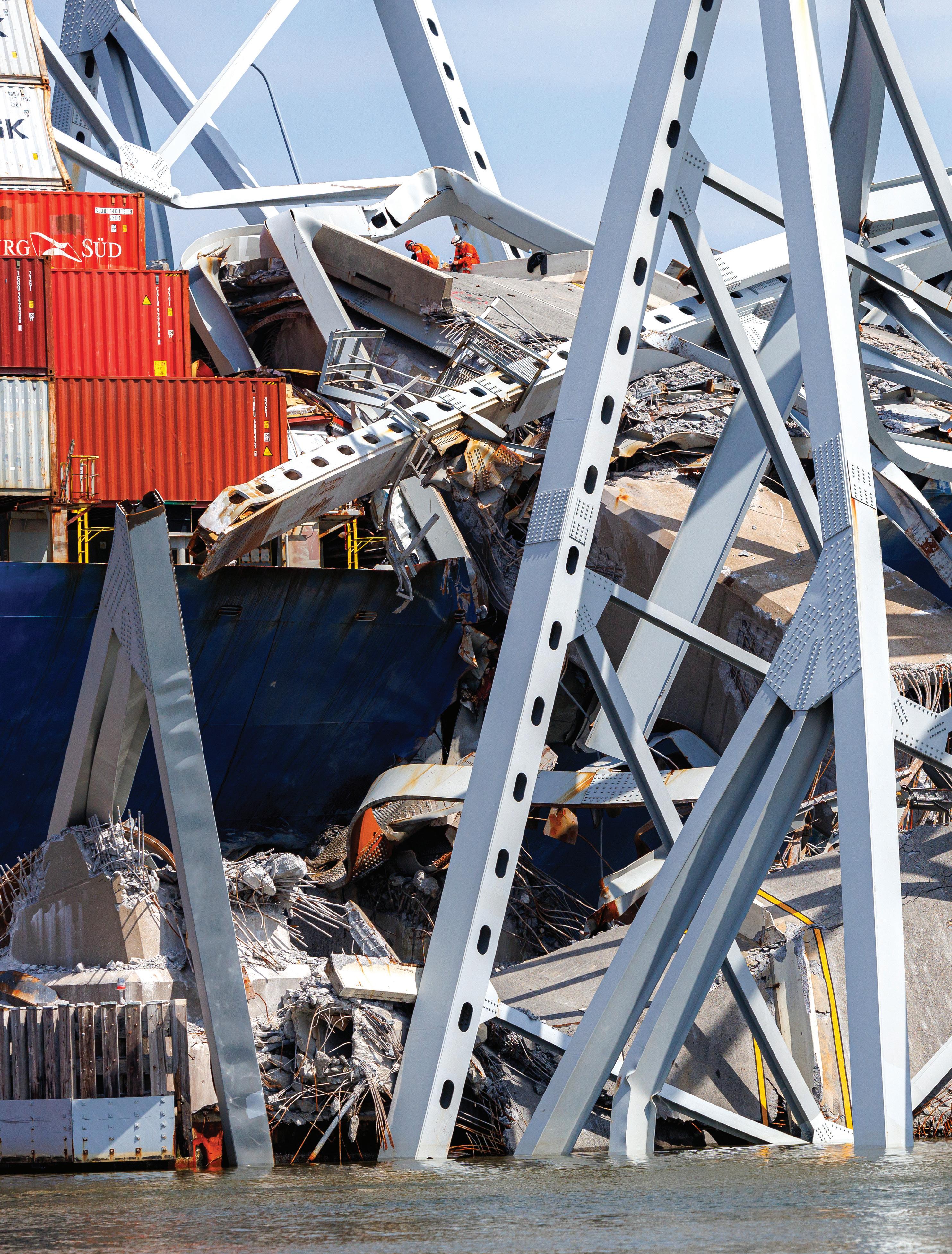
Surveyors and geospatial professionals will play a key role in rebuilding Baltimore’s Francis Scott Key Bridge
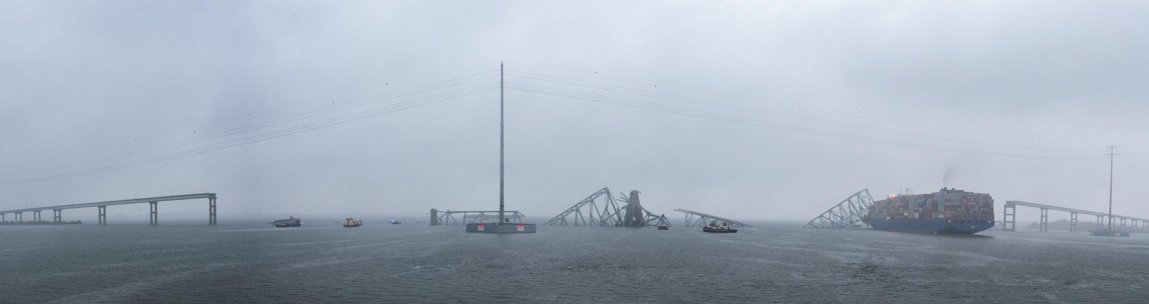
By Juan B. Plaza The superstructure of the collapsed Francis Scott Key Bridge rests on the container ship Dali.
It has been said many times that land surveyors are the first to arrive at any construction site and the last to leave. This old adage is ever truer in the case of bridge construction where precision and alignment can be the difference between success and failure. This accuracy can only be obtained by using precise instruments and a rigid methodology. Land surveyors and geodesists excel at this.
In the recent disaster involving a container ship hitting and demolishing the Francis Scott Key Bridge in Baltimore, Maryland, we can easily predict that our profession will play a key role in the analysis of what is left of the structure and the eventual replacement of the bridge.
Construction on the Francis Scott Key Bridge began in 1972 and it opened on March 23, 1977. Its construction completed Interstate 695, which is the beltway around Baltimore. The Key Bridge carried 12.5 million vehicles in 2023, averaging more than 34,000 vehicles a day. It spanned the Patapsco River, the only shipping channel in and out of the Port of Baltimore, which is among the top 20 ports in the United States by tonnage and number of containers handled. Baltimore is 10th largest port for dry bulk and the largest import/export port in the U.S. for cars and light trucks.
We reached out to some land surveying companies in the Baltimore area and all of them agreed that it was too early to engage land surveyors in the process and none of them have been contacted yet. They are all in agreement that the new bridge will be a considerable upgrade to the old one. They expect the new structure to be wider, to accommodate more vehicular traffic between riverbanks and to be taller to increase the tonnage available to the port.
Some of these professionals in the Baltimore area also believe that by upgrading the bridge, the port will be more competitive to nearby ports and that would force the authorities to, simultaneously, upgrade the port itself, creating more work for land surveyors.
So, we can safely assume that the bridge will be replaced urgently, so let us analyze the different areas of geospatial sciences that will be involved in the process.
Bathymetry: The most urgent issue was to re-open the channel to allow the Port of Baltimore to resume shipping activities. In order to do this, demolition companies had to locate and remove metal and concrete debris from the bottom of the channel. Once these operations have taken away the larger pieces, a detailed bathymetry survey was conducted before the first of the five ships stuck in the harbor after the collapse was allowed to leave on April 29.
3D Modeling: Once all the debris has been removed and the operation of the port is normalized, it would be time to replace the bridge. The big question at this point would be whether to replace the Francis Scott Key bridge with a similar structure or take the opportunity to upgrade to a wider model to accommodate for the increased traffic. Given that ships are wider, higher and heavier than in the 1970s, when the bridge was built, it is reasonable to assume that a wider and taller bridge will replace it. In any case, most of the


existing non-metal supporting structure will be analyzed for demolition and debris removal. Precision laser scanners will be used to create high-accuracy 3D models of each pilar to compare and evaluate soundness and plan demolition strategy.
Precision Mapping: Once all the debris has been removed it will be necessary to conduct a high-accuracy mapping effort of both sides of the river to analyze the potential sites for the abutments of the new structure. This highly accurate map will complement the bathymetry of the river floor in order to provide design architects and engineers with the necessary topo-

graphic information to design a new bridge.
Staking on Land: Once the design is ready it would be the time for land surveyors and geodesists to accurately locate the design anchor points both on the riverbanks and underwater. This will require the use of microgeodesy, in some cases, due to the strict requirements of prefabricated metal structures that need to fall in place within 1/16 of an inch into fittings that have been installed into concrete foundations. This is one of the most crucial and precise events in any construction involving large metal assemblies.

Staking on Water: It
is safe to assume that the new bridge will have at least two foundations under water given the distance between riverbanks. Already the Francis Scott Key Bridge had a main span of 1,200 feet (366 meters) and was the third-longest of any continuous truss in the world. That means that engineers will try to replicate or, given the advancement of new materials and construction technologies, even stretch a little bit of the distance to accommodate more fluvial traffic. This will mean locating and marking these underwater structures with great accuracy and that would require surveying techniques.
With the introduction of inexpensive drones and highly accurate processing software, the sub-industry of construction monitoring has exploded into a must-have for any large building site and this reconstruction endeavor will be one of the largest building sites in the world for years. Drones will fly the entire span of the design at


least once a week and the results will be downloaded into building information modeling (BIM) software that would create statistics that, in turn, would help architects and engineers plan a better construction strategy.
Once the bridge has been finished, there will be a final flight of the mapping drone and a deep laser scan of every nook and cranny of the structure, both on the ground (girders, abutments, etc.) to create a digital twin of the bridge.
During the final stages of construction, high precision GNSS antennas will be placed in strategic locations throughout the superstructure to create a deformation model that would allow maintenance engineers to follow, using the digital twin, the different areas of the bridge that are subject to twists and bends due to environmental and load conditions.
After construction is completed a strict schedule of inspections will be planned and executed periodically to make sure the various components are not deteriorating outside of the design parameters. Issues like rust and fissures are important in determining the longevity of any structure constantly exposed to water. Drones will be extensively used for this purpose and all the information will be loaded into the BIM for follow-up.
As we can see by this basic enumeration of positioning tasks, land surveyors, geodesists, and photogrammetrists will be deeply involved in the two or three years of construction and then over the life span of the bridge as constant monitoring of deformation parameters require adjustments to keep the structure safe.
The next few years will be an exciting time for the surveying community in the Baltimore area, given the enormous amount of work that this project and the potential upgrade of the port itself will bring to the area. ■
Juan B. Plaza is CEO of Plaza Aerospace, a drone and general aviation consulting firm specializing in modern uses for manned and unmanned aviation in mapping, lidar, and precision GNSS.


This is the second in a series of four articles that highlights the MAPPS Federal Agency Liaison Program with federal agency partners and specifically with the National Oceanic and Atmospheric Administration (NOAA) where MAPPS member firms have a strong interest in programs, contracts, and ongoing collaboration. By developing and continuing impactful relationships with federal agencies like NOAA, we seek to improve opportunities for MAPPS member firms and help our federal partners sustain and grow their programs, which ultimately benefit all Americans. The first in this series appeared in the Februabry issue and can be found on xyHt.com
The MAPPS Liaison Program, designed with member firms in mind, works to foster dialogue between the private sector and its government partners and offers opportunities to shape the discussion of issues and programs of interest to our industry. Through the program, we learn and understand what agencies’ funding priorities are, determine if they align with MAPPS’ interests, and educate stakeholders on the importance of these programs.
Our work to advocate on behalf of member firms helps shape public policy and supports legislative advocacy for the geospatial community. We also promote opportunities in the mapping community through involvement in their programs and contract opportunities.
As the MAPPS liaison with NOAA, my role is to partner, collaborate, support, coordinate, report, and communicate between NOAA and the MAPPS Liaison Coordinator, the MAPPS board, and MAPPS membership.
NOAA, which plays a key role in shaping policies for our nation’s oceans, fisheries, climate, space, and weather industries, is an obvious choice for the MAPPS Liaison Program. NOAA’s National Ocean Service (NOS) oversees most of the NOAA geospatial contracts that are of interest to the MAPPS community.
“Geospatial information is at the core of supporting NOAA’s mission. Geospatial technologies provide the framework to collect, store, analyze, and disseminate ‘NOAA’s Environmental Intelligence.’ NOAA is also the authoritative source for multiple national datasets that form the foundation for the National Spatial Data Infrastructure, to include geodetic control, nautical charts, coastal elevation, weather and climate models, critical habitat, and satellite and observational platforms.”
Read more at www.noaa.gov.
Three contracts of specific interest to our

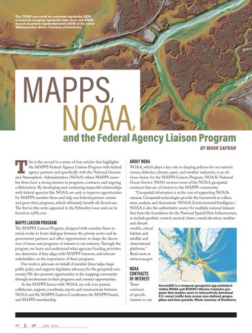
AccessAIS is a temporal geospatial app published within NOAA and BOEM’s Marine Cadastre program that enables users to interactively download U.S. vessel traffic data across user-defined geographies and time periods.
member firms support NOAA’s mission areas and contribute to the long-term sustainability of our coastlines. These include:
• NOAA OCM’s Coastal Geospatial Services Contract, which offers government entities the ability to obtain geospatial-related services from the nation’s most qualified geospatial firms.
• NOAA NGS’ Shoreline Mapping Services Contract focuses on updating the nation‘s shoreline and nearshore bathymetry needs for application to NOAA Nautical Charts and other coastal applications.
• NOAA OCS’ Hydrographic Services Contract, which offers government entities and nongovernmental stakeholders a vehicle to reach the industry’s most qualified vendors to fulfill bathymetric data acquisition and processing needs.
MAPPS’ alignment with the mission, objectives, and programs of NOAA is critical to the success of the organization. In addition, MAPPS offers opportunities to learn from, work with, and support NOAA representatives. OCM Science and Geospatial Services Division chief Nicholas (Miki) Schmidt, and NGS chief of the Remote Sensing Division Mike Aslaksen routinely attend MAPPS events and work with MAPPS to support mutual endeavors.
In January, the newly appointed NOS deputy assistant administrator for navigation, observations, and positioning, Rachael Dempsey, spoke at a MAPPS conference to discuss NOAA’s plans to support public safety, coastal and riverine mapping, and the blue economy. In March, at the annual MAPPS Federal Programs Conference legislative affair meeting in Washington, D.C., NOAA NGS director Juliana Blackwell was the keynote speaker. MAPPS members then met with their elected representatives on Capitol Hill to educate lawmakers about important funding initiatives that support the critical work NOAA provides to the nation and our communities.
One critical NOAA program is known as Digital Coast, which MAPPS worked jointly with NOAA and other stakeholders to achieve authorization by Congress and provides data, tools, training, and information needed to help coastal communities plan for resiliency and manage natural resources.
Every year, MAPPS celebrates its small and large business members, world-class technologies, and professional services via the MAPPS Geospatial Excellence Awards. Past winners of excellence awards related to NOAA include next generation topo-bathymetric lidar, data management of marine cadastre, unmanned aerial shoreline verification, marine minerals information system, autonomous vessel research, and hurricane/emergency response. This is yet another example of how NOAA and MAPPS created a strong public-private partnership for the benefit of the entire geospatial community. ■


Seattle, Washington, renowned for its vibrant cultural scene and breathtaking natural landscapes, is set to welcome a groundbreaking addition to its skyline: the Seattle Aquarium. Spearheaded by Turner Construction, recognized for its expertise in large-scale projects, this endeavor promises to redefine the city’s waterfront while offering an immersive journey into the diverse aquatic ecosystems of the Pacific Northwest.
Central to the allure of the new Seattle Aquarium is its innovative design, which challenges the limits of aquatic architecture. Notably, the use of custom engineered acrylic viewing windows in constructing the main aquatic exhibits stands out. Turner Construction’s engineering partners’ expertise shines as they address the complexities of crafting these exhibits providing unrivaled views of marine life while ensuring structural integrity and safety.
Acrylic panels, prized for their clarity and strength, posed unique challenges in underwater exhibits. Reynolds Polymer Technologies engineered and manufactured the acrylic panels for Turner considering the water depth and shapes to fit the windows into LMN and MKA’s design. Through precise engineering, visitors can marvel at underwater wonders with peace of mind.
Laser scanning helped the city create an aquarium great for wildlife and visitorsBY MACK KOWALSKI
Thanks to Turner Construction’s mastery, visitors are transported into a mesmerizing underwater realm upon entering the Seattle Aquarium. Large acrylic panels offer unobstructed views of marine life. From sharks to colorful tropical fish, each moment is a captivating encounter.
Seattle Aquarium’s commitment to immersive experiences extends beyond visuals. Curated lighting, soundscapes, and interactive elements enhance the journey, educating and inspiring visitors as they explore simulated ecosystems and observe marine life.
While the finished product captivates, the construction process relied on innovative technology for precision and efficiency. Laser scanning, which captures detailed 3D point clouds of physical spaces, proved invaluable. It ensured the accurate placement of structural steel, preventing costly errors.
Moreover, laser scanning facilitated the seamless integration of the acrylic panels. Scans identified discrepancies in the concrete structure, ensuring a perfect fit for the custom-made
acrylic pieces. This meticulous approach minimized delays and environmental impact.
Turner Construction utilized the RTC360 scanner and Cyclone 3DR software by Leica Geosystems, to compare 3D models to scans of the actual placement. This allowed for the swift identification and correction of any deviations, preventing the issue of any encroaching “burning” rebar, where steel protrudes beyond the concrete surface.
Laser scanning’s usefulness extended well beyond the initial construction phase. The acrylic panels’ high cost and delicate nature demanded a perfect fit within the concrete rebates. Here again, Turner Construction leveraged 3D scanning technology. Scans of the rebates were taken, and 3D models of the acrylic pieces were virtually placed within them. Utilizing best-fit techniques and analysis tools, any discrepancies in the concrete structure were identified and rectified before the expensive acrylic pieces even arrived on site.
The Seattle Aquarium project exemplifies human ingenuity and environmental responsibility. Sustainable construction practices were prioritized, minimizing environmental impact. Laser scanning technology further showcased efficiency and precision, reducing waste, and ensuring project success.

Beyond its architectural marvel, the Seattle Aquarium serves as a platform for education and conservation. Turner Construction’s innovative approach paves the way for a future where technology and environmental responsibility intersect to inspire generations.

Mack Kowalski has more than 10 years of experience in layout management and laser scanning to provide innovative solutions and services to our clients and partners. His passion to push the boundaries of technology and delivering high-quality results in every project led him to co-found LiDAholics consulting firm.


For the foreseeable future, the world’s economy will depend on energy. This energy comes in two primary types: “legacy” sources such as oil and gas, and “green” energy sources such as solar and wind. Increasingly, nations and energy companies are searching for, and extracting, these legacy energy sources offshore, as well as undertaking new projects to harvest wind energy offshore.
However, regardless of the type of energy being extracted or generated, those platforms that are offshore, especially oil rigs, oil and gas pipelines, and wind farms, are incredibly vulnerable.
The sabotage of Nord Stream gas pipelines that run from Russia to Europe under the Baltic Sea in September 2022 garnered
Protecting both legacy and green offshore energy sources with new technologies should be a national priority
international headlines for an extended period. Most of the reporting regarding this event focused on speculation regarding who carried out this attack. However, what was lost in the search for a culprit was the vulnerability of these offshore energy sources to attack or other less insidious damage.
As the world increases its dependence on offshore energy sources, there has not

been a concurrent investment in resources that can be brought to bear to protect these multi-million-dollar platforms. It is increasingly clear that current methods of inspecting offshore energy resources such as oil rigs and offshore wind farms are ineffective.
Given the enormous strides in the use of unmanned maritime vehicles in the past few years, it is long past time for the offshore energy industry to consider adopting these platforms to provide an enhanced level of security.
The world’s energy needs will continue to be met primarily by oil and natural
gas for years to come. Offshore energy production of these legacy energy sources has been increasing over the past decade and now stands at over 2.5 million barrels of oil and almost three trillion cubic feet of gas a day.
For the United States, this massive production effort is sustained by hundreds of offshore drilling rigs, primarily in the Gulf of Mexico. The U.S. government has made a major commitment to extracting even more energy from beneath the oceans and seas. As one example, the U.S. Department of the Interior has opened 25 regions in the U.S. outer continental shelf to oil and gas exploration.
While offshore oil and gas companies have been proactive in ensuring the safety of their offshore platforms, more remains to be done. Using current technology, this is dull, dirty, and dangerous work that impedes comprehensive inspections of these production rigs.
Today, platform operators depend on divers and remotely operated vehicles
(ROVs) to perform these inspections. This is good as far as it goes, but ROVs have a limited field of view, and putting divers in the water always involves substantial risk and increasingly high cost.
Offshore wind farms have seen explosive growth, and predictions of more wind farms in littoral waters point to exponential growth for this industry. Several offshore wind farms are in operation now, and many more are planned. Offshore wind farms are garnering headlines across the globe for their sheer scale.
According to the World Economic Forum, global capacity of large-scale wind farms is expected to increase 10fold, from 34 GW in 2020 to 330 GW in 2030 and spread throughout 24 countries (up from nine today).
Indeed, much of the reporting regarding offshore wind farms is focused on one nation besting the other in how it can field larger and larger wind farms faster than others.


To gauge the magnitude of this enthusiasm for offshore wind energy, the World Economic Forum report referenced above predicts that one trillion U.S. dollars will be invested in these energy assets in the next decade. Sadly, there has been little dialogue as to how to protect these expensive offshore wind farms, and they remain highly vulnerable.
Oil and gas companies certainly recognize the
need to protect their expensive offshore platforms, but the technology they are using to do so is decades old, expensive, and is inherently dangerous. There is little evidence that, given the newness of their industry, offshore wind farms owners are thinking about how to protect their expensive assets.
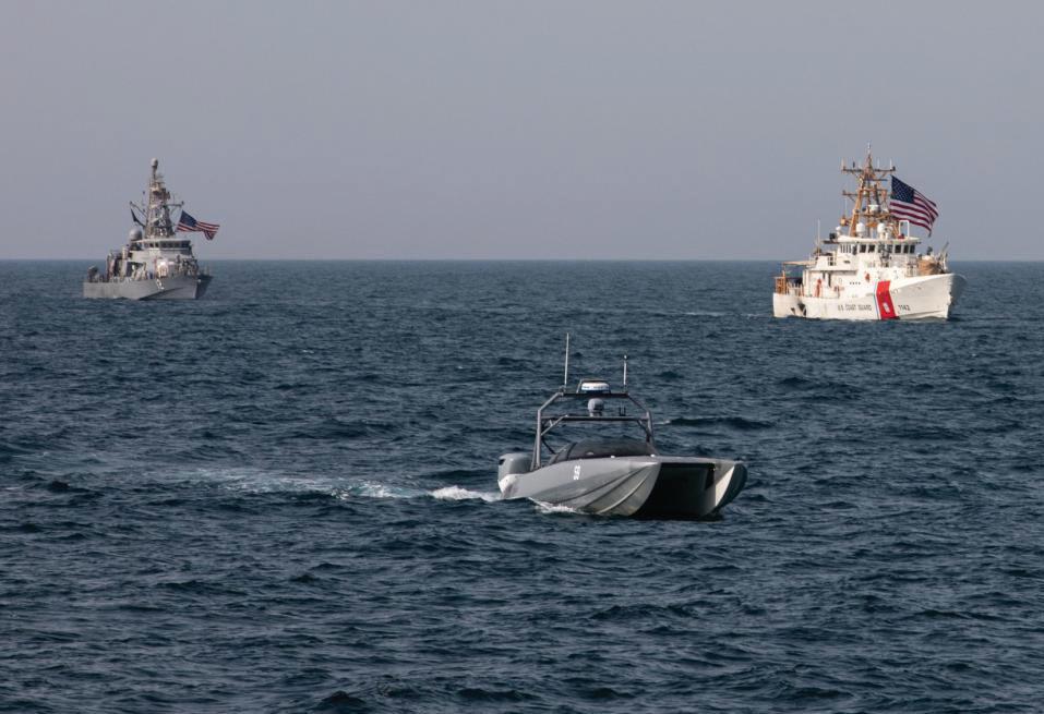
Juxtapose this dependence on legacy offshore energy protection systems with the rapid production and use unmanned surface vehicles (USVs) today. These USVs are being fielded in both the military and civilian world and as these assets are put into the hands of operators, new and innovative ways are being generated to perform missions heretofore done by manned systems. One of the most prominent is that of protecting offshore energy sources.
Much of the impetus to use unmanned surface vehicles for these kinds of civilian missions emerged from their use in military exercises, experiments, and demonstrations. Spurred by the need to have USVs perform some of the dull, dirty, and dangerous work previously performed by naval vessels, the U.S. Navy and Marine Corps have evaluated these platforms as candidates to perform a wide array of missions.
After observing these USVs capably perform these military missions
over many years, civilian users began to evaluate their use for non-military missions such as port and harbor security, environmental sampling and monitoring, navigation applications, hydrographic surveys, water quality monitoring, and mobile inspections of bridges, dams, oil platforms, and pipelines among others. While these missions are important, it is the last one that is most urgent.
While there are any number of capable and affordable unmanned surface vehicles either currently in the field or in various stages of design or production, I will focus on one platform that is a commercial-off-theshelf system that has been in use for almost a decade and that has been “wrung out” in a wide-variety of military and civilian events.
Maritime Tactical Systems, Inc. (MARTAC), a Florida-based manufacturer of unmanned surface vehicles, has fielded a family of low-cost, rugged and adaptable MANTAS T12 and Devil Ray T24 and T38 unmanned surface vehicles. Part of the attraction of using these USVs to inspect offshore oil and gas platforms, pipelines, and offshore wind farms is that these unmanned surface vehicles have seen extensive use in military exercises, experiments, and demonstrations, as well as hundreds of hours of use in a number of civilian missions ranging from commercial canal and dam hydrography, to commercial power plant inspections, to port and harbor security.
technology include:
• For surface investigation, the Devil Ray, which is already equipped with a Furuno DRS4D-NXT Doppler Radar and AIS, could also carry a SeaFLIR 280-HDEP Multi-Spectral Surveillance System.
• For underwater imaging, the Devil Ray can be equipped with Norbit iWBMS STX multi-beam sonar, a forward-looking or side-scan sonar, or any of many other commercial-off-the-shelf underwater sensors.
• Since one of the early indicators of material failure of oil rig components
above and below water.
If the USV discovers an anomaly and links the video back in real-time, the operator will be alerted and can command the Devil Ray to linger in a particular area for more granular analysis. If this investigation uncovers an area of concern, then a diver can be deployed to make a repair.
The same USV technology that is poised to assist the oil and gas and offshore wind farm industries is already being used to inspect critical infrastructure such as harbors, ports, inland waterways, dams, levees, canals, bridges, and other infrastructure that cannot be safely or effectively inspected by humans.

For example, a MANTAS T12 was used to conduct inspections of the Keokuk dam and energy center, the Bagnell energy center, the Elkhart hydro dam, the Central Arizona Project canal, and other infrastructure.
Off-the-shelf technology like this can be used to effect faster and more complete inspections of offshore oil and gas platforms, along with their surrounding bottom mounted pipelines, as well as offshore wind farms, while dramatically decreasing the need for human divers. Three primary missions where those responsible for oil rigs, pipelines, or offshore wind farms would utilize this USV
involves oil and other material from the rig seeping into the surrounding water, the Devil Ray can be equipped with water-monitoring sensors to include Acoustic Doppler Current Profilers (ADCP), Current-Temperature Depth (CTD) sensors, flourometers, and other systems to detect changes in the water quality.
In each of the above missions, a controller would have real-time camera, sonar and/or water quality visibility of the observations being made by the USV. While there are many ways to employ these USVs to protect offshore energy sources, one initial use would be for an operator to have a Devil Ray on patrol on a predictable pattern inspecting the asset
The enormous investment that energy companies have made—and will continue to make—in offshore oil and gas rigs and offshore wind farms is one that these businesses must protect against failure, sabotage, or other hazards. Current means of inspecting these rigs are slow, costly, and hazardous. Employing commercial-off-the-shelf USVs can enhance the ability to safely and effectively deliver energy to the world. ■
George Galdorisi is a retired U.S. Naval aviator and is now director of Strategic Assessments and Technical Futures for the Naval Information Warfare Center Pacific. His 30-year career culminated in 14 years as executive officer, commanding officer, commodore, and chief of staff. During his final tour of duty he led the U.S. delegation for military-to-military talks with the Chinese navy.

College of the Canyons
Land Surveying
26455 Rockwell Canyon Road
Santa Clarita, CA 91355 (661) 362-5096
Email: Regina.Blasberg@canyons.edu
Website: www.canyons.edu/SURV Associate of Science Degree Courses offered ONLINE (Video Conferencing)
New Mexico State University

Navigation Electronics, Inc.
124 Toledo Drive
Lafayette, LA 70506 (337) 237-1413
Website: www.neigps.com
Georgia Office: (770) 729-8005
Alabama Office: (256) 665-5589
Mississippi Office: (662) 347-1117
Arkansas Office: (870) 273-6333
Florida Office: (850) 228-2070
Seiler Instrument Geospatial
Offices in IL, IN, KS, KY, MI, MO, NE, WI 877-330-6303
Email: servicedept@seilerinst.com Website: www.seilergeo.com
Cypress Survey’s, Inc.
A well-established Land Survey Business in Central Florida with a solid reputation and loyal customer base. The Owner is looking to sell the business to someone to build on its success. In business since 1988, a profitable business with significant opportunities for growth. Current employees ready to continue with existing contracts which may run up to 2 years. Owner may provide owner financing. Please contact Steve at 863-299-8165 or email to cypressland@msn.com for more information.

Geomatics Department 1060 Frenger Mall – Room 130 Las Cruces, NM 88003
Phone: (575) 646-6748
Email: kwurm@nmsu.edu or elaksher@nmsu.edu
Website: https://et.nmsu.edu/geomaticssurveying//
Fully online program and +2 option. BS Degree
Troy University
Surveying and Geomatics Sciences Program
Geospatial Informatics Department 344 Wallace Hall Troy, AL 36082
Phone: (334) 808-6727
Fax: (334) 670-3796
Email: geospatial@troy.edu
Website: www.troy.edu/geospatial BS Degree, ABET-ASAC accredited www.instagram.com/troygeospatial www.tiktok.com/@troy_geospatial
University of Maine
Surveying Engineering Technology Program 5711 Broadman Hall, Room 119 Orono, ME 04469-5711
(207) 581-2340
Email: um.set@maine.edu
Website: http://www.umaine.edu/set/svt/ Bachelor Degree. abet-taac
Writers like Gavin Schrock, Marc Delgado, Linda Duffy, and Juan Plaza make up the best team of geospatial writers in the business and their articles fuel xyHt’s editorial product. But we always want to make sure we are on top of the advances in technology that drive the geospatial world, so our editorial board meets every few months to help keep xyHt on track.
The editorial advisory board consists of representatives of different companies who provide our content team with input and ideas
to make sure that we’re writing about the unique, the challenging, and the collaborative projects that make this business so interesting.
Over the last few years, topics including the need for a youth movement, the blue economy, digital twins, and more have come from our board. This year’s board reflects another effective mix of professionals who will continue to provide input about the relevant content that showcases activities and challenges that many of our readers encounter throughout the year.
Here is a quick introduction to this year’s board.

Tim Burch
Executive Director, NSPS (3rd year)

Karen Schuckman
Executive Director, ASPRS (3rd year)

Tripp Corbin

Jeff Fagerman CEO, LiDAR USA (3rd year)
GIS Business Development Mgr., SAM (3rd year)

Kim Hansen

Geospatial Marketing Director, Woolpert (2nd year)
Malek Singer
Product Manager, Airborne, Teledyne Geospatial (2nd year)

Ron Oberlander

VP, Global Professional Services, Topcon (1st year)
Linda Foster Global Manager, Land Records/Cadastre, ESRI (1st year)

Jesse Huff

General Manager, Tersus GNSS (1st year)
Matt Bethel Director of Operations and Technology, Merrick (1st year)


