3 minute read
CUF Is...


Population: Who and Where?
Where?
Advertisement
While the population is spread out relatively even among the six census tracts, the densest tract by far is Tract 30, which is where the University of Cincinnati is located, and where all the dormitories are. While CUF has a ton of housing units, there aren’t many residents per unit. Excluding Tract 30, the average person per unit in CUF is 2.3 This because the inundation of UC students means that there are barely any families; what replaces them are pairs of roomates.
Defined by statistics that illustrate the residents and their lives, supporting the presence of original infrastructure and the increasing strength of the university
Population: Who and Where?
Who?
Where?
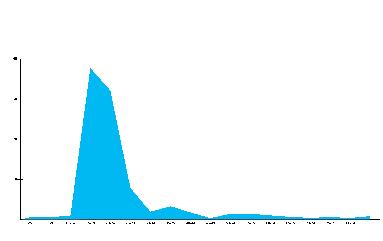
CUF’s population is overwhelmingly young, with a little over falling between the ages of 15 to 29
Population: Who and Where?
While the population is spread out relatively even among the six census tracts, the densest tract by far is Tract 30, which is where the University of Cincinnati is located, and where all the dormitories are. While CUF has a ton of housing units, there aren’t many residents per unit. Excluding Tract 30, the average person per unit in CUF is 2.3. This because the inundation of UC students means that there are barely any families; what replaces them are pairs of roomates.
Where?
While the population is spread out relatively even among the six census tracts, the densest tract by far is Tract 30, which is where the University of Cincinnati is located, and where all the dormitories are. While CUF has a ton of housing units, there aren’t many residents per unit. Excluding Tract 30, the average person per unit in CUF is 2.3 This because the inundation of UC students means that there are barely any families; what replaces them are pairs of roomates.
Who?
The map and chart to the right show a stark contrast between density where the campus is and where the homes are, illustrating a neighborhood that has a sizable shift in feel where the campus is.
Who?
CUF’s population is overwhelmingly young, with a little over 77% of all residents falling between the ages of 15 to 29
CUF’s population is overwhelmingly young, with a little over 77% of all residents falling between the ages of 15 to 29
To the left, the graph shows the age distribution of CUF, where the curve skyrockets once it gets to the 15-29 years old range, showing that the majority of the neighborhoods makeup is students living where families use to live.
Percentage of housing that is occupied by renters, in green, totals 82.2% and owners, in orange, totals 17.3%. Given renters dominate the housing supply residents in CUF are constantly in-flux.
Dense housing supply was built at the time of CUF first being settled and that has lended itself to flexibility needed by UC students who are constantly leaving for co-ops and gradution.
33.45% College Town
ESRI Tapestry is an index defining the characteristic feel of places by zip code. As seen in blue, CUF has a strong presence influencing both zip codes to have a predominate College Town feel.
The extent of UC’s influence is codified. Shifting demographics are defined by number of residents enrolled in college who are becoming used to new responsibilities and seek variety and adventure.
Only 7.6% of CUF residents are employed within
Many residents work in neighborhoods adjacent to CUF
The map to the left gives data for code enforcement cases (trash, abandoned car, grass unkempt, etc.) for the last year for CUF. CUF has the 5th highest complaint rate in the city.
Of the 264 complaints, 170 of them were for Trash/Litter/Tall Grass. This percentage is the highest in the city.
The majority of the complaints are compiled in the residential dense areas of the neighborhood, revealing that the damage is being done closest to where people call home.
In this building footprints map, the duality of the building typologies can truly be appreciated. Large university, hospitals, and apartment complexes can be seen in stark contrast to the tightly packed row home streets and businesses. These sudden changes in morphology can cause barriers in the neighborhood fabric.

This map also illustrates the many parks of CUF, scattered throughout the residential cores, proving that one is never too far from a green space.
CUF’s land is dedicated to the campus, surrounding housing, and parks. This space provides an area for students and families to live comfortably. These areas are the foundations for a model neighborhood.
CUF is a highly connected neighborhood that accommodates for a variety of transportation modes. Major characteristics are the vehicle major roads that border the neighborhood that carry heavy traffic while being pedestrian borders and historic street grids that have smaller blocks and heavy pedestrian traffic.
Influence of new dynamics created by university students’ needs have increased activity at the border of the more historic area that has been lined with new business developments.
Legend
Intersection Density
High Density
Busy Density
Average Density
Low Density Local Connector
Road Types Walk Shed
Vehicle Major Road
Mixed Major Road Highway
221 Atkinson St, 15 mins
437 Ada St, 15 mins
606 Riddle Rd, 15 mins
CUF Is...
Composed of various pockets formed from the competing dynamics of the neighborhood and university cores.