^ AI TR
HIA N
R
1.9
40.2526, -76.9912
B7
Good Hope Access
3.7
40.2588, -76.9758
B8
Conodoguinet Youth Park
4.1
40.2523, -76.9577
0.8
40.2766, -76.9427
B12
Siebert Park
1.4
40.2544, -76.9269
B13
Pine Hill Arboretum
1.0
40.2703, -76.9323
B14
Ridley Park
0.3
40.2706, -76.9213
B15
Rupley Park
0.1
40.2689, -76.9151
B16
West Fairview Park
0.1
40.2720, -76.9172
B17
West Fairview Point
Take-Out Only
40.2732, -76.9140
Mechanicsburg A WM
IN
ST
^
§ ¦ ¨
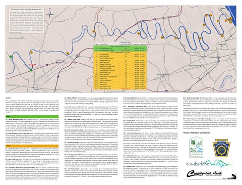
B10 - oyster mill Park: Oyster Mill Park is a 1-acre park owned by East Pennsboro Township at 1150 Oyster Mill Road, Camp Hill. The park provides convenient creek access, picnicking and fishing. Limited parking is available. For more information, contact East Pennsboro Township at (717) 732-0711, or visit the township online at www.eastpennsboro.net.
Huston Mill, located in Willow Mill Park, has been a local landmark since the late 1790s. The mill structure is named for James S. Huston, who owned and operated the gristmill from the 1880s through the early 20th century. Today, evidence of the mill race and interior machinery is gone, but the mill building survives as a reminder of past times. For more information, contact Silver Spring Township at (717) 766-1657 or visit the township online at www.silverspringtwp-pa.gov.
B11 - adams-ricci Community Park: This 130-acre municipal park is owned by East Pennsboro Township and located at 100 East Penn Drive, Enola. Adams-Ricci offers a variety of amenities including baseball, softball, basketball, tennis, playground equipment, volleyball, hiking, biking, fishing, picnicking and pavilion rentals. Recommended parking for creek access is near the West Enola Pavilion or the Keystone Pavilion. Walk-in access to the creek is provided via a steep nature trail. For more information, contact East Pennsboro Township at (717) 7320711, or visit the township online at www.eastpennsboro.net.
B6 - Westover Commons area: Westover Commons is a 10-acre passive park located in the Westover subdivision of Hampden Township. This natural area is completely undeveloped and is accessible for walking, bird watching, bank fishing and other passive leisure uses. Access to the creek is from the 6200 block of Stevens Crossing, Mechanicsburg. Only limited on-street parking is available. For more information, contact Hampden Township at (717) 761-4951, or visit the township online at www.hampdentownship.us. B7 - good Hope access: Good Hope is owned and maintained by the Pennsylvania Fish & Boat Commission (PFBC). This 1-acre site is located in Hampden Township at 915 Good Hope Road, Mechanicsburg. The facility provides convenient creek access for boaters (unpowered boats only) and shore fishing is also permitted. A PFBC launch permit is required. Limited parking is available at the site. For information on other Pennsylvania Fish & Boat Commission facilities, visit www.fishandboat.com. B8 - Conodoguinet youth Park: The Conodoguinet Youth Park is an 8-acre park located at 515 Orr’s Bridge Road, Camp Hill. Hampden Township and the Mechanicsburg North Rotary Club have worked cooperatively to plan, develop and construct the improvements at this creekside park. The park offers ample parking, restrooms, a picnic pavilion, picnic tables, fire rings and a fishing dock. Overnight camping is permitted by certain organized groups by reservation only. For more information, contact Hampden Township at (717) 761-4951, or visit the township online at www.hampdentownship.us. B9 - acri meadow Park: This site is a 4-acre municipal park owned by East Pennsboro Township. The park is located at 55 Acri Meadow Drive, Enola. The park offers a launch ramp for unpowered boats, fishing, picnicking and a pavilion. Other available activities include baseball, basketball, volleyball and a playground. For more information, contact East Pennsboro Township at (717) 732-0711, or visit online at www.eastpennsboro.net.
E MA
G
TY ET
1 RT 1 RT
5
5
U SB
RG
RD
S
N SL AT
S CREE HE C
EH
ILL
RD
76
B4 - Willow mill Park: Willow Mill Park is an 18-acre municipal park owned by Silver Spring Township. The park is located off PA Route 114 at 80 Willow Mill Park Road, Mechanicsburg. Park amenities include: canoe launch, boat launch, hiking, fishing, disc golf, picnic pavilions and grills, portable restrooms and ample parking.
B5 - Hidden Creek Park: Hidden Creek Park is a 14-acre park owned by Silver Spring Township and located at 50 Millfording Road, Mechanicsburg. The park offers convenient creek access, fishing, soccer fields, portable restrooms and ample parking. The park also offers a scenic walking path along the creek. For more information, contact Silver Spring Township at (717) 766-1657 or visit the township online at www.silverspringtwp-pa.gov.
Y RD
^
K
1.8
FERR
R
Adams-Ricci Community Park
W TRINDLE RD
40.2665, -76.9518 40.2763, -76.9489
SO N SIMP
D
B11
O RD TEXAC 0.3
Shiremanstown
Y
Oyster Mill Park
E
RD LE ND I R T
LE
Acri Meadow Park
RD
ES W
B9 B10
N
REE
Westover Commons Area
Y RD FERR
WB
B6
W
SO N SIMP IN ST
O
40.2533, -77.0099
ST O
RD
1.2
GE
YE LL
Hidden Creek Park
HO
UR N
SILVER SPRING RD
B5
ST ST
40.2578, -77.0426
D ST
6.5
S 32N
Willow Mill Park
N 21
D PE R
B4
LIS B
APPALAC
N ET UI G
ST
D HO
CARLISLE SPRINGS RD
R TE
GO O
40.2604, -77.1045
RT 581 E
T
B3 - scott farm Work Center/appalachian trail: The Scott Farm is a trailhead and work center for the Appalachian National Scenic Trail. This site is located at 301 Bernheisel Bridge Road, Carlisle, and owned by the National Park Service. Creek access is permitted on the south side of the bridge. Parking is limited; users must contact the Appalachian Trail Conservancy to determine parking availability. Driving and parking on the grass are strictly prohibited. There are no sanitary facilities and users must pack out all trash. For more information, contact the Appalachian Trail Conservancy at (717) 258-5771, 9 a.m. to 5 p.m. Monday through Friday.
5.5
D
TS
B2 - letort falls Park: Letort Falls Park is a 2-acre park located in Middlesex Township in the 100 block of North Middlesex Road, Carlisle. Amenities at the site include a boat launch, parking and creek access for fishing. For more information, contact Middlesex Township at (717) 249-4409 or visit the township online at www.middlesextwp.com.
Appalachian Trail
RT 581 W
KE AR
B1 - Creekview Park: Creekview Park is a neighborhood park located in North Middleton Township at 2309 Douglas Drive, Carlisle. This 10-acre park offers walk-in creek access, fishing, a multipurpose field, playground equipment and a picnic pavilion. No off-street parking is available. For more information, contact North Middleton Township at (717) 2438550, or visit the township online at www.nmiddleton.com.
TRINDLE RD
B3
R LE ND TRI
SM
triP B
40.2375, -77.1409
T
a2 - Cave Hill nature Center (take-out only): Cave Hill is a 20-acre nature area owned by Carlisle Borough. The park is located off K Street at 6 Cave Hill Drive, Carlisle. It offers walk-in creek access, hiking and fishing. All boaters must take-out at this site. Cave Hill is not a put-in point because it is just upstream from the Carlisle Raw Water Intake Dam. Do not attempt to navigate over the dam! For more information, contact Carlisle Borough at (717) 249-4422, or visit the borough online at www.carlislepa.org.
4.6
T
a1 - north middleton Park: North Middleton Park is a 15-acre facility owned by North Middleton Township. The park is located off PA Route 74, 1700 Waggoner’s Gap Road, Carlisle, approximately 3 miles north of Carlisle. This park provides opportunities for boating, fishing and picnicking, as well as baseball, basketball and volleyball. A playground and pavilions are also available. Ample parking and a paved launch ramp allow for easy access to the creek. For more information, contact North Middleton Township at (717) 243-8550, or visit the township online at www.nmiddleton.com.
Letort Falls Park
KS OR
triP a
B2
SY
The Conodoguinet Creek Water Trail Map and Guide provides park and recreation information for approximately 40 miles of the Conodoguinet Creek. The trail begins near Carlisle at North Middleton Park and ends at “The Point” in West Fairview, where the creek flows into the Susquehanna River. This guide outlines two float trips: One short route, Trip A, west of the Carlisle Dam, and a second extended route, Trip B, east of the Carlisle Dam. There is no public portage at the Carlisle Dam. Do not attempt to navigate over the dam!
40.2386, -77.1913
RD INT
aCCess
3.2
TS NU
81
KR D
CARLISLE PIKE
N YORK ST
§ ¦ ¨
E HIGH ST
YO R
Camp Hill
^
RD
RD
Creekview Park
T PO
^Carlisle
NT
B8
40.2199, -77.1921
B1
C US
E NORTH ST
R LA C
O EM
! (
MARKET ST
TE
HA
Take-Out Only
C
RD
B12
40.2344, -77.2198
STA
N
NO
R VE
ST
Cave Hill Nature Center
N LO
W HIGH ST
H
G
E P IK
D YR
B ST
ALR
A2
UR
A2
2.3
AL NW
V CA
! (
B RIS AR
North Middleton Park
PO
AR PL
H RC HU
! (
Latitude & Longitude
Scott Farm Work Center/
I 76 ONRAMP
W X
A1
RD
! ( A1
§ ¦ ¨
RD
Y W
Access Point (Miles)
Access Point
Y LLE
B2
W I 76 76
B6
TRIP B - Approximately 36.5 miles
! (
DANGER
! (
Distance to Next Label
N CE
PK
! ( VA
! ( B1
B7
AP
ET
C RE EK
ND
N UI
N
! (
B5
O OD
B15
EN TP
G
! (
W DR
S EA
BS G LAM
DO
VALLEY VIE
TRIP A - Approximately 2.3 miles
R NE RIT
B9
B4
H RIC
CO
Y HW
! ( NO
Miles
NEWVILLE RD
! (
O C
! (
! ( ! ( ! ( ! ( B14
B13
B17 B16
R
81
B3
RD
E RIV
§ ¦ ¨ 1S
E
NA AN
( ! ( ! B11
B10
I8
1
ST AT
H UE
NG
RD
SQ SU
RI SP
^
Y RD
Although each of the access points highlighted in this guide are located on public property, most of the shoreline along the water trail is in private ownership. Respect the privacy and rights of landowners by obtaining permission before entering any privately owned land. Avoid making noise and boisterous behavior. Remember that sound carries across water much louder than RD OLA Many of the landown ers enjoy the peace EN land. and solitude of the creek from their decks and living rooms. Share the same courtesy that you would want. A friendly wave or quiet greeting is always welcome!
Enola
L
LLE RICH VA
Ü
Respect the Privacy and Rights of Landowners
LE RD WERTZVIL
B12 - siebert Park: Siebert Park is a 60-acre municipal park owned by Camp Hill Borough. The park features an arboretum, pavilions, hiking and biking. It also offers a playground, basketball, tennis, an athletic field, running track, swimming pool and volleyball. Access to the creek and parking for boaters is provided along Creek Road at the lower end of the park. For more information, contact Camp Hill Borough at (717) 737-3456, or visit the borough online at www.camphillborough.com. B13 - Pine Hill arboretum: Pine Hill is a 15-acre arboretum owned by East Pennsboro Township. The arboretum extends from the bank of the Conodoguinet Creek across Creekside Drive and up the hill to Humer Street. This unique site provides opportunities for nature exploration, hiking, boating and fishing. Access to the creek is by walk-in only. Parking is limited to a small unpaved area along Creekside Drive, Enola. Pine Hill was originally the summer home of local medical doctor Harvey B. Bashore. Dr. Bashore was a noted naturalist and wrote a number of books and articles on health, sanitation and local history. Many species of wild flowers, trees and ferns as well as birds and mammals have been identified and documented at the arboretum. For more information, contact East Pennsboro Township at (717) 732-0711, or visit the township online at www. eastpennsboro.net. B14 - ridley Park: This site is a 16-acre park owned by East Pennsboro Township. The facility is located at 1625 Matthew Road, Camp Hill. Ridley Park provides creek access, hiking, fishing and a pavilion. Other available activities include baseball, basketball, volleyball and playground equipment. For more information, contact East Pennsboro Township at (717) 732-0711, or visit the township online at www.eastpennsboro.net. B15 - rupley Park: Rupley Park is an 11-acre neighborhood park owned and maintained by Wormleysburg Borough. The entrance to the park is located at 401 West Crestwood Drive, Camp Hill. Facilities in Upper Rupley Park include playground equipment, picnic tables and a small pavilion. Lower Rupley Park is more primitive and provides opportunities for hiking, fishing and boating. Access to the creek is by walk-in only. No off-street parking is available. For more information, contact Wormleysburg Borough at (717) 763-4483, or visit the borough online at www.wormleysburgpa.org.
B16 - West fairview Park: West Fairview Park is a 24-acre municipal park owned by East Pennsboro Township. The entrance to the park is located at Fourth and McCormick Streets in Enola. Park amenities include a baseball field, basketball courts, playground equipment, picnic tables and opportunities for fishing, hiking and boating. Access to the creek is by walk-in only. The remains of an old mill can be found at West Fairview Park. The Harrisburg Nail Works was erected on this site in 1810. At its height, the company produced 6,300 tons of nails annually. West Fairview Park still includes some of the arches and foundation of the old mill, which was dismantled in the early 1900s. For more information, contact East Pennsboro Township at (717) 732-0711, or visit the township online at www.eastpennsboro.net. B17 - West fairview Point (take-out only): Known by the locals as “The Point,” this site provides a paved boat launch at the confluence of the Conodoguinet Creek and the Susquehanna River. The area is located at 50 Front Street, Enola, and is maintained by East Pennsboro Township. Portable toilets and picnic tables are provided, but parking is limited. For more information, contact East Pennsboro Township at (717) 732-0711, or visit the township online at www.eastpennsboro.net.
PROJECT PARTNERS & SPONSORS
^