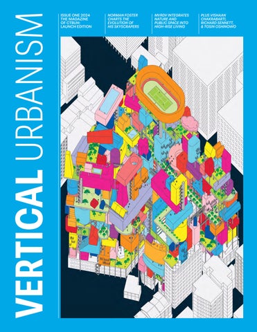
ISSUE ONE 2024 THE MAGAZINE OF CTBUH: LAUNCH EDITION
NORMAN FOSTER CHARTS THE EVOLUTION OF HIS SKYSCRAPERS
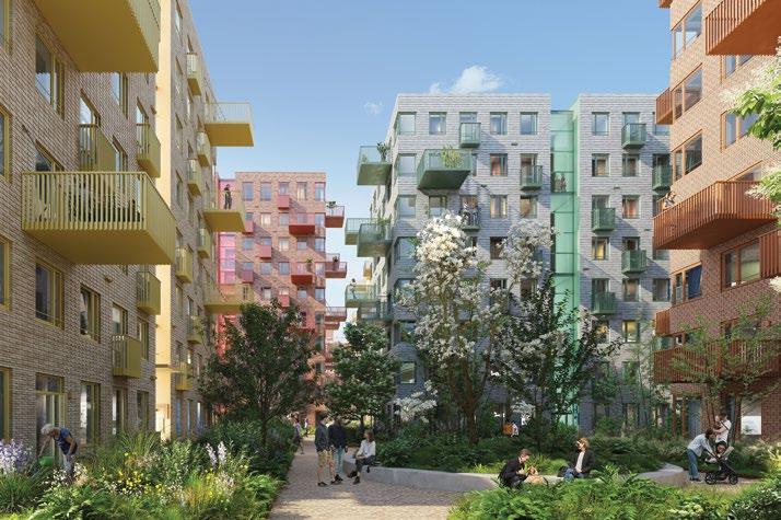
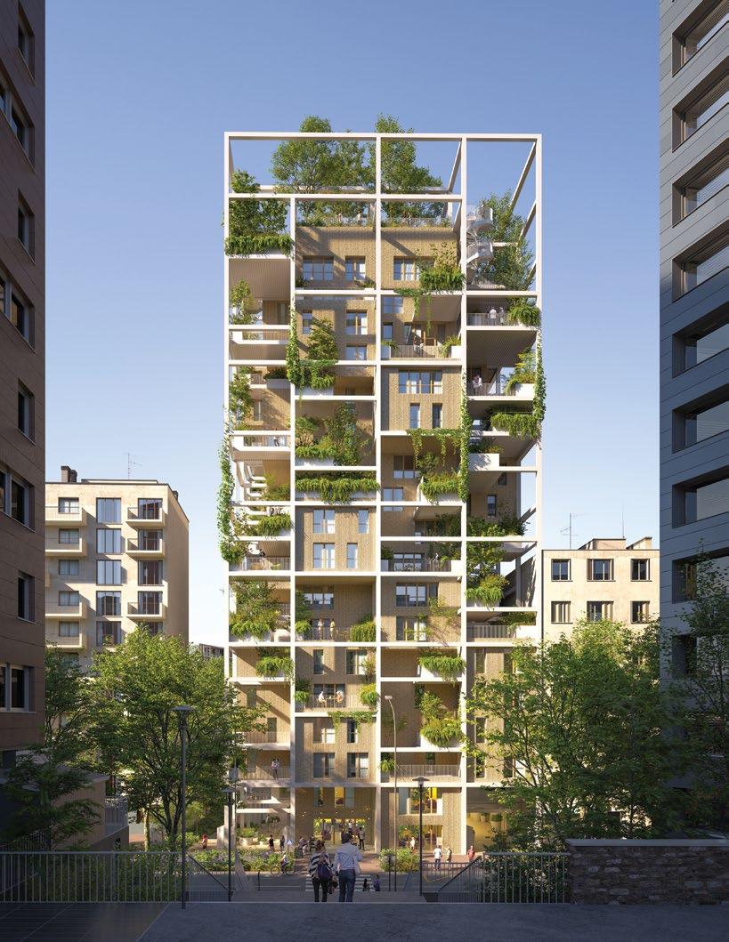
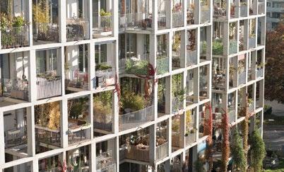
MVRDV INTEGRATES NATURE AND PUBLIC SPACE INTO HIGH-RISE LIVING
PLUS VISHAAN CHAKRABARTI, RICHARD SENNETT, & TOSIN OSHINOWO
Vertical Urbanism launches at CTBUH’s 2024 International Conference, “New or Renew?” This symbol is used throughout the issue to indicate content related to the conference. Visit ctbuhconference.com
WELCOME TO ISSUE ONE OF CTBUH’S new flagship magazine. The concept “vertical urbanism” has been gestating at CTBUH for some time. It describes a holistic approach to understanding and improving the cities in which we live, exploring how increased density and vertical growth can support more sustainable and healthy cities. “Tall” is still our center of gravity, but with greater height comes greater horizons. Rather than ask, “How can we build taller?” we’re asking, “How can verticality improve our cities?”
On a planet that is becoming increasingly urbanized, we advocate for efficient and humane high-density environments that will cater to future generations. Vertical urbanism is a kit of parts where tall buildings are critical, but so are the concepts, policies and technologies that allow them to integrate with the bigger picture, including the social component. We’re building for better lives, together. We’re shaping the future through engagement, innovation, and transformation to create cities that rise to meet the challenges of tomorrow.
There are four distinct magazine sections, each of which explores vertical urbanism through a different lens. “Agenda” provides sharp, analytical briefings on recent news, wellconsidered opinions, and longer-form essays.
This issue places Norman Foster alongside Richard Sennett. “Focus” features detailed examinations of buildings, designs, technology, practices and people. This includes the inaugural City Advocacy Forum, which took place in Miami earlier this year, met again in Istanbul and London. It is the Council’s initiative to bring together city planners from around the world for intimate, in-depth conversations about best practices in managing density and fostering sustainability.
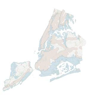
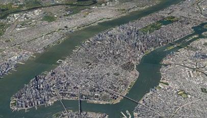
“Research” covers both independent and CTBUH research and commissions. In this edition, leaders from PAU expound on the potential for their home city New York to accommodate some one million new residents. “Insight” brings us inspiration: in this issue, John Zils, the 2024 Fazlur Khan Lifetime Achievement Award Winner, relays lessons learned from the man himself.
This is a special (double) issue for another reason. It coincides with the 2024 International Conference, “New or Renew?” held in London and Paris. Wherever you see the symbol (shown to the left), it denotes an article related to a building or person featured in the conference.
To deliver this relaunch, we’ve collaborated with Will Hunter, who joins as executive editor. For more on our new publication, see “Bulletin” (p. 9). I extend a warm welcome to all readers, old friends and new acquaintances alike.
Daniel Safarik, Editor-in-Chief
Publisher Vertical Urbanism is published by the Council on Tall Buildings and Urban Habitat (CTBUH).
ISSN: 2997-9463 (Printed)
ISSN: 2997-9471 (Digital)
Editorial
Editor-in-Chief: Daniel Safarik dsafarik@ctbuh.org
Executive Editor: Will Hunter will@will-hunter.com
Managing Editor: Martina Dolejsova
Associate Editor: Javier Quintana de Uña
Advertising: Jen Hall
jhall@ctbuh.org
Production: Tansri Muliani
Editorial
Advisory Board
Isabel Allen Reed Kroloff
Editorial policy
As a platform for interdisciplinary discourse on the sustainable densification of cities, Vertical Urbanism solicits articles from diverse fields of expertise. Contributors are independent from CTBUH, unless explicitly stated otherwise. The opinions expressed by contributors are their own and do not represent CTBUH’s official stance nor carry its endorsement.
Submissions
We welcome content ideas from our readers. Please email submissions to the Editor.
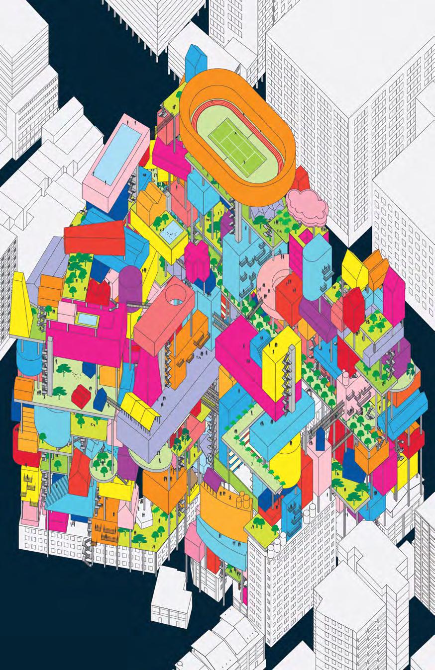
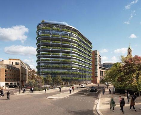
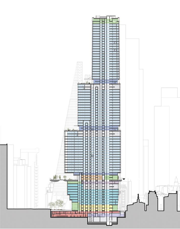
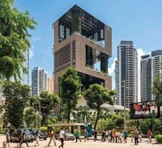
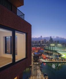
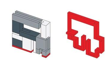
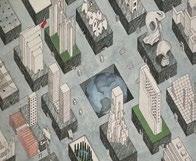
Cover
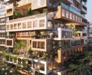
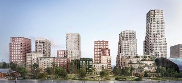
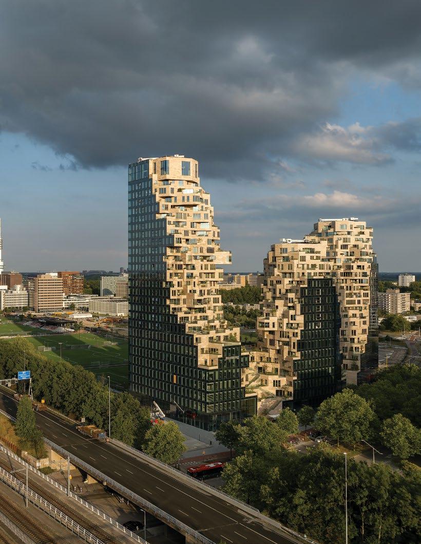
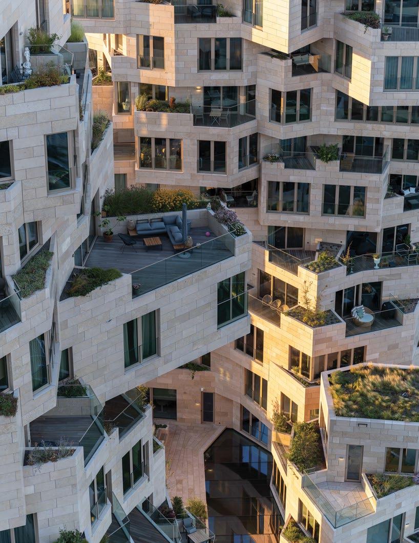
The Vertical Village, by MVRDV, 2013 (see page 82).
CONTENTS
Insight Research Focus Agenda
6 BULLETIN
Commentary on the future of American downtowns, a high-rise planning dispute in the UK, and the real reason TAIPEI 101 withstood the recent earthquake.
13 OPINION
Marc Norman on why Hollywood films don’t capture the resilience of cities.
14 ANALYSIS
Austin Williams explores what the future holds for Chinese cities.
20 REPORT
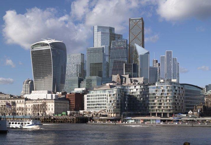
Arup weighs up whether building tall is a good use of society’s carbon, explored through London case studies (below).
26 REFLECTION
Norman Foster looks back on his incredible career through the design of skyscrapers.
30 ESSAY
Richard Sennett argues for cities to have openness in their planning to enable urban life to thrive.
38 DESIGN
Exemplar adaptive reuse projects that will transform London’s obsolete offices.
48 CITIES
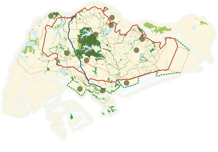
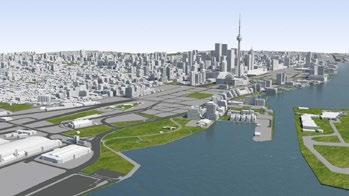
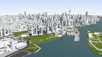
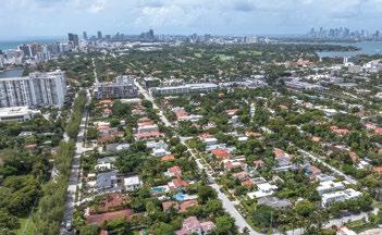
The inaugural City Advocacy Forum, a new initiative by CTBUH, discusses planning approaches in London, Miami, Toronto and Singapore.
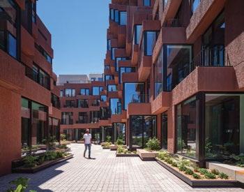
64 DESIGN
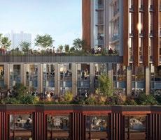
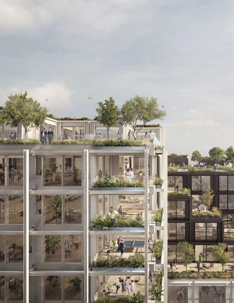
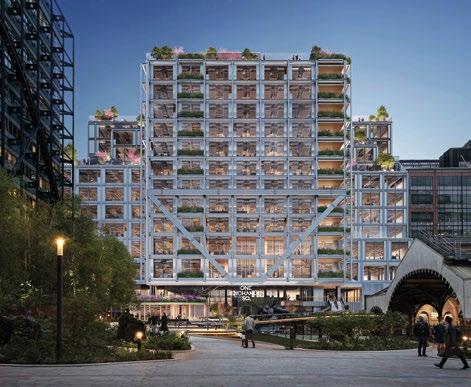
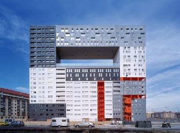
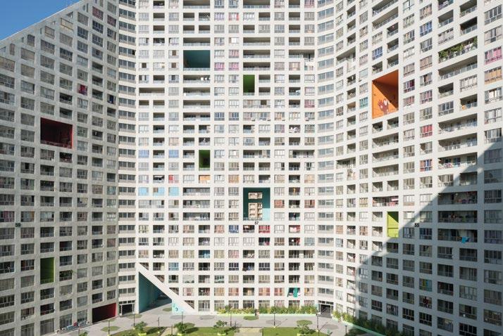
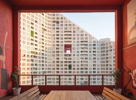
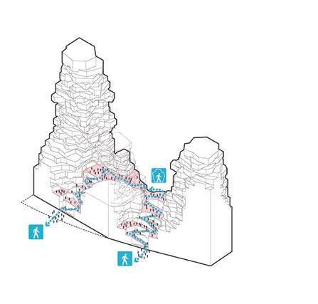
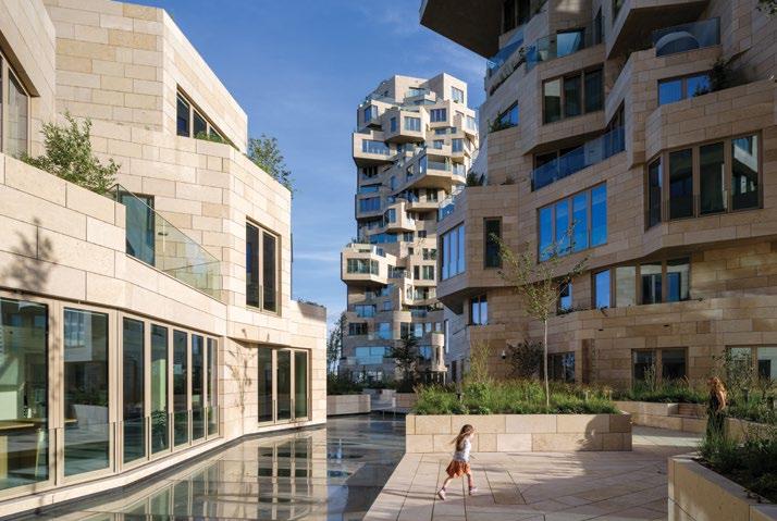
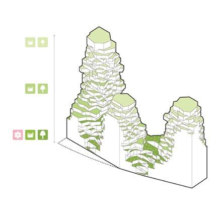
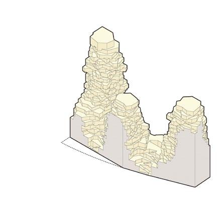
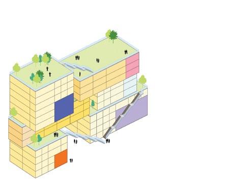
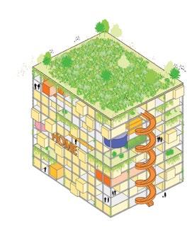
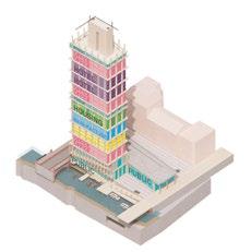
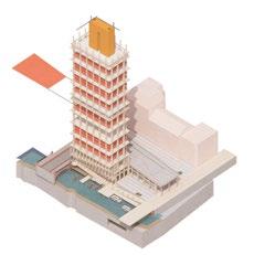
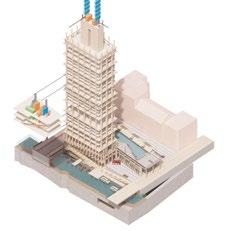
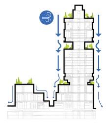
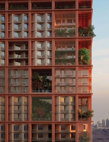
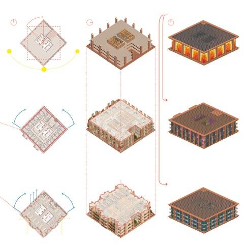
A discussion with the three founding partners of Dutch practice MVRDV about their pioneering approach to designing tall buildings (below)
90 TECH
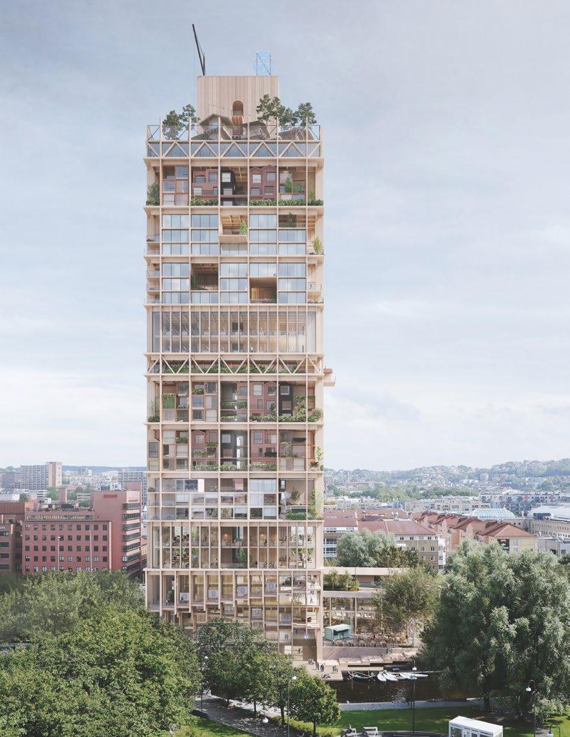
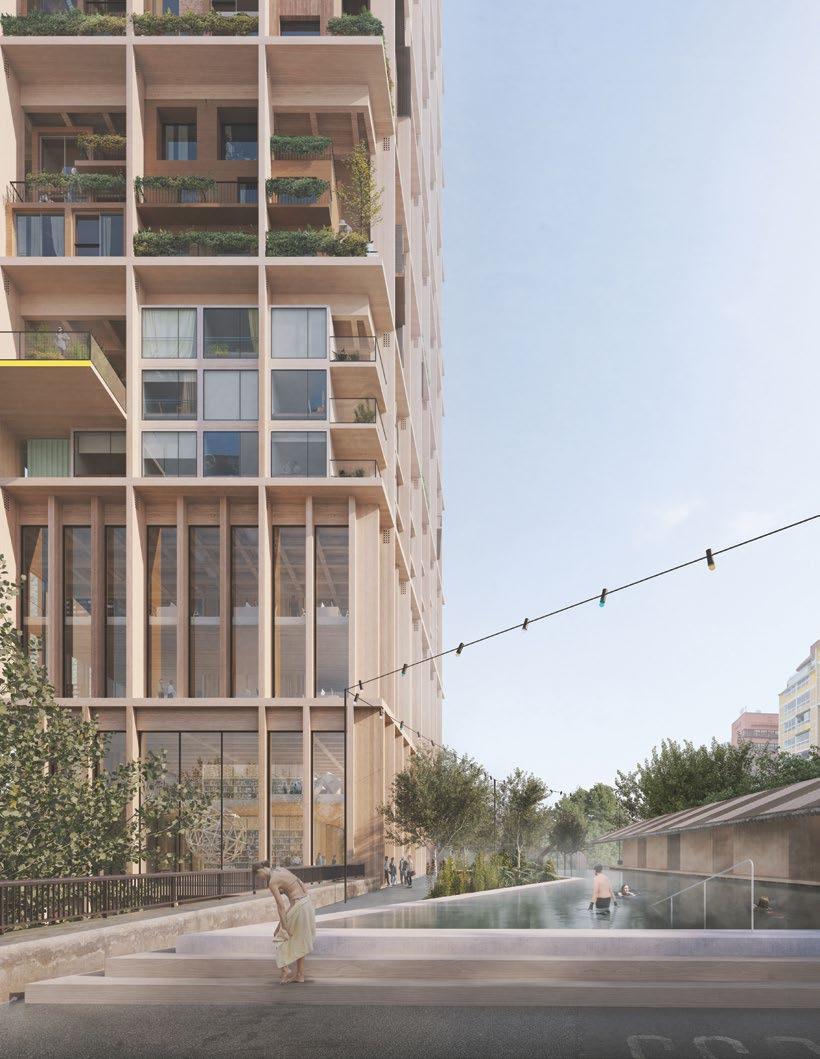
Haptic and Ramboll have pioneered a regenerative timber tower that can be adapted to different climates.
100 DESIGN
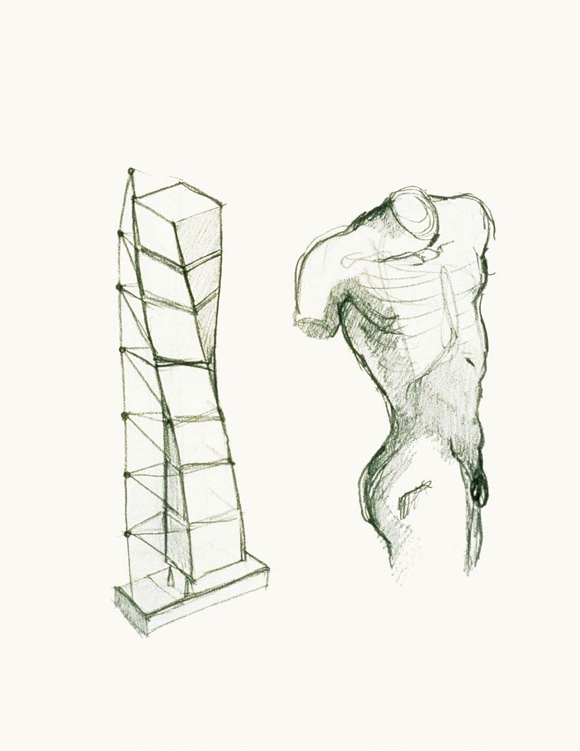
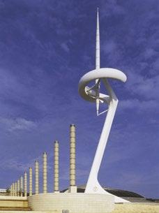
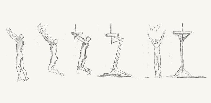
Santiago Calatrava explains how his art practice has informed the corpus of his architecture.
106 TECH
A proposed tower in Perth is an exemplar of hybrid timber construction.
110 PAPER
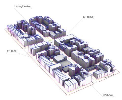
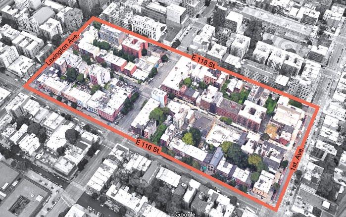
Vishaan Chakrabarti and Skylar BisomRapp discuss “How to Make Room for One Million New Yorkers.”
118 PAPER
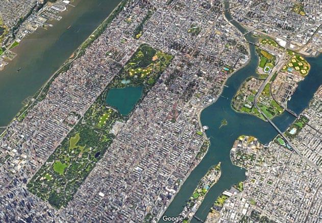
Tess McCann compares privately owned public spaces in London and New York.
126 PAPER
How Dutch architect
John Habraken influenced notions of artificial land and support/infill housing in Japan, by Casey Mack.
134 PAPER
Rahman Azari and Arjun Janardhanan on how to model urban carbon emissions.
142 DATA
CTBUH’s data team reports on trends from Europe related to the conference “New or Renew?”
144 DIGEST
A summary of the most germane findings from recent peer-reviewed urban research papers (below).
146 INSPIRATION
John Zils, the 2024 Fazlur Khan Lifetime Achievement Award Winner, relays lessons from his mentor Khan.
148 ARCHIVE
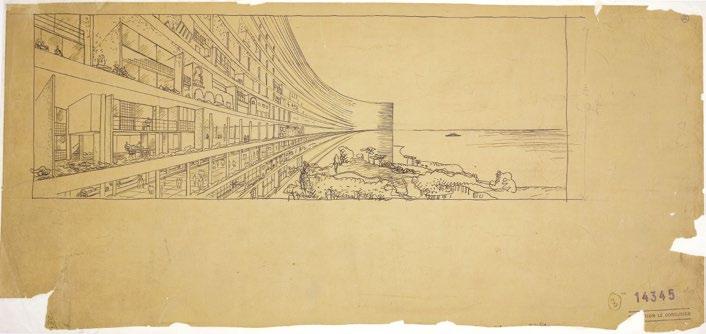
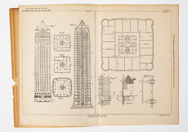
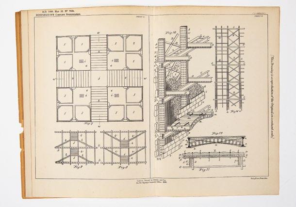
Niall Hobhouse curates a history of the skyscraper through drawings.
154 REVIEWS
Book reviews covering how to build a sustainable planet, post-fossil building construction, cities of tomorrow and feminist urbanism. Plus write-ups of the World Around’s research forum in London and Madelon Vriesendorp’s recent talk in New York City (below).
160 LETTER FROM Tosin Oshinowo reports on the changing urban dynamics of Lagos, Nigeria.
MASTER OF TALL BUILDINGS AND VERTICAL URBANISM
Apply now to an exciting new degree program–the only one of its kind–developed by the IIT College of Architecture and the Council on Tall Buildings and Urban Habitat.
Work with the world’s leading designers to shape a sustainable, equitable future.
Study in Chicago–the city that invented the skyscraper.
Applications Now being accepted. Scan the QR code to learn more.
CONTRIBUTORS
Focus Agenda
PAUL FINCH, who writes on a tower controversy (p. 7), is program director of World Architecture Festival, and a former editor of Building Design, The Architects’ Journal and The Architectural Review
CHRIS EDGINGTON, who evaluates the sustainability of building tall (p. 20), is associate director at Arup. He led the multi-disciplinary design team for 8 Bishopsgate.
NORMAN FOSTER, who reflects on his tall buildings (p. 26), is the founder and executive chairman of Foster + Partners and president of the Norman Foster Foundation. He is a winner of the Pritzker Prize and the Royal Gold Medal, and leads the Forum of Mayors for the United Nations.
MARK MATTHEWS, who contributes a piece on TAIPEI 101 (p. 9), is marketing and business development lead at Motioneering.
DENNIS POON, who co-authors the TAIPEI 101 piece (p. 9), is vice chairman and managing principal at Thornton Tomasetti.
RICHARD SENNETT, who pens an essay on open cities (p. 30), is a senior advisor to the United Nations on its Program on Climate Change and Cities. He is the author of many books, most recently The Performer: Art, Life, Politics (2024).
MARC NORMAN, who contributes an opinion piece (p. 13), is associate dean of the Schack Institute of Real Estate at New York University.
AUSTIN WILLIAMS, who analyzes China (p. 14), is a senior lecturer at Kingston School of Art, London, the director of the Future Cities Project and author of China’s Urban Revolution: Understanding Chinese Eco-Cities (2017).
SHAWN URSINI, who reports on the high-rise market (p. 6), is editor of CTBUH’s tall building database.
DIMITRIS ARGYROS, who writes in our Tech section (p. 90), is associate director of London-based Haptic Architects, where he leads its research and development arm.
JOHN BUSHELL, who writes about the 99 City Road development (p. 38), is planning principal at Kohn Pedersen Fox.
SANTIAGO CALATRAVA, who discusses his approach to tall buildings across his career (p. 100), is the winner of the 2024 CTBUH Lynn S. Beedle Lifetime Achievement Award. He is the founder of Santiago Calatrava Architects & Engineers.
ELIE GAMBURG, who writes about the 99 City Road development (p. 38), is design principal at Kohn Pedersen Fox.
FRANCISCO GARCIA, who is featured in the City Advocacy Forum section (p. 48), is a principal at The Euclid Group, and was director of planning and zoning for the City of Miami from 2010–20.
WILL HUNTER, who interviews MVRDV (p. 64) and chairs the City Advocacy Forum (p. 48), is the founder of the London School of Architecture.
MAREIKE LANGKITSCH, who writes on One Exchange Square (p. 38), is senior associate at Fletcher Priest.
WINY MAAS, who is interviewed in the Focus section (p. 64), is co-founder of Dutch practice MVRDV.
PETER MURRAY, who takes part in the City Advocacy Forum (p. 48), is the co-founder at New London Architecture and Mayor of London’s Design Advisor for Boris Johnson and Sadiq Khan.
JAMES PARAKH, who takes part in the City Advocacy Forum (p. 48), is the urban design manager at the City of Toronto Planning Department.
ERIC PARRY, who writes about his adaptive reuse projects in London (p. 38), leads Eric Parry Architects.
JAVIER QUINTANA, who interviews MVRDV (p. 64), is CEO of the Council on Tall Buildings and Urban Habitat.
JACOB VAN RIJS, who is interviewed in the Focus section (p. 64), is co-founder of MVRDV and professor of Architectural Design at the Technical University of Berlin.
NATHALIE DE VRIES, who is interviewed in the Focus section (p. 64), is co-founder of MVRDV and professor of Architectural Design and Public Building at Delft University of Technology.
ANDREW WAUGH, who evaluates tall timber towers (p. 106), is the co-founder of timber construction specialist Waugh Thistleton Architects.
LAY BEE YAP, who takes part in the City Advocacy Forum (p. 48), leads architecture and urban design at the Urban Redevelopment Authority in Singapore.
Insight Research
RAHMAN AZARI, who contributes a research paper (p. 134), is an associate professor at Pennsylvania State University, focusing on sustainable buildings and cities.
TOM BENSON, who co-edits the research digest (p. 144), is the lead project manager for LabX in Dar, where he is developing a data-driven urban lab.
SKYLAR BISOM-RAPP, co-author of a paper on New York housing (p. 110), is an associate principal at Practice for Architecture and Urbanism (PAU).
VISHAAN CHAKRABARTI, co-author of a paper on New York housing (p. 110), is the ounder of Practice for Architecture and Urbanism (PAU), dedicated to creating sustainable and equitable cities.
CATE HEINE, who co-edits the Research Digest (p. 144), is a postdoctoral researcher at the Centre for Advanced Spatial Analysis within University College London, where she studies equity and segregation in transportation systems.
ARJUN
JANARDHANAN, who co-authors a research paper (p. 134), a Master of Science in Architecture graduate of Penn State, studies carbon emissions in highdensity urban neighborhoods.
CASEY MACK, who writes a paper (p. 126), is the founder of Popular Architecture (POPA) and teaches at Pratt Institute. he is the author of Digesting Metabolism: Artificial Land in Japan 1954–2202 (2022).
TESS MCCANN, who authors a research paper on public space (p. 118), is a senior urban designer at Publica, London. Previously, she worked at Field Operations in New York.
NATALIA DOPAZO, who reviews a book on feminist urbanism (p. 159), is a former Loeb Fellow at Harvard GSD, focusing on the intersection of architecture, urbanism, and public policy.
NIALL HOBHOUSE, who curates the Archive (p. 148), is a collector and founder of Drawing Matter Trust. Previously, he was the chair of the Cities Programme at the London School of Economics.
ARTHUR KAY, who reviews a book on sustainable cities (p. 156), is the chief executive officer at Skyroom, and an honorary associate professor at University College London.
TOSIN OSHINOWO, who sends a letter from Lagos (p. 160), is the founder of architecture practice Oshinowo Studio in Nigeria. In 2023, she curated the Sharjah Architecture Triennial.
LEONARD SCHRAGE runs Living Systems, a design consultancy and research practice working towards planetary architecture, urbanism and real estate. He reviews a book on sustainable construction (p. 158).
JAMES SOANE, who reviews a book on the future of cities (p. 155), is the director of architecture studio Project Orange and fellow of critical practice at the London School of Architecture.
PALOMA STRELITZ is creative director of Patch, a neighborhood workspace startup, and a co-founder of Assemble, the Turner Prize-winning socialimpact design studio. She reviews an urban research conference in London (p. 157).
MARK WIGLEY, who reviews a talk by Madelon Vriesendorp (p. 154), is Professor of Architecture and Dean Emeritus of the Graduate School of Architecture, Planning and Preservation at Columbia University.
BULLETIN
UNITED STATES
How Do You Solve a Problem
Like Downtown?
Shawn Ursini
The COVID-19 pandemic has dramatically altered the landscape of American downtowns, revealing the vulnerability of these urban centers and presenting unprecedented challenges. Cities, as complex organisms, are now grappling with the far-reaching impacts of reduced office occupancy, which extend beyond the concerns of landlords to municipalities, transport operators, and—ultimately—citizens.
Let’s start with the good news. There is still a role for offices as the sphere of collaboration—in contrast to homeworking’s isolation—and this is driving demand for Class A spaces in newer or recently refurbished buildings. Seductive, well-designed offers with full amenities can still entice employees into the office.
Cities with a strong gravitational pull are still performing well. In 2023, Manhattan’s office market witnessed 128 office-building sales exceeding US$1,076/ sqft ($1,076/m2)—35 percent above the 10-year average. Those with smaller downtowns and experiencing rapid growth, such as Miami, continue to see proposals for new tall all-office buildings. For instance, the soon-to-complete 830 Brickell, a 55-story tower by Adrian Smith+Gordon Gill Architecture, is nearly fully leased.
But the overall picture is bleak. Offices in the United States are emptier than they have been in four decades. In January 2024, Moody’s Analytics reported 19.6 percent of office space in major US cities wasn’t leased as of the final quarter of 2023. This is worse than the recessions of 1986 and 1991—indeed it is the highest number since Moody’s started collecting
data in 1979. So what can we do with all this empty space? It would be enticing to think that, as we are now using our homes as offices, perhaps we can convert unused offices into residential, and in so doing, solve our housing crisis.
Sadly, it’s not that simple. The typical buildings targeted for such conversions were often constructed before World War II, featuring smaller floor plates and shorter interior depths to windows. While some older office buildings with smaller floor plates remain as potentially prime candidates for repositioning, much of the “easy-to-convert” stock has already transitioned away from office use.
Most of the office vacancy in today’s American downtowns is found in buildings constructed from the 1950s onward, typically featuring larger floor plates, adding a significant and potentially
insurmountable challenge to conversion, even if the taller office floor-to-floor heights allow for deeper light penetration. Some conversion projects which did proceed in such buildings have even entailed removing large sections of previously leasable office floors to create new light courts, as seen in the transformation of 130 John Street by CetraRuddy Architecture in Lower Manhattan, now known as 180 Water, with rental apartments wrapping around a new central light court.
There are also challenges around tenants holding leases with different expiration dates spread across different floors. Existing zoning requirements, including parking minimums, can make prospective projects financially unfeasible or impossible if required zoning variances or changes are denied approval. Office-to-
The 55-story 830 Brickell, by Adrian Smith+Gordon Gill Architecture, is nearly fully leased. AS+GG
residential conversions within the potentially still-available building stock will take significant financial incentives and creative approaches to bring the costs down to figures that can pencil out financially for developers, especially if inclusive affordable housing on-site is a goal or a requirement for the project to proceed.
Emptier offices also present fiscal challenges to transit operations, which are heavily reliant on local taxes and fares. Transportation infrastructure that has been built to serve a well-populated traditional downtown core may struggle to adapt to a lower density of commuters, with the loss of revenues placing some services under severe financial strain.
Even if all vacant office space were repurposed for residential use, downtown daytime density could still decrease by a staggering two-thirds. For instance, the average office space per employee is 196 square feet (18.2 square meters).
Applying this to a larger 30,000 square feet (2,787 square meters) office floor would mean 153 employees per floor. The same floor laid out as average 850-square foot (79-square meter) residential units would create some 35 units per floor. With an estimated 1.5 residents per unit, that’s only 53 residents at full occupancy.
In any event, many new residents living in repurposed buildings may be walkers and cyclers, taking full advantage of living centrally and not using any transit services at all.
Furthermore, such a prolonged office bust could potentially hit municipal budgets hard. Downtowns typically generate the highest property tax bills within the city, reflecting their land value and building worth, and because higher rates are often imposed on commercial real estate compared with residential. As a
downtown’s office buildings experience plummeting assessed values, property tax revenues are also falling quickly.
Some office buildings, especially older ones, have become economically unviable due to rising vacancies, fierce leasing competition and high interest rates, forcing some owners to relinquish properties at a significant loss. In September 2023, for example, Chicago’s 29-story 230 West Monroe Street sold for US$45 million, a 63 percent drop from its 2014 sale price—and even after US$46 million was invested in upgrades.
Any significant blow to municipal finances will force cities to either cut costs or raise taxes or both—all of which can be unpopular with voters. If the tax burden shifts too far onto residents, they may relocate to lowertax jurisdictions, which could further exacerbate an urban doom loop.
What is the route forward? Innovative thinking and collaborative planning at all levels of government are going to be required for the best outcomes of what is likely to be a defining moment for cities; a moment that may be just as impactful as the years of suburban flight leading to the decades-long decline of urban centers in the second half of the 20th century.
American downtowns have had great turnaround success stories over the past three decades, but those successes could be in jeopardy without careful navigation of the rough seas ahead.
Heritage Mania Denies the Needs of the Future BIRMINGHAM, UK
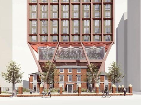
Why can’t we build above buildings which, for good or bad reasons, we are intent on keeping forever? It is obviously technically at least in the United Kingdom, highly controversial. A proposal to build above a listed building in the city of Birmingham provoked news stories and comment in national media, not just the architectural magazines.
The Architects’ Journal reported the issue succinctly: “Proposals for 80 Broad Street, submitted on behalf of developers HJB, feature a cantilevered residential tower floating above the former Royal Orthopaedic Hospital. If approved, the proposals for the 0.157-hectare site would see 300 one- and two-bed apartments built above the building, which has lain empty since 2020.
“The project is set to include 1,117 square meters of flexible community space, 750 square meters of new public realm and a 566-square-meter viewing platform with café and exhibition area. Residents would also have access to a rooftop space and 300 parking spaces for cars. Marrons’ design has divided opinion. Heritage campaign groups, including Historic Buildings & Places have called on Birmingham City Council to reject the scheme, due to its potential impact on the Grade II-listed former hospital building, Islington Villa.
“While the scheme is set to bring Islington Villa back into use, the charity described the development as ‘outrageous’ in a post on X (formerly Twitter) and said it would set a terrible precedent for listed buildings within the city.” The AJ quoted Prosocial Place, a research and design unit, saying: “Greedy idea that needs to be knocked back. It’s just big; not clever. To create high-density ‘liveable’ cities, we need density shared with other attributes like light and quality public realm. This is, and will be
A new light court was needed to convert New York’s 180 Water from office to residential.
Paul Finch
perceived as ‘cramming’—never a quality place.”
Planning documents say Islington Villa was last in use as a bar, restaurant and nightclub before its closure in 2020.
Marrons described it as having fallen into “disrepair.” The site was previously home to the Islington Glassworks, between 1816 and 1842, before becoming a hospital.
The AJ quotes Charlotte El Hakiem, planning director at Marrons, saying: “Broad Street is undergoing a period of intense regeneration, with the overriding vision of creating a vibrant residential neighborhood, so we are extremely pleased to unveil plans to transform a beautiful Georgian-style building on under-utilized brownfield land.
“The proposal takes a distinctive and innovative approach that allows for the retention and careful repurposing of a Grade II-listed building to bring it
back into public use, while simultaneously creating a striking 42-story landmark tower that contains much-needed housing to accommodate the city’s ever-growing population.”
This is a fair point: net inward migration to the United Kingdom is currently running at more than 700,000 people a year, and government predictions suggest the country will need to be building the equivalent of five times the number of homes in Birmingham by the year 2036 in order to keep supply in balance with demand.
But leaving aside the need for a pragmatic approach to housing supply, sadly lacking for the past 40 years, there is a strong case for supporting the in-principle argument made in respect of building above existing stock. The late, great architect Will Alsop described this approach to planning, heritage and new-build as “Knock Nothing Down”—prompted by what he saw as the increasing aversion to new architecture if it involved any sort of demolition, not just of heritage buildings.
That trend has accelerated as a result of concerns about the wastage of embodied carbon as a result of
demolition, and has generated increased interest in retrofit as a strategy to be considered before an automatic decision to demolish and rebuild. In what carbon activists see as a test case, the government recently overruled Westminster Council, the Greater London Authority, and an independent inspector who conducted a public inquiry, to block retailer Marks and Spencer demolishing one of its Oxford Street stores in order to generate new retail space and offices.
That government decision has been challenged successfully in the courts, so a rethink is going on, but the case has shaken the development industry in London, not least because of the implication that site intensification may become increasingly difficult. Intensification and building for longevity are carbon-virtuous, so this debate will run and run.
In the Birmingham example, intensification is the key to the project— and you might have thought that since the historic building is being brought back into use, it would have been welcomed by those who claim to support heritage, but not a bit of it. Some people are never satisfied.
TAIPEI, CHINA
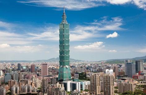
How Taipei 101 Really Survived the Earthquake
On 3 April 2024, Taiwan experienced a 7.4-magnitude earthquake—the strongest to hit the island in 25 years— causing considerable damage across the island. Many eyes turned to the iconic Taipei 101, once the world’s tallest building, to marvel at how it survived unscathed.
The media—from CNN to the Washington Post—circulated a great deal of misinformation claiming that the tuned mass damper (TMD) was responsible for saving Taipei 101 from catastrophe during the earthquake and thereby saving multiple lives. It is
Proposals for 80 Broad Street feature a residential tower above a listed existing building.
Mark Matthews & Dennis Poon
perhaps understandable, in our visual age, why journalists fell into this inaccuracy: the TMD—affectionately dubbed “Damper Baby” by tourists— is a highly photogenic golden orb. But the primary purpose of the TMD is to counteract the skyscraper’s movements caused by high winds and typhoons— not earthquakes.
Designed and built by Canadian company Motioneering, the TMD is a critical component intended to control undesirable building motion and ensure occupant comfort and safety, reducing building sway by up to 40 percent. A colossal steel pendulum weighing 660 metric tons, it is housed at the heart of the structure, anchored at the 92nd floor, and stabilized by viscous damping devices (VDDs) attached to the 87th floor.
In August 2015, the damper faced a significant challenge during Typhoon Soudelor, when wind gusts reached 233 km/h (145 mph). The pendulum moved out of phase with the building’s sway, effectively limiting tower movement and ensuring the occupants’ safety and comfort despite the extreme conditions.
Although the TMD’s primary design objective is not to mitigate seismic events, as part of the robust approach to engineering the tower Motioneering was required to establish exactly how the TMD would behave during an earthquake. To prevent the TMD from swinging precariously, the pendulum’s movement is limited to 1.5 meters in any direction by a steel “bumper pin” at the bottom of the TMD that is allowed to impact the inside diameter of a heavy “bumper ring.”
The bumper ring is stabilized by large seismic shock VDDs that absorb the impact loads. Therefore, during a seismic event, the damper effectively maintains its composure and “goes along for the ride.”
Taipei 101 was designed and built to resist seismic forces beyond local code at the time of its construction over 20 years ago. This is the primary reason that the 508-meter structure performed so well in the recent earthquake.
A New Magazine for a New Era at the Council CTBUH
As introduced on page 1, the mission of Vertical Urbanism is to advance discourse on sustainable urban growth globally, through insightful journalism, interdisciplinary perspectives and constructive dialogue. We engage with professionals, academics, and policymakers in the realm of citymaking by featuring diverse urban and technological perspectives.
Why launch a new publication? This initiative is part of a new leadership vision for a broader, more impactful organization. The Council on Tall Buildings formally added “Urban Habitat” to its name in 1976, as it became clearer that the organization needed to embrace the wider urban context in which tall buildings are constructed. With the rapid changes that have rippled through cities in the intervening decades—to say nothing of the last few years—CTBUH is poised to respond to the wider cornucopia of urban issues, and reach out to, the wider community of urban citizens, which is of course growing daily. Still, “vertical urbanism” is not a new concept. We’ve been using the tagline “towards sustainable vertical urbanism” for many years, and have pioneered the Master of Tall Buildings and Vertical Urbanism (M.TBVU) program at the Illinois Institute of Technology (IIT).
We have gone through many iterations on the way to this concept, which we fully expect to continue to evolve. The CTBUH Board of Trustees, Advisory Group, and Leaders offered their support. We have had focus groups large and small, within the CTBUH membership and in the broader world of city-makers, and we think we have brought the best of those worlds together. And we’re not done yet. Expect to hear a lot more from us soon.
The tuned mass damper (TMD) is a golden orb suspended at the heart of Taipei 101.
Taipei 101—once the world’s tallest building—made headlines after surviving an earthquake.
Daniel Safarik & Will Hunter
OPINION
REAL CITIES OUTLAST REEL CATASTROPHES
MARC NORMAN
In Mike Davis’ 1999 book, The Ecology of Fear, one chapter stands out: “The Cinematic Destruction of Los Angeles.” In his meticulously maniacal way, he documents hundreds of instances throughout the history of cinema where the city is the victim, the foil, the trope, or the metaphor for everything from hubris to gullibility to greed. The impulse to make the city a character (or better yet a caricature) onto which we can exact punishments or retributions sells tickets and keeps the crowds coming back. Whether aliens (Independence Day), plagues of frogs (Magnolia), a zombie apocalypse (28 Days Later), or a wide range of climatological calamities (Day After Tomorrow), the city is done for, spectacularly, over and over again. Of course, cities are not characters, but complex organisms. The imagined destructions that stir our imaginations and elicit excitement need density of people and buildings, interesting, iconic architecture to slam into or blast, and complex infrastructures to tangle and upend. Cinematic disaster needs pedestrians and office workers and people sitting glibly in cafés idly sipping Americanos, or lost in the rapture of a packed outdoor illicit rave (Matrix Reloaded), oblivious of the actual rapture descending upon them, or dancing in anticipation of it (Independence Day). Only the best cities get destroyed. That said, these destructions are what the people want, but why? The imposition of comeuppance seems baked into the way many people see and talk about cities and the films are a manifestation of this. Whether it is the notion of density and teeming humanity or
the messy complexity, cities seem to lend themselves to scorn.
It is not just Los Angeles; London, San Francisco, and New York have definitely come in for more than their fair share of creative destruction. It also isn’t just cinematic. After the 1989 Loma Prieta Earthquake editorials started appearing about why the city of Los Angeles was ever there in the first place. That’s right, somehow 200 years of modern history and close to four million souls should have known never to be there in the first place and deserved, somehow, their fate. Ditto for New Orleans after Hurricane Katrina, Mexico City after its big earthquake and London post-Brexit. Normally secular, rational people get that old-time religion and see the presence of an angry, Old Testament God ready to exact punishment.
Declaring cities over, or non-viable, or ripe to be abandoned, gained new steam after the start of the COVID crisis. San Francisco was over; in a doom loop. New York was a hell-hole that newly freed workers finally got to leave for greener, suburban pastures. Chinese cities were over and London was somehow obsolete because we had Zoom!
As with previous post-Cassandra moments, we are seeing our cities coming back, certainly with issues, but also with vigor. This year New York will exceed 60
million tourists, surpassing the prepandemic mark. London’s economy has rebounded and grown above prepandemic levels. San Francisco has its problems but is also the undisputed heart of the exploding AI economy. Dubai, seen as unsustainable, notched a win as having one of the fastest growth rates of any city. This history, not so well covered in cinema, but ripe with real-world examples over millennia is what is interesting to me. What is the special sauce that creates the possibility for renewal in the face of catastrophic events, whether humanor heaven-made? Worse than any alien invasion, the internal combustion engine and the shipping container were threats that truly threatened cities. That’s a big budget movie I’d like to see. Watch the opening credits of West Side Story or the setting of On the Waterfront. What is revealed is a New York City whose raison d’etre was its port, the manufacturing it produced and the trade it trafficked in. Same with San Francisco.
The shift to deepwater ports was painful and a true existential threat, but in the wreckage and the rebuilding of the next act were repurposed waterfronts, counter-cultural revolutions and a shift to a knowledge economy that generates more GDP than most countries. On the cultural front, one might also argue that density, cohabitation and mixing are the gifts that keep giving. As we continue to climb out of pandemic disruptions and the existential crises that gripped our largest and most dynamic cities, expect a rash of GGIladen, city-destroying spectacles. Watch them, and when you leave the theater, be sure to wade into the crowds packing the cafés and populating the raves.
CHINESE URBANISM FALTERS
China’s rapid urbanization has been a modern marvel, but as its economy slows, cracks are emerging in its model of urban development, writes Austin Williams.
In 1976, the year that Chairman Mao died, China was just 17 percent urban. Today that figure is fast approaching 68 percent, with new cities, large towns, metropolitan development, and urban expansion evident everywhere.
The banks of Pudong to the east of Shanghai’s Huangpu River for example, were occupied by smokestack factories and small agricultural holdings until the 1990s. Now this vast area is home to multinational corporate headquarters housed in some of the tallest buildings in the world, free trade areas, technology innovation centers, and new regional city hubs, as well as being the architectural backdrop to a million selfies from the other side of the river.
Of course, China has always had to play catch-up with the West from a very low baseline. Indeed, China’s level of urbanization today, 67 percent, is the
same as that of the West back in 1976. So, while it appears to have caught up with the elite group of developed nations, the west hasn’t stood still and is now roughly 82 percent urbanized. The hare and the tortoise game continues. China still has a long way to go, but it’s getting there.
Although it still lags behind, the fact is that Chinese cities have emerged at a speed never before seen in human history. Back in 1976, there were 198 cities in the entire country and today there are 707 —17 of which are megacities (with over 20 million people)—and the intention is that there will be 900 sizable cities by 2025. Some of the data coming out of China is disputed, and many statistics need to be taken with a heavy dose of salt, but it is unquestionable that China is a country transformed. Within a generation or two, it has effectively metamorphosed from a rural economy of peasant subsistence farming to the second-largest economy in the world. Its GDP is now two-thirds the size of America’s and equal to that of Germany, Japan, India, and the United Kingdom combined.
But whereas the slow organic development of the western world has
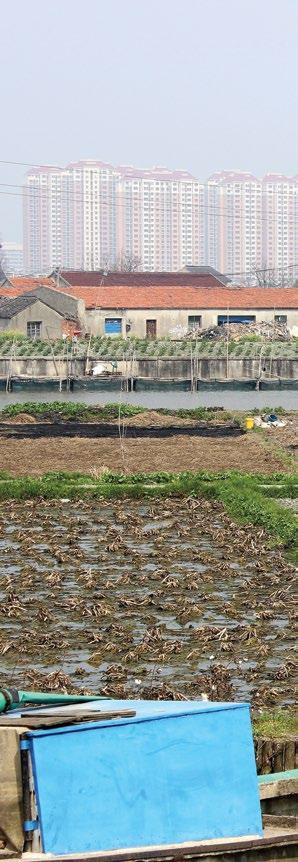
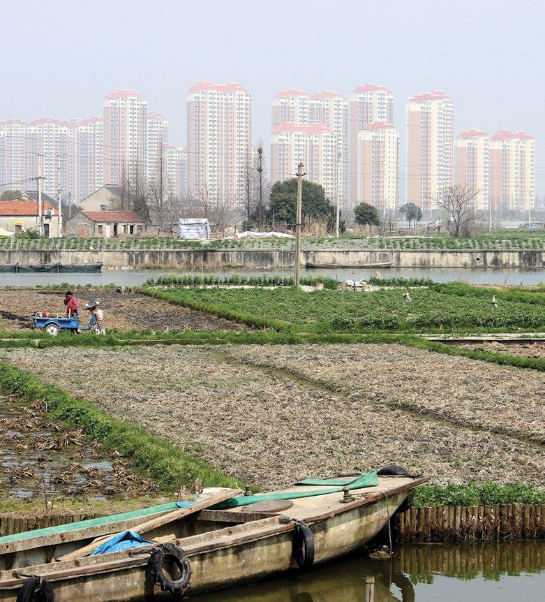
This image— Where towers meet rural: Jiangsu Province.
taken centuries to mature, China’s rapid, and in some situations, forced development has led to a number of problems, some of which are only recently coming to light. These developmental issues have not been helped by the external economic shocks caused by the 2008 recession, and the trauma of China’s own internal COVID lockdown. Actually, the sense of inevitable, permanent growth has taken a bit of a knock in recent years.
The economic slowdown, the potential collapse of the construction sector and the problems of rural under-development are just some of the issues now beginning to surface. The repercussions of these economic woes on families, as well as the resulting pressures on wider society, are leading to personal tragedy, community anxiety and potential unrest. They will also have ripples far beyond the borders of China itself.
Economy
Inefficient industrial practices in China have often been propped up by the state, but the recent tensions evident in the economy seem to have generated an existential threat
to China’s sense of uninterrupted growth and material development.
Migrant labor accounts for around 20 percent of the total population and 35 percent of the working population: that’s 300 million people in the unregulated economy, working long hours, often unprotected by labor rights, lacking permanent residency in their place of work, and earning a pittance. These people migrate from inland poverty, often remote countryside, to find work in the factories in China’s southeastern coastal manufacturing centers or larger inland cities. The influential China Labour Bulletin suggests that in the last few years, conditions have deteriorated for migrant workers in major cities such as Beijing, Shanghai, Guangzhou, and Shenzhen, and therefore fewer migrants are bothering to turn up. Instead, they are taking their chance looking for alternative sources of income, away from the extremes of exploitative manufacturing in cities far away, and back-breaking agriculture at home.
This is a double-edged sword for China. On one hand the government has been encouraging infrastructural
development in rural areas to encourage migrants to remain in order to prevent villages and towns from emptying out. Since 2011, through its rural revitalization program, it has been spending huge amounts of money and providing statesponsored architectural commissions promoting rural areas as attractive places to live. Of course, it is cheaper to keep people local than to further urbanize millions of people into new urban agglomerations, but the bigger ambition is to grow more localized economies away from the current centers of production, to make China more resilient to shocks and to develop a loyalty to regions. Conversely, reducing the seasonal glut of cheap workers to the factories and workshops of the eastern seaboard has proven to be problematic for the labor-intensive manufacturing sector in established small- and large-scale industries. As lower-skilled workers refuse to return, and wages rise, some companies are offshoring to more profitable areas.
Construction
A similar but potentially more serious issue affects China’s construction sector.
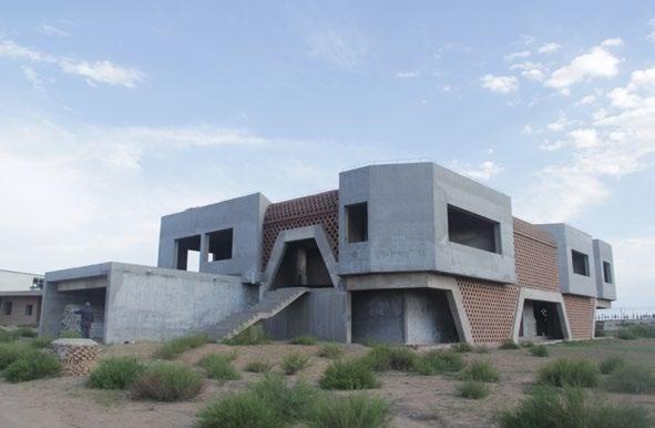
Right—An example of an expensive folly, this one designed for Ai Wei Wei.
AUSTIN WILLIAMS
Construction represents around 7 percent of GDP (UK = 7 percent, USA = 4.5 percent) but its real estate market is over 30 percent of GDP. Famously, in 1998, the UK government announced that it was going to build 4.4 million new homes by 2016, an ambitious 20-year goal that it signally failed to reach, whereas China completed that many new homes in the first eight months of every year since 2012. This housing miracle (or dangerous bubble, depending on your interpretation) is five times the rate of contemporary US residential completions, but in reality, many remain empty. Housing is often allocated according to central party diktat, not need, and many of the investors in real estate are beginning to realize that their property portfolios are built on sand, requiring the state to prop them up or go to the wall.
In his book Making the Modern World, environmental scientist Vaclav Smil revealed that China had used more concrete between 2011 and 2013, than America had used over the entire 20th century. Buildings, infrastructure, railways, cities; these were often built regardless of environmental, aesthetic, and economic consequences.
President Xi Jinping intimated that he was cooling China’s building frenzy when he demanded “no more weird buildings,” meaning that he intended to curtail the particular fever of Western-inspired, architecturally flamboyant, extortionate construction projects that were being commissioned by local Party officials to attract inward investment to their fiefdoms, coincidentally earning promotions in the process.
The harsh reality of China’s urban expansion relies on local Party administrations taking agricultural land out of productive use, paying belowmarket compensation, redeploying the agricultural workers who lived there, and selling the development asset at a profit. In a flagrant example of doubleaccounting, the Financial Times reports that more than half of the US$316 billion in residential property plot sales by local Chinese authorities in 2022 were made to investment companies: the very
institutions that borrow money to finance real estate development in the first place. Like the subprime scandal before it, these Ponzi schemes have the potential for devastating local economies, and the global economy is not immune from shockwaves.
Today, more than 41.5 percent of urban households own two or more properties, with an average urban homeownership of 1.5 properties. Many of these tend to be investments in the rental sector or the speculative market, both of which are being hit by the collapse of the housing market triggered by the failure of the country’s second-largest real estate developer, Evergrande. While many thought that the state would back it financially, it actually allowed Evergrande to default with debts of over US$300 billion. In China, it seems, no one is too big to fail, especially if they threaten the stability of the country and undermine the legitimacy of the Party.
The reverberations of Evergrande’s collapse are yet to be felt in the West, as the Party is trying to control the implications, but already inward investors are having to write off huge sums. It has been reported that UKbased bank HSBC suffered an 80 percent fall in share profits as its stake in China’s Bank of Communications took a hit from the nervous construction sector. Further repercussions are yet to surface. The legacy of exposure to such a major construction market failure will be hard to contain, even for China.
Innovation Deficit
The Chinese economic miracle of the last 20 years or so has relied on major infrastructure spending and cheap labor to massage its GDP figures. But due to the housing crisis, the industrial slowdown, low consumer spending, and labor shortages in some industries, China’s private sector is feeling the pinch. Oxford Economics predicts stagnant growth, impacting on overall profitability in manufacturing, slowing investment in infrastructure— domestically and internationally—and giving a boost to the state-owned sector over private enterprise.
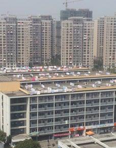
Right— A
public library, in Ordos, Inner Mongolia, designed to look like bookends.
This latter point will tend to reinforce the tendency of the last five years or so, for private business to shrink, or be restrained, while the Party machinery consolidates its authority.
The ruling Party—by definition, “the state”—has portrayed itself as the cornerstone of China’s economic stability since China embraced capitalism and opened up to foreign investment in the 1980s. While the private sector in China has led the way in innovation, the Party structure demands that key decisionmaking control rests with the central Party machine. As economic difficulties begin to grow in China, so the state sector has to be seen to be solving them. Currently, the state-owned sector exceeds private company ownership by some 40 percent, and this seems to be increasing, with many independent private firms forced to toe the line. President Xi sees himself as the embodiment of social stability, balancing the hidden hand of the market with the iron fist of the state. As far as political hardliners are concerned, the autonomous decision-making ability of the private sector is inherently destabilizing for Communist Party rule.
The latest problem to plague the Chinese economy is its historical reliance on cheap labor to the detriment of providing meaningful education, development and training to ordinary people. Unsurprisingly, with such a vast rural population (almost 500 million live in the countryside), and many menial migrant workers in urban areas, the country has one of the lowest levels of education of any country in the world. Stanford professor Scott Rozelle says, “For all of its investment in physical infrastructure, China failed to invest enough in its people” and its unskilled, rural and disenfranchised populations— almost 800 million people—are currently not up to the task of competing in an automated world.
For all China’s statistical advances in urbanization, some of the clear gains
of urban development have not filtered through to the majority of society. These problems might have been foreseen in more slowly evolving circumstances. For example, in its haste to build modern cities, central business districts, efficient road and rail networks, it didn’t find time to build in any green space. It is now having to demolish some of its built environment in order to insert some humane environment. Of course, in order to build New York’s Central Park, demolition and relocations also had to take place, but China’s more contemporary ability to ride roughshod over lives and livelihoods makes its environmental credentials seem less benign, somehow.
It is true that China has lifted 400 million people out of poverty, but there are still vast numbers of people living in penury in rural areas, and millions of disenfranchised workers who are denied access to education and resources living in China’s brand-new cities. China is emerging onto the urban world stage, but there is still a lot of catching up to do. Austin Williams’ book China’s Urban Revolution: Understanding Chinese Eco-Cities is published by Bloomsbury Academic.
Below— Roof scene in Suzhou.
BOTH:
IS BUILDING TALL A GOOD INVESTMENT FOR SOCIETY’S CARBON?
Yes, if design and planning balance environmental impact with societal benefits, argues Arup’s Chris Edgington.
Tall buildings epitomize the link between society and its built environment. They are a visible symbol of the values of the communities in which they operate. Built to be seen from afar, tall buildings send a powerful and near-permanent message of a place. Often, they showcase economic dynamism, serve as centers of excellence, and act as hubs of business and talent.
And yet, tall buildings can be divisive. Their interpretation can stray far from that intended by their authors. They can present well-considered architectural placemaking and knit into the fabric of a society that welcomes them and understands their contribution. But, if executed poorly, they can be soulless and in stark contrast with the neighborhoods they inhabit, whose sole economic contribution was to make money for their now-absent original investors.
Increasingly, carbon emissions are at the crux of these debates. Building tall undoubtedly requires substantial use of materials, meaning its value must justify
this cost. As an industry, we must consider how we judge what is an appropriate use of the planet’s precious resources, balancing numerous environmental, economic and societal factors to agree, as a supply chain, on making change for the better.
It is often the case that for a given usable floor area, a tall building will represent a greater investment of material and energy than a shorter counterpart. With increasing height comes additional effort required to combat the forces of wind and gravity, often with the side effect of increased complexity and mass to resolve. It is therefore natural to
assume that tall buildings are a greater drain on resources than shorter ones of the same overall floor area.
In many ways, this is true. However, it is important to distinguish between the increasing effects of height and the impact of building at scale. Providing large numbers of people with comfortable conditions to assemble, in any building— no matter its height—requires sizable investment of material and embodied carbon. It also means increased operational carbon and use of energy for heating, air conditioning and lighting. And there will inevitably be an impact on infrastructure, as huge numbers of people travel to one location. This is often viewed as balancing out when compared to the cost of economic activity expected to be undertaken in these locations.
Nonetheless, tall buildings carry unique challenges which must be designed for. Not only must they lift and move people over their greater height, but they also move energy for
heating and cooling over the same distances, and require additional material associated with their physics.
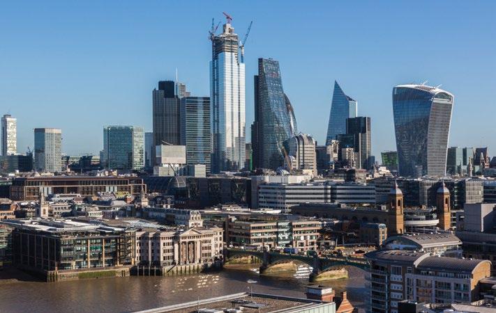
There are significant wider societal impacts too. Taller buildings not only impact their immediate environment, but also their townscape. In London, for example, contrasting the skyline in the year 2000 with today reveals significant change. Across Canary Wharf and the City, whole neighborhoods exist based on enclaves of tall buildings, used for both commercial and residential space. These buildings form the backdrop to many aspects of life across the city, and can be seen from some distance.
Not all who observe these buildings and neighborhoods welcome them; where buildings are poorly integrated into the locale, they can detract substantially from amenities and historical landmarks.
Tall buildings also have significant physical impacts on their neighborhoods. They create overshadowing, local wind effects, and can impact local air quality in
operation. Their construction is also a carbon-intensive and disruptive activity.
Finding the Balance
One might question why, when faced with these headwinds, society would permit development to occur. The answer here lies in understanding that the impacts can be mitigated through careful design and meaningful engagement between stakeholders. To permit no development would cause significant issues of its own.
In constrained urban areas, demand for housing or commercial space can often outstrip supply. Building tall can be part of a wider plan to address local needs, providing the backdrop for the activity on which society depends. It is therefore crucial that a balance is struck between society’s needs and those whose money pays for the development. This involves considering the long-term role of a building; once a building exists, who will pay if it needs investment? And what will happen as it ages?
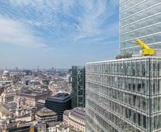
Right— skyline, showing the “Walkie-Talkie” and the Shard.
PAUL CARSTAIRS / ARUP
Above—London has transformed its skyline with distinctive tall buildings.
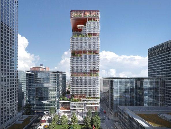
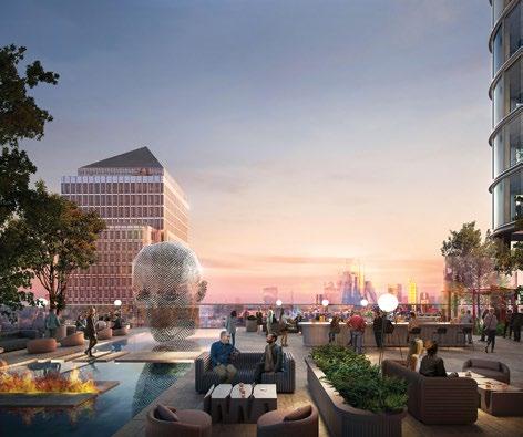
8 Canada Square, London
Recent launches of the imaginative plans at Canary Wharf, where the Foster + Partners-designed 8 Canada Square is to be reinvented by Kohn Pedersen Fox following the departure of HSBC into the City of London, show that it is absolutely possible to give buildings a second (and later, third) lease of life.
Buildings are a part of the fabric of society, retaining their appeal as part of a wider ecosystem. If the wider public space is not attractive, the buildings around it are also likely to become less attractive to occupiers. Avoiding managed decline of areas cannot, therefore, be an afterthought.
To answer these questions and judge what an appropriate use of society’s carbon is, collaboration is required. We must involve planners, economists, architects and placemakers, as well as consider market forces and any possible scrutiny a plan is likely to encourage.
Prioritizing Carbon Emissions
Carbon emissions must be central to any development decisions. Buildings account for 37 percent of global energyrelated carbon emissions, meaning any conversation on whether to build tall must focus on its carbon impact.
To do this first requires we examine two categories of carbon emissions associated with the built environment:
Operational carbon: Carbon emissions from energy associated with the building in use, e.g. heating, cooling, ventilation, lighting, occupier power, lifts.
The UK electricity grid has substantially increased renewable energy generation over the past 15 years, and has a target of becoming 100 percent zero-carbon by 2050. Recognizing that there are limited options to decarbonize buildings using combustion-based heating, we are moving towards the electrification of heat. On the basis that buildings operate free of fossil fuels, the
Left—KPF’s plans at 8 Canada Square to renew the HSBC tower in London’s Canary Wharf.
KIASM
carbon emissions associated with their energy use will diminish with the grid’s decarbonization.
Embodied carbon: The carbon emitted during the building’s lifecycle, from the extraction of raw materials through to their re-use and disposal.
The materials from which we construct buildings, and the finishes and equipment that we put in buildings, all have an associated carbon impact. Material used in the construction process—steel, concrete, glass, and aluminum—all must be created, transported to site and put into place. Based on recent Arup project data, we observe that the upfront embodied carbon associated with buildings makes up over half of the lifetime emissions of a building assessed over a 60-year period.
Carbon Optioneering
Armed with this understanding of the importance of embodied carbon, we can see that frequent demolition and rebuild cycles cannot be sustained. We need to ensure that we avoid “single-use,” in the
same way we now avoid plastic straws in restaurants. We must consider how existing buildings could be refreshed or adapted, rather than assuming we should knock them down and replace them.
We are starting to see some genuinely exciting proposals that embrace and transform existing buildings—stitching a tall building into existing low-rise development. These schemes obviously seek to make good use of the embodied carbon in the existing building, avoiding unnecessary demolition.
That said, it is possible that the complexities in building over an existing building can strain the overall carbon budget. Older buildings will likely have a longer column grid (a nod to a past when avoiding columns was worth increasing steel-weight for), constraining the ability of structural engineers to build a modern low-carbon structure directly overhead. Lateral thinking and critical assessment of the overall carbon impact is needed to help ensure that the most appropriate option is taken forward.
“Carbon optioneering”—the process of comparing different design options to
reduce carbon emissions—is a new phrase, but one that all major projects seeking planning permission in London must now start with.
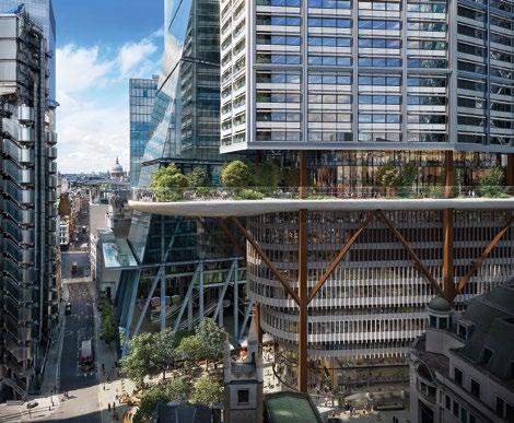
8 Bishopsgate, London
The 51-story office tower at 8 Bishopsgate in London gives reason for optimism. This beautiful building was designed and procured before carbon accounting was a discipline, having been started in 2013, with work on site beginning in 2019. For this scheme:
The design team delivered a structurally lean building, because it made good economic and environmental sense.
The architect spearheaded a design palette that celebrated self-finished and natural materials, eschewing unnecessary carbon associated with drylining.
The building services and façade strategy used active façade shading to limit heat gains and to right-size the air conditioning and plant systems.
The construction manager and trade contractor supply chain engaged with the client’s drivers for low embodied carbon,
Left—The proposals for 8 Canada Square introduce significant shared spaces.
helping to quantify the carbon impact of the procured material. The as-built upfront embodied carbon of this building, assessed against the RICS v1 methodology, was 808 kg CO2/m2, a metric that compares well against much shorter buildings and is below the GLA (Greater London Authority) Current Office benchmark.
If a motivated team and its good design can collaborate to achieve a performance like this without the benefit of carbon as a decision making tool, it stands to reason that—with greater engagement throughout the project value chain, starting with clients and end users, threading through design and specification, the supply chain and into construction—in the future we will be able to deliver meaningful improvements against even this performance.
There will remain compromises to navigate. We must balance the speed of construction and its relation to cost, understanding that some decisions may lead to higher operational carbon but with lower embodied carbon, for example. However, combined with the increasing carbon literacy of municipalities and the professional teams that work in them, this all points to a future where “tall building construction” does not need to be a “dirty phrase.”
Acting as One Value Chain
To implement change to the decisionmaking process, and design, of tall buildings, we need all stakeholders to share common goals. When the whole value chain cares, the right action is taken. Encouragingly, there is now significant interest and investment in reducing carbon emissions from occupiers, architects and the public.
Major tenants look not only for high performance against well-known assessment frameworks—BREEAM,
WELL, Wiredscore, etc., but also want to understand the carbon impact of buildings. Building carbon impacts can be assessed in two categories—embodied and operational carbon. It is only recently that embodied carbon assessments have become part of the development lexicon, effectively creating a new specialist discipline. Design teams now use embodied carbon as an accounting metric and decision-making tool—automatically helping to drive down construction waste before proposals make it to planning.
Built environment professionals are accustomed to assessing operational energy and carbon, and with assessment and rating schemes like NABERs, we are finally seeing a light shone on the so-called “performance gap,” where buildings have not always performed as their specifiers might have imagined.
As designers, we frequently now need to assess both the operational and embodied carbon impacts of proposals, seeking to find objectively the best outcome overall. Approaching design through a whole-life carbon lens is key—weighing up the embodied carbon directly influenced by structural engineers, with the operational carbon more associated with building services. Getting this right is non-trivial; where we deploy a reusable material like steel for a building, we know that it will be reused should the need arise.
Making the Decision to Build Tall
The additional scrutiny being applied to how society approaches tall buildings is, of course, justified. These buildings have substantial impacts on their communities, economically, visually and environmentally.
As such, developers must consider every possible impact and perspective in their plans. It is therefore worth considering tall buildings within their wider societal context, applying the same strict decision-making criteria afforded to any building of scale.
By not automatically assuming tall buildings will have a negative impact, we open ground for more creative and efficient plans that can genuinely contribute to the societies in which they co-exist.
Right—
The 51-story office tower at 8 Bishopsgate in London, designed by Wilkinson Eyre.
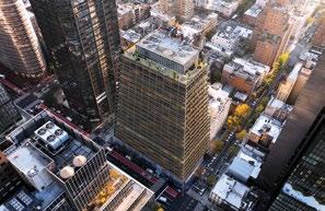
NORMAN FOSTER: MY TALL BUILDINGS
For our launch issue, Vertical Urbanism invited the venerated British architect of some of the world’s most iconic towers to reflect on how his approach to tall buildings has evolved over the last half-century.
My fascination with the tall building began with a design assignment in the Master’s Class of 1962, at the Yale University School of Architecture. Despite a previous five years as a student, it was the first time I had been challenged by a tower, and I felt the need to go back to first principles, starting with the structure. I asked the Dean, Paul Rudolph, if he could find me an engineer to work with. This was an unheard-of proposition. The cult of Yale, like so many schools, was that the architect designed a building and then, afterwards, the engineer would make it stand up. To the credit of Rudolph, despite his beliefs, he found me an engineer who would work alongside me.
As we started a dialogue together, it quickly became obvious why every tall
Far left Norman Foster’s student project at Yale.
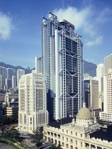
Left and left below—Hong Kong and Shanghai Bank Headquarters, Hong Kong.
Right and right below— The Hearst Tower, New York City.
tower from the birth of the high-rise onwards had a central core. It combined structure with vertical circulation, bathrooms and mechanical services for heating and cooling. It was so logical that it was perhaps obvious why it had never been questioned. However, the occupants in such a concept are forced to occupy a restricted perimeter strip around the core with one-way views outwards. What if, I argued, the core were fragmented and its separate elements placed alongside flexible, open, loft-like floors, with cross views on the two long sides? This led to a design which the later Dean, Robert Stern, would suggest was the genesis of our tower in Hong Kong for the Hong Kong and Shanghai Bank, designed in 1979 and opened six years later.
This project was the first in a succession of towers that have effectively reinvented the skyscraper by exploring alternatives to the historic central-core model. In the 2023 exhibition of our works in the Pompidou Centre, I lined models of these diverse towers next to the long window wall—a play on the skyline of Paris, visible in the distance.
The visual dynamic of clusters of tall towers and the cities that generate them are inseparable from the dramatic profiles of their skylines. However, coming down to earth, the connection of a tower with the urban fabric at its base is critically important. It is an opportunity for the private world within the tower to engage with the local community—to give back some social benefit to the city that is the host. For
CHUCK CHOI
example, the Hong Kong tower is elevated above the ground to provide a significant public space as a shortcut under the building. It acts as an extension of the park that fronts the headquarters and, in a dense city, provides valuable breathing space.
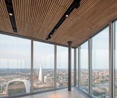
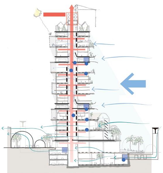
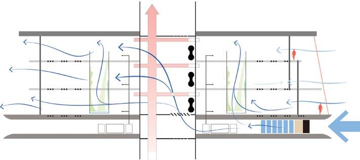
The Commerzbank Tower in Frankfurt similarly engages with the public domain by providing a public route through its base. This urban interchange features a restaurant open to the public and bank employees alike. A low-rise podium knits into the scale of the surrounding streetscape.
The Hearst Tower in New York not only recycles a historic 1928 Art Deco base, but brings the sidewalk to life by returning traditional uses to the ground level. Hollowed out from
within, it creates the equivalent of a town square, bringing together diverse groups through restaurants, exhibitions and gathering spaces. The identity of the Hearst Tower is the expression of its structure. Here the diagrid of recycled steel saves some 20 percent of structural weight compared with a conventional structure.
Still in New York, the cantilevered structure of the JPMorgan Chase World Headquarters, in Midtown Manhattan, doubles the amount of public space at its base compared with its predecessor.
Our evolution of the tall tower has a sustainability agenda. For example, the Hong Kong Bank broke with the conventional glass box by introducing external shading to reduce the solar gain and energy demand. The
Commerzbank Tower that followed was a high-rise “first,” with its opening façade that creates a climate-controlled, naturally ventilated interior— combining wellness with lower energy consumption. All the skyscrapers that followed, including the Hearst Tower, were marked by enhanced natural ventilation—in some instances double the code standards—to create an exceptional indoor air quality. Here the health of the occupants overlaps with that of the planet.
On the subject of the environment, I am sometimes challenged by the question of “how can a tall tower ever be sustainable?”
My answer is to show them a recent map of the East Coast of America prepared by two researchers from the
Left and above— Manhattan’s JPMorgan Chase World Headquarters.
Above left— Commerzbank, Frankfurt: “the world’s first ecological office tower.”
“New York is an island of relative sustainability that is inseparable from its dense verticality”
University of California, Berkeley. It is color-coded to show, area by area, the carbon footprint, with red showing the extreme high and dark green marking the lowest.
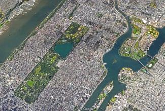
At first glance, it is dominantly red, but on closer examination there is a dark green spot marking Manhattan, a true vertical city standing out from its background of suburban sprawl. New York, for a variety of reasons, especially for its walkability and lack of dependence on the car-borne commute, is an island of relative sustainability that is inseparable from its dense verticality.
The most sustainable can also be the most desirable. New York topped the sixth annual list of the “Best Cities in the World,” released by Time Out in January 2024.
Left—The JP Morgan Chase skyscraper will be New York City’s largest all-electric tower with net-zero operational emissions.
ESSAY THE CASE FOR OPEN CITIES
Cities must accept that good density is by nature disorderly and that embracing an open system—porous borders, incomplete forms, and evolving narratives—is critical to the vitality of urban life, argues Richard Sennett.
The cities everyone wants to live in should be clean and safe, possess efficient public services, be supported by a dynamic economy, provide cultural stimulation, and also do their best to heal society’s divisions of race, class, and ethnicity. These are not the cities we live in. Cities fail on all these counts due to government policy, irreparable social ills, and economic forces beyond local control. The city is not its own master.
Still, something has gone wrong— radically wrong—in our conception of what a city itself should be. We need to imagine just what a clean, safe, efficient, dynamic, stimulating, just city would look like concretely—we need those images to confront critically our masters with what they should be doing—and just this critical imagination of the city is weak.
This weakness is a particularly modern problem: the art of designing cities declined drastically in the middle of the 20th century. In saying this, I am propounding a paradox, for today’s planner has an arsenal of technological tools—from lighting to bridging and tunneling to materials for buildings—that urbanists even a hundred years ago could not begin to imagine: we have more resources to use than in the past, but resources we don’t use very creatively.
This paradox can be traced to one big fault: the over-determination of both the city’s visual forms and its social functions. The technologies that make experiment possible have been subordinated to a regime of power that wants order and control. Urbanists, globally, anticipated the “control freakery” of current planning law by a good half century; in the grip of rigid images and precise delineations, the urban imagination lost vitality. In particular, what’s missing in modern urbanism is a sense of time—not time looking backward nostalgically, but forward-looking time, the city understood as process, its imagery changing through use, an urban imagination formed by anticipation, friendly to surprise.
A portent of the freezing of the imagination of cities appeared in Le Corbusier’s Plan Voisin in the mid-1920s for Paris. The architect conceived of replacing a large swath of the historic center of Paris with uniform, X-shaped buildings; public life on the ground plane of the street would be eliminated; the use of all buildings would be coordinated by a single masterplan. Not only is Corbusier’s architecture a kind of industrial manufacture of buildings; he tried in the Plan Voisin to destroy just those social elements of the city which produce
change in time, by eliminating unregulated life on the ground plane; instead, people live and work in isolation, higher up.
This dystopia became reality in various ways. The plan’s building type shaped public housing estates from Chicago to Moscow, which came to resemble warehouses for the poor. Corbusier’s intended destruction of vibrant street life was realized in suburban growth for the middle classes, with the replacement of high streets by monofunctional shopping malls, gated communities, and schools and hospitals built as isolated campuses. The proliferation of zoning regulations in the 20th century was unprecedented in the history of urban design, and this proliferation of rules and bureaucratic regulations has disabled local innovation and growth, frozen the city in time.
The Brittle City
The result of over-determination is what could be called the Brittle City. Modern urban environments decay much more quickly than urban fabric inherited from the past. As uses change, buildings are now destroyed rather than adapted; indeed, the over-specification of form and
function makes the modern urban environment peculiarly susceptible to decay. The average lifespan of new public housing in Britain is now 40 years; the average lifespan of new skyscrapers in New York is 35 years.
It might seem that the Brittle City would in fact stimulate urban growth, the new now more rapidly sweeping away the old, but again the facts argue against this view. In the United States, people flee decaying suburbs rather than reinvest in them; in Britain and on the Continent, as in America, “renewing” the inner city most often means displacing the people who have lived there before. “Growth” in an urban environment is a more complicated phenomenon than simple replacement of what existed before. Growth requires a dialogue between past and present; it is a matter of evolution rather than erasure.
This principle is as true socially as it is architecturally. The bonds of community cannot be conjured up in an instant, with a stroke of the planner’s pen; they too require time to develop. Today’s ways of building cities—segregating functions, homogenizing population, pre-empting the meaning of place through zoning and regulation—fail to provide communities the time in space needed for growth.
The Brittle City is a symptom. It represents a view of society itself as a closed system, a conception which dogged state socialism throughout the 20th century as much as it shaped bureaucratic capitalism. This view of society has two essential attributes: equilibrium and integration.
The closed system ruled by equilibrium derives from a pre-Keynesian idea of how markets work. It supposes something like a bottom line in which income and expenses balance. In state planning, information feedback loops and internal markets are meant to ensure that programs do not “over-commit,” do not “suck resources into a black hole”—such language is familiar to urban planners in the ways infrastructure resources for transport get allocated. The limits on doing any one thing really well are set by the fear of neglecting other tasks. In a
closed system, a little bit of everything happens all at once.
Second, a closed system is meant to be integrated. Ideally, every part of the system has a place in an overall design; the consequence of that ideal is to reject, to vomit out, experiences that stick out because they are contestatory or disorienting; things that “don’t fit” are diminished in value. The emphasis on integration puts an obvious bar on experiment. As the inventor of the computer icon, John Seely Brown, once remarked, every technological advance poses at the moment of its birth a threat of disruption and dysfunction to a larger system. The same threatening exceptions occur in the urban environment, threats that modern city planning has tried to forestall by accumulating a mountain of
Above—
Le Corbusier’s Plan Voisin for Paris would have destroyed the social elements of the city that produce change in time, by eliminating unregulated life on the ground plane.
F.L.C.
rules defining historical, architectural, economic, and social context—“context” being a polite but potent word in repressing anything that doesn’t fit in, context ensuring that nothing sticks out, offends, or challenges.
The sins of equilibrium and integration bedevil coherence, planning sins which crossed the line between state capitalism or state socialism, were committed by planners of education as much as planners of cities. The closed system betrays the 20th century bureaucrat’s horror of disorder.
The social contrast to the closed system is not the free market, nor is the alternative to the Brittle City a place ruled by developers. That opposition is in fact not what it seems. The cunning of neo-liberalism in general, and of Thatcherism in particular, was to speak the language of freedom while manipulating closed bureaucratic systems for private gain by an elite. Equally, in my experience as a planner, those developers in London, as in New York, who complain most loudly about zoning restrictions are all too adept in using these rules at the expense of communities.
The contrast to the closed system lies in a different kind of social system, which is open rather than closed, not in brute private enterprise. The characteristics of such an open system, explored below, are realized in an open city.
The Open System
The idea of an open city is not my own: credit for it belongs to the great urbanist Jane Jacobs, developed while arguing against the urban vision of Le Corbusier. She tried to understand what results when places become both dense and diverse, as in packed streets or squares, their functions both public and private; out of such conditions comes the unexpected encounter, the chance discovery, the innovation. Hers is a view reflected in the bon mot of English literary critic William Empson that “the arts result from overcrowding.”
Jacobs sought to define particular strategies for urban development, once a city is freed of the constraints of either
equilibrium or integration. These include encouraging quirky, jerry-built adaptations or additions to existing buildings, and encouraging uses of public spaces which don’t fit neatly together, such as putting an AIDS hospice square in the middle of a shopping street. In her view, big capitalism and powerful developers tend to favor homogeneity: determinate, predictable, and balanced in form; the role of the radical planner is therefore to champion dissonance. In her famous declaration, “If density and diversity give life, the life they breed is disorderly.” The open city feels like Naples; the closed city feels like Frankfurt.
For a long time, I dwelt in my own work, happily in Jacobs’ shadow— in both her enmity to the closed system (though the formal concept is mine, not hers) and her advocacy of complexity, diversity, and dissonance. Recently, in rereading her work, I’ve detected glints of something lurking beneath this stark contrast.
If Jacobs was the urban anarchist she was often said to be, then she was an anarchist of a peculiar sort, her spiritual ties closer to statesman Edmund Burke than to revolutionary Emma Goldman. She believed that in an open city, as in the natural world, social and visual forms mutate through chance variation; people can best absorb, participate, and adapt to change if it happens step-bylived-step. This is evolutionary urban time, the slow time needed for an urban culture to take root, then to foster, then to absorb chance and change. It is why Naples, Cairo, or New York’s Lower East Side, though resource-poor, still “work” in the sense people that care deeply about where they live. People live into these places, like nesting. Time breeds that attachment to place.
In my own thinking, I’ve wondered what kinds of visual forms might promote this experience of time. Can these attachments be designed by architects? Which designs might abet social relationships that endure just because they can evolve and mutate? The visual structuring of evolutionary
Above—
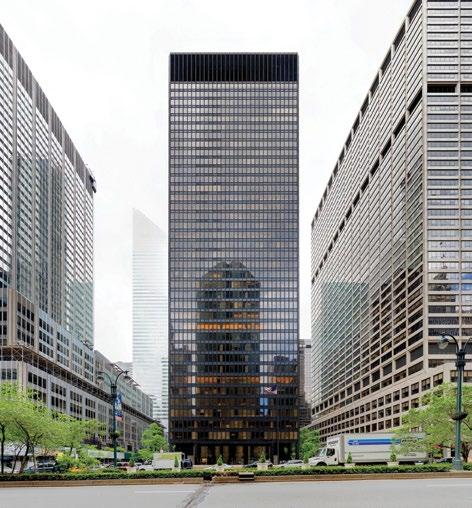
A gate in the Roman wall of Empuries, Spain, 1st century BCE. In ancient times, city walls functioned like cell membranes, both porous and resistant.
Right— Mies van der Rohe’s Seagram Building on Park Avenue is an example of large impervious plate glass panels creating a barrier, not a border.
time is a systemic property of the open city. To make this statement more concrete, I’ll conceptualize three systematic elements of an open city: passage territories; incomplete form; and development narratives.
Passage Territories
I’d like to describe in some detail the experience of passing through different territories of the city, both because that act of passage is how we know the city as a whole, and also because planners and architects have such difficulties designing the experience of passage from place to place. I’ll start with walls, which seem to be structures inhibiting passage, and then explore some of the ways edges of urban territory function like walls.
Walls
The wall would seem an unlikely choice; it is an urban construction which literally closes in a city. Until the invention of artillery, people sheltered behind walls when attacked; the gates in walls also served to regulate commerce coming into cities, often being the place in which taxes were collected. Massive medieval walls such as those surviving in Aix-en-Provence or in Rome furnish a perhaps misleading general picture; ancient Greek walls were lower and thinner. But we also misimagine how those medieval walls in themselves functioned.
Though they shut closed, they also served as sites for unregulated development in the city; houses were built on both sides of medieval town walls; informal markets selling blackmarket or untaxed goods sprung up nestled against them; the zone of the wall was where heretics, foreign exiles, and other misfits tended to gravitate, again far from the controls of the center. They were spaces which would have attracted the anarchic Jane Jacobs.
But they were also sites which might have suited her organic temperament. These walls functioned much like cell membranes, both porous and resistant. That dual function of the membrane is, I believe, an important principle for
visualizing more modern living urban forms. Whenever we construct a barrier, we have equally to make the barrier porous; the distinction between inside and outside has to be breachable, if not ambiguous.
The usual contemporary use of plate glass for walls doesn’t do this; true, on the ground plane you see what’s inside the building, but you can’t touch, smell, or hear anything within; the plates are usually rigidly fixed so that there is only one, regulated, entrance. The result is that nothing much develops on either side of these transparent walls; as in Mies van der Rohe’s Seagram Building in New York or Norman Foster’s London City Hall, there is dead space on both sides of the wall; life in the building does not accumulate here. By contrast, the 19th century architect Louis Sullivan used
much more primitive forms of plate glass more flexibly, as invitations to gather, to enter a building or to dwell at its edge; his plate glass panels function as porous walls. This contrast in plate glass design brings out one current failure of imagination in using a modern material so that it has a sociable effect.
The idea of a cellular wall, which is both resistant and porous, can be extended from single buildings to the zones at which the different communities of a city meet.
Borders
Ecologists like Stephen Gould draw our attention to an important distinction in the natural world, that between boundaries and borders. The boundary is an edge where things end; the border is an edge where different groups interact. In natural ecologies, borders are the places where organisms become more interactive, due to the meeting of different species or physical conditions. For instance, where the shoreline of a lake meets solid land is an active zone of exchange; here is where organisms find and feed off other organisms. The same is true of temperature layers within a lake: where layer meets layer defines the zone of the most intense biological activity. Not
surprisingly, it is also at the borderline where the work of natural selection is the most intense. Whereas the boundary is a guarded territory, as established by prides of lions or packs of wolves. The boundary establishes closure, whereas the border functions more like a medieval wall. The border is a liminal space.
In the realm of human culture, territories consist similarly of boundaries and borders—in cities, most simply, there is a contrast between gated communities and complex, open streets. But the distinction cuts deeper in urban planning. When we imagine where the life of a community is to be found, we usually look for it in the center of a community; when we want to strengthen community life, we try to intensify life at the center. The edge condition is seen to be more inert, and indeed modern planning practices, such as sealing the edges of communities with highways, create rigid boundaries, lacking any porosity. But neglect of the edge condition—boundarythinking, if you like—means that exchange between different racial, ethnic, or class communities is diminished. By privileging the center, we can thus weaken the complex interactions necessary to join up the different human groups the city contains.
As an example failure, some years ago, I was involved in plans for creating a market to serve the Latino community of Spanish Harlem in New York. This community, one of the city’s poorest, lies above 96th Street on Manhattan’s Upper East Side. Just below 96th Street, in an abrupt shift, lies one of the richest communities in the world, running from 96th down to 59th Street, comparable to Mayfair in London or the 7th Arrondissement in Paris. Ninety-sixth Street itself could function either as a boundary or a border. We planners chose to locate 20 blocks away, in the very center of the community, and to regard 96th Street as a dead edge, where nothing much happens. We chose wrongly. Had we located the market on that street, we might have encouraged activity which brought the rich and the poor into some daily commercial contact. Wiser planners
Above—
The historic form of Rome, shown here in the 18th century map by Giovanni Battista Nolli, exemplifies urban borders.
PUBLIC DOMAIN
have since learned from our mistake, and on the West Side of Manhattan sought to locate new community resources at the edges between communities, in order, as it were, to open the gates between different racial and economic communities. Our imagination of the importance of the center proved isolating, their understanding of the value of the edge and border has proved synthesizing.
I don’t mean to paint a Panglossian picture of such ventures in planning: opening-up borders means people of different strengths are exposed to competition. Borders can serve as tense rather than friendly sites of exchange— evoking some of the predatory quality of border conditions in natural ecologies. But taking that risk, which planners are now doing under more explosive conditions in Beirut and in Nicosia, is the only way in which we create conditions for a socially sustained collective life in cities; ultimately isolation is not a guarantor of civil order.
The porous wall and the edge as border create essential physical elements for an open system in cities. Both porous walls and borders create liminal space; that is, space at the limits of control, limits which permit the appearance of things, acts, and persons unforeseen, yet focused and sited. The biological psychologist Lionel Festinger once characterized such liminal spaces as defining the importance of “peripheral vision;” sociologically and urbanistically, these sites operate differently than those places which concentrate differences in a center; on the horizon, at the periphery, at the border, differences stand out, since one is aware one is crossing out of one territory into another.
Incomplete Form
This discussion of walls and borders leads logically to a second systematic characteristic of the open city: incomplete form. Incompleteness may seem the enemy of structure, but this is not the case. The designer needs to create physical forms of a particular sort, “incomplete” in a special way.
When we design a street, for instance, so that buildings are set back
The Pantheon in Rome is a self-referential object that co-exists in the urban fabric with less distinguished neighbors.
from a street wall, the space left open in front is not truly public space; instead the building has been withdrawn from the street. We know the practical consequences; people walking on a street tend to avoid these recessed spaces. It’s better planning if the building is brought forward, into the context of other buildings; though the building will become part of the urban fabric, some of its volumetric elements will now be incompletely disclosed. There is incompleteness in the perception of what the object is.
Incompleteness of form extends to the very context of buildings themselves. In classical Rome, Hadrian’s Pantheon coexisted with the less distinguished buildings which surrounded it in the urban fabric, though Hadrian’s architects conceived the Pantheon as a selfreferential object. We find the same co-existence in many other architectural monuments: St. Paul’s Cathedral in London, Rockefeller Center in New York, the Institut du Monde Arabe in Paris— all great works of architecture which stimulate building around themselves. It’s the fact of that stimulation, rather than the fact the buildings are of lesser quality, which counts in urban terms: the existence of one building is sited in
Above—
GABRIELLA
such a way that it encourages the growth of other buildings around it. And now the buildings acquire their specifically urban value by their relationship to each other; they become in time incomplete forms if considered alone, in themselves.
Incomplete form is most of all a kind of creative credo. In the plastic arts, it is conveyed in sculpture purposely left unfinished; in poetry, it is conveyed in, to use Wallace Stevens’ phrase, the “engineering of the fragment.” The architect Peter Eisenman has sought to evoke something of the same credo in the term “light architecture,” meaning an architecture planned so that it can be added to, or more importantly, revised internally in the course of time as the needs of habitation change.
This credo opposes the simple idea of replacement of form which characterizes the Brittle City, but it is a demanding opposition. For instance, when we try to convert office blocks to residential use—as many post-pandemic downtowns are seeking to do—we appreciate the challenges of repurposing overly determined built form.
Narratives of Development
Our work at UN Habitat aims first of all to shape the narratives of urban
development. By that, we mean that we focus on the stages in which a particular project unfolds. Specifically, we try to understand what elements should happen first, and then, to understand the consequences of this initial move.
Rather than a lockstep march toward achieving a single end, we look at the different and conflicting possibilities which each stage of the design process should open up; keeping these possibilities intact, leaving conflict elements in play, opens up the design system.
We claim no originality for this approach. If a novelist were to announce at the beginning of a story, “here’s what will happen, what the characters will become, and what the story means,” we would immediately close the book. All good narrative has the property of exploring the unforeseen, of discovery; the novelist’s art is to shape the process of that exploration. The urban designer’s art is akin.
In sum, we can define an open system as one in which growth admits conflict and dissonance. This definition is at the heart of Darwin’s understanding of evolution; rather than the survival of the fittest (or the most beautiful), he emphasized the process of growth
In London, connecting St. Paul’s Cathedral and the Tate Modern Gallery with the Millennium Bridge has created a democratic space for strangers to interact.
Above—
Below— St. Paul’s Cathedral: an example of architecture that stimulates building around it.
as a continual struggle between equilibrium and disequilibrium; an environment rigid in form, static in program, is doomed in time; biodiversity instead gives the natural world the resources to provision change.
That ecological vision makes equal sense of human settlements, but it is not the vision which guided 20th-century state planning. Neither state capitalism nor state socialism embraced growth in the sense that Darwin understood it in the natural world, in environments which permitted interaction among organisms with different functions, endowed with different powers.
I’d like to conclude this essay not with a statement of regret over the decline of planning, but by making a connection between the systematics of the open city to the politics of democracy. In what sense could the spaces I’ve described contribute to the practice of democracy?
Democratic Space
When the city operates as an open system—incorporating principles of porosity of territory, narrative indeterminacy and incomplete form —it becomes democratic not in a legal sense, but as physical experience.
In the past, thinking about democracy focused on issues of formal governance; today, it focuses on citizenship and issues of participation. Participation is an issue which has everything to do with the physical city and its design. For example, in the ancient polis, the Athenians put the semi-circular theater to political use; this architectural form provided good acoustics and a clear view of speakers in debates; more, it made possible the perception of other people’s responses during debates.
In modern times, we have no similar model of democratic space—certainly no clear imagination of an urban democratic space. English Philosopher John Locke defined democracy in terms of a body of laws which could be practiced anywhere. Democracy in the eyes of Thomas Jefferson was inimical to life in cities; he thought the spaces it
required could be no larger than a village. His view has persisted. Throughout the 19th and 20th centuries, champions of democratic practices have identified them with small, local communities and face-to-face relationships.
Today’s city is big, filled with migrants and ethnic diversities; a city in which people belong to many kinds of community at the same time— through their work, families, consumption habits and leisure pursuits. For cities like London and New York becoming global in scale, the problem of citizen participation is how people can feel connected to others whom, necessarily, they cannot know. Democratic space means creating a forum for these strangers to interact.
In London, a good example of how this can occur is the creation of a corridor connection between St. Paul’s Cathedral and the Tate Modern Gallery, spanned by the new Millennium Bridge. Though highly defined, the corridor is not a closed form; along both the north and south banks of the Thames it is regenerating lateral buildings unrelated to its own purposes and design. And almost immediately upon opening, within its confines this corridor has stimulated informal mixings and connections among people walking the span, prompting an ease among strangers which is the foundation for a truly modern sense of “us.” This is democratic space.
The problem of participation cities face today is how to create, in less ceremonial spaces, some of the same sense of relatedness among strangers. It is a problem in the design of public spaces in hospitals, in the making of urban schools, in big office complexes, in the renewal of high streets, and most particularly in the places where the work of government gets done. How can such places be opened up? How can the divide between inside and outside be bridged? How can design generate new growth? How can visual form invite engagement and identification?
In principle, good urban design can answer these questions.
CAPITAL GAINS
At the 2024 CTBUH Conference, “New or Renew?”, three leading architectural practices present schemes for transforming obsolete London office buildings into sustainable 21st-century workplaces. Here we preview the exemplar projects from Kohn Pedersen Fox, Fletcher Priest and Eric Parry Architects.
Opposite— The proposed 99 City Road by KPF will transform an outdated, mid-rise office building into a 35-story tower.
99 CITY ROAD KOHN PEDERSEN FOX
A landmark development for London’s Tech City, 99 City Road will transform an outdated, mid-rise office building on a prominent site into a 35-story tower that will redefine the district and provide a new model for building reuse and public realm connectivity. The alteration, extension, and refurbishment of the building will result in 64,873 square meters of adaptable new workspace. This redevelopment will radically renew the relationship between the existing building and the surrounding Old Street district to improve the public realm and create a new London landmark at one of the city’s most significant urban interchanges.
The site offers a critically important opportunity. Tech City is recognized to be of strategic national importance to consolidate London’s position as the tech capital of Europe, with both the London Borough of Islington (LBI) and the Greater London Authority (GLA) supporting a vision to develop the area into a robust commercial and mixed-use destination for office workers, residents, and visitors. The site intersects areas of varied character, color, and scale, such as Finsbury and Shoreditch, and despite its strategic importance, Old Street currently lacks a focal point and center of gravity. This site therefore has an essential role to play in not only stitching together the urban tapestry, but in delivering a building that uniquely responds to its
complex context, provides a landmark, and answers the district’s strategic goals.
Renewing the Building
While the site showed considerable promise, the original building, constructed in the 1990s, lacked viable opportunities for reuse. The only feasible approach to maximize the site’s potential was to redevelop and significantly extend the existing building. Redevelopments at this scale are exhaustive and typically take a carbon- and waste-intensive model of demolishing and rebuilding. Rethinking this model, the project team underwent thorough consultation to find conclusions that were pro retention-first.
The team derived a hybrid approach: to cut and carve the original building, which then becomes the podium for a new tower above. Rigorous structural analysis identified the extent to which the original structure could be retained, using the existing basement and foundations while inserting new cores for the podium and tower. The tower design includes cutting-edge structural and MEP systems, with distributed services to minimize riser sizes and leave terrace space free for amenities and urban greening. Ultimately, the majority of the original building will be retained and incorporated into the new building, while the elegant design of the new podium and tower reflects the national importance of Tech City.
Above and right—
99 City Road aims to improve the connection with the surrounding Old Street district.
The existing poor-quality, mirrored façade will be replaced by a highperformance façade to improve occupant well-being, reduce operational energy, and respond to the materiality of the existing historic context. The terra-cottaclad, serrated form is inspired by nearby Victorian architecture in a 21st Century fashion and incorporates natural ventilation and passive shading while offering a dynamic aspect to the exterior design. A folded composition responds to context while minimizing the building’s impact on wind generation and maximizing daylight penetration to the adjacent public square and nearby residential buildings. The overall form shifts in perspective from every vantage point, ensuring a consistently slender and delicate appearance while marking one of London’s primary intersections and addressing in turn each of its primary approaches.
Public Benefits
The renewal of 99 City Road is rooted in the values of sustainability and community, creating a futureproof building and public space. The development will signify the improvement and expansion of the existing urban realm, delivering a 185-square meter public square and park, and providing connection between users and the public. A permeable ground floor
is designed with exceptional public benefits and social value, including flexible community outreach facilities, cultural programming, and curated events. All told, 99 City Road increases the accessibility of the public realm by 274 percent, connecting Tech City, the fashionable Shoreditch neighborhood, and the City Fringe, where the worlds of technology, art, and cosmopolitan urbanism converge. Additionally, 11 percent of the GIA office uplift area will be offered as affordable workspace (approximately 4,000 square meters), effectively doubling the existing provision in LBI at the time of planning permission, in line with its mission to create jobs and support businesses that generate social value for the community.
The retain-first approach aims to achieve an aspirational embodied carbon target of <650 kg CO2e/m2, reducing embodied carbon, construction waste, and construction traffic. The project is targeting BREEAM Outstanding and WELL Core Platinum certifications. The project is designed to operate on 100 percent electric and targets an EUI of 85 kWh/m2/year—an impressive feat and testament to the project team’s ability to intricately balance the optimized energy efficiency amid challenges posed by the building’s façade, significant height and volume, and inherently complex systems. Elie Gamburg and John Bushell
Right—
The terra cottaclad, serrated form is inspired by nearby Victorian architecture.
of strategy for adaptive reuse.
ONE EXCHANGE SQUARE FLETCHER PRIEST
Celebrated for its historic landmarks and iconic skyscrapers, London’s Square Mile has exciting potential to lead the way in sustainable commercial architecture. Last year, the City of London Corporation committed to prioritizing retrofit projects over new buildings to achieve net-zero carbon by 2040. This is a step in the right direction, and we need to embrace London’s multitude of existing office buildings and their capacity for change.
This is what Fletcher Priest Architects set out to do through our redesign of One Exchange Square, a tired and inefficient 1980s office building that forms part of the Bishopsgate Quadrant in Broadgate— originally master-planned by Fletcher Priest Architects in the 1980s. Our goal was to reimagine this archetypal postmodern office as a low-carbon, longlasting contemporary workspace.
Research-First Approach
One Exchange Square’s transformation relied upon our research-first approach to development. Unlike starting from a blank canvas, adapting existing sites requires intricate knowledge of each building’s DNA. Early-stage research enabled us to maximize circular economy principles, by understanding which elements of the building were fit to be retained, reused, or recycled.
Extensive tests, surveys, and auditing work revealed that the structural bones
of One Exchange Square were ideal for repurposing. As a result, we were able to retain 94 percent of the existing steelwork, which equates to saving roughly half of the amount of metal used to build the Eiffel Tower. The retention of the foundations and floors saved 6,790 metric tons of concrete in construction.
After identifying what steel could be retained, the team scoured steelwork salvage yards to identify viable elements to make up the required additional massing. In total, 20 metric tons of steelwork were put back to use and redirected from waste. Given that new steel procured in the United Kingdom uses around 35 times more embodied carbon than reused steel, our circular steelwork strategy is key to reducing the building’s embodied carbon. Once complete, One Exchange Square will have half the embodied carbon of a comparable new-build office.
Following the same circular economy principles, a former timberframed building on the site has been carefully dismantled and donated in its entirety for an educational play space and nursery for children in Stockwell.
Early Stakeholder Engagement
While research enabled us to plan for circular strategies, it is the collective efforts of stakeholders and partners that bring these plans to life. As an example,
agile design teams are necessary to respond to unexpected on-site findings, which can occur due to discrepancies between archive information and an existing building’s actual condition. Moreover, design teams need to be able to harmonize historic building materials and modern low-carbon aesthetics—no easy feat when you’re working with a tired 1980s office block. Working with stakeholders that understand the upfront work required for adaptive reuse is also critical. The financial cost of reusing steel, for example, is significantly higher than procuring new steel but lower in carbon. Working with clients that were aligned to One Exchange Square’s sustainability targets meant we were able to anchor complex and more costly works into the program from the outset.
Designing for Longevity
Ultimately, sustainable design doesn’t come down to metrics. The most sustainable buildings are those that stand the test of time. When repositioning existing buildings, we need to ask if this building can last for a century or more. Part of the answer involves ensuring buildings are operationally up-to-date. Triple-glazed opening windows, a new plant, and intelligent building management systems will, for example, remedy the original building’s inefficient performance at One Exchange Square. The revamped scheme will be 100 percent electric and net-zero carbon in operation, and is on track to receive a BREEAM Outstanding rating and NABERS UK DfP 5 Stars rating. It is equally important to design buildings that people will enjoy for years to come. It’s why we’re transforming One Exchange Square into an all-hours destination, bringing in 20,000 square feet (1,858 square meters) of shops and restaurants and linking Bishopsgate with a new 1.5-acre (0.4-hectare) park. Our design includes 33,000 square feet (3,066 square meters) of terraced gardens with 89 new trees, accessible from each of the building’s 13 stories, to provide easy engagement with nature for all occupiers. Repositioning workplaces can deliver similarly occupier-focused workspace throughout London. With the research and stakeholder buy-in, existing buildings can provide a better canvas for more generous, ambitious, low-carbon and long-lasting design. Mareike Langkitsch
Above and below— Axonometrics comparing the existing and proposed schemes.
LONDON PROJECTS
ERIC PARRY ARCHITECTS
Pieter Brueghel the Elder’s remarkable apocalyptic depiction of the Tower of Babel (c1563), a vision of futile incompletion, feels prescient today in numerous ways. The confusion of purpose, wrought through competing linguistic voices, evokes the dream of a globalized typology of tall buildings sharing a common language, whether they are part of a backdrop to a desert, tropical, temperate, or even polar context. This dystopian mirage-like mirrorscape of glass extends to the haute-couture interiors which, through environmental control, deny occupiers connection to the “real” conditions they live in.
Like Brueghel’s Tower, the dream is doomed to fail under the inevitable scrutiny of broader environmental performance criteria, not least the goals of zero-carbon emission compliance. Soulless shaping, an almost total lack of material character in minimized façade depths, arranged in arbitrary groupings, lack any cultural credibility. However, given the burgeoning proliferation of tall buildings, particularly those over 200 meters in height, and the fact that those of that height are never (with rare exceptions) likely to be demolished, this expanding field offers the opportunity to “renew” these behemoths and therefore create rich opportunities for urbanists, engineers and architects to heal the damage done.
As an example proposed for the metamorphosis of a thinly skinned, deep-plan, corporately masked building, I illustrate a possibility provided through the designs by KPF for the transformation of the HSBC eadquarters building in Canary Wharf, London (see page 22). The proposal erodes horizontal areas at intervals to create garden terraces, and transforms the now-redundant heat rejection and air handling plant room, which are currently a mute capping to the building, into a social hub for a mixedtenanted building. I am confident that we will see more radical transformations as the real pressure of tenant demands for better environmental and wellness standards change designers’ priorities.
Recent Renewal Projects
Two recent projects have been trailblazers for our practice and our clients, creating a second lease of life for existing poorperforming assets. The first is a proposal to transform No. 4 Holborn Viaduct, a gateway to the City of London approached from the west. The current building resembles a columbarium at a giant scale, which transformed will offer those working within accessible garden terraces edged with planters, creating a celebratory welcome to the public realm. Seventy percent of the existing structure is retained, while a radical transformation of amenities at the ground and uppermost
Above—
Pieter Brueghel the Elder’s painting of the Tower of Babel (c1563).
level, together with a fossil-fuel-free, fully electric servicing strategy changes the heart and soul of the building. The second project, now completed, is 11 Belgrave Road in Victoria, London, where we have retained 35 percent of the existing 1950s concrete frame and foundations as part of an overall strategy to radically reduce the embodied carbon of the development. This has provided a state-of-the-art workplace building with precertified Platinum WELL level; 5.5-Star NABERS UK for Performance together with an impressive list of recycled and natural material used throughout. Both these projects have very different architectural characters suited to their respective contexts, while also presenting an air of optimism and material personality.
The City of London
The same ethos underpins two tall buildings we have designed in the City of London, which are both “renew” projects in the sense that they have been radically redesigned to fulfill sustainability, wellness and embodied carbon counts following earlier pre-pandemic planning approvals. The first is the 36-story 50 Fenchurch Street, which has through relocation on the site of the incumbent freeholder enabled a new tower to be integrated into the city townscape. With a public square at ground level, a public
roof garden at 10th-floor level and access to important archaeological finds together with pre-existing historic fabric, the project has increased public accessibility to the site 36-fold. For those working in the building, every floor level has access to an external terrace, and the building parades its massive urban greening uplift and biodiversity credentials.
Most radically “renewed” for us is the building to be at the center of the City of London towerscape, No. 1 Undershaft as consented is now a design nearing a decade old. It conformed to the ideal of pure form and was essentially a sealed environment, albeit with fine proportions and externally protective materiality; the latter continues, but the design has been radically reconsidered to create a fascinating diversity of sectional experience.
The redesigned proposal will deliver a new landmark building offering more than 154,000 square meters of varied workplace types on a site allocated for this purpose, and besides will offer a great number of generous accessible public spaces and amenities. It also, most importantly, created greatly improved industry-leading sustainability credentials. Together, these buildings and projects exemplify the philosophy of radical transformation and of the opportunities to rethink our approach to a more sustainable urban future. Eric Parry
Right— No. 1 Undershaft meets the ground with a projecting terrace canopy.
Opposite page— The redesigned section of No. 1 Undershaft now includes three terraces, the lowest of which is public.
LONDON MIAMI SINGAPORE TORONTO
Launched in March 2024, the City Advocacy Forum is a new initiative from the Council on Tall Buildings and Urban Habitat to explore and champion best practices in densification from cities around the world.
Supported by Kohn Pedersen Fox, the inaugural session brought four international urban changemakers to the CTBUH conference in Miami, to share their key strategies and lessons learned for delivering good density.
This discussion has been edited for concision and clarity. For ease of reading, panelists and audience members are denoted by their city, rather than their name.
CHAIR
WILL HUNTER
is executive in residence at the Schack Institute of Real Estate at New York University. Previously, he founded the London School of Architecture, was executive editor of The Architectural Review, a Loeb fellow at Harvard University and a senior research fellow at MIT’s Senseable City Lab.
MIAMI
FRANCISCO GARCIA
is principal of The Euclid Group, a property development consultancy, where he leads designs for new communities as well as urban revitalization projects internationally. Previously he was director of planning and zoning for the City of Miami between 2010 and 2020.
Chair Welcome to the inaugural City Advocacy Forum. The Council has started this ongoing initiative to discover and amplify strategies for growing cities to support larger populations. There will be four events across 2024, each with four speakers, each representing a different global city. The panelists have been asked to champion their city’s successes and to disclose its mistakes, so others can learn from them.
The UN estimates that 68 percent of the global population will live in urban areas by 2050. How to accommodate this requires urgent attention. Our central thesis is that well-designed, high-density cities allow lower environmental impact and better lives for more inhabitants.
We want this forum to develop into a playbook for how to grow cities while meeting the needs of both people and planet. Today’s discussion examines dynamics across four leading cities: the city-state of Singapore; London, United Kingdom; Toronto, Canada, and, right here, Miami, United States. These cities have many successful ingredients in common. All four are highly globally connected and influential cities that are major economic and cultural hubs. They attract investment, tourism and talent from around the world. They’re cosmopolitan.
Miami has Latin American roots; Toronto prides itself on inclusion; Singapore has a Chinese, Malay, and Indian cultural mix; and London is renowned for its diversity. They have strong relationships to water: Singapore is constrained on all sides, London grew from trade on the River Thames, Toronto is anchored to Lake Ontario and Miami is lapped by the rising Atlantic. With rapid growth occurring, the cities have grappled with similar issues around sustainable long-term planning, housing affordability, overstretched infrastructure, environmental resilience, and balancing development with livability. They’ve all undergone rapid expansion and skyscraper construction booms to
SINGAPORE
LAY BEE YAP
is the group director of architecture and urban design at the Urban Redevelopment Authority of Singapore. She is prize secretary of the Lee Kuan Yew World City Prize and was co-commissioner for the Singapore Pavilion at the 17th and 18th Venice Biennales.
LONDON
PETER MURRAY
is co-founder of New London Architecture, which publishes an annual report on tall buildings in planning and under construction in London. He was a Mayor of London’s design advisor and founder/ director of the London Festival of Architecture.
TORONTO
JAMES PARAKH is manager of urban design for the City of Toronto Planning Department. He leads the development in Downtown and surrounding urban areas. He is the chair of the CTBUH’s Urban Habitat / Urban Design Committee and has written several research papers and guides on tall building urbanism.
match rising populations in recent years and decades. They all are still experiencing extensive new high-density developments.
But there are also major differences in size, geography, climate, governance, culture, and formative history. Their density is varied. Singapore has around 7,700 people per square kilometer, London 5,600, Toronto 4,400, and Miami around 3,900—about half of Singapore. These differences have informed contrasting urban formats. Singapore is majority high-rise, given extreme land constraints; London and Toronto have dense historic cores ringed by sprawling suburbs; Miami has a dense core surrounded by low-density neighborhoods.
Our four speakers will present a briefing on their city’s current situation, after which we will open up the forum to discussion.
Singapore Singapore is small and compact, so the Urban Redevelopment Authority of Singapore takes a more central planning approach. We look at the different aspect of planning from land-use planning, urban design, and develop guidelines into sale site conditions in which we, as the agency on behalf of the state, then sell the land. As part of that downstream process, we would also look at the proposals from the developers and architects and give them permission. This dialogue gives us the opportunity to improve proposals. We also promote the value of good design, such as attractive public spaces.
Singapore is one of the densest cities. I often joke, technically you can run a marathon across the island, from north to south. The area is about 734 square kilometers. We are a city-state, which means everything has been packed within it; we don’t have
Above left— Singapore’s proposed network of connected parks (green circles illustrate future parks). A 150kilometer roundisland route is shown in red.
Above right— Strategies to deliver comfort, connectivity and community at the building scale.
Left—Two photos of WOHA’s Pan Pacific Orchard inventively meets responds to the landscape replacement policy.
Left bottom— The landscape replacement policy requires developers to replace the size of their site with shared amenities.
the outer state for us to work on. So therefore we need to accommodate different uses—from residential, commerce and culture to defense, water and so on. Housing takes up around 15 percent of the land, with eight percent being used for public housing. There is about 14 percent set aside for parks, nature areas and water bodies. Through a network of rivers and canals, rain that falls on two-thirds of our land is channeled to 17 reservoirs—one of the four sources of water as we strive for self-sufficiency.
So how do we design for the future? I believe a lot of these challenges are quite common: climate change, mobility, shrinking workforce. For Singapore, I think an aging population is one of our concerns. By 2030, one in four Singaporeans will be above the age of 65. So we consider how we can design the city to cater to different sectors of the population. My work looks at different strategies for how we can plan Singapore to be livable, walkable and lovable.
We practice these strategies at different scales across different areas of Singapore. This starts with the island-wide scale, down to precinct, and then to building level. One of the strategies to help give a better sense of relief to our urban densities is to introduce a lot of green spaces, to establish an integrated network of park connectors in which we can cycle, walk from park to park, coast to coast. Our aim is to have every household within a 10-minute walk of a park by 2030. Right now, we are about 90 percent there.
We also would like to double the amount of greenery, so we introduced what we call the landscape replacement policy, in
which we require the developer to replace the size of their site with areas for sky gardens, roof terraces, planter boxes, and so forth. WOHA is just one of these great designers that responded to these guidelines and gave the city many great buildings with multilayered greenery and public spaces. In addition to densifying the downtown core, we’ve developed a polycentric city, similar to other cities, to create other economic hubs that will capture growth opportunities. This will mean bringing jobs closer to home, reducing the traffic and commuting to the city center. Each of these precincts and neighborhoods are designed to be self-sufficient with good proximity to amenities.
We develop design strategies to tackle three Cs: comfort, connectivity, and community. For comfort, one focus is on environmental comfort. In recent years, we amassed a digital model of the whole of Singapore, so that when we develop our urban design plan, we can plug in the proposed building, run the environmental modeling, and improve it.
For connectivity: there’s a lot of urban design work undertaken to study how the buildings could be seamlessly connected in terms of covered walkways, etc. We would examine the proposal details, such as the terrain and ground level differences to make sure that it’s barrier-free.
For community: we set up co-funding programs and work with various stakeholders on placemaking efforts to enhance a sense of place. We also require some building owners to provide Privately Owned Public Spaces (POPS), which we see as a great mechanism to get the private sector to introduce and implement some of these public spaces for the city.
Above—The skyline of the City of London, seen from the River Thames.
Below—An historic map of London from the 17th century.
London I lead an architecture center in London. We have, I think, probably the most sophisticated network for any city in the world in terms of bringing together architects, engineers, project managers, developers, politicians, as well as local communities. We just published our New London Agenda, which is really soon to direct the Mayor of London in his next iteration of the London Plan.
This is a historic map of London from the 17th century. It shows the central areas where the Romans arrived 2,000 years ago. We are in a historic city. In terms of development, this is central to almost everything—every planning application that is made, particularly in the central area. And of course, opportunities for development are few and far between when you have a dense city like this. We have to be grateful to the Great Fire of London of 1666, which wiped out 80 percent of the buildings and that actually led to the creation of a London that then became the greatest city in the world during the 19th century for the population of four million people.
We also then had the “benefit” of the Blitz in the 1940s, when Hitler bombed the center of London, so that cleared some sites. Also more recently, the IRA destroyed quite a few buildings, which actually led to the shape of the City of London in a very direct way. But that’s a rather long story. It means that we did have a number of sites that could be developed and also redeveloped, because quite a lot of the buildings built after the war weren’t very popular, nor very well-built, because we were limited for material. So that allowed the sites to be redeveloped a second time in a century.
Like Singapore, London is a polycentric city—historically, polycentric. The central area I showed was started by the Romans 2,000 years ago and villages and towns grew up around it. And
they, over a period of time, merged into one large, rather untidy metropolis. But it does mean that we have a lot of busy and active local areas. It’s calculated that 90 percent of Londoners are within a 10-minute walk of their high street or Main Street. And that’s really very important when we’re thinking about what happens in local areas and outer London areas, particularly post-COVID, where more people are working remotely. Less are commuting into the center, driving more activity locally.
But also, it’s interesting to note that this is a plan drawn by Richard Rogers back in the 1990s. He wrote a book Cities for a Small Planet, which asked, how do we actually deliver planning that is sustainable, based on the idea that Los Angeles has the largest CO2 emissions of any city in the world and Hong Kong has the least. So density is really important from that point of view.
The section shows the different neighborhood nodes going up to denser areas in the center. This was the basis of the first London Plan. We only had an elected mayor in the year 2000, whose job is to produce the London Plan, and we had our first one in 2004. It was based on the ideas of Richard Rogers that actually most new development within a historic city like London needs to be in what they call opportunity areas. A lot of them were brownfield sites, post-industrial sites, which could be developed more densely, so long as they had good public transport and communications between them.
The central financial district of the city of London on the left has a proximity of a number of unusual and unique tall buildings, which not many other places that have tall buildings have achieved in quite the same way. That is partly because it’s very different to somewhere like Canary Wharf, which is outside the center, built on a US-gridded street pattern, which gives you very efficient orthogonal buildings. The towers in the historic City of
Right—A polycentric city, by Richard Rogers, with darker blue indicating higher densities.
Above—Toronto’s official plan: the downtown core in orange; polycentric high-rise centers, red; connected with mid-rise corridors.
London are on an old Roman and medieval street pattern, so you have much smaller floor plates and you don’t get the same orthogonal-shaped buildings.
What is a tall building? When NLA did its tall building study, we said 20 stories, because that’s what most people in the United Kingdom understand as a tall building, because that’s the way local authorities built council housing. Now in the latest London Plan, even six stories can be seen as a tall building, if it is tall in relationship to another building. So that’s a big shift.
And finally, I would say that in terms of the urban habitat aspects of the CTBUH—the ground level—we’re all into placemaking. We are beginning to make progress in London. We have placemaking around new infrastructure; the Elizabeth Line is a great new underground system, and when it was being designed, they purposely designed the area around it, rather than red-line it from the stations themselves.
We’ve converted streets full of cars into lovely parks. We have commuter cycling and plenty of space for very young children to cycle safely to school.
Toronto Toronto is on the northern shore of Lake Ontario. Close to the US border, we are an hour-and-a-half drive from Niagara Falls. There are a number of other polycentric cities along the lake, connected by commuter transit, which is very good. Our local transit has fallen behind; that’s something we’re trying to repair right now.
In our official plan, the Downtown is orange, and the red are centers where we’re targeting growth, connected by corridors of
mid-rise buildings. Everything else is either greenery or for single-family housing. These days, we are thinking about the amount of land that’s dedicated to single-family housing in the city. There is tremendous growth in the downtown right now, and in places like Yonge-Eglinton. We are a growing city.
There were 230 tower cranes recorded in Toronto as of Q3 2023, according to the RLB Crane Index—five times as many as any other city in North America. The second-highest was Los Angeles. How do we accommodate all this growth, but still maintain the quality of life, the livability, that is key to maintaining this level of growth, but also making this a place that people want to come to? Some of the issues that we’re looking at is how can tall buildings meet the street, but then also shape the open spaces that are created between them?
We drew up a number of guideline documents, including tall building and mid-rise guidelines, places to grow—looking at issues such as how we can accommodate children and pets in higher-density tall-building neighborhoods. We are on our fourth version of the Toronto Green Standard (TGS) right now. I’m also pleased to have formalized Privately Owned Public Space (POPS) in the city of Toronto. We’ve developed a million square feet (92,900 square meters) of POPS in the past 10 years. The housing crisis is the number one issue in the city of Toronto. All three levels of government—federal, provincial and local—have put that at the top of their minds. The Planning Division and the development industry are mindful of the common objectives to increase housing. A couple of projects close to the waterfront, right next to each other, have residential,
Above— Proposed new tall buildings in downtown, 2006 (top) and 2024 (bottom).
Below— Rafael Viñoly Architects’ 2024 design for four skyscrapers in Midtown Toronto.
Map of residential land use in MiamiDade County, 2014. Yellow is singlefamily, orange, multi-family.
Below— Typical Miami Beach low density.
Bottom— Typical Coral Gables, even lower density.
Above and opposite—
The new Brickell City Centre offers some metropolitan intensity to Miami.
Right—
office, retail, and grocery stores, and a two-acre park at the center. In the base of one building, there’s a heritage building being converted into a full school. It is connected by a bridge to another just-completed building, which has a huge community center for the area, an Olympic-sized pool, gymnasiums. So those are the kind of ingredients that we’re looking at in terms of building complete communities.
Miami The hotel we are in right now is in Brickell, very close to the urban core of the city of Miami. The view of the high-rise city seen through the window is somewhat deceiving. The high-rise city is not something that extends very far from here. Looking at a map of Miami-Dade County’s zoning, what is noteworthy is that most of it is the color yellow, which is low-density residential—roughly anywhere between nine to 18 units per acre.
Miami is, of course, a very young city. It was incorporated as a municipality in the year 1896. But really until about 20 or so years ago, it was a seasonal vacation-oriented town more than a proper city. The development patterns have really responded to that culture. Within the Miami-Dade County area, the larger cities would be Miami, Miami Beach, and Coral Gables—areas where there is somewhat of a town center to speak of. Much of those areas are covered in various shades of yellow. The lavender or purple hues—which denote higher density in the base form—are only in small areas.
What that means, especially in a position such as being the planning director and overseeing the development, is that the culture responds to this kind of environment. Leafy suburban development with pools is the real Miami and, culturally speaking, the aspirational Miami. If you ask Miamians:
“What is your aspiration? What do you understand by quality of life?” Private suburban villas with a pool is what they think. Any intervention that argues for additional density, additional intensity, is fraught with difficulty right off the bat.
Our challenges in the city of Miami have been, and continue to be, to some extent cultural challenges. We have a citizenry that advocates for this kind of low-density development and doesn’t quite understand fully, much less appreciate, the kind of mixeduse, high-density, high-intensity, livable environment that we are presently sitting in. So that history must be challenged.
When I became planning and zoning director for the City of Miami in 2010, we adopted a new zoning ordinance which I co-authored, called Miami 21, which is still in place. To begin to effect a cultural shift within the environment of Miami-Dade County and the City of Miami, we jettisoned an old Euclidean zoning ordinance and introduced a new form-based code, which basically regularized all the zoning designations. It adopted a series of sound planning concepts to guide growth, and it began to insert density throughout the city of Miami wherever it can be inserted.
Within the Miami 21 zoning ordinance, we were insistent that we needed to facilitate large-scale developments, to effect a polycentric city where one did not exist. So what we did, very specifically, is allow for aggregations of land of 9 acres (3.6 hectares) or more to apply for a special zoning regulatory process, which allows them to significantly increase density in mixed-use. The results, rather quickly, were 90 World Center, which had been thought of before, but became implemented during the time of Miami 21.
Brickell City Centre is another example of such a big project that came through Miami 21 with the new special area planning
MIKE KELLEY
process. Wynwood went from essentially an industrial district to a mixed-use, high-density and high-intensity urban entertainment hub. Very much a work in progress.
With very suburban development comprising most of Miami today, these challenges may seem to you—in fact they are—small-town challenges. Really the only response we have been able to come up with to overcome the inherent resistance against densification, which is simply a must for many reasons you’re very familiar with, is to begin to go through public hearing processes that expose the citizenry to good design, good planning practices, good development practices, and begin to create great places that would ignite a cultural shift between what they can see as high quality of life in their suburban neighborhoods, to a city-center feel that is mixed-use in nature.
I think it’s a work in progress. But I think the news is that up to this day, these new places have all been very successful. And we are hopefully beginning to change the mindset of Miamians to be more urban-oriented and hopefully sooner than later, we will have earned our description as a global city. We’re not there yet. We’re still trying.
Chair I wanted to start by talking about something that came up with Miami, where people have an expectation of what the “good life” looks like and how that expectation can be a constraint on development.
I’m curious to know from all your cities, how are you balancing density with livability and what are communities thinking? What feedback are you getting?
Toronto Many people still aspire to that single-family home with a yard. That’s become financially unattainable for many. And one of the things I often say is, “a condominium or an apartment is an affordability option, but it is also a quality-of-life option.” Look at how you can live. You can live like you live in a hotel. Walking everywhere, the amenities that come with it. More and more, we’re seeing that shift, not just because it’s more affordable, but because there is an alternative.
Chair What is the expectation in Singapore? People are much more used to density?
Singapore Public housing—which is 80 percent of us—is dense housing blocks, ranging from say 10-to-50 stories. And like many cities, many aspire towards upgrading to private housing, and there lies the challenge. How do we create the whole range of housing choices? It’s a work in progress. But I think we do observe that people appreciate good accessibility, proximity and convenience. Hence, city living is becoming very attractive. In fact, it is the most expensive real estate for many. To stay in the city center now becomes that aspirational target for some families, especially the younger families or working adults.
Public housing means it is subsidized housing. Most young couples after getting married would apply for a public housing flat. And often, interestingly, the units can be more spacious—as compared to private condominiums. For most of us, getting a public housing flat is the norm as this is a good way for us to afford our first home. As we move through our lives as working adults, we then work towards getting other types of housing choices.
Chair Peter, what’s happening in London?
London When you’re talking about aspirational housing in London, I would say it’s more likely to be row housing, terraced housing, which is relatively dense. Certainly, far more than three or four units per hectare. So I would say that’s aspirational. But what people want is linked with age. Younger people are moving into taller buildings. There’s co-living, where you’re now beginning to get facilities within tall buildings, which we never used to have. And those are becoming not just places where people are happy to have an apartment, but they’re also social areas as well. That makes up for some people living on their own or with one or two people.
But what is happening at the moment is that as soon as people get married, and start having children, they look for somewhere else, with a bit more space. And costs are so huge in central London, that actually moving out to the suburbs, or even out of London altogether, is a key option.
We had a large increase in population during the early part of this century. And we had to build a huge number of schools. What’s been happening since COVID, families have been moving out of London, and schools are beginning to close down in the central area, which is very disturbing. But I would say generally, low-density suburban areas are not seen as a typology that most people favor. They’re seen as having a low level of services. You’re a long way from the shops, which is not a nice life at all.
San José, Costa Rica What we have been seeing in San José is that, after 20 years trying to promote the remaking of the city, nothing has really seriously happened. We have come to understand the problem is the governance—the structure of the political decisions, and the complications of the local government.
Miami That’s exceedingly challenging, in many instances, especially when there is, as I was mentioning, a disconnect between sound planning policy and popularity for elected officials. What has proven to be essential in Miami is that the regulatory framework begins to steer development in the right way; that it’s ambitious; that it sets forth proper standards, with a clear view as to what a desirable result would be.
It is imperative that consensus be built within the development community, because they ultimately have it in their power to allow it to succeed or not—they will vote with their feet, so to speak. And once that is secure, once one is fairly certain that the regulatory scheme works the way it should while responding to the needs of the development community, then one has to turn around and present, convince, and build consensus among the political class that it is to their benefit to advocate for these new regulations. Educate them, coach them, to be able to transmit to the electorate that these are, in fact, good practices that should be implemented. Easy to describe, difficult to accomplish, but for that sort of mind shift, it really is essential to do.
Houston In Texas, we have cities like Austin, Dallas, and— most peculiarly—Houston, which is a very large city. Industries galore. But it’s a city with no zoning. You can build a skyscraper anywhere. I’m assuming the idea is to leave the platform open to prompt innovation. What it does, though, is add sprawl, enabled by the automobile. If you were looking at a city like Houston that
has no zoning, would your approach be similar? Or would it have to be outside of what you have all discussed?
London Well, how we solved it in Britain, starting in London, is to put green belts around every major city. London’s green belt was expected to be just a few miles in depth, but because the local neighborhoods like it so much, lots of the boroughs have actually increased the size of it. So it’s very large, and there are parts of it which aren’t as green as a lot of people think, but it’s very hard to develop anything within it. That has stopped sprawl, which is why we need to increase density within London. The very difficult part is then densifying the sprawl that still creates a large band around the city center, which was built mainly in the 1930s as we improved the transit system, and people could develop the outer areas.
To densify there, we have plans to develop around underground and surface train stations, but the taller developments are seeing a lot of pushback from local residents, who if they live in a two- or three-story house don’t want 20 or 30 stories next to them. There are a considerable number of schemes held up for exactly that reason. So it’s not only the people that have to be convinced to live in a different area, people also have to be convinced that it is acceptable to have taller buildings next to them. And then we come to the definition of what is tall. And as I said, people’s perception was set by public housing schemes that are generally 20 stories high. Now, government has a view of what they call “gentle density.” And that is generally about six stories maximum and is politically the preferred sort of level of development. Maybe taller buildings are
more acceptable in town centers, but outside that, “gentle density” is probably the way we’re going to go.
Miami I’ll ask—and this is, of course, very basic—but it’s a good way to address the challenge, if there is a willingness—the political will and the popular will—to effect change in a city like Houston? Then there are two questions that follow immediately. One is: What would be the right path, the ideal development process, for Houston to steer toward? And second: What would work well for or would be widely accepted by Houston residents, by the culture of Houston? And if one is the ideal and the other is the base point of departure, then the challenge is to steer it from where things are to where things should be incrementally. Because there really is just no other way to do it.
But it’s often the case—it was certainly the case in Miami— that there were enough facts at the time (this was the late 2000s) that were demonstrably working against Miami and its proper growth and negatively affecting the quality of life of its residents, that supported aspirations for a change. And once that happens, and once you can get consensus on what things should be changed, I think it is very simple to some extent, for us professionals, to begin to steer a path, to see where the low hanging fruit are, and then increasingly get closer to the ideal.
Singapore We have two camps of developers. One camp says they want the transparency, they want to know exactly what their neighbors could be up to, even up to the building height and so forth. The other camp is about flexibility. How do you imbue that flexibility into our zoning system? So we have experimented in
Right— London’s Green Belt. The red line shows the Greater London Authority boundary. The green line shows Patrick Abercrombie’s original Green Belt.
different schemes. Traditionally, commercial is zone blue, residential is peach. In the last few years, we have introduced what’s called white zoning. So even though the zoning is coded with a land use, because it’s white, it allows the developer to have some flexibility to propose the kind of use mix that they think will work, and over time, if the business proposition doesn’t quite work, they have the flexibility to adjust.
For us to maintain the say for the city, we can stipulate, for instance, out of this whole 100 percent white zone, please give us a minimum 40 percent office use. This allows us to give flexibility, yet maintain the planning intention.
The second tool we have recently introduced is what we call a strategic development incentive scheme. Similar to what Francisco talked about, if the developer proposes to go beyond their density and use, and if they bring a proposal that will make good contributions to the community—whether it’s libraries, an underpass and so forth—then the authority has leeway to talk to other agencies and increase the traffic capacity, increase the density. The intent was to build that flexibility into the planning system to allow for many different scenarios.
Tacoma I live 30 miles south of Seattle in Tacoma. And in our area, we have really established detached, single-family residences. It’s become expensive to find land to build new homes and things like that. The affordability issue comes up. The city has now been encouraging what they call Accessory Dwelling Units or ADUs, or “mother-in-law apartments,” things like that. I’m just wondering in some of your cities, if you have something similar in order to increase density, and it also gives some affordability to people who don’t need much room?
Miami Yes, and it’s also an additional source of revenue for the property owner. It’s a trend in the United States and is happening more-or-less aggressively in different parts of the country. The Miami 21 zoning ordinance introduced a whole new zoning designation that added to the density available on the property, so long as it met restrictions required by the neighborhood associations. The planning tool exists. Ask me next how successful it was? Not successful at all. No one took advantage of it. Not because they couldn’t, because the process was very easy, but because it would be looked down upon by their neighbors for introducing additional density. So as always, we go back to that social dimension, the cultural dimension—it has to somehow be overcome. And that just takes time. We also
implemented a very interesting tool that I haven’t seen anywhere else. Individuals who own properties that are designated as preservation items now have the ability to take whatever difference there is between the amount of development capacity they presently occupy and they wish they could exercise should they tear the building down, and turn that into currency so they can sell that density privately to projects within transportationoriented development areas, to exceed what otherwise would be the limits for their development capacity.
Chicago I live in Chicago and we have historically a lot of issues with underserved neighborhoods, a lot of them are also somewhat racially divided. Do you have any success stories on how to deal with racial and social issues that affect the economy of the city and then lead to crime increases because people aren’t happy and are migrating to other areas of town?
Miami I’ll say, simply, stakeholder engagement and consensus building, which are sort of the obvious answers. But that is really the great challenge for our practice as planners, is to get in there and be able to listen open-mindedly enough and come up with creative solutions for clearly the challenges they have. Even then—and I’ll be candid with you—Miami is a very diverse city. Within certain neighborhoods, there are dominant ethnicities or dominant racial elements that I know, to be candid and transparent, would not welcome any proposal made by me, by virtue of the way I look, and by virtue of my name. One has to be realistic about that.
We had to identify individuals who had connections within the community to be the spokespeople. To begin to educate them and convince them for change. And the other thing I’ll add is: there is nothing more compelling than success. So, if within a public governmental entity, there are instances of successes achieved elsewhere, then that gives one some credibility, some ability to begin to then propose incremental change for even those communities that would typically be resistant to it.
New York You’ve just described as a paradigm for success for the horizontal. A couple of years ago, there was a building in New York City that was being proposed for mixed incomes within the building. The more well-heeled wanted a different entry than the low-income residents. With regards to densification, how do you handle the vertical component of diversification of income and class? Because if you’re building city centers, the price is going to
Below—
Niall McLaughlin’s student housing in the London Olympic Village is of high quality, featuring relief castings of an ancient
depicting athletes.
go up, and the low-income people get pushed out; therefore, is that the right mix of density?
London Any planning application, which has any support from the mayor, has to pepper-pot affordable and for-sale homes. “Poor doors” are disapproved of. If it’s a purely private developer, it’s much harder to deal with it. But if there’s any public funding going into it, then you should be able to see no difference between the entrances of different users. And so probably one of the easiest examples to look at is the redevelopment of the Athlete’s Village after the Olympics in 2012. You can walk around there, and you wouldn’t see any difference between the different typologies. The only difference would be that some of the student housing just looks differently designed in terms of being tighter in the numbers of windows, and so on. But apart from that, I think that there is a public policy to reduce the differences in living conditions of both different races and different levels of income.
Looking at some of our public housing schemes in the past, it’s not the same now, but particularly if you look in Paris, or in Sweden too, where you have enclosed neighborhoods, where somebody of a different color or ethnicity, goes in and feels out of place. I remember, we did have some race riots in Britain in 2013, which lasted for about four days. I heard a professor of riots, who had studied the 2005 Paris riots before, which lasted for something like 10 weeks. They were deemed to be over when there were only something like 100 cars being burned in the streets in one day. That was largely because a whole series of different ethnicities were in these generally 1950s–60s neighborhoods that were totally separated from the rest of the city.
The areas that were much more mixed, living within closer into the center, had no trouble at all. It’s very difficult to change that if it has been established many years. But in Britain, there was a rather unpopular housing change that Margaret Thatcher, when she was prime minister in the 1980s, brought in, which is called Right to Buy. People could buy public housing, and at a discount. Lots bought their own homes. It caused havoc with the supply of public housing, and has been a bad thing for affordability, but it has actually mixed up all those public housing schemes in a much more positive way.
Singapore I’ll talk about three different strategies for the public housing. First, because the city has knowledge of the ethnic groups of different households, it can guide the process, so when transactions take place, they have to sell back to the same ethnic group. There’s a certain quota in the vision, to balance
Left—
The City Advocacy Forum in Miami, from left: KPF’s Forth Bagley, James Parakh (Toronto), Lay Bee Yap (Singapore), Will Hunter (Chair).
frieze
neighborhoods and avoid some becoming too much of the same ethnic group.
Second, on the topic of income differentiation between the public housing and the private condominiums. In the city center, land is prime and expensive. The government, because we regulate the supply of land parcels through government land sales, helps us to earmark some of these sites for public housing to achieve balancing.
Third, we look at the demographics and project for the next 10–15 years. So for example, if we know that a neighborhood is going to be having more aging residents, and if there is vacant land, that’s where we consciously say, let’s develop the vacant land for some amenities, as well as housing so as to bring in new and younger residents. Depending on the site context, we will calibrate and see what could meet the needs of the community.
Miami We implemented in Miami about six-seven years ago, what we called an Attainable Housing Ordinance. It took about two years. We calibrated it perfectly to finally get a unanimous approval by our City Commission, which is quite a feat. It was a mixed-income ordinance, it was intended to provide bonuses in terms of density, less parking, for mixed income, and we defined what mixed income was in levels of Area Median Income (AMI). Guess where it worked? It worked only in those neighborhoods where the median income level of that neighborhood happened to be below all the incomes that we offered bonuses for, which basically meant that it was market-rate. Not affordable anymore. And so again, that’s an instance of getting the right policy to say the right thing, and have it fail abysmally because in the end, the market takes over and is steering in different directions.
Chair What are the housing targets in your city? And are you reaching them?
Toronto We approve about 30,000 units a year; about half of that gets built. The biggest bottleneck is rising construction costs, followed by escalating land values.
Singapore The URA does the master planning in coordination with the relevant agencies on population growth projection and then regulates the housing supply through various means. For public housing, the commitment was to launch 100,000 build-to-order flats from 2021 to 2025. About 63,000 flats had been rolled out by last year, 2023, and 19,600 are in this
Left— Questions from the forum’s audience.
year’s pipeline. The land supply for private housing was also ramped up last year.
London The London mayor has a target to build 60,000 homes every year. Rather like Toronto, he only manages about half.
Miami The state of Florida is a very small-government and anti-regulation state. The city of Miami or Miami-Dade County are no exceptions. Property rights reign supreme. I think the short answer—the only realistic answer—is build as much as you can, because however much you build will get taken up. But that certainly tilts the scales to luxury housing, as opposed to affordable or attainable housing. The only source of supply for attainable housing is government-built housing, and the government in Miami-Dade County has precious little land. The answer is that any we’ve tried to provide is inadequate.
Philadelphia In Philadelphia, say 30–40 percent of the city is occupied by low-rise three-story row homes built in the 1920s, 15–20 feet (4.5–6 meters) wide, side-by-side, and every 5–10 are vacant. How do you enter those neighborhoods and revitalize, and at the same time, not kick out the current residents?
Toronto Incrementally. We’ve recently adopted laneway suites, garden suites and multiplexes. On the same lot, you can have multiple units. We are looking at up-zoning, that’s work in progress right now. So that if you have a particular lot, then you would have some form-based codes that would guide you in terms of how much you can build. That will be a big shift.
London There have been a number of proposals in suburban areas in London to densify. You could take a plot with a single house and make it a plot with three to four stories on it. But some of those have been stopped by NIMBY factions. An alternative proposal has now been passed as a policy of our environment department, called “street votes.” The idea is that the residents of a street get together and all decide what they can do to their street in terms of increasing density in a way that land values increase, and then the residents get a benefit from that increase in land values. Giving people financial benefit is at least some sort of carrot.
Houston In Houston, public transportation hasn’t been a catalyst for densification and growth. People actually go the other direction: they don’t want to ride on those subways. Areas around those
subway stations that you think will be the most desirable portion of the city are full of homeless people. What do you see as a successful way of integrating public transportation, not only into densification, but actually having it be a catalyst for density?
Miami It’s not what you’re expecting: poor public transportation is a great incentive to densify. Miami has a very deficient public transportation system. Traffic is becoming so excruciatingly difficult. My great hope for more immediate densification of Miami is that people will finally be fed up with their commutes and reach that breaking point where they say enough, it’s time to move to a denser place.
Singapore In Singapore, the state makes cars so expensive that people will want to take public transport. Before you buy the car it will cost, let’s say $150,000, to buy a certificate, and each certificate lasts only 10 years. My sister lives in Chicago, so I understand what you were saying. In Singapore, which offers more safety, there is no resentment against staying next to a train station. Again, like the parks, 10 minutes to the MRT [Mass Rapid Transit] station is the target that we want to go for. But I do understand the need for cars. So instead of going “car-free,” we say “car-light.”
London We instituted a congestion charge in 2003 that had immediate impact on the number of cars going in. Over the next few years, they dropped by about 30 percent. That loosened up a lot of streets and some could be turned into parks. It was not so hard to actually change their use. What has happened over the years is increased deliveries from Amazon and others. If you look, generally it’s trade vehicles which take up most of the congestion during the day. But we also have an Ultra LowEmission Zone over the whole of the city, so to take a car into London if it doesn’t meet emission targets, costs you.
Chair I’d like to know from each of you what one lesson from your city you would like to teach the world
London Pragmatism. I mean, we have a planning system which somebody described as the apotheosis of pragmatism. And that is actually very good for creating a resilient city that can change to meet what we’re seeing these days, fast-changing circumstances. And part of that is greening. But also, we’re seeing big changes in demographics and planning that can adapt
to that. If you go to somewhere like Paris, where they have a much more strict planning regulation, they’re still rolling out master plans they designed 30 years ago, and they can’t find a way of changing them.
Miami Alright, so I will go big picture too, and say, transparency and predictability. It is really essential, especially in a highly skeptical environment that we live in today, to have regulations that are easy to understand, processes that are transparent, and results that are predictable, because apart from that, the assumption is going to be that the public sector is up to no good. And conversely, the more transparency, the more predictability there is, the more favorable it becomes for the development environment, developers themselves who will then invest because they know what they are going to get in return.
Toronto I would say adaptability. Adaptability to the housing issues that we’re facing, adaptability to the sustainability issues and carbon issues that we’re facing, and adaptability to changing the thinking and the city structure to meet these changes, to meet these demands.
London Adaptability of buildings too. Buildings that learn.
Toronto To add to the last point, as an example, we used to require a certain amount of parking spaces on new development. We don’t anymore. We mandate a minimum number of bike parking spaces. But now the market decides how many parking spaces, just as an example.
Singapore Earlier on, I talked about the three C’s: comfort, connectivity, with the last one the community. I thought, from the conversation, the idea of continuity as the fourth “C.” I think that’s important, because as we continue to review, and that the plans evolve and adapt, hopefully that will also make the solution work for different cities.
The second City Advocacy Forum took place in Istanbul on 18 April 2024, featuring Anica Mance, Urban Planning and Development Director, Tirana, Albania; Mansoor Hussain, Storm Samfunn, Oslo, Norway; Peter Murray, New London Architecture; Özgür Bora Yaprak, General Director, Türkiye Bimtas Inc. It will feature in Vertical Urbanism Issue Two.
Left— CTBUH chief executive Javier Quintana de Uña.
TALKING TALL WITH MVRDV
In 1993, Winy Maas, Jacob van Rijs, and Nathalie de Vries started MVRDV. Over the intervening three decades, the practice has built a global reputation for challenging architectural expectations in tall buildings. Will Hunter and Javier Quintana caught up with the founders to explore how they continually generate new social and sustainable models for livable urban density.
NATHALIE DE VRIES
This and previous page—
Project:
The Canyon at Mission Rock
Location: San Francisco, United States
Status: Completed
Completion: 2023
Area: 34,900 m2
Function:
Residential, office
Client: Port of San Francisco; San Francisco Baseball Associates LLC; Tishman Speyer
Properties
Site collaborators: Studio Gang, Henning Larsen, WORKac
Will Hunter The Council on Tall Buildings and Urban Habitat is—obviously—interested in both tall buildings and urban habitat. To start, could you describe MVRDV’s approach to the design of those two things and how they relate to each other?
Nathalie de Vries I was actually the one who made the office a CTBUH member. I felt the Council was trying to connect the issue of densification, and of urban development, to tall buildings, which is much better than to fetishize tall buildings generally or technically.
Our office started because we participated in a Europan international competition for young architects to think about the future of housing. We proposed a very tall building for Berlin. So from day one, the first serious project we made together was a very tall building. It has a lot of ingredients that we’re still building and using today.
The Netherlands is only recently making really tall buildings. We do high densities here—with a culture of mid-sized or smaller towers—but you notice that at some point, it has to be really tall buildings. For the Netherlands, it’s a sustainable approach, where you see tall buildings developing in places where we can have maximum benefits of adding more square meters to cities.
Most of our cities are also developing high-rise policies in which they talk about the mixture, how the organization of the lower levels is embedded in the urban fabric, what the skyline looks like, the type of materials, how tall they actually should be. And what is tall? It’s always relative. In the Netherlands, more cities are saying we want our own specific, contextual high-rise.
We are moving from a past where we were more copying foreign examples, to where each city tries to figure out how their home-grown tall building and towers are unified with the urban fabric.
Cities like Amsterdam say, “This is an area where we have a crossroads of different types of transport, for example, so this is actually a good place to go taller.” It now is more an instrument for urban planning to up the densities or to control densities, as a way to accommodate our ever-growing populations in cities, but to somehow do it in such a way that it’s still fitting organically into the city.
This is a Dutch answer. But you also see it in more European cities nowadays. So I’d say together we’re developing more “European” skyscrapers to a certain degree.
WH One thing that stands out to me about your tall buildings is how well you integrate nature and public spaces—which brings the city into the building, and makes a city in a building.
NDV For us, from the beginning, we’ve always been trying to see densification as a problem that we have to solve in a good way, to develop the “three-dimensional city”: not just one program extruded up, but elevating more of the city fabric normally expected at the ground level, upwards. With the ground prices in Europe, that’s not always an easy thing to do; perfectly okay in Tokyo to put a shop on the fifth floor, but in Europe, everything above one or two floors is complicated.
But we still try to do that, because we think that if cities will have ever more people, we also need to raise the public realm to
different levels. And in that operation, green moved upwards too, to make sustainable environments, to deal with climate change and rising temperatures.
Living in a denser situation in taller buildings also meant we have to get the dream of living in a suburban house with your garden into the apartments. Typically in the Netherlands, apartments have large balconies, which people use like an outdoor living or dining room.
Over time, we’ve tried to develop the techniques to lastingly green buildings, because it’s sad when it dies later. We agree with most landscape architects that greening buildings should preferably be done in soil horizontally; though doing so vertically can work in places like Singapore.
WH Working in the US, how did designing the master plan for The Canyon at Mission Rock with three other collaborators enable the buildings to reciprocate to each other at a neighborhood scale?
NDV The wonderful thing is there was an urban framework with envelopes, but they made it possible that we would coordinate the development of the building between four offices. We started out with workshops, and soon discovered we have an environment that connected at the ground level to Oracle Park, the Giants stadium, and there are lots of facilities related to game days; it could be very busy at times. It was interesting, because we had very deep lower levels, with on top more tower-like developments, so we could somehow coordinate all our interiors and the passages through them to make a secondary framework moving through the buildings. Additionally, the two apartment projects share some facilities.
Below—
Project: Berlin Voids
Location: Berlin, Germany
Status: Competition
Year: 1991
Area: 10,000 m2
Function: Residential
Client: Europan 2, Germany
Such a deep envelope suggested a lot of very deep apartments with internal bedrooms, but as Europeans, we started to carve out and change our massing, cut it in two parts to make more elevation, to give more windows with better views, and avoid making too many very narrow and deep apartments. It’s going to be a busy, dense neighborhood, and we think it’s always interesting, if you have a plinth, to see if we can bring in different gradations of semi-public spaces. People can walk through and over the block.
Each of the four blocks has a different program— laboratories, office, amenities—so this is 3D thinking about what a city can be, and all the different types of spaces you can make, carved out of the block. We were confronted with a massive, deep building to work with, including plant rooms for the whole area—water treatment and energy.
So yes, we of course saw challenges. The deep massing suggested certain preconceived ideas about how that will be developed. Everywhere where we are building—whether the Netherlands, or the States, or wherever—we always see that as a challenge, to figure out how we can make variation, views, nice floor plans, all of these things.
But I always believe that these are interesting challenges that provoke original solutions; if you start with the perfect conditions, you would probably keep it a little bit more rational. Whatever project I’m making, adapting the building to the urban context creates opportunities to make different types of floor plans or orientations, which—in our world where we live under ever higher conditions, making tower after tower—gives a sense of place, uniqueness; something to choose from, instead of endlessly repeating the same product.
Difficult urban conditions can be the perfect excuse to move away from the commercial standards.
WH At the Tour & Taxis Lake Side master plan, Brussels, you wrote the rules for all the architects. How did you seek to balance coherence with variation?
NDV The designers got a plot on which you could make decent floor plans. We said, “use one finish for your building, so it’s recognizable as one object. Restrain yourself in your architecture, because you’re part of a composition. You’re making streets together and a courtyard. Express yourself, but it should also be recognizable that you’re part of the family.”
This is what we have done in many of our urban schemes with different architects. First of all, you still have to be able to understand the urban configuration: the street, the wall, the urban massing, certain articulation of heights.
Then within that you get to accentuate the differences. We made some regulations on how to make outdoor spaces and balconies and those kinds of things. We gave a color palette to choose from, which we took from the surrounding neighborhoods. We made sure that they were never the same colors next to each other.
There were sort of workshop-like situations where people coordinate things with each other, like we also did in the States. People help and correct each other sometimes, and there’s a bit of guidance from us.
WH How does MVRDV approach “good ordinary” housing?
NDV We have to think of tall buildings as being able to transform or adapt. I always battle for floor-to-ceiling heights not to be too low; for daylight aspects and for natural ventilation.
Tall buildings tend to be super-efficient, of course. But we discovered when we made Westerpark West (which started out partly using existing office buildings) that the newer the building, the more difficult to transform—the more economically made, the lower floor-to-ceiling heights, the more complicated to reuse. In the end, transformation was not enough; we had to make more apartments.
As the project developed, construction prices rose, the need for cheaper houses rose. So for Kavel 3, the final plot in the master plan, we designed something very simple and repetitive, high density, a lot of apartments. We said they’re not so big, let’s do a cluster of towers, with four corner apartments on each floor.
Everybody can see across and through, even though it’s quite dense, we make hallways and lobbies that have daylight. There is a change of brick color between each building: so one building style, one methodology, but slight differences. That’s a personal obsession: to offer dense conditions, but still feel that you can live with something which is yours, and not feel like it’s a massive development.
We are making small apartments, but designed them in such a way that they can be connected again, and maybe one day, I don’t know, having six children is in fashion again, or living in collectives, or you want to join apartments, then it’s easy to do that as well.
This page—
Project: Westerpark West Kavel 3
Location: Amsterdam, Netherlands
Status: Under construction
Year: 2023–ongoing Area: 29,760 m2
Function: Residential
Client: VanWijnen
JACOB VAN RIJS
WH How does MVRDV’s design approach address urban density and quality of life in high-rise buildings?
Jacob van Rijs We are not an office directly associated with high-rise buildings, but we have always been linked with density. There’s a certain overlap between the two. The Netherlands is not a country known for their high-rises, because it’s very soft soil. There are buildings planned for over 200 meters, still relatively low on the global spectrum. But it’s a very dense country. Space is under pressure. When we started, that was our fascination.
Maybe we can organize it in a different way, so that you really have more contrast between built and non-built. There’s a lot of gray zones in the Netherlands. Right now, in the debates in politics and society, the problems boil down to the use of land. It’s a very big crisis. When it comes to nitrogen, there’s agriculture; there are issues with energy; there’s housing, of course, and where to build them all.
Someone said somewhere that “we need more floors of the Netherlands,” and that is exactly what we did in the Expo 2000 building, to have a stacked version of Dutch landscapes. And it came from this concept that we could organize things vertically instead of horizontally, to stack things that are never normally on top of each other.
We are still attached to that idea, and you could also do it in a building. Like in Mirador in Madrid, a block that’s normally horizontal became vertical and becomes a vertical neighborhood. These kind of aspects you can introduce into high-rises. Similarly in India, where it happened in a different way, we’ve introduced outdoor spaces into a taller building, by
This page—
Project: Expo 2000
Location: Hannover, Germany
Status: Completed
Year: 2000
Area: 8,000 m2
Client: Foundation Holland World Fairs, The Hague NL
cutting into the form, instead of filling it all up with floor space. I think increasingly the topic nowadays is the quality of being better rather than being taller. It’s about offering quality of life in a high-rise that may be similar to suburbia. That’s what we have been trying to show, in Valley, for instance, that you have large balcony mini-gardens. Living in the city, having a garden: I think that’s what the ultimate dream for many people.
Javier Quintana You’ve been very successful at convincing different developers to do things that are out of the norm. How do you achieve that?
JVR It’s never one recipe. It always depends on the context. For instance, with the Mirador project, Madrid was in a building boom. It was fascinating to see this construction of so many similar buildings. And in a way, we also had to do something similar, because it was for the EMV Housing Corporation, and they gave a very strict program of requirements when it came to rooms and floor plans.
But they also gave a lot of freedom, saying “as long as you stick to the recipe, we almost don’t care what you do, as long as it ticks all the boxes”. We said: “why don’t we do something different, because this whole neighborhood doesn’t have an orientation point and everything’s at the same height?” We showed them this flip block.
And they understood the neighborhood’s apartments were almost interchangeable—you could be dropped blindfolded in one and not know where you are. Our proposed building gave an orientation point. They went to the city planning office, who gave us an exemption, because it was officially not allowed to go
higher. They accepted this as the exception to the rule. We had this outsider role and could say: “Well, why don’t you do it like this?” People like someone from the outside making such a point, so they can blame you later if they need to.
We had this dream of having this outdoor space, and it was difficult to program and activate that. The first generation of inhabitants were signing up for a flat, and it could be in any building in the neighborhood. They found out that their flat was in the Mirador building, which they didn’t choose, and that caused issues here and there.
But now after 10 years, there was a possibility to sell the apartments, and the people that bought their apartment chose that building. So they knew what they signed up for. So maybe in the future, the shared space will become better. That’s the lesson learned, for the next project. You need to program that and make sure the operational side is also working.
JQ India, where you have also worked, is the next level of density. How did you approach doing a high-rise for that particular social and cultural context?
JVR I’m fascinated by these large developments in other economies being built around the world. Most are not in the magazines. They are just developer organized. They’re 100,000 square meters or more, and absolutely not sexy. We thought it would be an interesting challenge to make a building in that category, to see if we can make it, not sexy, but attractive enough to be noticed.
It’s a category that’s mostly overlooked by architects because it’s being organized by contractors. We knew a little
This page—
Project: Mirador
Location: Madrid, Spain
Status: Completed
Year: 2005
Area: 18,300 m2
Function: Residential
Client: EMV del Ayuntamiento de Madrid, Madrid, Sp
about India. We knew that they are completely floor-planobsessed; they have fantastic typologies of certain housing types—“BHKs”: bedroom, hall, kitchen. So we made a design where the client could basically play with where they put the units. Our biggest move was to avoid a tower. The normal thing in India is you make a nice floor plan, mirror it, maybe mirror it again, then extrude it: that’s basically how you design the building. They really focus on the layout without looking at the building. That’s the interesting design principle. Whereas in Europe, we usually have the urban mass from the master-plan and then you fill the floor plans into that volume. It’s completely the other way around.
Looking at the density, we discovered that if you want to make that amount of square meters, you have to make a lot of towers, and it’s a lot of square meters of circulation and lifts, and these are most expensive parts of the building. And in India, if you look at the construction costs, they are super low. So the core, the backbone, is relatively expensive by comparison. So we made the hexagonal organization, where we could save more than half the cores.
WH Did that impact how quickly people can move around the building? Is there a different tolerance for elevator waiting times?
JVR You can add an extra shaft for the lift, that was not a problem. But of course, normally in India, you have one floor plan per building, with small variations, which means you have one type of user per building. In our case, the people waiting for the elevator were living in different types of apartments. That was a mind-blowing difference, because
these units were normally in separate buildings. So that was interesting that the client accepted this. Their dream was to make a vertical city. They did something exceptional for the Indian market. But at the same time, they had to sell the apartment. We had to balance between the cultural floor plan typologies and freedom in the design. Penthouses with large balconies on the top, and more standard apartments on the lower floors; on the park side, a bit larger; on the road side, a bit smaller. This product mix was planned by the client and we organized the system for them.
Because we restricted the number of cores, it meant we had to introduce longer corridors to connect them. These needed daylight, otherwise they become really depressing. So we said, every corridor should have somewhere a side window, which could link them to one of the shared spaces, and we found the number we needed. Mostly they’re one side of the corridor, and a few units are taken out.
On another floor, it’s maybe further down. The idea of the client was to make themes for each these patios. There’s so many people in the building—1,000 apartments; probably 2,500 people—so you can give a space for the elderly, for sports, for golf-lovers even. That’s a village, so you’ve always somebody that’s interested. Of course it was not the most expensive building in India, it was in the middle.
WH What are you designing for phase two?
JVR We had some changes of regulations: the building length should not exceed the distance between itself and the next building. So, for a second phase, we needed to divide it up and it
This spread— Project: Future Towers
Location: Pune, India
Status: Completed
Year: 2018 Area: 140,000 m2
Function: Residential Client: CCL Amanora Park Town
basically became four towers. The new regulation made slab buildings impossible. So that’s a pity.
WH One thing I was curious about is your project names that relate to landscape: the Canyon in San Francisco, Valley in Amsterdam, now the Hills in Guayaquil, Ecuador. Looking back through your projects, it seems this is quite a recent trend. Is it driven by technology allowing you to make more organic forms? Or is it more about integrating nature in the city?
JVR The last part: I think we’re integrating nature or integrating outdoor spaces into buildings. And then these landscape aspects can be inspirational. Instead of going up higher and higher, maybe it’s more about the plinth and the middle section where you have more freedom to create space, such as at Valley.
WH Would it have been possible technically to do that 10 or 15 years ago, in terms of the non-repetition of the geometries you made?
JVR In some of the buildings that are more driven by parametric design, you have a lot of variety, but you can relatively quickly draw them. So that means if you have a building like the Hills in Ecuador, it’s a country where you don’t have the highest fees.
So it would be easier to say, in the Indian way, we’ll have one floor plan and copy it. But luckily, with the tools we have, it’s not that much extra work to make a lot of different floor
This page—
Project: The Hills
Location: Guayaquil, Ecuador
Status: Under construction
Year: 2021–ongoing
Area: 180,000 m2
Function: Residential
Client: Uribe Schwarzkopf
plans. Of course, you have to work on a good system behind it and that’s been helped in recent years, but construction-wise it’s relatively straightforward. I don’t think it’s a big technical achievement, it’s more from the design point of view and the drawing. We can do it with slightly fewer people than we used before.
JQ What do you see as the biggest challenges today for designing tall buildings?
JVR It’s about how to make a good one, not about making a high one. What defines that? It’s usually in the collective spaces and the quality of the outdoor spaces, the balconies, these kind of things. And in every country it’s quite different, even in every city. We also did some research on the sustainability of comparing a certain amount of square meters in a more horizontal way or a more vertical way.
Clearly, the vertical way is less efficient from the carbon point of view—you need more steel and concrete, even though you can try to make it partly of wood. So that discussion will really start to play a role: how can you really make sustainable tall buildings, not just from an operational, but also the construction point of view?
JQ How have you tried to pioneer a sustainable tall building with Nachteiland in the Netherlands?
JVR This is a project we are doing with Space Encounters in Amsterdam. It is interesting as the city has certain project
This page— Project: Nachteiland Location: Amsterdam, Netherlands Status: Under construction Year: 2023–ongoing Area: 19,200 m2
Function: Residential, mixed-use, retail
Client: LOCUS Real Estate Development; Miss Clark
requirements: you must have a certain percentage of wood in your building, for instance. And they can ask for it, because it’s a relatively good market; it would be more difficult in, say, Rotterdam, because of the difference in revenues. But I think it’s good that the cities aim high and be critical about the performance and construction impacts of the building. These kind of things are now on the menu at a much earlier stage, and if you don’t meet the standards, your project will not be accepted.
WH You’ve said that “tall buildings are often difficult to make energy-neutral due to their relatively low roof surface area available for solar panels.” How did you do it on this project?
JVR Partly by the photovoltaics on the façade, because we had a shortage of roof space. We have a heat pump, a smart ventilation energy system, and then the construction in wood, though of course, the core in concrete. Adding that all up, you can reach the desired numbers.
Today, there is more innovation in the PV materials, where you hardly see them anymore. Not like the old fashioned way, where you really recognize “Oh, that’s a PV panel.” But there’s more invisible PV. And then on certain spots, we have more visible PV. We had to show that even in opaque glass, you can have that integrated. There’s more flavors on the market than there used to be. So that means that it doesn’t always have to look ugly to have a PV on the skin. That’s an innovation as well, and I think it’s great.
WINY MAAS
WH Out of any of the practitioners working globally today, you occupy a position at the forefront of integrating nature and public spaces into your tall buildings. How do you see those relationships evolving in the design of future cities?
Winy Maas We love density. We see it as a necessity for the coming 50 years. Why do I say 50 years? Because after that, if we have completely other kinds of sustainable mobility tools, then density might fade out. If we have completely other kinds of materials, then density disappears.
I try to paint a picture of this hyper-biological agenda, where everything is completely recyclable, but also built on material that can give something back. And when we add properties to those materials—so that it can be stiff, but also be fluid again, change instantly for instance, to compensate for the inertia and one-way action of concrete, and if we biologize that completely through energy, to get these different properties—then you have a kind of amazing biological dream. We call it a “biotopia” in one of The Why Factory’s next books.
At that moment, then density disappears. Trust me, that will completely change the format of our planet. In the meantime, we have to do density. Because otherwise we kill our planet. With suburbia, with too much traffic, with too much cost, with solitude, et cetera. My speech now to you is different than maybe 30 years ago, because 30 years ago, I said “density is a must forever,” almost. But I have to admit 30 years later, I see that, under certain kinds of circumstances, density might not be a must anymore.
WH Do you not think that, as we’ve seen post-pandemic, with cities returning, that the social aspects of a certain density will always be appealing? The great attraction of cities where we rub up against people we don’t know, and maybe fall in love, or make new friends, or be creative, or share ideas: do you not think that will always exist? Or we’ll find other ways to do that?
WM I do. But that’s another kind of density. A demand for density for the social factor. It’s maybe FAR 3. It’s interesting that people refer to Milan or Berlin as “human density.” And so, the currently needed higher densities, FAR 10 or 12, that is, say Singapore, have a very important role, because they maximize the capacity of cities, but I cannot yet defend it from a social
The spread and the following two spreads—
Project: Valley Location: Amsterdam, Netherlands
Status: Completed Year: 2022 Area: 75,000 m2
Client: EDGE Function: Residential, office
point of view, especially not in the way they are produced currently. The current towers on that density have an anonymity. Yes, we gained a lot in the last 20 years; there is a generation that loves cities more than ever. But there is also more wealth, there’s a bigger middle class in the world—and we aim for that, I think, also as a planet—and then they also demand more quality. So, I see a change coming up for the towers or the high-rises that you would like to envisage.
WH Your tall buildings often use the verticality to integrate the whole, envisioned as, say, a “landscaped vertical village.” How do you ensure they function socially and ecologically?
WM It’s quite a step-by-step method from, say, a singular tower to a tower which can be more green, more social, more interactive, more cute. With every high-rise we make, we sought to do the next step on that evolution. At Valley, we try to make planters everywhere. We changed that from Stefano Boeri’s experience; we refer to him, out of respect, but we can also see it as a base for further innovation. So, in the case of Valley, they are terraced, which has advantages, because the plants can be always higher, because there is always sky above, which is good for sunlight and rain and for extra filtration of wind; second, you can identify and point to your house, because they are staggered; and thirdly, it contributes against vertical vertigo. If I’m on my terrace in Valley, and I look down, I don’t fall more than one or two stories. You see each of your neighbors—you can even hand them a beer—while there can also be privacy. We also use building design for research purposes—because you do it step-by-step, you have to say what went right or wrong.
Grotto Public valley
Terraces
Carve out for views, light and accessibility.
1. Natural stone, 30 mm on Lomax back structure
2. Prefab concrete retaining wall
3. Different layers of soil
4. Drainage layers
5. Insulated cassette
6. Double glass with back painting
7. Insulation in tolerance area
8. Prefab concrete wall
9. Aluminum element façade
10. Triple-glazing
11. Steel-frame wall
12. Corner part with miter joint, glued with glue in color
13. Laminated glass balustrade with aluminum U-profile on top
14. Custom steel profile for glass balustrade
15. Steel H-profiles with steel plate as retaining wall
16. Wooden terrace on back structure
17. Insulation on top of Betopor inclination
18. Concrete floor
19. Steel plate
20. Laminated glass beam
21. Steel U-shape shoe
22. Reapor acoustic panel
23. Qbic aluminum frames with double-layer glass
The plantation pipework, for instance, is under study. It’s nice to see the X-ray of the building with all the ducts. It’s fascinating how it’s controlled, with the scripting done by us. We research the biodiversity: where do birds and bees go, and where do they not go? We compare it with the sky forest we did on the top of the Depot Boijmans Van Beuningen in Rotterdam, where bees are less likely because it’s 40 meters high. But in Valley, they can progress up the terraces in 3 meters increments. The top is busy with bees.
Also, for the treatment of the marble, we specified Catalan stone that isn’t smooth. Due to the terracing, we can use B-quality stones, because they fall only one story. What is good about B stones is that they have porosity. Mosses grow in them, they have a richness. Just some examples of the kind of innovation that can come out of this suggestion of a cracky, terraced façade.
JQ How have you been able to do that? Who is the developer?
WM There are several reasons we could make this work. One is indeed the developer, EDGE. They were enlightened to make something green and social. Second, it was a competition. To win, you were forced to do something outstanding, because the jury was strong: the City of Amsterdam at that moment had an incredibly good urbanist, Ton Schaap, who was a hero in terms of negotiation and urbanism.
It was also done in a pressure cooker. We collaborated with EDGE for two months, exploring together what we dreamed the project could be. Then it became the competition. Initially the
design was different, but it had to be rationalized. At that moment, I said, “You cannot rationalize until you have a standard tower, it doesn’t work.” So we made this cracky proposal, and then Valley was born.
Then I had to prove the make-ability. I think the scripting was maybe one of the nicest things I’ve seen: to put in our parameters of cost, light and structure. We did a base structure, which you push out with beams. You can script their sizing, the length, the amount of steel; you can script the sun angles; the view angles per apartment; and the profile of the wind, the wind sheltering, and the required pockets. It became a multiparameter exercise, with pulling and pushing, which brought this all together, almost to life. Then we optimized, basically, within all the parameters.
I think that saved the project, because then it was understandable, explainable. In that moment we could negotiate “how much percentage of extra cost for that?” They were doing their spreadsheet management, and I could go into the margins. It was a very open process. They were not against showing their financial margins; it was a respectable percentage; not 20 percent, something like four percent. In the end, because it became a success, the margin performed significantly better.
They sold it to a family company, which was also key, because that’s a long-term investment for a family, they take it for generations. So they were able to pay more than a bank ever would have done.
WH I’m curious about the balconies. Piet Oudolf did a matrix for which plants work best in which location. Are there restrictions
on individual occupants? Can they plant, say, strawberries? Do you prevent bicycles or whatever being stored on the balconies?
WM Yes, they can plant things, in about 30 percent of the space. There is a base plantation, like in a normal forest, and then you can do certain varieties, and you can negotiate with this group of “gardeneers” who are constantly on the building.
There is a code on storage and stuff on the terraces, because the visibility is so big, the balconies are part of the fifth façade. Of course, they can put out furniture; but when there are, say, crates of beer appearing, then the management group will intervene.
These are rental houses, so it’s different than selling. And that made it also possible for easier maintenance and to have protocols. You can do it with private too. In Paris, we have a mix and are also selling houses.
WH The Paris project, La Serre, you’ve described as a “social and ecological ecosystem”—how did you approach the design to achieve this?
WM The Serre building was interesting as it was developed in times of economic inflation. The final design, as it is now under construction, is basically a normal building block with a rack around it, where you find the balconies, terraces, pots and, I think more importantly, the stairs to climb the rack. We could use the knowledge of Valley, where we have public stairs over the building, to add that on in a vertical way.
I think you will also like our new vertical village in Shenzhen. There we finally made the different houses on
Above and right—
Location: Issy-lesMoulineaux, France
Status: Under construction
Year: 2017–ongoing
Area: 12,700 m2
Function: Residential
Client: OGIC, Ville d’Issy les Moulineaux
Project: La Serre
Left— Project: The Vertical Village Year: 2013 Client: JUT Foundation for Arts and Architecture
Project: Radio Tower & Hotel
Location: New York City, United States
Status: Completed
Year: 2022
Area: 27,200 m2
Function: Office / hotel
Client: YoungWoo & Associates
top of each other, like a vertical village, like we have dreamt about for 10 years, when I made the Vertical Village book, where density was combined with variety and diversity. That was when we first tried to make it. But now it’s there, under construction.
JQ Now you’ve delivered your first building in New York. There are very few Europeans that have been able to plant a high-rise in Manhattan. I think that must be a dream for a European architect to do so. Can you tell us: how was New York?
WM I think the fact that the Radio Tower & Hotel was in North Harlem is immediately a beauty, because the rents in the area are low, and the social circumstances are heavy. It’s a Dominican community in this area, where there’s a lot of drug addicts, a lot of crime was happening. So, I thought, that’s cool to work on that. My client was South Korean. So we had a perfect mix of working with the Dominican community, with Dutch architects and a South Korean financier. It had to be cheap—US$600-ish per square foot—I couldn’t make a little Valley there. The negotiation to get the zoning for the tower, that’s where the community came in. They would only accept it as mixed program—a medical facility, a hotel, a radio station for the Dominican group, and an event space (that’s my favorite part of the building). Then there was their Dominican identity. They said: “We don’t want to be like Midtown or Downtown.” So when we made these blocks for every part of the community, it was already a reaction: “Ahhh good! This is not like Downtown, but it is a neighborhood.”
This spread—
Project:
Co-living study
Status: Completed
Year: 2024
Function:
Mixed-use, residential
Client: HUB
Each block takes its size from blocks in the area. So they recognize this.
The second element was the amount of color. We looked to all the surrounding shops of the Dominican community; we sampled colors to identify the different programs, using special glazed bricks that keep their vibrancy over time. After they built it, first they opened the courtyard, which became the party place. Second, you can go to all the terraces higher up, and the event space is the hit of the area.
It’s like a big hall, often used for weddings; giant families come, and because of the shift in its aspect, it has a huge terrace. The couple stands at the end, and they say “yes” against a background of Amsterdam Avenue. (I want to change it in Rotterdam Avenue, of course.) We call it the “tear-jerker terrace.” It became so symbolic for that community.
The moment I loved the most was during the opening. On Dominican radio programs, there are always like 20 people talking at the same time. My Spanish is very poor. I had to explain the story in this kind of cacophony, in my Spanglish, and the cacophony was the symbol of the building itself.
I think that story of making this building with this community, negotiating everything out, that was somehow an exemplary process. And thus everybody agreed on the rezoning, so that was no longer an obstacle.
WH You spend a lot of time tuning the mix of program to activate the life of buildings. What lessons are there on that in the recent study you produced on co-living with the Londonbased developer HUB?
WM The co-living study is organized through a Londonbased firm, HUB, that wanted to get an overview of the potential. I love it because it’s basically a catalogue of potentials to imagine from both from existing case-studies and fantasies. On the back, they are all calculated: how to finance them; what you need per typology in terms of contracting with the co-livers; the long-term maintenance; how to pay the investment back.
That study was more than only making drawings; it was a motor of collaborating with investors to find answers, based on the experiences that we had also had. One inspiration was Caravan in France, which is a very good initiative to make co-living houses. In Amsterdam, there is a law that one percent of the whole new built production is co-living. And especially Vienna and Berlin have a tremendous experience on this. So we tried to use the book as a kind of hyperbole of enlarging the potential.
WH One of the five typologies is office-to-residential conversions. Is co-living particularly well-suited to that framework?
WM Well, it fits in, that’s for sure. But it’s also not the only one. It could also be used by completely private housing. I mean, the only aspect which I would like to raise if you want to make flexible towers is: rental. Then you can change it. If you sell them, you should see it more as a leasehold contract. Otherwise, it doesn’t make sense.
In Czech Republic, one-third of the whole stock—like two million houses—are built in panel buildings by communist
Co-living typologies—
From left: Stacked village; vibrant heart; vertical neighborhood; office re-use.
Color key: yellow is residential; multi-colors are shared spaces
engineers from the 1960s to the 1980s. They are all sold as private apartments. So the effort that we do now with our research group and with architects is to hang balconies on these Paneláks. The first is being built right now. It’s amazing the effort it took to get that done. So it is possible to put singular sold apartments into a transformation process, but it takes effort. I think it’s very wise for any developer to have these different techniques to transform programs in the future.
JQ I remember the cantilever balconies decades ago that put you on cover of literally every single architecture magazine in the world. Considering you are Dutch and the weather does not really help, MVRDV has always had something about balconies?
WM Once we were up against Zaha Hadid in competition to design a master plan with towers on Beijing’s 5th Ring Road. We lost: we were too mathematical. And she was the opposite side of course. But then the client also wanted for us to do two towers in her strictly curvy master plan. So I called Zaha and said “What can I do?” She says: “You think, Winy.” So she gave me the 3D model, and we had two towers out of, like, 20 towers. And they were kind of something like that “wah wah wah wah wah” [makes organic tower-shapes with hands]. We accepted it completely. The only thing, it had no balconies. So we added long terraces sticking out like needles; like a voodoo action. And she called me back: “Winy, this is really fantastic”. In the end, it didn’t work out, because the client couldn’t do the whole project. But I still love that: kind of retrofitting her design because she didn’t make balconies at all.
T P O O W W E E R R
Envisioned by Haptic and Ramboll, this proposal for a flexible and regenerative high-rise has been adapted for a trio of contrasting climates, writes Dimitris Argyros.
Tall buildings are intensive consumers of embodied and operational carbon. In addition, high-rise buildings have often been designed only for their current use, which wastefully results in obsolescence when that function becomes redundant. These perpetual cycles of demolition and reconstruction have been far too common as the built environment reacts to rapidly changing market trends, local policy and global economic and geopolitical shifts. The resulting production of waste and carbon matters a great deal in the context of our climate and biodiversity crisis.
Buildings and construction account for about 26 percent of global greenhouse gas emissions, primarily due to their substantial consumption of energy and materials. Similarly, the built environment contributes one-third of material consumption and waste generation and approximately 37 percent of fuel-related carbon dioxide (CO2) emissions from humans. Around one-third of emissions from new buildings comes from embodied sources, meaning from material production and construction, and two-thirds from operational sources.1
There needs to be a paradigm shift and a transition away from the current consumption and production patterns to a more sustainable, circular approach. New buildings, and in particular high-rise buildings, need to be designed with embedded flexibility and resilience to change, whether climatic or economic. Haptic, in collaboration with Ramboll, has developed a thought leadership piece for a new sustainable and regenerative
Opposite and previous page— Oslo Tower, with deep exoskeleton for solar protection.
Below, from left—A flexible approach to changing uses; a combination of hard and soft decks facilitates programmatic flexibility; plug-in services.
high-rise typology that is designed to enable a new level of flexibility and adaptability, offering an extended lifespan of more than 100 years, and with reduced-life-cycle embodied carbon and increased return on investment for the asset across its lifespan. The typology has been tested across three distinct regions, in Norway, China, and the United Arab Emirates; each time responding to the immediate environmental and economic constraints and challenges.
“One of the most pressing challenges we see today is the potential obsolescence of existing tall and complex buildings— with high-value assets not fit for purpose in terms of energy performance and user experience, but alarmingly, having already emitted an incredible amount of embodied carbon,” says Bruno Ainsworth, our colleague at Ramboll.
“Developers and building owners across the world are faced with the prospect of adapting or repositioning entire portfolios at huge expense (cost and carbon). A regenerative high-rise platform is essential going forward to ensure that the built environment within our dense urban areas not only remains a sound investment, but can adapt to meet the needs of the communities they serve.”
Hard and Soft Decks
The regenerative high-rise typology seeks to address the challenge of waste in the construction industry. It uses a combination of permanent hard structural decks every three stories, with flexible soft decks and infill
components in between, which are lightweight and interchangeable.
This allows the high-rise to flex and change in configuration and be reprogrammed over time according to social and economic conditions, and to meet the long-term needs of the neighboring community. As the pandemic of 2020–21 showed, space needs can change suddenly, and the regenerative high-rise typology can therefore be adapted with ease, from offices to hotel, or from residential to production or leisure.
A Flexible Kit of Parts
The regenerative high-rise adopts prefabrication to enable the wider vision of flexibility and adaptability. It also applies Industrialized Design and Construction (ID&C), a method of manufacturing the structure, components, and equipment off-site in a factory to be brought to site for assembly. As part of the ID&C strategy, the team has developed a “kit of parts” of repeatable components. These include:
Core: A fixed, centralized main core runs vertically through the building, which will resist lateral forces. This is considered as a precast concrete/ reinforced-concrete double-wall system, with opportunities to be built out of recycled aggregates (from demolition of neighboring developments) and cement replacements.
Hard decks: The permanent hard structural decks span on an exoskeleton frame, thus allowing an internal free-
span for the soft decks and infill components. Depending on the region, the hard floors and exoskeleton can comprise either a concrete frame using recycled aggregate and cement replacements (as in the case of Dubai and Wenli Lake in China), or a composite timber construction using recycled steel frame elements (as was considered for Oslo). Strategic columns on the lower floors will be composite reinforced concrete and structural steel to accommodate high loads. The high-rise will be supported by a thick reinforcedconcrete raft with reinforced-concrete bored piles and a podium supported by localized piles and pile caps.
Soft decks: The soft decks are envisioned to be fabricated using lightweight, low-carbon materials such as cross-laminated timber (CLT), glulam (GLT), and green structural steel. These would be designed with mechanical connections and be fully demountable, to allow reconfiguration and reuse over the life cycle of the development.
Modular plug-and-play infill components are then inserted, ranging from elemental structures to full volumetric, prefinished elements. These can be constructed from reused materials or biogenic and renewable materials.
Façade and interior elements: can be introduced, either as part of the volumetric infill components or as separate elements.
With more buildings adopting the principles of the regenerative high-rise, a
wider circular construction industry will develop. The infill components, façade, and interior elements can be recycled or reused between different buildings in the city (that may be decommissioned or refurbished), increasing their lifespan and reducing construction waste. The development of “material passports,” in which key performance characteristics are stored, will enable such an exchange of materials across developments and within the city.
Flexible Services
Building services within the high-rise are designed to maximize flexibility, with a hierarchy of centralized and decentralized systems. Backbone utilities of power, data, water and drainage are consolidated and distributed within the fixed vertical core. The remaining systems are housed locally on the hard floors; these include small plant that can be easily reconfigured and expanded, depending on the energy load requirements for the varying uses.
The basement of the high-rise incorporates an energy network vertical distribution via the cores. This enables an opportunity for different uses to work symbiotically; for example, by taking
Far left— Exoskeleton and courtyards provide wind breaks at grade.
Left— Integration of BIPV on the façades.
waste heat from offices, retail and cultural areas to provide hot water supply for hotel uses, such as showering and heating swimming pools.
Sustainability
The high-rise typology adopts passive measures to reduce the air-conditioning needs and operational carbon.
The deep vertical and horizontal façade elements of the exoskeleton naturally provide external solar shading, mitigating against direct solar gain and thus reducing air-conditioning needs. In addition, the primary hard superstructure, in tandem with the variety of soft infill façades, skygardens and refuge floors, creates breaks in the envelope. Combined with opportunities for terraced building bases at lower levels, this passively prevents downdraft wind from gaining high speeds and achieves a comfortable environment at ground level.
The typology proposes a mixedmode ventilation system, using floorbased displacement ventilation that can also draw in outside air locally at each floor level via the façade (dependent on the time of year), which is then extracted through the core. This reduces the mechanical energy demands across the building.
Finally, Building Integrated Photovoltaic Systems (BIPV) can be integrated across the façades, which also provide solar shading. This substantial area of BIPV will reduce the tower’s load upon the city’s electricity grid, drawing from a renewable source.
NOTE 1 World Economic Forum. (2023). Circularity in the Built Environment: Maximizing CO2 Abatement and Business Opportunities. Geneva: World Economic Forum.
OSLO, NORWAY
The Oslo regenerative high-rise was developed with Ramboll as the first prototype. Located in Grønland, a multi-cultural inner suburb of Oslo, the high-rise creates a vertical link between existing and developing transport networks—including electric ferries along the Akerselva—with active frontages on three levels: to the canal and metro below, to the high street, and at viaduct level.
A diverse range of functions within the high-rise—commercial,
leisure and residential—increases its social sustainability, and ensures it makes a positive contribution to urban life. A generous green roof is provided, offering amenity and views out to Oslo.
The high-rise makes use of Norway’s expertise in timber construction and proposes that the hard decks and exoskeletal frame have a composite glulam and recycled steel frame elements; while the inner vertical core remains as concrete.
Right— Oslo Tower elevation.
Haptic developed the regenerative high-rise as part of a tower complex in Wenli Lake, near Quzhou, China.
Collaborating with Whitby Wood, Yitong Design and DesigEng, the proposal accommodates a wide, flexible range of uses, reflecting the diversity and vitality of Quzhou’s community.
These include hospitality, civic amenities, and commercial uses at high level while enabling retail and F&B at ground level to activate the street and provide amenity to nearby residential areas.
The structural approach was adapted to respond to site conditions, including material availability. The vertical columns are envisioned as precast concrete columns, which can be cast
on-site and then lifted/erected into place. The hard decks were developed with two options:
Option 1: Waffle Slab provides an innovative reinforced-concrete deep rib-slab, with penetrations to allow services distribution.
Option 2: Steel Composite provides a conventional alternative with steel beams, also with penetrations to allow services distribution, and a composite reinforced-concrete-and-steel deck.
The high-rise in Wenli Lake adopts many of the passive sustainability strategies mentioned earlier, including self-shading, façade wind breaks, and an efficient energy network. In addition,
the adjacent Wenli Lake is used to service each building’s cooling load, minimizing the amount of active energy required. This works through drawing cold water from the lake, and piping it up vertically via the building cores to drive cooling systems.
Biodiversity and water are integrated within the buildings, offering environmental and regenerative benefits as well as well-being for the occupants, with immediate links to nature. Local flora and fauna are used across each area to enhance and extend the Central Eco Valley green corridor into a lush wetland around Wenli Lake and throughout the urban podium park, public realm and vertically up the terraced gardens.
Opposite—
Views of tower complex from Wenli Lake.
Below— Sustainability strategy for Wenli Lake towers.
WENLI LAKE, CHINA
Haptic, working with Ramboll, developed the regenerative high-rise typology in the Middle East, adapting to the local climate and extreme conditions, with air temperatures in the summer reaching more than 45°C.
The extreme dry climates and sandstorms have been managed through traditional construction methods in the region for centuries; however, in recent times, many of the high-rises in the region have been designed as fully enclosed, fully glazed buildings. Inspired by local Emirati and regional vernacular references, the regenerative high-rise in Dubai uses traditional passive strategies as much as possible, including courtyards, thermal mass, diurnal temperature changes, and wind towers in order to reduce operational energy and carbon.
Solar chimneys integrated within the core drive passive air movement, exhausting warm air at roof level. During the day, prevailing winds from the south allow cross-ventilation at upper levels, while wind catchers with floor-integrated labyrinths cool air for the lower parts of the high-rise, reminiscent of the traditional wind towers in the region. Air is brought in via the services hard decks and the exposed thermal mass, where it is conditioned and cooled.
Two example façade typologies were assessed in detail using fixed and adaptable shading, with each providing significant reduction in solar radiation. Localized strategies for passive cooling were also explored, with courtyards and performative external veils creating semi-external buffer zones between the harsh external climate and the internal spaces.
Left— View of the Dubai high-rise with skygardens.
Below—Testing of façade shading to significantly reduce the solar gains. Adaptable shading reduces the solar gain by 83 percent.
1. Base case
2. Flexible shading
3. Adaptable shading Open to north Deep overhangs
Right—Day mode in Dubai, showing integration of solar chimneys at roof level and wind towers at grade:
1. Zone separation in shaft
2. Solar chimney shaft
3. Common extract connection to soft zones
4. Preconditioning at intake (Seawater/ recycled)
5. Thermal stores and slabs release coolth
6. Floor-plate thermal stores used to condition cross ventilated lower levels
7. Windtowers
8. Labyrinth
Winner of CTBUH’s Lynn S. Beedle Lifetime Achievement Award 2024, the famous Spanish architect, engineer and artist Santiago Calatrava reveals how the poetry of the body has guided his hand from sculpture to skyscraper.
BODY OF WORK
Art has played a significant role in my life for as long as I can remember. Since childhood, I have had a keen interest in art and its production. As I grew older, that passion did not diminish. In fact, during the summer of 1968, when I was 17 years old, I traveled to Paris with the goal of enrolling at the École des Beaux-Arts. However, due to civil unrest in Spain, I decided to return home to Valencia, where I pursued my education at the School of Fine Arts and the Polytechnic.
It was during this time that I discovered architecture to be a perfect blend of art, with the exact sciences of math, physics, and mechanics. After six years of architecture studies in Spain, I moved to Switzerland to study civil engineering at the Zürich Polytechnic, where I completed a PhD in geometry and mechanics.
Despite transitioning to a more scientific field, I decided to merge my roles as an architect and engineer with those of sculpting and painting. Inspired by my education, and by such artists as Picasso, Miro, and Calder, art became a personal research laboratory. It was in this space where shapes, forms, and mechanisms became integrated into my personal vocabulary for creation. In other words, by way of sculpture and painting, I was better able to express myself. What I found was a series of core truths. The rules of architecture and engineering, such as utility, function,
circumstance, and place, among others, were much more pragmatic. Whereas the rules of sculpture and painting were much freer, only bound to the limitations of the materials or medium used. Over time, my passion for art, coupled with my rigorous search for a clear, and even at times raw, explanation of truth, led me to create and exhibit a series of sculptures.
Sculptures, I learned, involve a spatial framework to creatively explore diverse materials, colors, physical forces such as tension and compression, and acts of movement or metamorphosis, such as the transformative shapes a flower undertakes while blossoming. In this discipline, I remain actively involved in architecture and engineering by expressing those same rules, but in the physical form. Consider the Cathedral of Notre Dame in Paris or the Parthenon in Athens. These notable buildings are instances in which sculptures were integrated into the architectural design.
Painting, however, offers a different kind of freedom. With this medium, artists must navigate rules related to the expression of materials, of chromatic effects, of physical form, and of all that the light reveals.
I believe that architecture is a powerful and intellectual art that can evoke emotions. Much like the music of Mahler or Stravinsky, architecture has a particular harmony and rhythm that can achieve emotions that can lift from one body and settle into another. And it
Previous page and left— The Turning Torso high-rise building, in Malmö, Sweden.
OLIVER SCHUH
Above and right— The Montjuïc Communications Tower, Barcelona, for the 1992 Olympics.
OLIVER SCHUH
is because architecture is a form of art that is so highly personal that I feel privileged to contribute to its creation.
The Defining Factors of My Life
The defining factor in my life is to “WORK.” A rigorous work ethic has allowed me to be ceaseless in my creative explorations. It is the only way I know to push myself in seeking originality. I am committed to a life of discipline, hard work, and dedication. I have found no other way to create something meaningful.
A phrase I resonate with is: “There is no inspiration without perspiration.” This reflects the continuous effort needed to achieve goals, like a repetitive prayer. Throughout my life, I’ve drawn inspiration from such artists as Paul Cezanne, who once said “painting is a priesthood for the purest.” Auguste Rodin, another major figure in my life, wrote a book on French cathedrals, which deepened my appreciation for architectural harmony. But these are just two examples, there are many more who have impacted my vision for painting and architecture, and the continuous effort it takes in producing lasting works.
I have consistently applied the same approach to railway stations, both in the past and present. While the initial era of 19th-century railway expansion saw the construction of grand stations, there was also a phase in the 20th century where railway stations were built in
economically depressed areas. This allowed me the opportunity to utilize my design skills in transforming and enhancing the surrounding areas connected to the stations.
In my professional experience, I have found that projects involving structures such as bridges and stations offer unique challenges. These structures hold significant relevance to our daily lives, and it is crucial to communicate their value effectively. Over one million people, for example, pass through New York City’s Oculus (World Trade Center station) each day. Whether they are going to work, or they are tourists enjoying New York City, it is the job of the architect to create something safe and special that satisfies the people’s needs, and the needs of the greater city. Having the opportunity to contribute such projects has been a significant milestone in my career.
My Philosophy on High-Rises
The construction of tall buildings presents a unique challenge, as they seem to effortlessly defy gravity. High-rise structures transfer loads through foundations thrust into the earth. Furthermore, they are designed to withstand horizontal forces, like how trees resist wind. There is a poetic quality to tall buildings, as they employ metaphors from the natural world and have a certain relation to their surroundings. By their very ascent toward
the sky, tall buildings offer the public a new perspective of the horizon. It is my opinion that among the most iconic artistic achievements of the 20th century is the creation of tall buildings, and the definition they have created on a new skyline.
In Manhattan, for example, when viewed from Brooklyn or Queens, the skyline is made up of a dazzling silence. The skyline is, after all, a series of moving parts. Of blinking lights. Of lives being lived. Of patterns being followed. Perhaps Henri Matisse explained it best when, during a trip to New York City in 1930, he proclaimed the light hitting the skyscrapers an event akin to pictorial art.
This poetic mission to transcend earthly boundaries and connect with the landscape through architecture is shown by landmarks such as the Eiffel Tower. Over time, ambitious projects like Paris’s iconic structure, have defined cities, or even countries. It is my belief that the best of who we are can often be found on bookshelves, in our museums and concert halls, and the skylines that orient our cities.
A diverse range of vocabulary exists regarding tall building typology, which is constantly being updated. My objective is to push the boundaries of innovation by incorporating unconventional and distinct design elements. I have experimented with helicoidal shapes and studied strategic cube placement to enhance verticality. Drawing inspiration
from the human body, particularly the human torso, I’ve learned our body’s vertical column can also generate innovative design solutions.
The Turning Torso tall building, in Malmö, Sweden, encapsulates what I have been describing. The form of the tower is based on one of my sculptures, the Turning Torso, where I abstracted the form of human movement into a stack of cubes positioned elegantly around a core, like how the spine twists in accordance with the human body. In August 2015, the project was recognized by CTBUH with the prestigious “10 Year Award.”
My initial venture into tall structure design, however, came in the late 1980s with the Montjuïc Communications Tower in Barcelona. Tasked with creating the Olympic tower for the 1992 games, I envisioned a soaring figure with outstretched arms embracing a ring, symbolizing connectivity, and global outreach of the prestigious sporting event. The tower not only served as a symbolic center for the Olympic complex, but after the games, it became a prominent structure in the city as well.
Built on a three-point foundation angling towards the sun at the solstice, the base of the Montjuïc Communications Tower rests on a masonry drum as mandated by the design competition guidelines. The foundation of the structure was designed with an articulated door, utilizing the same technique I previously incorporated
Below—
The Tower at Dubai Creek Harbour was sketched as an idea by Calatrava.
SANTIAGO
in 1983 in the garage door of my project Ernsting’s Warehouse in Germany. This door at the base of the communications tower in Barcelona opens in a unique manner, resembling an eye, providing access to telecommunication services. Mirroring the base’s core geometry, the structure of the tower accommodates an annular segment housing a variety of antennas and emphasizing the verticality of the design, while a giant “needle” is suspended at the center of this ring, not unlike an eternal Olympic flame.
While some of the tall buildings I have designed never came to fruition, I remain committed to pursuing my philanthropic dream of making a symbolic contribution to humanity. I firmly believe that our greatest ambitions can be found, among other places, in the tall buildings that orient our cities and give identity to the spaces that people exist in every day.
Above and left— The Chicago Spire Tower is inspired by natural forms. The drawings of natural forms are by Calatrava.
HIGH HYBRID TECH
C6 Perth is an elegant exemplar of high-rise timber construction, but prompts Andrew Waugh to reflect on the role of supertall towers in sustainable cities.
Historically a tall building was defined by London’s City of Westminster as a building one-and-a-half times the height of its context. A cathedral or a mosque, a building of civic significance, a geolocator for our cities. A community-owned object that places us in our context. Since the emergence of the structural steel frame and then reinforced concrete 100 years or so ago, this notion has been supplanted. In most cities around the world, a massive increase in building height has become synonymous with densification, growth, and prowess.
Across the road from the zoo and just around the corner from the golf course on an inner suburban site in south Perth, Fraser & Partners is proposing a proper skyscraper—52 stories and 189 meters tall. The current scheme would see 236 apartments arranged within 45,000 square meters of real estate. It’s a fine building of its class: simple and elegant in proportion, sleek façade, and meets the ground with gusto.
This isn’t a takedown of the building—rather C6 Perth is a handy vehicle for a discussion on height, timber, and sustainability.
Fraser & Partners is a highrise specialist. The upper 48 stories of C6 Perth are supported by an enlarged concrete core extending to the outer ring of apartments and encompassing each front door. The reinforced concrete columns support glulam timber beams which hold up solid cross-laminated timber (CLT) floor slabs. There are quite a few versions of tall hybrid structures around, some stuck on the drawing board and a couple built— HAUT in Amsterdam, for instance, is a smaller version.
Perth is an earthquake zone, so there are four floors of concrete outriggers to help overcome a potential seismic event. These are floors where the solid concrete core walls stretch out to the perimeter of the building to increase stability. And there is a proposal for a timber diagrid for the external façade to further dull any movement.
The tower is designed to sway only 600 millimeters to either side at the top floor, managed by substantial dampers in the basements. So, a few things that need hashing out here. Do we need supertall buildings? Do they really provide density? Can tall buildings ever be argued to be truly sustainable? And could claims of carbon neutrality really allow new buildings to be deemed sustainable? Forty-two percent of C6 Perth’s structure would be made of timber. The 7,400 cubic meters—6,000 metric tons—of timber will come from Austria (not a typo). Sadly, the cost of shipping the timber around the world was still less than buying it locally. Austria has a large, uber-efficient and profitable engineered timber industry— with little waste and low operational carbon emissions and has grown substantially over the last 30 years, so this does sound plausible. Sad that Australia has three times the area of forest and does so little with it. The beams and
Left—
C6, a 52-story skyscraper in Perth, designed by Fraser & Partners.
floor slabs of this building would use more than 15 hectares of Austrian forest.
The developer, Grange, states on its website that C6 Perth would be a carbonneutral building. The principle is that the amount of biogenic carbon stored within the timber portion of the structure is greater than the atmospheric carbon emitted through the manufacture and transportation of the steel and concrete of the core, columns, outriggers and basement, as well as the aluminum, glass and steel from the façade and the services—heating, cooling, fresh air—plus the carbon emitted through the production and transportation of the timber structure.
About half the mass of a European spruce is carbon. This carbon is stored within the tree through photosynthesis; as the carbon dioxide (CO2) is soaked up from the atmosphere, the oxygen is then released. The tree is a beautiful carbonprocessing machine and certainly a more efficient store than all those caves in Iceland.
The idea is that the carbon from constructing the building is canceled out by some of the carbon in the trees felled to make some of the building, on the basis that those trees are immediately replaced. I know these arguments; I have been whittling away at them for years. And this mostly makes sense, with important provisos. A mature European spruce inhales as much CO2 as it sheds in branches etc.—a sapling soaks up and stores more carbon than it sheds.
If a forest area is sparse, then cutting down mature trees, storing them in buildings (as buildings), and planting carbon-hungry youngsters is the sensible move. However, protecting the below-ground timber and the complex forest ecosystems that allows this constant and consistent carbon storage cycle takes careful management and well controlled forestry. My experience is that Austria is pretty good at this—always room for improvement, of course.
If the choice is starkly between build it, or build it in
some degree of timber, then my belief is that any inclusion of timber is a positive, if it avoids using carbon-hungry materials such as aluminum, concrete or steel. But, simply, tall buildings require more effort to achieve stability than shorter buildings—wind, gravity and seismic activity translate into greater structural complexity and therefore more material. More material, more carbon—more trees needed. Fewer trees for other timber buildings. And to be efficient carbon stores, they must last
Top— C6’s entrance meets the ground with “gusto.”
Above— Apartment interior.
a long, long time. And to last, they need to be simple to maintain and readily adaptable. These are factors that need to contribute to our measurements of success in architecture.
How do they function over time? The operational carbon is that used to light, heat and cool our buildings. Tall, sleek buildings have a direct exposure to unadulterated sunlight and wind. A University College London study revealed that an office building above 20 stories—where you can’t rely on being able to open the windows—was on average 2.5 times more energy-hungry than a building half its height.1 And that based on a London summer—not the summer C6 Perth will enjoy.
Globally, the energy consumption of our buildings accounts for around 28 percent of our GHG emissions.2 I would imagine that this is less stark for residential buildings, but certainly shorter buildings are demonstrably more energyefficient than taller ones.
Tall buildings were never traditionally about density; their relative tallness denoted significance as way-finders in our cities, objects that locate us in our context. The advent of the steel-framed American skyscraper, and its present global ubiquity, means that in cities full of tall buildings, this historical role is diminished. And with a typical skyscraper having double the carbon footprint of a 10-story building of the same floor area, 3 I’m beginning to question: when do we need them?
We need tall buildings for density, I hear you cry—and the more density, the more sustainable our cities. But, this really depends on context. European 10-story buildings will give around 150 homes a hectare with courtyard blocks and an overall higher density than taller buildings might with their increased footprint, services, elevators, escape stairs, and structure.
Density is usually tied to car density—or urban transport systems—and how much they can handle in
concentrated areas of tall buildings; surely cities of focused mid-rise density are more pleasant, more livable and more sustainable. If C6 Perth were fully occupied, then several hundred people would be moving in and out of a smallish site daily. I like the idea of Lloyd Alter’s Goldilocks Principle: not too much, not too little, but just right for the context.
But would there even be several hundred people in C6 Perth? Tall buildings are so expensive to build, which means expensive apartments; so, are they financially sustainable without becoming just luxury vehicles for capital investment? Perhaps they never actually function to meet housing need?
But then do they provide seed funding for wider development? Are they bright shining symbols of economic success that encourage more investment into our cities through their prestige? But can we keep a lid on these sparkling individual essays in structure and accomplishment?
I worry that we’re building concrete buildings now with some timber in them—not timber buildings and not buildings worthy of meeting a climate emergency.
But perhaps by constructing supertall buildings with some timber we encourage others to explore building in timber— perhaps to a more modest height? Do these supertall timber buildings give us the encouragement needed to ween global society from this concrete obsession?
Vital questions for our time, but one thing I know— please don’t say they’re tall like trees.
NOTES
1 University College London (UCL). (2017). “High-rise Buildings Much More EnergyIntensive than Low-Rise.” https:// www.ucl.ac.uk/news/2017/jun/ high-rise-buildings-much-moreenergy-intensive-low-rise.
2 World Green Building Council (WGBC). “Bringing Embodied Carbon Upfront.” https:// worldgbc.org/article/bringingembodied-carbon-upfront/. 3 Snelson, T. (2020). “Making Architecture - Rethinking Structure.” Domus N.1048.
Column continues
Option 2/3 structural bracing CLT panels
Glulam beans Wet areas
Right— Indicative floor plan by Fraser & Partners.
Homes for Over a Million New New Yorkers
New York City has the potential to accommodate over one million new residents through strategic infill development and office-to-residential conversions, without compromising the city’s essential character. By employing a prescribed methodology focusing on privately-owned vacant lots and underutilized commercial properties within a half-mile (800-meter) radius of transit stations and outside the predicted 2100 floodplain, we identify a capacity for 520,245 new homes across various building typologies. We consider factors such as construction costs, neighborhood character, and the limitations of office-to-residential conversions. While acknowledging the challenges posed by regulatory hurdles and the current development climate, we argue that physical capacity is not a constraint to building affordable, sustainable, multi-family housing in New York City.
Authors: Vishaan Chakrabarti, Skylar Bisom-Rapp, Maria
Lucia Morelli, Junxi Wu
Keywords:
New York City
Affordable housing
Infill development
In March of last year, The New York Times editorial board contacted our office, PAU, with a question: what was our take on New York City’s housing shortage? Editorial board member Binya Appelbaum, a journalist with decades of experience covering the economy, was turning his focus on the housing crisis. PAU had collaborated with the Times Opinion twice before to illustrate our proposals, working with architecture critic Michael Kimmelman1 on a piece reimagining Penn Station and with columnist Farhad Manjoo2 on a piece illustrating a provocation for banning all private cars from Manhattan. In both cases, the columnists and editorial board looked to us as architects and planners to both propose important urban transformations and use skills we have honed—design, spatial data analysis, and perhaps most important, visualization—to help people picture these transformations. In our work, we tell stories about our built environment grounded in research, but organized and edited for lay audiences with an emphasis on human experience. This kind of editorial advocacy work has become central to our design work, while also honing the research and communication techniques we deploy (see Figure 1).
For this third collaboration, Appelbaum’s focus on lifting New York State’s floor area ratio (FAR) cap of 12 for residential buildings, and on how the city’s preservation regulations for historic districts impacted housing production and affordability, would prove different from ours, which resulted in two parallel articles from him and from us. In the ensuing months, we went back and forth about how complex housing is as an issue—attributing causality to just one or two factors is nearly impossible. In New York City, housing construction has ground to a standstill in the past few years due to record high construction costs associated with inflation, the higher cost of capital associated with interest rate
increases, and the expiration of the 421-a tax credit which helped to incentivize development.3
Affordability is also tied to income, which over the last half century hasn’t kept up with housing costs. The average New Yorker now spends 34 percent of pre-tax income on rent, up from just 20 percent in 1965.4 Even with New York City’s relatively higher but still insufficient minimum wage of US$16 per hour, a household would need to have almost three full-time minimum wage earners to make ends meet. This paradigm exists nationwide, causing some economists to ask if we are experiencing more of an income crisis than a housing crisis per se.5 In an environment where the ability to pay does not keep up with rising costs, and high mobility costs keep low-income households from being able to “move to affordability,” an unsubsidized market will not produce housing to keep up with demand. No one can afford to build buildings for renters who cannot afford to rent, regardless of regulations.
Clearly then, it is hard to parse out discrete causeand-effect relationships in the affordability crisis, but in New York specifically there is one dynamic that is quite straightforward: there is not enough housing—period. For the last four decades in New York, job growth has outpaced housing construction by a net of 11 percent across that period.6 Even in a city with lots of regional commuters, this puts tremendous pressure on an already supply-constrained market. This part of the problem is easy to grasp. Of course, adding more housing on its own will not necessarily end the affordability crisis—in fact, without adequate tenant protections and robust subsidy policies, a boom in construction could exacerbate unaffordability in specific neighborhoods.7 However, there is a clear consensus that no set of solutions can solve the affordability crisis without including an increase in housing production.8 Simply put, New York needs more housing.
As the New York City Department of City Planning recently stated in its “City of Yes” proposal, land use and density regulations codified in the zoning ordinance are part of the problem constraining production.9 However, in approaching this question more broadly, we felt it was a mistake to focus on the nuts and bolts of zoning policy. The city’s zoning is notoriously complex, with theorists and practitioners complaining for decades of the burden this complexity places on both the development community and the regulatory entities themselves.10- In our experience, discussions of precisely how and why the zoning ordinance impacts development, let alone trying to quantify the precise impact on affordable
Figure 1— Feature in the New York Times.
housing production in particular, is an exercise that quickly lands a conversation in the weeds, which would be wholly inappropriate for a short opinion piece intended for a wide-reaching lay audience.
To try to quantify and critique the two policy areas that Appelbaum initially asked us to analyze, historic district regulations and the state’s 12 FAR cap, would require a dive into difficult topics for lay readers to understand. Furthermore, while these policies unquestionably limit housing production, it is not clear that they limit it more than other facets of New York’s zoning, from low-density districts, to setback distances, to parking requirements—these alone dramatically increase the cost of housing construction, with the cost of four off-street parking spots in New York being roughly equivalent to the cost of an entire housing unit.11 For these reasons, Appelbaum ultimately decided to write a separate piece on historic districts, 12 allowing us to pursue the broader question of the housing shortage separately but in parallel.
Instead, we wanted to answer a question that had been a burning quandary for some 30 years: how many homes, and therefore people, can New York City accommodate without harming its fundamental physical, social, and cultural character?
In order to keep the conversation as focused as possible on this simple but daunting premise, we proposed a decidedly conscribed methodology. We decided to limit our definition of developable “soft sites” to privately-owned vacant lots (most of New York’s public land has been developed, excepting some challenging outliers), 13 and to those defined as “underutilized” because they only house single-story commercial uses.
In our analysis, sites meeting these criteria were identified using the city’s MapPLUTO database, with a data set from February of 2023.14 Appropriate sites were parsed using land use and building class values from that dataset to find vacant lots, parking lots (excluding structured parking garages), and “taxpayer”commercial lots, defined as single-story commercial buildings with unused development rights.
We only included sites within a half-mile (800-meter) radius of a transit station, including Long Island Rail Road, Metro North, subway, and ferry stops, in order to facilitate transit-oriented development (see Figure 2). Similarly, all sites within the predicted 2100 floodplain according to the NYC Flood Hazard Mapper15—which accounts for increasing flood hazards driven by sea level rise—were excluded (see figures 3 and 4). This is not to say that new housing cannot be constructed in flood zones, but resilience and housing have a complicated relationship, especially when overlaid with issues of affordability and equity.16 In recognition of this, we kept those sites out of our analysis.
To maximize hypothetical development potential on the identified sites, any contiguous parcels that faced the same street were merged—a process known in development as site assemblage. This is one of the main
conceits of our analysis: not all neighboring available parcels have the same owners; some mechanism would need to be effected to combine these lots. From the resulting list, all remaining small and irregular lots were removed. “Small” lots were defined as lots narrower than 18 feet (5.5 meters)—a standard minimum for townhouses—or with an area smaller than 1,440 square feet (134 square meters), which is a minimum assumed based on the minimum 18-foot width, allowing for a minimum 50-foot (15-meter) building depth with a required 30-foot (9-meter) rear yard, thus an 80-foot- (24-meter)-deep lot. “Irregular” lots were defined as any lot with a perimeter greater than 1.35 times the perimeter of a square with the same area, input as a formula “perimeter > 1.35 * 4 * √(area).” This allowed us to mathematically rule out lots that are slightly more oblong than a 1:5 ratio and greater, as well as non-rectangular equivalents, and exclude them from the analysis. These lots could still be potential sites for housing, but would require a case-by-case design proposal to calculate the number of housing units that could be built, which, given the nature of this macro analysis including thousands of lots, was not practicable.
To give credence to the cultural and urban-design importance of neighborhood character, each lot deemed appropriate for development was allocated a maximum building height (see Figure 5) that matched the highest existing building within a predefined radius. Following a basic urban design principle that primary streets can accommodate more density and
Figure 2— Identifying infill sites close to transit.
Mid-rises
Figure 3— Identifying infill sites out of the flood zone.
Figure 4— Calculating 1,700 acres (688 hectares) of infill sites that meet the transit and flood zone criteria.
Figure 5— Strategy for typological mix across infill sites.
Mid-rises wouldn’t feel out of place in many parts of the Bronx and Queens.
Almost all the office conversions we are proposing are in Manhattan.
Residents of high-rises along Atlantic Avenue could easily take the subway to work.
Low-rises near the Staten Island Railway could house thousands more New Yorkers.
TYPOLOGY
BENEFITS AND COSTS ANALYSIS
Single-family house
Not efficient Not sustainable Privatevehicle oriented Low density
Low-rise 2–3 stories
Wood infill
Inexpensive (no elevator)
Carbon friendly
Very efficient
Desired density
Mid-rise 5–15 stories
Block and plank
Slightly more expensive
Efficient Supports more density
Medium carbon cost
High-rise 30–50 stories
Concrete
Density required for when land is scarce
Generates economic value
Medium carbon cost
Skyscraper 50+ stories
Concrete
High financial cost
High carbon cost
Does not respect neighborhood character except in high-rise neighborhoods
heightthan local streets, lots located on primary streets looked at a wider radius for their highest neighbor than those located on local streets. “Primary” streets were defined as those with four lanes or more, as recorded in the city’s LION street dataset.17 For all lots located on a primary street, the maximum building height was identified within a 0.25-mile (400-meter) radius. For all other lots the maximum building height was identified within an 800-foot (244-meter) radius, with the aim of keeping these streets quieter and more responsive to their immediate surroundings (see Figure 6).
Because construction cost is such a salient issue, we chose to deploy one of three building typologies that reflected a step function in building cost: a low-rise “single-stair” prototype built from lightgauge steel (see figures 7 and 8), a mid-rise blockand-plank typology (see figures 9 and 10), and high-rises made of poured-in-place concrete (see figures 11 and 12). It is our hope that lower-cost construction typologies can, with minimum public subsidy, create affordable market-rate homes for workforce housing, which would allow the public sector to direct their precious housing resources towards lower-income populations in need, particularly the unhoused. The maximum height was then adjusted to fit the cutoffs inherent to these three building typologies: two to three stories for low-rise buildings, five to 15 stories for mid-rise, and 30 to 50 stories for high-rise. The resulting density gradient slopes down from existing high-density zones and drops off more quickly along local streets than along major arterials.
All lots were then allocated one typology according to their lot area and contextual building height. To calculate the number of housing units each proposed building could house, 37 to 45 percent of each lot was allocated to open space area, a stand-in for rear and
side yards, depending on the building type; the building efficiency was assumed to be 85 percent, to account for hallways, lobbies, and mechanical spaces, and an average unit size of 750 square feet (69.7 square meters) was applied. The resulting formula: “# units = lot area * (1 – (0.35 or 0.45)) * 0.85 / 750” was used to calculate the yield of the lots.
In addition to infill development, our analysis considered office-to-residential conversions, muchdiscussed in the press18 and figuring prominently in the “City of Yes.”19 These yielded a highly limited number of new residential units, with tricky architectural considerations stemming from the size of office floor plates, 20 particularly among the buildings in New York with the highest current vacancy rates, to even trickier economics (see Figure 13). Given that the cost of conversion can actually eclipse new construction costs per square foot, and the particular dynamics of the office rental market, which can make a partially empty office building more attractive to a building owner than a full apartment building, 21 we should not see such conversions as a panacea. Nevertheless, given their current relevance in the popular imagination, and the record high office vacancies in New York since the pandemic, we included these buildings in our analysis.
To identify potential buildings for office-toresidential conversion, the PLUTO dataset was filtered to identify buildings built between 1950 and 1990 without alterations after 2003, with a commercial and office land use, an office building class, that were privately owned, had more than 10 stories and a minimum 7 FAR. This analysis cannot know whether the rent rolls of these buildings are low enough to economically justify conversion, as that information is not publicly available, however, it serves as a proxy for identifying potentially appropriate buildings. The resulting set of parcels was manually reviewed to
Figure 6—
We analyzed neighborhood character to propose a maximum number of stories.
Figures 7 and 8— Low-rise infill proposal.
Figures 9 and 10— Mid-rise infill proposal.
Figures 11 and 12— High-rise infill proposal.
exclude all buildings with design or historical significance, including but not limited to designated landmarks. The housing capacity of the remaining buildings was determined with a calculation derived from the existing built area on each lot. Extrapolating from a study that we had previously conducted for a building in Midtown, a 60 percent efficiency was applied to each existing building, accounting for deep office floor plates, to which the same 750 square feet (67 square meters) average unit size was applied. The resulting formula: “# units = built area * 0.6 / 750” was used to calculate the yield of the office-to-residential conversion lots.
The combined results of this analysis, illustrated in our article published in December of last year, 22 was that there was easily room for 520,245 new homes, with the bulk coming from the mid-rise typology (336,551), followed by high-rises (93,331), then low-rises (55,056), and finally office conversions, accounting for only 35,307 of the total number. This conclusion needs to be understood as more of a theoretical capacity analysis than a proposal per se. It is not clear that there is a legal mechanism for applying omnibus zoning changes to thousands of individual lots across the city, and even if there were, it would require a lengthy and complicated environmental review process. Were such reforms to be enacted, and all regulatory hurdles somehow
removed, it is not a foregone conclusion that the current development climate would see them built, Barriers to entry remain for the small developers and non-profit developers who might take on these projects (with sufficient training and some version of the aforementioned 421-a tax incentives). The financial hurdles for “missing-middle” infill housing exist at every step of the process, with high costs associated with land, predevelopment, construction, and property management, each of which benefit from economies of scale for larger projects and developers.23 Furthermore, while an extraordinary number of soft sites exist, many would inevitably remain “warehoused,” as the current tax code discourages the development of vacant land while disproportionately burdening low-income homeowners.24
What we hope to make clear, and hope will spur further policy action, is that no one should be saying New York City is “full,” particularly those who fight with the folks who argue that the country is full. We have many impediments to building affordable, sustainable, multifamily housing, but physical capacity is not one of them. We have the room to build a thriving city with homes for an additional 1.3 million New Yorkers, meaning that we can house the unhoused, help migrants, and satisfy the demands of existing and new residents for whom the “rent is too damn high.” Ours is a very Big Apple.
With office demand on the wane in most municipalities in the aftermath of the pandemic, 25 adding more residents tends to lead to a growing municipal tax base, as the first two decades of this century clearly proved in New York. Additional tax revenue allows cities to fund the infrastructure that existing and new residents need. Cities that equitably add multifamily, transit-oriented, flood-safe homes will be the cities that succeed in the future. When we make room, we avoid the doom.
1 Kimmelman, M. and Chakrabarti, V. (2016). “Opinion | Penn Station Reborn.” New York Times. https://www. nytimes.com/interactive/2016/09/30/opinion/pennstation-reborn.html
2 Manjoo, F. (2020). “Opinion | I’ve Seen a Future Without Cars, and It’s Amazing.” New York Times. https:// www.nytimes.com/2020/07/09/opinion/sunday/bancars-manhattan-cities.html
3 New York Building Congress (NYBC) & New York Building Foundation (NYBF). (2023). 2023–2025 New York City Construction Outlook Report. New York: NYBC.
4 Mayor’s Office of The City of New York. (2021). Housing Our Neighbors: A Blueprint for Housing and Homelessness. https://www.nyc.gov/site/hpd/about/ housing-blueprint.page
5 Ghent, A. (2021). “Why Affordable Housing Is Not Really About Housing.” Kenan Institute of Private Enterprise. https://kenaninstitute.unc.edu/kenan-insight/ why-affordable-housing-is-not-really-about-housing/
6 New York City Department of City Planning. (2023). “City of Yes for Housing Opportunity.” https://storymaps. arcgis.com/stories/ f266a53c9cda42d5b7f63b57dc08f849
7 Friedrich, M. (2023). “More Building Won’t Make Housing Affordable.” The New Republic. https:// newrepublic.com/article/170480/building-wont-makehousing-affordable-gentrification-book-review
8 Bailey, P. (2022). “Addressing the Affordable Housing Crisis Requires Expanding Rental Assistance and Adding Housing Units.” Center on Budget and Policy Priorities. https://www.cbpp.org/research/housing/addressing-theaffordable-housing-crisis-requires-expanding-rentalassistance-and
9 Ibid., see Note 6.
10 Salins, P. (1993). “Simple Rules for a Complex Society.” City Journal. https://www.city-journal.org/article/ simple-rules-for-a-complex-society
11 Ibid., see Note 6.
12 Appelbaum, B. (2023). “Opinion | I Want a City, Not a Museum.” The New York Times. https://www.nytimes. com/2023/12/30/opinion/new-york-housing-costs.html.
13 New York City Economic Development Corporation and Practice for Architecture and Urbanism. (2020).
“Planning a Future for Sunnyside Yard.” https:// sunnysideyard.nyc
14 New York City Department of City Planning. (2023). “PLUTO and MapPLUTO.” https://www.nyc.gov/site/ planning/data-maps/open-data/dwn-pluto-mappluto. page
15 New York City Department of City Planning. (2017). “NYC Flood Hazard Mapper.” https://dcp.maps.arcgis.com/ apps/webappviewer/index.
html?id=1c37d271fba14163bbb520517153d6d5
16 Hu, S. (2020). “What Is Climate Gentrification?” National Resource Defense Council. https://www.nrdc.org/ stories/what-climate-gentrification
17 New York City Department of City Planning (2023). “LION Single Line Street Base Map.” https://www.nyc.gov/ site/planning/data-maps/open-data/dwn-lion.page
18 Badger, E. and Buchanan, L. (2023). “Here’s How to Solve a 25-Story Rubik’s Cube.” New York Times. https:// www.nytimes.com/interactive/2023/03/11/upshot/ office-conversions.html
19 Ibid., see Note 6.
20 Ibid., see Note 18.
21 CBRE. (2023). “The Rise and Fall of Office to Multifamily Conversions: A Real Estate Investigation.” https://www.cbre.com/insights/viewpoints/the-rise-andfall-of-office-to-multifamily-conversions-a-real-estateinvestigation.
22 Chakrabarti, V. (2023). “Opinion | How to Make Room for One Million New Yorkers.” New York Times. https://www. nytimes.com/interactive/2023/12/30/opinion/new-yorkhousing-solution.html
23 Felt, E. (2007). Patching the Fabric of the Neighborhood: The Practical Challenges of Infill Housing Development for CDCs. Cambridge: Joint Center for Housing Studies of Harvard University.
24 Regional Plan Association. (2019). “NYC Residential Property Taxes.” https://rpa.org/work/reports/nycresidential-property-taxes
25 Dushey, P. (2023). “Navigating Commercial Real Estate’s Post-Covid Transformation.” Forbes. https://www. forbes.com/sites/forbesbusinesscouncil/2023/11/17/ navigating-commercial-real-estates-post-covid-transfor mation/?sh=6da262d814be
Planning for Public Spaces in the Office Districts of New York and London
Examining historical development, zoning regulations, and design principles, this paper explores the evolution and impact of PrivatelyOwned Public Spaces (POPS) in the dense urban environments of New York and London. Despite the contrasts in planning approaches, POPS emerge in both cities as vital urban relief areas. The analysis underscores the importance of inclusive, well-designed public spaces that cater to diverse urban populations, ensuring accessibility and a sense of belonging.
Author: Tess McCann
Keywords: Privately-Owned Public Spaces, Urban Planning, New York City City of London, Zoning Regulations, Public Amenities, Inclusive Design Urban Density Public Accessibility Urban Development
On a recent, windy winter workday in New York, two friends went to have lunch in the former IBM Atrium on 56th Street. Protected from the downdrafts, they spent 15 minutes sitting at a table within the bamboo groves before going back to work. Within a few minutes, a group of schoolchildren moved the table and chairs toward the window, so they could look out at the street while doing their homework. Nearby, a man was charging his phone (see Figure 1).
Privately-owned public spaces (POPS) like this one are a fundamental typology of public space in New York. There are over 550 such POPS across Manhattan, Brooklyn, and Queens. Many of them are of a high design quality and some are even beloved: a recently submitted development proposal saw the redevelopment of 60 Wall Street Plaza, a white marble 1980s extravaganza designed by Kevin Roche, and a true public mourning ensued.
In increasingly dense urban environments, spaces such as these are a vital pressure-release for crowded public realm. Nowhere is this truer than in the City of London, which has 500,000 square meters of office space approved or under construction, with another 500,000 more proposed. Such an incredible amount of development will bring tens of thousands of new workers to an area that is known colloquially as the Square Mile. In the densest part of the City, where the tall buildings cluster along Bishopsgate and Gracechurch Street, we have estimated that the public realm will get 70 percent denser with new workers working in the new towers. This is the same increase in density from 19,000 people standing on a single football pitch, to 30,000 people on that same football pitch.
Across different planning systems and across the world, new forms of public spaces have accompanied the development of tall buildings. Local governments have been able to leverage the impact of these structures on the public realm to facilitate the creation of public amenities. The spaces that were created in midcentury New York and those being built in present-day London can help shed light on how to secure public benefit from private development. But the planning apparatus, no matter how innovative, can’t ensure that the public benefits it secures are relevant and meaningful to the public it’s intending to serve. Critical questions—who is welcome? Who is not welcome? Who has been designed out of the space?—must constantly be posed to ensure these public spaces are truly public.
New York’s 1961 zoning ordinance allowed developers to build extra square footage in exchange for publicly-accessible plazas and arcades at ground
level. Informed by the modernist “tower in the park” approaches to city development, the intention of the ordinance was to protect street-level access to light and air and to introduce more usable open space to the city. In the first 13 years of the program, 47 plazas and arcades were built; in exchange, the developers of these projects were allowed to build 10 additional square feet of office space for every square foot of plaza space.1 Standard permitted floor-area-ratios in midtown Manhattan in 1961 were between 6 and 10, meaning the allowable gross internal floor area was between 6 and 10 times the size of the lot, so the density bonus was a significant incentive to build public space. This system of “incentive zoning,” as it came to be known, was wildly popular among developers, and created 1 million square feet (92,903 square meters) of new public spaces.2 A back-of-the-envelope calculation suggests that’s roughly 11 million square feet (10.2 million square meters) additional square feet of office space, which the developer could make money on. And make money they did: it was later estimated that for every dollar a developer spent on a plaza, they brought in US$48 worth of extra office floor space.3
Such a system was possible because of the development control mechanism used in most American cities: zoning. By controlling the use, shape, and density of buildings, cities provide developers with a set of rules at the outset of a project, telling them what is or is not allowed to be built on a piece of land “as-of-right”—that is, without any further permission. Follow the rules, and a developer can immediately play the game. This system, and other development controls beyond zoning, allows cities to clearly mandate certain aspects of the built fabric, and for development to proceed apace. The plaza and arcade density bonus of the 1961 zoning ordinance was “as-of-right,” which meant that, once the density bonus was calculated, the city didn’t ask any further questions. A great number of new public spaces were created through this system, but many of them were not pleasant places. Windswept, barren, and unloved, they lay at the foot of office towers like old doormats—places to traverse
MICHELLE MUELLER
GÁMEZ
quickly en route to the elevator banks. The zoning ordinance was developed with an oblique sense that public space was good and that it should be retained for the public; but who would use the spaces, and what would they do there? Because there was no clear answer to this question, ultimately, the spaces weren’t for anyone.
Most of the density bonus plazas were modeled off the Seagram Building on Park Avenue, which was designed and built before the zoning ordinance was put in effect.4 The building sits on the back third of the site, rising 38 stories from the street. The front two-thirds of the site is a broad expanse of pink granite and marble, elevated from the Park Avenue sidewalk by five shallow steps. Two large rectangular fountains frame the central plaza space, which leads into the building’s lobby and elevator core. Everything about the design of the site is spare—classically, beautifully, modernist. Echoes of its basic design principles can be heard at the barren office plazas on Sixth Avenue, many of which were built in the first decade after the ordinance. But while these spaces were mostly empty, at lunchtime on a sunny day, the plaza at the Seagram Building was bustling with people (see figures 2 and 3).
The detailed (and now well-loved) work of William H. Whyte and his team, undertaken in the early 1970s, illuminated the basic elements of what made plazas like Seagram successful: access to sunlight was a factor; Whyte hypothesized that the setting (across Park Avenue from the Renaissance Revival façade of the Racquet Club) contributed to people being attracted to the space.5 But the main reasons why some plazas were successful and others weren’t were almost too simple to believe: successful plazas had places to sit, trees, shelter, or other “softer” landscape features, like fountains, and were oriented toward the sidewalk—the lifeblood of cities—in a way that invited passersby onto the plaza. Whyte’s work also highlighted the people who used these spaces. It wasn’t only the office workers from the towers above, but also teenagers, students, older people running errands in the Midtown shops. As former
Figures 2 and 3—
The plaza in front of the Seagram Building on Park Avenue.
director of New York’s Department of City Planning, Amanda Burden, once said, “all great planning comes down to the granular approach of how a building meets the street, how a street feels, how you feel walking in the city, how it feels to be in public spaces and use public spaces that are inviting.”6 Publicness is measured in both the pragmatics of accessibility and the ephemeral feeling of being welcome.
In the early years of the incentive zoning program, there were no mandates for any specific amenity or provision on the plazas and arcades, nor any design guidance. The density bonus was granted by providing the space, not providing trees or seating in the space. Whyte and his team’s detailed observations led to their developing a series of specific design guidelines around seating and planting on these plazas, which was adopted into policy in 1975. Development proposals were submitted to an additional round of review, but in principle were as-of-right, which meant that, as long as the developers followed the now stricter rules, they’d get their additional density.7
Over the years, through booms and busts, the basic mechanics of the incentive zoning system remained the same. New types of spaces, like atriums and through-block connectors, were added to the list of typologies for which a developer would receive a density bonus. By 2000, the creation of 80 acres (32.3 hectares) of POPS had allowed for the construction of 16 million square feet (1.5 million square meters) of bonused private space. As the Municipal Arts Society succinctly puts it, this is equivalent to six Empire State Buildings of additional office space, and 10 percent of Central Park.8 This can seem like a slightly raw deal for the public, and indeed, incentive zoning had its critics.9 But the scale and rate of change that incentive zoning brought to the public realm of New York is striking: within 40 years, there were more than four new types of public space in New York that hadn’t existed previously: the various sub-types and manifestations of plazas, arcades, through-block connections, and atriums.
In the City of London, through latest amendments of planning policy, a new type of public space has emerged, that of the roof terrace. Spaces at height are often the most valuable part of office buildings, affording higher rents commensurate with the sweeping views. But the roofs of many of the new tall buildings in the City, like 20 Fenchurch Street (also known as The Walkie Talkie), 22 Bishopsgate, 8 Bishopsgate, and Fen Court (also known as The Garden at 120), are open to the public, granting the public access to views that are typically reserved for board rooms and penthouses. The terraces and viewing galleries, as some are known, provide a range of services, with some offering beautiful gardens and others providing bars and restaurants, and draw thousands of visitors each weekend (see figures 4 and 5). The queue for the lift to Sky Garden, at the top of the Walkie Talkie, often snakes around the base of the building on Saturdays and well into the evenings. These “publicly-accessible spaces at height” have been built at a pace that rivals the plazas in New York, with now more than a dozen in the Square Mile alone, many built within the past decade. But unlike the transparent density bonuses of New York, in London there is no explicit linkage of additional density in exchange for a meaningful public offer. Thus is the way of the UK’s discretionary planning system: local planning authorities like the City of London carefully review each development individually and evaluate it against policies set out in a Local Plan. There’s guidance to be followed, minimum thresholds to meet; in the City of London, developers often are required to pay for many ground-level public realm improvements around their buildings. But in general, developments in the United Kingdom are not managed through controlling use, shape, and density of buildings within certain defined geographic areas.
In many ways, comparing the planning systems and ensuing urban development patterns of New York and London is a fool’s errand, given the wildly different ways in which the cities have managed building projects over time. London is an unplanned city; New
Figure 4—The viewing gallery at the top of 22 Bishopsgate.
Figure 5— The Garden at 120, London, in winter.
York is a planned one. In New York, tall buildings define the streetscape; in London, the density of skyscrapers in the eastern part of the City is unique in central London. The intentions behind creating public spaces in and around tall buildings differ in each city. Where New York added public space at ground level with its 1961 zoning ordinance, with the rooftops and terraces policy guidance, the City sought to encourage people to visit the Square Mile, to invite people into the spectacle of standing on top of a modern skyscraper, overlooking the traces of the medieval city below and the metropolis beyond, to make a destination out of the towers that house the nation’s financial backbone.
The outcome, though, has been similar: new forms of public space, created at scale across the built environment. Similar, too, are the questions that must be posed of these spaces: just how public are they? Do they function in the same way as a patch of sidewalk or a pocket park? How do people use them? Who uses them? And, perhaps most pressingly in London’s case,
how will they address the tens of thousands additional daily workers that this area of the City is expected to see in the next decades?
The Greater London Authority, which provides guidance to the region’s 33 local planning authorities, published the Public London Charter in 2021, which Publica’s Lucy Musgrave contributed to as a Mayor’s Design Advocate.10 The document defines the rights and responsibilities of owners, managers, and users of new public spaces and outlines eight principles of good public space, ranging from transparency, ensuring unrestricted and free-of-charge use, and a sense of public welcome. The subsequent design guidelines, Expanding London’s Public Realm, provide tangible recommendations to ensure that new public spaces, especially semi-internal, internal, and elevated ones, are understood as part of the public realm (see Figure 6).11
Rooftop spaces are intensely regulated, and while these measures are necessary for safety and security, they effect the degree to which these spaces feel
Figure
genuinely public. A visitor must pass through, literally, many doors to access them, each door necessitating an decision. Some have rules along the lines of “No eating or drinking,” which would never be prohibited on an average patch of sidewalk. DK-CM, a public realm practice in London and authors of Expanding London’s Public Realm, write in the report, “The ability to access public space ‘spontaneously’ or without barriers is an important condition of accessibility and publicness.” Spaces that are “accessed seasonally” or that have “fixed opening times” often do not feel that they are “open and accessible for all.”12
Information about land ownership is opaque in London, and much of what we think of as public space across the city is privately owned. While observant passersby will notice the signs that read “Private Land” and list out codes of conduct, for the most part, these spaces are not called out as a distinctly different type of space than a public park. In New York, POPS are clearly signed with the program’s logo, calling out an active invitation, “open to the public.” The signs in London feel more like terms and conditions forms, which go unnoticed by most. This is surprising in a city that has a world-renowned wayfinding system of maps, markers, and signposts that direct pedestrians toward points of interest and amenities. As Expanding London’s Public Realm explains, there is power in naming. By calling out a public space as public (even if privately owned), POPS create a certain sense of welcome, which goes a little way toward creating a sense of belonging (see Figure 7).
At one of the workshops held through the Expanding London’s Public Realm research process, an attendee put it succinctly: “If I had my packed lunch, and I had 10 minutes to eat it, what would that space look like?”13 It’s very likely that that space would be free to use, and have, at minimum, a bench, a front-row view to the daily theater of street life. It’s correspondingly unlikely that this could be provided in elevated spaces. Whyte’s foundational rule about a successful public space was an intentional and open orientation toward the sidewalk, precisely because, as social creatures, we like to see other people living their lives. In some ways, the spectacle of daily life is as important as the spectacle of views from rooftops. The City’s new draft Local Plan understands this, and, while still encouraging the creation of roof terraces, gardens, and viewing galleries, includes newly explicit support of high-quality, truly public dwelling spaces at ground level. Spaces that have direct sunlight, are of appropriate scale and proportion, have views to the sidewalks, are protected from the wind and downdrafts and glare from the glass and steel buildings, have additional features to mitigate noise, are clearly marked as public, open and free for all to use. It is here, where we spend most of our time out of the office and home, where the impacts of tall buildings must be mitigated. And it is now when we must ensure that such spaces are built.
Publica is currently working with the Eastern City Business Improvement District (EC BID) to understand how people use the public realm in the
Figure 7—Most
tall buildings cluster. As with many of our public realm studies, we borrow Whyte’s observational methods: we spend hours on site, taking photographs, observing and drawing to gain an understanding of how the public space functions. What works? What parts are well-used? Where do people tend to sit? What sort of people? Where is it windy? Where is it dark? Where do people congregate at lunchtime? After work? Where are the spaces with untapped potential? This part of the Square Mile sees vast fluctuations in the level of use between weekdays and weekends, due to the area’s large working population; which opens up opportunities to actively invite families, children, students, and nearby residents to come spend time there when the streets are calm and the spaces quiet. Where less dense areas of London have more larger green spaces and parks, the Eastern City’s green spaces are mostly small yards of medieval churches; the City will have to be creative in how it uses its existing assets and infrastructure (see Figure 8).
In our work for the EC BID, we aim to support the City of London Corporation’s ongoing work to design and build high-quality public spaces and to secure it through planning commitments from private developers. We build on over a decade of Publica’s work for the Greater London Authority, contributing research and policy to make the city child-friendly, to have practical tools to understanding how we can plan and design the city for women and gender-diverse people, and leading the policy agenda on the evening and nighttime.14, 15
We build on Publica’s work in the tall building cluster, studying what people do around the buildings that define the area. When we do this type of work, we involve all members of our multi-disciplinary team, from architects, to geographers, to subject-matter experts in women’s and girls’ safety, ensuring that a wide range of disciplinary perspectives are included at the table. An early study for this location explored the specific need felt by employees of insurance companies to have spaces to study for their endless
compliance exams. We found that the spaces used were public libraries and café spaces. In an area so dominated by office use, leisure, education, and cultural spaces take on new meaning and importance.
The Corporation has also recently focused on the cultural life of the City, using Publica to develop new and rigorous guidance as a tool for the planning team around developer contributions to cultural programming, spaces and infrastructure across the Square Mile.
Specific conditions of a place may shape the needs for public space, but changing global and technological conditions play a similar role. In 2024, Wi-Fi and charging ports are fundamental and practical infrastructure that allows us to live our lives, just as a bench allows us to sit and eat lunch. With ever-more intense weather due to climate change, made ever-more intense due to the microclimates caused by tall buildings, the design of public spaces at ground level need to work harder to be usable and inviting, as is outlined in the City’s microclimate design guidelines. Interior public spaces, like vast office lobbies and the handful of existing atriums, should be reconsidered as spaces for the general public to use.
Most importantly, these spaces should feel safe and truly welcoming to all. POPS in New York see their fairest and harshest criticism from members of the public and activists who see their private ownership as fundamentally antithetical to their publicness. The 2000 study found that many of the POPS weren’t adhering to their legal agreements with the city, unlawfully gating the spaces or closing them at irregular times. Some POPS still employ hostile architecture and rules preventing sleeping in the spaces, rules that are explicitly targeted against people experiencing homelessness. To ask, “who is welcome here?” is to take the first step to ensuring that public space is meaningfully public (see Figure 9).
The sheer gravity of tall buildings has brought about innovative planning solutions that have tried to secure public benefits from these buildings. This alone should be energizing for all professionals who work across, with, and in local planning authorities, as should the detailed and busy work of observing and understanding how the public uses these spaces. And while there are plenty of planners, designers, researchers, engineers, and developers, who do that busy work; it’s also the citizens, civic groups, neighbors, and members of the public who actually use the spaces between buildings on a daily basis. The different approval processes and different political contexts within different planning systems all require a slightly different pace and method for design work. The opportunity windows for creating public space are different in cities around the world. But the tenets of good public space transcend these differences. No system of development control is perfect; we work toward perfection by demanding a piece of the pie—and a pleasant place on the street to eat it.
Figure 8—
The Eastern City is a place of extremes: medieval lanes and courtyards connect a landscape of Victorian buildings and glass and steel towers.
TESS MCCANN
NOTES
1 Schmidt, S., Nemeth, J. & Botsford, E. (2011). “The Evolution of Privately Owned Public Spaces in New York City.” Urban Design International 1: 270–84. https://doi. org/10.1057/udi.2011.12.
2 Whyte, W. H. & Underhill, P. (2009). City: Rediscovering the Center. Philadelphia: University of Pennsylvania Press, 233.
3 Ibid., see Note 3.
4 Ibid., see Note 3: 247.
5 Ibid., see Note 3: 109 – 110.
6 LaBuz, K. (2010). “Amanda Burden: “Great Public Space Is Why You Stay in the City.” Design Trust Blog. Accessed 1 April 2024. https://34thstreet.org/blog/amanda-burdengreat-public-space-is-why-you-stay-in-the-city.
7 Ibid., see Note 3: 235
8 Advocates for Privately Owned Public Space (APOPS), The Municipal Art Society of New York (MAS) & Kayden, J. S. (2012). “What Are POPS?” Accessed 1 April 2024, https:// apops.mas.org/about/what-are-pops/.
9 Whyte himself was a fierce critic of incentive zoning, writing much later that “where a basic public benefit [is] concerned, it should not have to have a bonus dangled for the providing of it. It should be mandated.” (Whyte & Underhill, City: Rediscovering the Center, 249) His position was that the benefit to the public (the open space) was fundamentally different in nature than the benefit to the developer (more office space), and that the former could never mitigate the effects of the latter. Supporters of the
system argue that incentive zoning created important public spaces that wouldn’t have been built without the density bonus, and that part of the system’s success was the inherent relevance of the public space to the impacts of the additional office space. The fundamental question is one of “linkage,” which is a topic for a longer article.
10 Greater London Authority (GLA). (2021). Public London Charter. London: GLA. https://www.london.gov.uk/sites/ default/files/public_london_charter_lpg.pdf.
11 Greater London Authority (GLA). (2020). Expanding London’s Public Realm: Design Guide. London: GLA, 15. https://www.london.gov.uk/sites/default/files/expanding_ londons_public_realm_combined_final.pdf.
12 Ibid., see Note 11: 73.
13 Ibid., see Note 11: 79.
14 Greater London Authority (GLA). (2020). Making London Child-Friendly. London: GLA https://www.london.gov. uk/sites/default/files/ggbd_making_london_child-friendly. pdf.
15 Greater London Authority (GLA). (2024). “Night Time Strategy Guidance.” https://www.london.gov.uk/ programmes-strategies/arts-and-culture/24-hourlondon/night-time-strategy-guidance.
16 Greater London Authority (GLA). (2022). Safety in Public Space: Women, Girls and Gender Diverse People. London: GLA. https://www.london.gov.uk/sites/default/ files/2022-11/Women%20girls%20and%20gender%20 diverse%20peoples%20safety%20in%20public%20 space.pdf.
Lessons from Japan: Artificial Land Meets Support/Infill Housing
This paper examines the influence of Dutch architect John Habraken on Japanese architecture, particularly in the context of his “support and infill” concept and its relevance to the changing social and urban landscape of postwar Japan. Tracing the historical background of Habraken’s ideas, from Le Corbusier’s “artificial land” to the Metabolist movement, it highlights the adoption of his terminology in the Japanese housing industry. Two emblematic projects—the NEXT21 Experimental Housing in Osaka and the Tsunane Cooperative House in Nara—demonstrate the application of Habraken’s principles: “flexible, adaptable, participatory,” addressing issues of sustainability, changing demographics, and individual autonomy within collective living.
Author: Casey Mack
Keywords: John Habraken, Support and infill, Japanese architecture, Participatory design, Cooperative housing, Adaptability
Figure 1— Photo of Habraken in Toshi-Jutaku profile, 1972. Japanese title: “The Not Wandering Dutchman.”
An admirable activity of Japanese architects after World War Two was the breadth and depth of their hunt for useful ideas—also an activity earlier in the nation’s history for sure, but redirected postwar with new intensity for constructing a democratic society negotiating forking paths of industrialization. In the 1960s, this search found John Habraken (see Figure 1). Before arriving at a couple projects indicative of Habraken’s influence in Japan, a brief introduction may be necessary to an architect who, despite being recognized as a “guru” by Reyner Banham, has in ways suffered in wider acceptance due to his lifelong investigation of architectural process instead of product.1
Passing away in 2023, just before his 95th birthday, Habraken was born in 1928 in Indonesia, when it was a Dutch colony. He graduated in architecture from the Delft Technical University in 1955, a time when the Netherlands was building mass housing in huge quantities—as Japan was soon to do itself. Witnessing this top-down construction by the Dutch welfare state was the trigger for his 1961 manifesto-book, Supports: An Alternative to Mass Housing. The book’s alternative lies in a redistribution of control between those who design and make mass housing and those who live in it, a situation enabled by what Habraken debuts as a “support and infill” architecture. A conception of housing analogous to core-and-shell construction, this approach common in commercial projects would be embraced instead for its freedoms for residents, who would now—with the help of architects and manufacturers—make key decisions on the form of their home built out within a larger supporting structure. Mass housing would no longer mean rigid and repetitive housing.
Seiji Sawada, an important housing researcher, first visited Habraken in the late 1960s, and by 1972 the “not-wandering Dutchman”—known for his ideological commitments—came to have his own
Japanese-language special issue in the influential journal Toshi-Jutaku. 2 At the time, Habraken was leading the Stichting Architecten Research (SAR), or Foundation for Architects’ Research, based in Eindhoven, the Netherlands. Founded in 1964 and under his leadership until 1975, when he left to lead the Department of Architecture at the Massachusetts Institute of Technology, SAR was a think tank sponsored by Dutch architects wanting to strengthen their role in housing provision that was becoming increasingly routinized. Its research developed methodologies from ideas outlined in Supports.3 SAR framed the potential of separating support and infill in housing by asking “who decides when about what?”4 Support/infill would not be a “system for system’s sake” designed for its own profit optimization, prioritizing ease of making over quality of living.5 By 1972, Japan itself had built huge quantities of mass housing, lived in with increasing frustration by changing households no longer content with the minimum-dwelling mold.6 Such was the pace of Japanese housing construction over the boom decade of the 1960s that, from a postwar shortage of 4.2 million homes, by 1973 the nation’s total number of housing units exceeded the total number of households. At this time, Japan’s national Ministry of Construction switched from policies promoting quantity to quality.
But Habraken’s emphasis on dweller decisionmaking was not entirely new to the nation’s progressive architects. His statement that supports are “constructions which take over the task of the ground” is traceable to Le Corbusier’s Fort l’Empereur proposal for Algiers, from 1931, a vast ribbon-like skeleton frame described by Corbusier as “artificial land” (see Figure 2).7 Though the naked frame is utterly familiar in his work through his exploration of the free plan’s compositional liberty in space, artificial land uses the
2— Le Corbusier, perspective of Fort l’Empereur, Algiers, 1931. “An enlightening term: ‘artificial building sites.’” - Le Corbusier, The Radiant City
Figure
free plan as a financial opportunity in time. The rationale was that the modernization and expansion of Algiers’ transportation and housing infrastructure would be financed by the sale of these layered sites built by the government, sold to individuals who could build houses on them as they pleased, making for an incredible merger of top-down and bottom-up activity.7 By 1954, Takamasa Yosizaka, a young veteran of work in Le Corbusier’s atelier, had arrived back in Japan with artificial land in mind as a solution to the nation’s enormous housing emergency, announcing the concept’s support of “individual and group profit” in journals and a house design for his family (see figures 3 and 4). This combination was to be achieved, like Algiers, through stacked platforms of concrete land built by the government, on which households could build their own homes, though now making use of Japan’s new and highly successful home mortgage program—that required a building site in order to get a loan.8 On real, terrestrial land, building sites were in short supply. In 1960, at Tokyo’s World Design Conference, the venue of the Metabolist architects’ debut, Metabolism’s mentor Kenzo Tange famously called for an architecture of “shorter” and “longer cycles” of obsolescence. Strategically combining longer and shorter lifecycles promised an architecture adaptable to Japan’s breathtaking postwar growth, a growth notably fueled by changes in Japanese housing and its technologies. Tange’s formula is also traceable to artificial land as support/infill architecture.9
One gauge of Habraken’s impact in Japan today is that his support/infill terminology has been widely adopted in the housing development and construction industry as “skeleton/infill,” or just “SI,” though usually used for quite sedate designs. In the following two projects, we see instead quite lively expressions of this Habraken-influenced approach, experimenting with his question of control.
Figure 3— Takamasa Yosizaka, artificial land sketch, 1954.
Figure 4— Yosizaka House’s frame enclosed with concrete block walls, windows, and doors, Tokyo, 1955. MASAKUNI
NEXT21, 1989–
Though Japanese policies shifted in the 1970s toward the promotion of quality, this move gave license to a huge quantity of demolition and construction. The defining phenomenon of Japan’s urban environment may in fact be “scrap-and-build,” where buildings are demolished rather than renovated, with 76 percent of Japanese housing existing today having been built after 1981.10 Dwellings have an average lifespan of only 30 years, compared to an average of 55 in the United States and 77 in the United Kingdom.11
By the time of Japan’s bubble economy in the 1980s, the real estate-driven era of Westerners hearing of 100-dollar watermelons at Tokyo department stores, scrap-and-build and corporate trophy buildings were at their height. This cityscape led Rem Koolhaas to remark that one finds in Japan “incredible buildings that are about nothing. They have no program, no social ambition.” True as this may have been in the bubble era, the absence of any fixed program could in fact be a social ambition.12 The architect Yositika Utida, a long-time friend of Habraken’s who followed his work since the publication of Supports, recommends we “think of a given building not as a residence [...] but as space for living that can serve society’s shifting needs by transforming into a hospital, a nursing home, a seminar room or an office.”13 Post-COVID, could an architectural sentiment be more timely?
Such responsiveness drives Utida’s NEXT21 Experimental Housing, built in Osaka and first occupied in 1994 (see figures 5 and 6). Sponsored by Osaka Gas, the largest utility provider in the Kansai region, the project was conceived as model housing for the twenty-first century, with the Guinea-pig residents being the company’s employees. It offers a time machine for simulating a host of changes that might otherwise not have happened for decades,
studied through a succession of five-year test phases. Thanks in part to this simulation, NEXT21 presents an emblematic image of the support/infill concept, and a demonstration of Utida’s Century Housing System, an incentive program of architectural guidelines for fighting the wasted material and energy of scrap-and-build.
NEXT21 explicitly equates a support’s flexibility with sustainability. A brochure for the project makes this clear, stating that: “A high degree of flexibility for room arrangement in response to the need of the residents is important for long-term use. Such dwellings become valuable assets of society and contribute to waste reduction. The basic structure of a building functions as an artificial ground and creates a new property value different from the values of land and dwelling.”14
The skeleton’s future-proofness was tested through “capacity planning,” a scenario technique identified by Habraken.15 This method requires first having at least a schematic design for structure, and then testing its ability to host a range of apartments or other functions, to evaluate how a given program works with the provisional structure’s ceiling height, floor depth, circulation, and other “found” conditions. The process will reveal if a structure is durable through being adaptable.
To perform such a test for Phase 1, Utida invited 13 architects to make designs for a range of lifestyles concocted for 18 “parcels” in the project.16 Since the skeleton was in fact already under construction at the time, the test would not remain on paper. Seen together, the scenarios underscore the end of the “housing miracle” that had flooded the nation with so many identical apartments. The nuclear family, for which the typical postwar unit was intended, was in decline by the time of the bubble, with Japan’s demographics trending toward lower birthrates,
Figures 5 & 6—
Osaka Gas
NEXT21
Experimental Housing, Osaka, photographed in 2010 (left) and 2013 (right).
fewer marriages, more elderly, and greater affluence. Indicative of these changing conditions and the notion of Japan as a budding “lifestyle superpower” are the names of the scenarios: Warm, Comfortable House; Young Family House; Independent Family House; Extended Family House; Active Oldsters’ House; Garden House; House with Office; House of Harmony; Woody House; Next Generation House; House for Home Party; House with Handicraft Studio; House for Relaxation; House with Fitness Room; House for Time Creation; Changeable House; House for Unmarried City Dweller; and DINKS Apartment (see Figure 7).17 The 13 architects had considerable latitude to interpret, since parcels were defined only by a property line and height, with the boundary of the envelope between inside and out left undetermined. Also left flexible was the location of wet services thanks to so-called “canals” of raised access floors. The depth of these canals allows proper slope for plumbing drain lines able to serve fixtures in multiple locations, breaking out of the typical stacking of kitchens and bathrooms (see Figure 8).
Osaka Gas researcher Midori Kimo notes that most of the Phase 1 units into which the employees moved
were based on scenarios developed without their input. One of the first experiments was to see if this potential mismatch mattered. Over the five years of the phase, it was found that residents who had participated in the design of the units they lived in were much happier with their experience than those who had not.18 To help renovation experiments connected to such study, NEXT21 was designed using a Habraken-inspired planning grid. This grid created a fine-grained level of standardization, a modular coordination between skeleton and infill that, in one renovation tested, enabled reuse of 90 percent of the façade components.
Overall, NEXT21 has been more a simulation of residents making decisions on the form of their homes within housing than its actuality. However, the publicity NEXT21 received helped popularize a host of approaches partly inspired by Habraken, now made available to subsequent designers—as well as residents. It is important to note that Osaka Gas only agreed to the support/infill approach after going on a tour led by Habraken of the Molenvliet public housing in Rotterdam (see Figure 9). In this SAR project from 1978, all of the residents had successfully worked with the architect Frans van der Werf on the design of their own units.19
Tsunane Cooperative House, 1996–
Completed in 2000, the Tsunane Cooperative House in Nara is a realization of NEXT21’s simulation, now in the form of a self-organized community. Tsunane shows the strong rapport between skeleton/infill and cohousing cooperatives: the concept supports apartments fitted to individual lifestyles and budgets –a basic reason for establishing a co-op, as well as having neighbors you know, with whom you can decide what amenities to create to share (see Figure 10).20
The project began in 1996, when two neighbors in a public housing project became dissatisfied with their
Figure 7— NEXT21 5th-floor plan. SHU-KOH-SHA
Figure 8— NEXT21 perimeter “canal” system for flexible plumbing.
SHU-KOH-SHA
living situations and found that the housing market lacked acceptable alternatives. Deciding that creating a co-op was their best option, the neighbors asked close friends to join the endeavor. A key early decision was to hire an outside architect who, besides providing design services, would also be an impartial project manager and negotiator.21 The group selected VANS, a Narabased office led by Toshiaki Ban that had experience with co-ops. VANS helped with site selection, and the one chosen, an empty lot on a west-facing slope next to a train track on Nara’s outskirts, required at least 23 units in order to be economically viable. While the initial resident group avoided the middleman cost of a developer, they needed to buy the publicly owned land through a construction contractor, also brought into the process early.
Three stories tall and organized into two east-west blocks defining a central yard, the design’s skeleton frames are called “stages” by VANS, allowing residents’ lifestyles to be freely performed. As hoped, all the households that later joined the co-op union saw the
stage strategy as a good idea that kept individual choices open, even while the development of other areas was progressing. Plot sizes on the stages were adjustable, and finally fixed in direct proportion to each households’ budget after a session with VANS where each was allocated a location within one of the two skeletons.22 According to the firsthand experience of Yoshitsugu Yamashita, one of Tsunane’s founding members, this parcellation was completely amicable, though it could easily be the most contentious part of a collective building project.23
With the stages set, VANS began to oversee the infill design. Floor planning workshops were conducted with the union, starting in March 1998, followed by all the households making their own architectural models. Out of these sessions came the final unit plans.24 Construction started in June 1999 and completion followed quickly, with residents moving in less than a year later, in April 2000.
Though construction was quick, overall Tsunane’s realization was slow, in part because it took time to
Figure 9— Frans van der Werf, Molenvliet, Papendrecht, Netherlands, 1978.
Figure 10— Tsunane Cooperative House, Nara, 2000. Photo in 2011.
make the rules necessary in a co-op. Ban is emphatic about this, believing that creating common rules and guidelines over and above existing regulations is “the most important point for co-op housing,” and the only way to achieve equality among residents within a participatory design process. He describes a co-op as “a small commune, or a direct, democratically run project without any hierarchy,” where residents must define what they collectively value.25 Tsunane’s creation and management of these values is channeled through a periodically elected board of residents, as well as volunteer work groups for architecture, plantings, and lifestyle.26
Rationalizing the limits of who decides what at Tsunane starts with determining who owns what. Joint ownership includes the stages, energy systems, common room with kitchen, garden, and parking, while individual ownership is of the units, including their exterior envelopes. Though more permissive than NEXT21, the façade still has rules. VANS created a palette of 16 cladding materials from which residents could choose, ranging from glass block to wood and various types of metal panels. Window and door types and their locations were left open to personal choice.27
Walking around Tsunane, and seeing the outcomes of the many decisions made by residents and architect, the atmosphere is animated but relaxed. With a subtly powerful balance between the varied shapes, materials, and plantings of the units and the thick horizontal lines of the slab edges, Tsunane’s achievements are partly aesthetic. Despite clearly displaying diversity, this is realized with simplicity and modesty. It looks like something you could do yourself with the help of some friends and an architect—and it is. Looking at the units “performed” on the project’s stages, we find sizes ranging from about 37 to 134 square meters, with the average around 84. Many are for couples with children, including three-generation families. Some are duplexes.
Some have one large south-facing balcony, while others have balconies of various sizes on multiple sides, often with collections of potted plants. One tiny balcony, just off a kitchen, appears to be purpose-built for only a small hibachi. From floor to floor, bathrooms and kitchens take up varying positions too, either centrally located or on the perimeter with windows, thanks to raised access floors like NEXT21 (see Figure 11).
Some might feel that a three-story SI co-op is too constrained to be much of a model for Japanese housing. But Ban is convinced that the country’s trend toward extreme high-rise apartments must end, and that three-story co-ops are indeed an alternative.28 In light of 51 percent of Japan’s housing being only one or two stories, and the widespread turn toward grassroots community work since the Tohoku earthquake in 2011, Ban’s thinking is more relevant than it may appear.29 Definitely the process of making a co-op from scratch is a challenge. Every such project is a slow process of group formation, financing, design, management, and building construction, all to be negotiated. Though the process is more expensive, the ability of residents to better control where their money is invested makes the cost worthwhile. According to Yamashita, everyone at Tsunane is happy with what they achieved, VANS included (see Figure 12).30
While NEXT21 and Tsunane help reduce the rift between a rapidly built environment planned for obsolescence and people’s desires for autonomous communities, they are exceptional projects in the way they enable and express individuality and sharing. Habraken was critical of architecture’s obsession with the exceptional, special building—instead, he wanted an architecture enriching a vernacular field composed of experts and occupants, both as active decisionmakers.31 Exceptional as they may be, the big question raised by these small projects is to what extent we —the experts—want them to become a norm.
CREDITS This text has been adapted from the author’s book Digesting Metabolism: Artificial Land in Japan 1954–2202 (Berlin: Hatje Cantz, 2022). The author would like to thank Tomoyo Nakamura for her assistance with translation and images.
Figure 11— Tsunane Cooperative House. Photo in 2011.
Figure 12— Tsunane year-end party with the architect, Toshiaki Ban (tallest, at center), 1997.
1 Banham, R. (1976). Megastructures: Urban Futures of the Recent Past. New York: Harper & Row.
2 “Urban Housing” in English.
3 van Hoogstraten, D. (2000). “Between Structure and Form: Habraken and the Alternative to Mass Housing.” In Housing for the Millions: John Habraken and the SAR (1960-2000)by Koos Bosma, Dorine van hoogstraten & Martijn Vos. Rotterdam: NAI Publishers. It should be noted that Habraken and the SAR’s methods gave rise in the 1980s to the “Open Building” movement in the Netherlands, with individuals and groups in various nations soon coming to form a network of Open Building researchers and practitioners. See John Habraken, “Open Building: Brief Introduction,” accessed July 3, 2020, https://www. habraken.com/html/introduction.htm
4 Vos, M. (2000). “The Foundation for Architects’ Research (SAR) in Good Times and Bad.” In Housing for the Millions, John Habraken and the SAR (1960–2000) by Koos Bosma, Dorine van hoogstraten & Martijn Vos. Rotterdam: NAI Publishers.
5 A “system for system’s sake” is architect Yositika Utida’s characterization of Japan’s industrialized housing in the 1970s. Utida, in conversation with the author, 23 April 2010.
6 Waswo, A. (2002). Housing in Postwar Japan: A Social History. New York: Routledge.
7 Le Corbusier. (1964). The Radiant City. New York: Orion Press.
8 The loan program Yosizaka’s artificial land relied on was from the Government Housing Loan Corporation. Started in 1950, the program gave 30-year mortgages to individuals for building single-family homes through the private construction market.
9 Tange, K. (1960). “Technology and Humanity.” The Japan Architect October 1960.
10 Yoshida, J. (2021). “Land Scarcity, HighConstruction Volume, and Distinctive Leases Characterize Japan’s Rental Housing Markets.” Brookings. Accessed 4 April 2024. https://www.brookings. edu/articles/Japan-rental-housing-markets/
11 Koo, R. & Sasaki, M. (2008). Obstacles to Affluence: Thoughts on Japanese Housing. Tokyo: Nomura Research Isntitute, Ltd.
12 Zaera, A. (1994). “Finding Freedoms: Conversations with Rem Koolhaas.” El Croquis 53: OMA/Rem Koolhaas 1987–1993: 6–31.
13 Utida, Y. (2009). “NEXT21.” The Japan Architect no. 73 (Spring 2009).
14 Osaka Gas Co. (2013). Osaka Gas Experimental Housing: NEXT21. Osaka: Osaka Gas Co.
15 Habraken, J. (1996). “Capacity vs. Function.” In Tools of the Trade: Thematic Aspects of Designing (unpublished manuscript, 1996): 27–8.
16 “Parcels” or “parcellation” is a term used in the support/infill context, where it’s defined as “the allotment or subdivision of available floor area within a Support” for each infill home to be built on. See Stephen Kendall and Jonathan Teicher, 2008, Residential Open Building, London: E & FN Spon.
17 Siniawer, E. M. (2018). Waste: Consuming Postwar Japan. Ithaca, NY: Cornell University Press.
18 See Midori Kimo, interviewed in NEXT21 – An Experiment. DVD. Directed by Beate Lendt. Amsterdam: x!mage, 2009.
19 As described in an email exchange between John Habraken and the author, April 15, 2016.
20 These reasons are given in Cherie Wendelken and Yoshiyuki Nakabayashi, “Developments in Cooperative Housing in Japan,” 1987, Open House International 12 (2): 56.
21 Yoshitsugu Yamashita, in conversation with the author, September 19, 2011.
22 Email exchange between Toshiaki Ban and the author, July 11, 2013.
23 Ibid., see Note 21.
24 Ibid., see Note 21.
25 Ibid., see Note 22.
26 Ibid., see Note 21.
27 Ibid., see Note 21.
28 Email exchange between Toshiaki Ban and the author, September 25, 2011.
29 For figures on Japanese housing by number of stories, see “Dwellings by Type of Building, Stories of Building, Construction Material and Year of Construction,” in Japan Statistical Yearbook, 2015. Accessed 20 April 2015, http://www.stat.go.jp/english/ data/nenkan/1431-18.htm
30 Ibid., see Note 21.
31 van den Heuvel, D. (2018). “Interview with John Habraken: The Lure of Bigness.” In Jaap Bakema and the Open Society, edited by Dirk van den Heuvel: 298–300. Amsterdam: Archis.
A Carbon Emission Model of Urban Habitats in High-Density Neighborhoods
The building sector in major cities is a largely undefined carbon source, and limited understanding exists as to how urban morphology and densification affect embodied and operational carbon emissions. We use bottom-up white box models to quantify urban embodied carbon and operational energy use, with focus on an urban block in Manhattan in New York City, as a high-density urban environment, and assess how different floor area ratio (FAR)-based scenarios of growth and densification affect embodied carbon and operational energy use at an urban scale. The overarching goal of this work is to shed light on the impacts of urban growth and densification on the energy and emission performance of major cities. The focus on Manhattan helps understand the effects of unique urban fabrics, infrastructure, and policies in densely populated and constructed cities on urban carbon emissions.
Keywords: Carbon emissions, Density, Floor area ratio
Authors: Rahman Azari Arjun Janardhanan
Introduction and Literature Review
To achieve net-zero carbon cities, it is important to understand the effects of zoning, land use, densification, and decarbonization policies on urban carbon emissions. Studies suggest that compact cities and high-rise construction lead to more environmentally sustainable built environments through concentrated infrastructure, reduced travel distances, and reduced building energy use.1, 2, 3 Yet, little is known about the extent to which urbanization, densification and decarbonization policies impact carbon emissions at an urban scale.
The urban scale is important in environmental sustainability research in the United States and worldwide, mainly because cities generate more than 70 percent of global emissions, 4 and urban population is projected to grow to up to 89 percent in the United States by 2050.5 Also, the building sector in urban environments is a largely undefined carbon hotspot, in which limited understanding is available as to what shapes carbon emissions of urban buildings at scales beyond individual buildings.
This is mainly because the traditional focus of building performance assessments on individual buildings fails to consider the sophisticated interrelations of urban habitats, humans, transportation systems, and infrastructure, which all affect carbon emissions at the larger urban, regional, and national scales. Considering the significant number of urban buildings expected to be constructed or renovated by 2050, there is a need and an urgency to more comprehensively understand the carbon
emissions caused by the building sector in major cities in the United States and the globe globally, and to limit these emissions.
The extant literature explores the effects of different groups of determinants on carbon emissions of cities and uses diverse methodologies, including bottom-up, top-down and hybrid methods in their analyses. Some of the urban carbon emission scholarship relies on theories that relate the carbon emissions to their basic macroeconomic driving forces, including population, economic growth, and technological advancements.
A famous theory used in some of the studies in this group is the IPAT equation proposed by Ehlrich and Holdren (1972)6 that provides a framework to describe the environmental impacts (I) of human activities as the product of population (P), affluence (A), and technology (T). Another theory is the Kaya Identity proposed by Kaya and Yokobori (1997)7 as a mathematical equation that explains the carbon dioxide (CO2) emissions in a society as the product of population, economic output per person, energy intensity (i.e., energy use per capita), and carbon emission intensity (i.e., CO2 emission divided by energy use).
Shimoda et al. (2020)8 developed a variant of Kaya Identity to explain the carbon emissions of the residential sector based on population, occupant quality of life (or sufficiency), actual occupant energy demand (or service), and energy efficiency. Göoswein et al. (2019)9 developed a variant of the IPAT equation and Kaya Identity that captures the impacts of building stock models as the product of population,
Figure 1— Research methodology outline.
affluence, material intensity, and emission intensity. The same research proposes to capture the material consumption as the product of population, affluence and material intensity.
Li et al. (2023)10 used a bottom-up approach based on IPAT equation and Kaya Identity for the simulation of carbon emissions in Shanghai. Their study used socioeconomic, energy and ecosystem data and examined the effects of industrial structure, economic growth, population, urbanization rate, and carbon sinks on Shanghai’s emissions in 2020, 2035, and 2060, under multiple energy efficiency and technology scenarios. The study recommends combined urban carbon neutrality and carbon sink policies to yield carbon neutrality in Shanghai by 2060. Brown et al. (2009)
the carbon footprint of the metropolitan areas in the United States to population size, population density and concentration, per capita income, weather, electricity prices, availability of rail transit, building code stringency, and renewable energy use.
Index Decomposition Analysis technique to decompose urban building carbon emissions and the material consumption of urban building stocks. For instance, He and Myers (2021) economic and housing drivers of material demand and use logarithmic mean divisia index (LMDI) method to decompose the United Kingdom residential sector based on multiple parameters including population, floor space, material intensity, dwelling type and intensity, and economic output. Xiang et al.
Harlem
East Harlem
Figure 2—A block in East Harlem in Manhattan was selected as the reference urban block for this research.
(2022)13 demonstrated the application of a Pythonbased tool to evaluate the carbon emissions of buildings using Index Decomposition Analysis.
Inspired by the scaling relations in biological organisms, Bettencourt et al. (2007)14 proposed a model in which the energy and material use, or carbon emissions, in cities can be understood to be proportional to a power-law function of population, P (e.g., CO2~Pβ, where β is a scaling exponent that varies based on diverse urban properties such as economic development, connectedness, etc.). These power relationships have also been found between urban population density and transportation energy use (Newman & Kenworthy, 2015).15 A study by Ribeiro et al. (2019)16 reviewed the limitations of the models that assessed the effects of urbanization on carbon emissions using the power-law relationships with either population size or population density, and proposed a model that used both size and density of population to more accurately capture the variations of urban carbon emissions. Ribeiro et al. concluded that a one percent increase in density of a large US city yields a 0.56 percent reduction in emissions, while the same increase in the density of a town leads to 0.42 percent emission reduction.
Teng and Yin (2023)17 developed a time-series model to predict the future growth in residential and public construction in the Jilin province of China and estimated the corresponding energy consumption and carbon footprint of new buildings under two rapidand slow-growth scenarios. They showed that every 10 percent increase in the use of energy-efficient residential and public buildings leads to 0.0063–0.028 million metric tons standard coal-equivalent (Mtce) reduction in energy use of these buildings. Their study concludes that carbon footprint reduction in the building sector of this province in China can be achieved by regulation of new building construction, increases in the construction of ultra-low-energy buildings, building retrofitting, and finally, an increase in the proportion of clean energy replacement.18
The urban carbon emission studies also use bottom-up physics-based techniques to capture emissions in cities. For instance, Ang et al. (2023)19 constructed physics-based urban building energy models for the neighborhoods in eight global cities and investigated how the implementation of various “shallow” (i.e., low-cost, easy to implement) and “deep” (i.e., costly, difficult to implement) retrofit strategies at the stock level would affect their building energy use and operational carbon footprint. Using UBEM.io as the modeling tool, this study used basic building characteristics data (footprint, height, type, construction year, etc.) as input to the models and demonstrated that deep retrofitting strategies could reduce the energy-related (i.e., operational) carbon emissions between 34 to 84 percent in the studied global neighborhoods that represented diverse climates. The shallow retrofitting strategies could lead to a 13–36 percent reduction in the neighborhoods’
operational carbon. Their study also emphasizes the importance of alignment between building decarbonization and grid decarbonization in carbon emission reduction.
Deng et al. (2023)20 used a similar methodology and building-level GIS data to simulate the energy consumption of two neighborhoods in Geneva, Switzerland, using four future weather datasets to assess the impacts of climate change. The research demonstrated increase in cooling energy consumption and decrease in heating energy use by 2050 in the two investigated neighborhoods.
Gupta (2009)21 used both bottom-up (i.e., physics-based) and top-down (i.e., based on national datasets) carbon accounting approaches to develop a baseline operational energy use and carbon emission model for Oxford, United Kingdom, and establish targets for operational carbon reduction. In a different research, Gupta and Gregg (2018)22 used public data on relative energy use and fuel poverty to identify suitable neighborhoods for retrofitting strategies. Their study then used their GIS-based carbon accounting approaches to estimate energy savings and carbon emission reductions caused by retrofitting strategies in three categories of envelope measures: envelope and heating system measures; combined envelope and heating system; and solar system measures. Their study recommended a focus on common housing archetypes, common energyefficiency measures, and energy-consuming hot spots to guide interventions in neighborhoods.
The review of literature reveals multiple gaps. While the macroeconomic models can predict carbon emissions associated with future construction, the physics-based urban building carbon emission models tend to only capture operational energy use and operational carbon at the urban scale, and fail to consider the effects of embodied carbon, i.e., the construction-related carbon emissions. The physicsbased bottom-up simulation and modeling techniques for building energy and carbon estimation are also not capable of capturing social and urban density parameters. Additionally, most bottom-up and top-down urban carbon emission models view cities as a community of buildings, without acknowledging transportation and other urban infrastructure that form the city.
This project aims to shed light on how embodied and operational carbon emissions of the building sector in dense urban areas are affected by urban
morphology and densification scenarios. We consider an urban block in East Harlem in Manhattan, New York City (NYC), as the reference urban block for this research, and use parametric modeling and urban building carbon modeling to understand the effects of building height and density on operational and carbon emissions.
Research Methods
We used a bottom-up white-box modeling framework to inform the carbon emission models for an urban block in New York City (NYC). For energy use and operational carbon, we used bottom-up physics-based urban building modeling, using building characteristics extracted from GIS maps and Google Images. For embodied carbon, we relied on a simplified bottom-up approach, using embodied carbon intensity benchmarks for mid-rise and highrise buildings.
This research focuses on East Harlem in Manhattan as the case study due to its size and quantity of new construction. More specifically, we used an urban block in East Harlem as the case study for reference building blocks. We then created multiple future construction scenarios, to represent variations between the current status of the reference urban block and the maximum height that the buildings in the reference building block could achieve, based on the thresholds defined by the NYC zoning policies. We then used the Urban Modeling Interface (UMI) plugin to Rhinoceros23 as the modeling tool for urban building environmental performance to inform the operational energy use and carbon emissions for each scenario. Even though embodied carbon could also be modeled using UMI, the challenge of data availability for detailed construction materials led us to use a simplified methodology with reasonable accuracy to assess embodied carbon, based on the life-cycle assessment (LCA) results reported in benchmarking studies. We then analyzed the impacts of added height and construction on the urban carbon emissions. The methodology used in this research is illustrated in Figure 1 and explained below.
Reference urban block: The first step in the research involved definition of the geographical scope and system boundaries and development of the 3D model. We used the publicly available 3D model of New York City, published by the NYC Department of
Planning (2023), 24 which represents the status of the city in 2014 based on aerial surveys. We used the model to extract a model of an urban block in East Harlem limited to 2nd Ave. on the southeast, East 118th St. on the northeast, Lexington Ave. on the northwest, and East 116th St. on the southwest. This urban block serves as the geographical scope for the project and is used as the reference model for scenario development. We refer to this urban block as the “Reference Urban Block.”
Building characteristics data: As the 3D model published by the NYC City of New York did not include building characteristics data, we extracted the main morphological attributes of the urban block, including building type, height, and floor area ratio (FAR) from the datasets published by NYC the city, 25 and used ArchGIS to spatially join them to the building footprint geometry. A key challenge in developing the urban building model for the reference urban block was the lack of window-to-wall ratio (WWR) data. We used building façade images extracted from Google Street View, and employed object-detection computer vision models to detect windows in each image. Then, we estimated WWR as the ratio of window area, as identified by the object detection tool, to total wall area.
Building classification: We used the building templates from UBEM26 and employed Python Geopandas package to assign NYC building classifications to the building templates. In this process, building templates were assigned to each building in the reference urban block based on program, year of construction, and updated geospatial data in the shapefile format. Using the Urbano Grasshopper plugin (2019)27 the shapefile geospatial data were loaded in Rhino Grasshopper, and the objects were labeled with construction year, template name, and Building Identifier Name (BIN) as the object name.
Urban block scenario development: We generated 13 scenarios of urban forms based on variations in height and density parameters. The current status of the urban block (based on the latest 2014 model) used the reference scenario to represent the lower threshold of height and density. Other scenarios were created by adding to the number of floors in a non-homogenous way to reach the maximum permitted height limits and maximum permitted density (FAR) for each building, as proposed by the City Planning Commission and specified in East Harlem rezoning proposal documents as the upper thresholds.28 The rezoning proposal establishes various maximum height limits, ranging from a maximum of 75 feet (23 meters) to a maximum of 295 feet (90 meters), depending on location in the urban block. The maximum permitted density (FAR) ranges from 3.0 and 5.6 for mid-density districts, 7.2 for high-density residential (zone R8A); to 8.5, 9.0, and 10.0 for high-density residential (zone 9A); to 12.0 for the highest-density residential (zone R10). Multiple urban form scenarios were created, with heights ranging between the lower (i.e., current status) and
*FAR ratio of the reference urban form which represents the current status (in 2014) is 2.38. Urban form scenarios will have higher FAR due to added floors. **Embodied carbon values represent new construction added to baseline.
Table 1 (Above)— Relationship between FAR and embodied carbon for each Urban Form Scenarios.
Figure 3— Relationship between FAR and embodied carbon.
upper thresholds. Other urban design parameters were held constant.
Operational energy and carbon emissions: We used the Urban Weather Generator (2023)29 plugin to generate microclimate data for the reference urban block. We then employed UMI30 to generate the operational energy use and carbon emission results by defining building templates, loading TMY3 weather data, and using RhinoPython to assign the WWR data from the .json file to building geometries in UMI.
Embodied carbon estimation: In parallel, we used a simplified methodology to estimate the embodied carbon values for the urban block scenarios based on a) the whole-building embodied carbon benchmarks established by the Carbon Leadership Forum (2017)31 for buildings with different numbers of floors, b) the share of those buildings in each urban block scenario. Using the results from previous studies, CLF defines a life-cycle 438 kg CO2eq/m2 embodied carbon benchmark value for buildings below seven floors, a 430 kg CO2eq/m2 benchmark value for buildings of 7–14 floors, 173 kg CO2eq/m2 benchmark value for buildings of 15–25 floors, and 695 kg CO2eq/m2 benchmark value for buildings of 25+ floors.26 Because the benchmark value of 173 kg CO2eq/m2 for buildings of 15–25 floors was based on a very limited number of previous studies, we chose to use the same benchmark value of 430 kg CO2eq/m2 for this group of buildings also. The annual embodied carbon value for each urban block scenario based on a 60-year building life span was estimated using the Equation 1:
variations in density as measured through floor area ratio (FAR). The urban form scenario UFS 13 represents the urban scenario where the maximum height and density of the urban block is reached based on NYC zoning policy. This leads to the an FAR of 7.82. Comparing with the baseline of no morphological change, this scenario will lead to an additional 2,709,251 kg CO2eq of embodied carbon per year (equivalent to 603 gasoline-powered passenger vehicles driven for one year) and an additional 28,473,229 kWh of operational energy per year for new building stock (a 156 percent increase).
We found a linear relationship between density (FAR) and embodied carbon, as shown in Figure 3 (left). The slope of this relationship is about a 329,000-kg CO2eq increase in embodied carbon for a one-unit increase in FAR when the density is below an FAR of 7. For densities that are greater than an FAR of 7, the slope of the relationship becomes steeper; that is about 500,000-kg CO2eq increase in embodied carbon for a one-unit increase in FAR.
Figure 3 (right) shows that the relationship between FAR and operational energy use intensity follows a diminishing return pattern across density values, where energy use intensity significantly decreases as FAR grows, but the slope of decline flattens with higher FAR values.
Conclusions
CO2 ~ Pb
Where,
i denotes the urban form scenario number, is the total embodied carbon value in kg CO2eq per year for the urban form scenario i, is the total floor area of buildings below seven floors in square meters, for the urban form scenario i, is the total floor area of buildings 7–25 floors in square meters, for the urban form scenario i, is the total floor area of buildings above 25 floors in square meters, for the urban form scenario i.
We didn’t use the embodied carbon feature of UMI or the LCA plugins to Grasshopper, such as OneClick LCA, mainly because they require detailed material information which were not available to the researchers.
Results
The results of this research show the effects of heterogenous vertical growth of cities on building energy use and carbon emissions. As shown in Table 1, the urban form scenarios (UFS) vary in their added construction area, and their share of low-rise, midrise, and high-rise buildings, which in turn leads to
This methodology used in this project provides a scalable method to estimate embodied and operational carbon emissions of urban form scenarios using limited urban morphological data. The results of this research reveal the relationships between density, captured through FAR, urban building energy use, and embodied carbon in the investigated neighborhood.
The results of this research must be interpreted with caution, as they can change in other urban blocks and other cities. Future research could address several limitations associated with this research. We used a simplified method for embodied carbon assessment at urban scale based on the established benchmarks. Future research is needed to establish building-bybuilding models with sufficient material details for urban embodied carbon assessment. While we used the TMY3 weather data for UMI energy modeling in this work, other researchers are encouraged to employ future weather data that consider the effects of climate change on energy consumption.
Finally, it is important for the future research to include the effects of technological advancements or transportation energy use in the prediction of carbon emissions as a result of densification.
Acknowledgements
This work has been made possible by the CTBUH 2022 International Research Seed Funding program, kindly sponsored by AECOM.
1 Burton, E., Jenks, M. & Williams, K. (1996). “The Compact City A Sustainable Urban Form?” London: E & FN Spon.
2 Burgess, R., 2000. “The Compact City Debate: A Global Perspective.” In Compact Cities, edited by Mike Jenks & Rod Burgess. London: Spon Press.
3 Shin, S. W., 2009. “Sustainable Compact Cities and High-Rise Buildings.” In Designing High-Density Cities, edited by Edward Ng London:Routledge.
4 World Bank. (2022). “Cutting Global Carbon Emissions: Where Do Cities Stand?” https://blogs. worldbank.org/sustainablecities/cutting-global-carbonemissions-where-do-cities-stand.
5 Center for Sustainable Systems. (2022). “U.S. Cities Factsheet.” https://css.umich.edu/publications/ factsheets/built-environment/us-cities-factsheet.
6 Ehlrich, P. R. & Holdren, J. P. (1972). “Critique.” Bulletin of the Atomic Scientists 28 (5): 18–27.
7 Kaya, Y. & Yokobori, K. (eds.) (1997). Environment, Energy, and Economy: Strategies for Sustainability. Tokyo: United Nations University Press.
8 Shimoda, Y. et al., (2020). “Energy Demand Science for A Decarbonized Society in The Context of The Residential Sector.” Renewable and Sustainable Energy Reviews 132. https://doi.org/10.1016/j.rser.2020.110051.
9 Göswein, V., Silvestre, J., Habert, G. & Freire, F. (2019). “Dynamic Assessment of Construction Materials in Urban BuildingStocks: A Critical Review.” Environmental Science and Technology 53 (17): 9992–10006. https://doi. org/10.1021/acs.est.9b01952.
10 Li, L., Li, J., Peng, L., Wang, X. & Sun, S. (2023). “Optimal Pathway to Urban Carbon Neutrality Based on Scenario Simulation: A Case Study of Shanghai, China.” Journal of Cleaner Production 416 (4). https://doi. org/10.1016/j.jclepro.2023.137901.
11 Browna, M. A., Southworth, F. & Sarzynski, A. (2009). “The Geography of Metropolitan Carbon Footprints.” Policy and Society 27: 285–304. https://doi.org/10.1016/j. polsoc.2009.01.001.
12 He, H. & Myers, R. J. (2021). “Log Mean Divisia Index Decomposition Analysis of the Demand for Building Materials-Application to Concrete, Dwellings, and the UK.” Environmental Science and Technology 55 (5): 2767−78. https://doi.org/10.1021/acs.est.0c02387.
13 Xiang, X., Ma, X., Ma, Z., Ma, M. & Cai, W. (2022). “Python-LMDI: A Tool for Index Decomposition Analysis of Building Carbon Emissions.” Buildings 12 (1): 83. https:// doi.org/10.13140/RG.2.2.16088.21767.
14 Bettencourt, L. M. A., Lobo,J., Helbing, D., Kühnert, C. & West, G. B. (2007). “Growth, Innovation, Scaling, and The Pace of Life in Cities.” Proceedings of the National Academy of Sciences (PNAS) 104 (17): 7301–06.
15 Newman, P. & Kenworthy, J. (2015). The End of Automobile Dependence: How Cities Are Moving Beyond Car-Based Planning. Washington D.C.: Island Press.
16 Ribeiro, H. V., Rybski, D. & Kropp, J. P. (2019). “Effects of Changing Population or Density on Urban Carbon Dioxide Emissions.” Nature Communications 10 (1). https://doi. org/10.1038/s41467-019-11184-y.
17 Teng, J. & Yin, H. (2023). “Forecasting The Carbon Footprint of Civil Buildings Under Different Floor Area Growth Trends and Varying Energy Supply Methods.” Scientific Reports 13 (1). https://doi.org/10.1038/s41598023-49270-3.
18 Ibid., see Note 17.
19 Ang, Y. Q., Berzolla, Z. M., Letellier-Duchesne, S. & Reinhart, C. F. (2023). “Carbon Reduction Technology Pathways for Existing Buildings in Eight Cities.” Nature Communications 14 (1): 1689. https://doi.org/10.1038/ s41467-023-37131-6.
20 Deng, Z., Javanroodi, K., Nik, V. M. & Chen, Y. (2023). “Using Urban Building Energy Modeling to Quantify The Energy Performance of Residential Buildings Under Climate Change.” Building Simulation Vol 16: 1629–43 https://doi.org/10.1007/s12273-023-1032-2.
21 Gupta, R. (2009). “Moving Towards Low-Carbon Buildings and Cities: Experiences from Oxford, UK.” International Journal of Low-Carbon Technologies 4 (3): 159–68. https://doi.org/10.1093/ijlct/ctp028.
22 Gupta, R. & Gregg, M. (2018). “Targeting and Modelling Urban Energy Retrofits Using A City-Scale Energy Mapping Approach.” Journal of Cleaner Production 174: 401–12. https://doi.org/10.1016/j.jclepro.2017.10.262.
23 MIT Sustainable Design Lab. (2023). “UrbanModelingInterface 3.0.” https://web.mit.edu/ sustainabledesignlab/projects/umi/index.html.
24 NYC Department of Planning. (2023). “NYC 3D Model by Community District.” https://www.nyc.gov/site/ planning/data-maps/open-data/dwn-nyc-3d-modeldownload.page.
25 Ibid., see Note 24.
26 Ang, Y. Q., Berzolla, Z. M., Letellier-Duchesne, S., Jusiega, V. & Reinhart, C. F. (2021). “UBEM.io: A Web-Based Framework to Rapidly Generate Urban Building Energy Models for Carbon Reduction Technology Pathways.” Sustainable Cities and Societies 77 (5). https://doi. org/10.1016/j.scs.2021.103534.
27 Urbano. (2019). “Urbano.” https://urbano.io/.
28 NYC Department of Planning. (2023). “East Harlem Rezoning Proposal.” https://www.nyc.gov/site/planning/ plans/east-harlem/east-harlem.page.
31 Carbon Leadership Forum (CLF). (2017). “2017 Embodied Carbon Benchmark Study: Data Visualization.” https://carbonleadershipforum.org/embodied-carbonbenchmark-study-data-visualization/.
Data Study: New or Renew —Europe’s Tallest Cities
Against a backdrop of housing undersupply and office oversupply, more buildings are being repositioned. In Europe, where the average 75-meter-plus office building is over 23 years old, the decision to renew existing buildings instead of building new is a critical one. This data study— prepared by CTBUH Research & Thought Leadership—examines the history of renewed buildings in London and the future of tall office building renewal in Europe’s 10 tallest cities (by number of 75-meterplus buildings)
Above—
Population and the number of residential units are growing at uneven paces across the 10 cities. In London, despite the growth of its tall building stock, population continues to outpace growth in residential construction.
Below—
For an interactive version of this CTBUH data study, scan the QR code or visit CTBUH.org/NewRenewEurope
Above right—
London has a long-standing tradition of repurposing existing buildings for housing and other uses, with over one in four residential units built since 2000 resulting from such efforts. This map explores all buildings in London’s core, illustrating which have undergone renovation and, of those over 75 meters, which are potential renewals.
Below right—
Eighty-one percent of all buildings built in London before 2000 have not been renewed in any fashion in the 21st century; the rest have been repositioned or demolished. Of these nonrenewed buildings, 32 percent are now of the age that they could be candidates for a functional conversion or other such overhaul in lieu of demolition. This chart illustrates the current status of all pre2000 buildings of all heights in London based on their age and history of renewal. Note that building renewals that occurred prior to 2000 are not included.
Below—
A new horizon is emerging in European tall building development, particularly in converting aging office buildings to residential or mixed-use functions. According to the CTBUH Tall Building Database, the average age of a tall building at demolition is 41.2 years. The chart below illustrates when more than 50 percent of each city’s tall office buildings will surpass, or have already surpassed, their expected lifespan.
Benidorm
renewed building non-renewed building (any height) potential tall building renewal
Vertical Urbanism views the city as the nexus of many disciplines. We recognize that myriad academic journals produce research that could have relevance for our readers. To help you keep abreast, each issue will feature a summary of recent germane findings. Edited by Tom Benson and Cate Heine.
Socio-Spatial Inequality and The Effects of Density on Covid-19 Transmission in US Cities
Explores the nonlinear relationship between urban density and COVID-19 transmission rates. The research reveals a nuanced understanding of how density influences disease spread, with findings indicating that potential risk of disease exposure in higher-density neighborhoods may be offset by higher propensity for behaviors that reduce transmission risks in those neighborhoods.
The paper also points out that residents of lowincome and minority communities may be less able to modify their mobility behavior, leading in part to the disproportionate burden of the pandemic on them.
The authors suggest that targeted interventions are necessary to address the socio-spatial disparities exacerbated by health crises. This study contributes to the ongoing discourse on urban planning and public health, underlining the importance of considering equity and accessibility in pandemic responses.
Delves into optimizing construction hubs for timber reuse in urban planning, focusing on Amsterdam’s circular economy goals. The study introduces a spatial simulated annealing algorithm to identify the optimal locations and scales for timber hubs, aiming to minimize CO2 emissions and enhance material reuse.
This approach highlights the potential for policy implications in urban planning, advocating for sustainable construction practices and the efficient use of resources. The paper emphasizes the balance between economic viability and environmental sustainability, providing a blueprint for integrating circular economy principles into urban development strategies.
Pedestrian-Oriented Development in Beirut
Sevtsuk, A., Kollar, J., Pratama, D., Basu, R., Haddad, J., Alhassan, A., Chancey, B., Halabi, M., Makhlouf, R. & Abou-Zeid, M., 2024, Cities Volume 149
Proposes a comprehensive framework for understanding the impact of urban design on walkability. This approach combines participatory design with advanced modeling techniques to evaluate the potential impacts of urban interventions on pedestrian flows. The study focuses on walkability as a crucial component of urban vitality,
emphasizing the importance of integrated urban planning in creating more livable and sustainable cities. The findings underscore the potential of design interventions to significantly increase walking trips, suggesting a pathway towards achieving nonmotorized mobility goals and enhancing urban resilience.
The 15-Minute City, Quantified Using Human Mobility Data
Abbiasov, T., Heine, C., Sabouri, S., Salazar-Miranda, A., Santi, P., Glaeser, E. G. & Ratti, C., 2024, Nature Human Behaviour 8: 445–55
Dives into the evolving concept of the “15-minute city,” a model advocating for neighborhoods where essentials are within a short walk from home. By leveraging GPS data from 40 million US mobile devices, this study quantifies local living patterns across over 400 US urban areas, revealing that a median resident makes only 14 percent of daily consumption trips locally. This comprehensive analysis uncovers that access to local amenities significantly influences this behavior, hinting at a potential for policy interventions like zoning changes to enhance local living.
However, the results also show a trade-off between increased local living and higher experienced segregation for low-income residents, suggesting that while the 15-minute city model could reduce transportation emissions, it might inadvertently heighten socioeconomic divides. This paper underscores the need for thoughtful urban planning that balances environmental benefits with social equity.
Reassessing The Role of Urban Green Space in Air Pollution Control
Ventera, Z. S., Hassani, A., Stange, E., Schneider, P. & Castell, N., 2024, in Proceedings of the National Academy of Sciences 121(6): e2306200121
Revisits the commonly held perception that urban green spaces significantly improve air quality. Using satellitederived data on urban green space and pollutant concentrations across Europe and the United States, the study finds a complex relationship between vegetation and air
Fifteen-minute usage for all urban areas in the United States, where the gradient starts with zero percent shown in red and goes to 50 percent shown in dark green. Basemap reproduced from Mapbox (cc by-sa)
quality. While tree cover at borough to city scales shows a negative association with certain pollutants, the overall effect of green space on reducing pollution is moderate and context-dependent. Notably, at the street level, dense vegetation can restrict air flow, potentially worsening pollution. This paper emphasizes the importance of strategic urban greening efforts, alongside reducing anthropogenic emissions, to effectively improve air quality.
Defining A City: Delineating Urban Areas Using Cell Phone Data
Dong, L., et al., 2024, Nature Cities 1: 117–25
Reviews the difficulties of defining cities in comparative urban analyses and lays out criteria for “good” city definitions. The authors then explore an innovative methodology for city delineation which leverages the ubiquitous nature of cell phone data as a trace of human mobility flows. This study argues for the potential
of cell phone data for understanding the spatial and temporal dynamics that define urban areas.
The research presents a new way to dynamically delineate cities, which can adapt to various statistical, administrative, and research needs.
This work proposes that a better understanding of
urban form and function through cell phone data could significantly advance city planning and policymaking. The findings highlight the essential role of human mobility patterns in defining the essence of cities. The authors advocate making anonymized cell phone data more widely available for research.
Champaign
Murfreesboro
Left—
Above—The commuting flow in Guangdong Province, China, calculated by using call detail records (CDR) data and GPS data. 1. Shenzhen; 2. Guangzhou; 3. Foshan; 4. Dongguan; 5. Huizhou; 6. Zhuhai; 7. Zhongshan; 8. Jiangmen.
INSPIRATION
Fazlur Khan
Winner of the 2024 Fazlur Rahman Khan Lifetime Achievement Award, John Zils aptly reflects on his late mentor Khan, and their time together at SOM.
Fazlur Khan was my mentor and colleague at Skidmore, Owings & Merrill (SOM) from 1966 to his passing in 1982. We collaborated on many projects, which had a significant impact on my career as a structural engineer and architect. His career and life have served as an inspiration, not only for my career at SOM, but also outside of it. In reflecting on my years working with Faz, there are several qualities he professed as essential to being a successful structural engineer.
First, always do your best, no matter the assignment. As a young engineer, you may be given a rather mundane task; however, quality work is always recognized, and your future assignment will reflect that. This proved out in my case, when a straightforward assignment led to him selecting me to be the Structural Project Engineer for Sears Tower at a very young age.
Second, use each project as a learning opportunity. He would say “when you start a project you may not be fully knowledgeable
regarding the structural system, but when you finish the project you should be the world expert.”
The Hajj Terminal in Jeddah, Saudi Arabia serves as a good example. We started knowing very little about tension membrane structures, but when we finished, we were world experts.
Third, every project has something of interest, and it is up to us to find it. Faz felt strongly about this and encouraged us to seek out new and not-so-obvious ways of improving the design.
Fourth, always take time to think about how the structural system and the architectural design interact. Do not rush into a solution. A good example of this is our collaboration with Frank Gehry on the Guggenheim Museum in Bilbao, Spain. We spent two months thinking, dreaming and sketching ideas about a structural system, which resulted in the innovative “lattice grid” structure. I believe Faz would have approved of our approach and structure for this very complicated design.
1929–1982 Nationality: BangladeshiAmerican Awards: Aga Khan Award for Architecture, Independence Day Award, AIA Institute Honor for Distinguished Achievement
Right above— Guggenheim Museum in Bilbao, Spain.
Right below— Sears Tower, Chicago, United States.
Fazlur Khan
Above and right
King Abdul Aziz International Airport in Jeddah, Saudi Arabia.
Faz started his career at SOM in 1960 by convincing the partners to buy a computer for the structural engineers. This tool gave him the ability to run many analyses in a short period of time, which was not possible with hand calculations. This resulted in a better understanding of how tall building structures behave and led to the framed tube system, which revolutionized tall building design. This behavioral concept forms the basis for most tall building structures today.
Fazlur Khan was a dreamer and innovator. He was a superb technician and engineer, but what set him apart was his ability to go beyond the accepted norm. He was always probing into a new approach to improve the design, the economy of the structure and constructability. Albert Einstein once said “Imagination is more important than knowledge. Knowledge is limited. Imagination is infinite”. Faz was a good example of this. Also important to Faz’s success was his ability to communicate with colleagues and clients. He was gregarious, cosmopolitan and urbane, which enabled him to gain people’s trust regarding his many innovative structural concepts and ideas. Faz said “The technical man must not be lost in his own technology. He must be able to appreciate life and life is art, music and most importantly people.”
Faz’s passing in Jeddah, Saudi Arabia in 1982 was an irreplaceable loss for the structural engineering profession. However, he left a legacy of innovation for us all to aspire to. His legacy at SOM has been carried forward by Hal Iyengar, Bill Baker, Stan Korista, myself, and most recently, Mark Sarkisian; but his influence is felt in our built environment throughout the world.
Skyscrapers on Paper
From Buffington to Koolhaas, Niall Hobhouse loosely charts the first hundred years of this towering typology.
The “skyscraper” was conceived in Minnesota in 1871; its designer, LeRoy Buffington, described it in the patent he registered seven years later: “as a building having a continuous skeleton of metal, a covering of veneer, and a nonconducting packing between the skeleton and veneer.” His innovation—which he struggled to defend in court for many years afterwards—was to address the expansion and contraction of large steel structures under extremes of temperature, and in the method of cross-bracing against the elevator core.
In 1922, in Berlin, the young Mies takes the “veneer” to its conceptual extreme; “an architecture of skin and bones,” as he put it. To make the Wilhelmine houses clustered around the base of the model, he employed the set-fabricators from Nosferatu,
Below left— Glass skyscraper model for Friedrichstrasse competition by Ludwig Mies van der Rohe, 1922.
Below right— New York skyscraper by Allen & de Young Architects, 1927.
and “soon realized that using glass does not achieve an effect of light or shadow, but rather becomes a great game of reflected light.” This copy of the famous collage was dedicated to Behrens, his former mentor and employer, “with gratitude and admiration.”
In the Manhattan buildingboom of the late 1920s the politics of design demanded presentations of very different focus. Allen and de Young’s proposal plays both to its neighbors on the block and to street life, at the corner of Fifth and 42nd (the project appears to disregard then-current setback regulations; a building by Shreve Lamb & Harmon was eventually built on the site). At the other extreme, Theodore Conrad’s model for Wiley Corbett’s Metropolitan Life North Building was made with the top 40 stories detachable— apparently with a handle, to be
Buffington’s Patent A.D.1888, No. 7534: Improvements in the Construction of Iron Buildings, 1888.
Left—LeRoy
taken onto the streets and held up against the crowded skyline of the Flatiron District. It was originally planned at 100 stories; with the onset of the Depression, only 30 were built.
The aspiration to be the tallest in the world came at a price at ground level, where setback regulations demanded ever-larger sites. Stanford White’s Presbyterian Church on Madison Square was bought from the parishioners and demolished, only 13 years after completion, as a first step in assembling the site for Metropolitan Life North Building. The church’s pediment was incorporated into the south façade of the Metropolitan Museum, and its columns into the Hartford Times building.
And, as the buildings grew ever taller, the pressing problem for the developer—and their designer— was the speed and safety of the elevator systems. Shreve Lamb & Harmon’s massing of the Empire State Building (set to exceed Metropolitan Life North Building in the race to the clouds) was
conceived with their engineers around a bank of elevators that would encroach as little as possible on the lettable office space up to the 80th floor, and carry 30,000 passengers an hour at a speed of 1,000 fpm (5 m/s).
Nicholas Vassilieve, in a 1949 study of the impact of zoning regulations based on the new principles of Floor Area Ratio, offers a bland anonymity to the building structures themselves, and a rather cursory effort to engage the street and suggest an active life on the terraces above; the drawing adapts the abstract language of Hugh Ferriss’ drawings (again, employed by Corbett) in the early 1920s. As a strange counterpoint, Harry Schwalb gives another version of this monotony—his ironic view of the skyline from the FDR Highway rendered by an early computer.
These two drawings together hint at an existential question for the postwar skyscraper, and their architects: how, in an urban landscape relentlessly populated with towers, to give each an
Above right— Theodore Conrad’s Metropolitan Life Building, Madison Avenue and 24th Street, New York City, 1929.
Left—Nicholas B Vassilieve’s perspective for New York setback regulations, c. 1949.
Right—Stanford White’s New Presbyterian Church, 1905.
Right— Lamb & Harmon, diagram of elevator service relating to the Empire State Building.
Left and Above— Pages from Carlos Diniz’s World Trade Center album, 1963.
Above— Hotel Sphinx, Times Square, New York City, by Elia Zenghelis (OMA), 1975.
identity within it? The 1962 World Trade Center presentation drawings by Carlos Diniz show the view across the harbor from an ocean liner and a glimpse for the pedestrian—not of the towers themselves but of the drama of the space between them.
Ten years later, Adolfo Natalini, as ambassador for Superstudio, and teaching at RISD while prepping for the New Domestic Landscape show at MoMA, sketches his own facetious solutions to this crisis of identity—or, of identification. They serve as the prelude to the anthropomorphism of Delirious New York; the Sphinx Hotel was the boldest of the “real” projects in the book, exhibited by OMA at the Guggenheim in 1978. The head of the Sphinx was designed to rise and fall with the energy of the city, and to turn and stare in different directions, “in response to certain important events.” In a fight that neither the city nor the architects could expect to win, Koolhaas’s “retroactive manifesto for New York” changed forever the way its skyline was imagined.
Right— Adolfo Natalini’s sketchbook, 1972.
Below— Harry Schwalb’s view of the New York skyline from FDR Highway fed into a computer, ink print on three sheets of paper 152 x 583 mm, 1968.
All images courtesy of Drawing Matter Collections.
REVIEWS
TALK Madelon Vriesendorp, Kenneth Frampton lecture, Columbia GSAPP, 8 April 2024
For two delirious hours, a packed auditorium at Columbia University’s School of Architecture laughed more-or-less continuously. The artist Madelon Vriesendorp took us on a ride, from her very active role in her mother’s belly during the German occupation of the Netherlands to her latest work forming menageries of animals out of plastic milk cartons in the kitchen of her London flat. The laughter was spawned by a stream of crisp observations about people, cultures, architects, and objects. Just as comedians are our only reliable source for news today, and a comedian is even leading the bloody resistance against Russian imperialism, Vriesendorp gets to the heart of architecture by simply pointing to its quirky, absurd, yet systematic symptoms —magnifying them just a little.
Despite all the brilliant cartoons, paintings, etchings, sculptures, murals, costumes, and installations produced over more than half a century, in which buildings, people, and animals interpenetrate with untiring promiscuity, there is no attempt to aggrandize the work. This artist artfully dodges anything that sounds like praise, dodging already as compliments are being formed, even turning these feints into new work. Not out of modesty. On the contrary. It’s a polemical celebration of pathology. Selfdiagnosed ADHD was the central theme of the evening, from the opening reading of two autobiographical texts—revealing a gifted, precisely lyrical writer— through the improvised conversation accompanying the roughly chronological images of
the work. Vriesendorp relentlessly pays attention to the daily workings of people and objects. Or is it that the work pays attention, with the artist as one of its many effects?
More shrink than patient, Vriesendorp offers architecture a mirror. Freud argued that jokes are the efficient path to the truths of the unconscious that bubble away beneath the surface and organize everything. Vriesendorp’s mirror allows architects to see themselves and their work, as if for the first time. And repeatedly as if for the first time, with the uncanny sense that the strangest behaviors, the most incongruous combinations, amputations, or objects morphing into other things, are somehow deeply familiar in their almost embarrassing liquidity. It is as if the queerest thing about architecture is its desperate failed attempt to seem straight.
After all, architects don’t have to attend a lecture to learn from this artist. The artworks have already transformed the way we see or make buildings and cities.
At the back of the mind of any architect thinking about or making so-called tall buildings is Vriesendorp’s canonic 1975 painting of the Empire State Building and Chrysler Building in bed after sex. The more masculine Empire State and feminine Chrysler are both phallic, yet flaccid in their exhaustion and ruthlessly exposed on all sides. The stern straight-laced and clearly jealous Rockefeller Center enters the room from the left and shines modern architecture’s disapproving police lamp on the lovers. The grid of more anonymous skyscrapers of Manhattan are voyeurs in the
Above— Flagrant Délit, 1975, from the New York series by Madelon Vriesendorp.
Mark Wigley
Right— The City of the Captive Globe, 1972. design by Rem Koolhaas, watercolor by Vriesendorp.
dark, grimly staring at the scene through the window, as do we from the opposite side. A whole series of works then explored what might have happened before and after, in a kind of cinematic narrative that became an animated cartoon shown on French TV. The tall couple flirt on the grid, kiss, go for a walk, tango, then retreat to the hotel room. Lady Liberty eventually emerges from the bedside cabinet, does her makeup, and leaves as a biblical torrent floods in on the floppy lovers, who cling to the bed as it turns into Manhattan. Of course.
It is as if the title of Louis Sullivan’s 1896 essay “The Tall Office Building Artistically Considered,” which prepared the skyscraper’s migration from Chicago to New York, is taken all too literally, and the results cannot be contained. After all, the rubber of the Goodyear condom in the primal scene didn’t work. Vriesendorp’s 1982 cover for Design Quarterly shows the birthday party of all the post-modern babies of our couple. Countless subsequent works keep this architectural interbreeding going, forming an ever-denser kaleidoscopic zoo, asylum, or hyper-domestic urbanism of misfits.
To say the obvious, this work is surrealist in its celebration of the strangely familiar intimacy of the incongruous. Surrealism is exactly that: an intensified realism. Vriesendorp is a documentary artist who doesn’t imagine other lives for architecture. The work simply tunes into what is not straightforward about buildings, refusing to draw any line between stable and liquid, body and building, fact and fiction, observation and proposal. This is exactly the kind of compliment the artist tries to dodge but cannot escape.
BOOK The City of Today is a Dying Thing, Des Fitzgerald, Faber and Faber, 2024
Any author declaring “I hate Paris” will attract attention. Maybe outrage is the raison d’être in our freefall world? Des Fitzgerald is a professor of medical humanities and social sciences, drawn to the big questions around nature, and the nature of the city past, present and future. He attends conferences, makes site visits (inexplicably always in the cold) and conducts interviews in his quest to shed light on the wicked problem of urbanism. He’s fond of describing situations and places as “weird”; the word appears more than 20 times.
This could be a good summary of his thesis, should “weird” be defined as “uncanny, strange or unnatural.” The book is a forager’s guide to a series of arguments for and against many of the theories that informed the urban explosion of the last century. However, much of his focus is on why people, designers in particular, are obsessed with planting trees. He is vexed by this, declaring in the introduction, that he is “against green cities.” As a reader, this is a perplexing start.
The work acts as a useful collection of pivot points in the debates around architectural ideas, starting in 1933 with the seminal CIAM conference, where Le Corbusier spoke of breaking with the past and advocating a tabula rasa approach. It also jumps back a hundred years to America and Britain, where debates circulated around the moral question about the way in which nature is essentially “good” for people. Fitzgerald suggests that the urban Victorian park is a “technology for soothing people,” introducing a
new political dimension. He finds the Garden City movement particularly sinister, judging Welwyn Garden City as having a “Wicker Man vibe” (a reference to the 1973 folk-horror film), and that Port Sunlight is both “a bit Albert Speer” as well as having “Bilbo Baggins energy.” This kind of light-hearted reaction masks the more serious critique that humankind is no longer in control of nature. Fitzgerald is sympathetic to the notion that urban greening may be a balm, but believes it to be a panacea. Pegging morality to nature finds no traction here. The argument becomes more challenging as we are drawn into the over-rehearsed, redundant dichotomy between Classical and Modern architecture. King Charles is dragged out, and a visit to the town he envisaged, Poundbury, is dismissed as both Las Vegas and Imperial Russia with a touch of 18th-century vernacular. Yet this is not even a city. He chooses the ill-fated Mound construction in London by Dutch architects MVRDV, intended to bring nature and people into the city postCOVID, as another example of hubris. The conception and execution were a disaster, but it was only ever an installation, so to conclude it demonstrates that transplanting trees into the city is always tokenistic seems problematic. Fortunately, there are far more poignant stories about saving trees in Sheffield and Melbourne, which tell of a deep connection between people and growing organic beings.
In parallel, interwoven observations around the prevailing psychology of greening are presented as soundbites and reportage. The curious construction of the book means we are often presented with the opposite argument to his own, ones that speak to the power
James Soane
of living with nature in the city, and the author is often sympathetic. He even undertakes a ramble one cold November to forest-bathe and connect with the earth. Initial cynicism gives way to a powerful and moving experience.
The heart of the book speaks to this uncanny and frightening moment in our evolution: that humanity is in a climate emergency. The binary oppositions of city versus countryside are meaningless in the face of such immense cataclysmic change. In the same way Naomi Klein says “it is not about polar bears,” Fitzgerald is saying it is not about planting a tree. He is right. As one interviewee suggests, the only way to survive this human-made catastrophe is to accept that we are nature, and that there is a moral imperative to nurture, repair and revive the earth.
Our global cities are not the product of a single design narrative, in the way a few highprofile buildings are; they are a patchwork created over time. Rarely does the author consider the Global South, but there we might find a more realistic version of our collective future. Nature does not react to how we understand our own constructions. Perhaps it is time we stopped, instead becoming gardeners of what is left. This book may infuriate some, but it asks excellent questions, allowing some to come away believing the city of today is a growing thing. I say, plant more forests.
BOOK Not the End of the World: How We Can Be the First Generation to Build a Sustainable Planet,
by Hannah Ritchie, Little Brown Spark, 2024
at Our World in Data, Ritchie deploys dataset after dataset to invert the popular doomsday narratives, replacing it with an optimistic vision for a sustainable future. This brilliant, enjoyable book deserves to be read.
Her stance is commendable for its positivity and reliance on data-driven analysis, offering a perspective where technology and policy intertwine to meet present needs, without compromising the future. The book breaks down and dispels myths across seven environmental issues such as air pollution, climate change, deforestation, and ocean plastics.
You will not find any new research here, but you will find data framed in an unexpected and visually delightful way. As Ritchie herself acknowledges: “My job is not to do original studies, or to make scientific breakthroughs. It’s to understand what we already know. Or could know if we studied the information we have properly. Then explain it to people.” She does this well.
Above— Illustration from Hannah Ritchie’s book, highlighting that
we “have made impressive progress, but we still have a long way to go.”
towns and cities we find a clear pattern: people in denser cities emit less.” The challenge is how to build cities sustainably, and she calls for “low-carbon alternatives for materials such as cement and steel,” those traditional mainstays of tall buildings.
Is this an important book? I would answer yes, for several reasons. First, and most critically, what she is saying is true. In the spirit of Hans Rosling, Ritchie is laying the facts and stats that dispel the myths of our age. Second, even if the solutions offered are a bit vague, it can act as a starting point for taking further action if policymakers, businesses, or individuals choose to.
But the book does not quite deliver on its bold subtitle: How We Can Be the First Generation to Build a Sustainable Planet. As someone who has spent their career building climate-tech businesses and teaching the subject, the global policies put forward feel overly simplified and don’t consider the politics and trade-offs needed. This felt like the weakest part of the book. It is perhaps where a non-academic co-author could have added value.
This book is not short on ambition. Hannah Ritchie sets out to do nothing less than reframe the current environmental debate in a counterpoint to Al Gore’s Inconvenient Truth. A data scientist by training, and now deputy editor
Readers will be pleased to hear her promote dense cities, saying they should be rebranded to make them more popular. “Many people imagine that the rise of cities has come at the cost of the world’s forests,” she writes. That “couldn’t be further from the truth.” She cites that cities take up just one percent of the Earth’s surface, agriculture 50 percent, and that urban immigration has freed up land for new forests.
“There are clear environmental benefits to cities: we can build efficient, connected networks for travel,” she continues. “When we look at travel emissions across
This is quite understandable. I’ve seen the echo chamber of climate conferences, data scientists, NGOs, and fellow academics firsthand, and it can be quite daunting when you have to actually confront the reality of a landfill site, or grumpy middle manager in a car company procurement department. Words like “should” and “must” are used over 150 times in the book. Words like “finance”, “money”, “sales” and “sell”, fewer than 50.
There are also a few sleights of hand and cherry-picking with the data, perhaps because each of the eight subjects tackled could be a shelf of books in themselves. But herein lies the challenge: there are no silver bullets to any of these complex, interconnected problems. For readers seeking not just hope, but a credible and actionable path forward, Ritchie’s work will leave them wanting more—indeed,
Arthur Kay
may perhaps motivate them to do more themselves.
Ritchie deftly argues against the fatalistic view of an environmental apocalypse. Instead, she champions human progress and potential. She makes a call for “urgent optimism.” Progress is possible, and it is happening. Ritchie’s book stands as an important contribution, one that can be mentioned in the same breath as the work of her heroes and past collaborators: Rosling, Roser, Pinker, Smil, and Gates
CONFERENCE
The World Around, In Focus: Research, the Design Museum, London, 16 March 2024
This spring, The World Around and Future Observatory partnered on a seminal symposium. Curated by Beatrice Galilee and Justin McGuirk, the event was dedicated to the radical power of research to envision new approaches to design, featuring speakers from art, architecture, biodesign, academia, public policy and social entrepreneurship.
Reflecting Future Observatory’s mission to champion new design thinking on environmental issues, the climate emergency was central to the day. From humanity overstepping six of the nine planetary boundaries, to the failings of the Paris Climate Accords, understanding the issues at stake and planning for systematic and sustainable change emerged as primary challenges.
For all the speakers, design research offers the potential to deeply comprehend and radically reform the world. Indy Johar, founder of Dark Matter Labs, set the scene by outlining the scale of global environmental challenges in a world dependent on exponential extraction, emphasizing that while terms like “circularity” may be in vogue, the reality remains stark. Even Denmark, one of the bestperforming OECD economies, is a mere four percent circular, while
the global average is only seven percent. Transitioning from four to 90 percent circular economies presents a formidable challenge, requiring a paradigm shift in how we’ve approached growth since the Industrial Revolution: “We’re going to be redesigning everything around us from the deep code upwards.” But if we’re rethinking everything, then what’s our pathway to a common north star?
Some cited initiatives like the UN’s 17 Sustainable Development Goals as a positive example of a worldwide roadmap and shared call to action. The Sixth SDG aims to ensure the available and sustainable management of water and sanitation for all; this goal of creating sustainable water systems was the strongest connecting theme of the day, helping the audience grapple with the scale of the challenges being explored.
From Fei Fei Zhou’s mapping of water and waste systems in Jakarta, Indonesia, to Julia King’s sustainable interventions to mitigate the impact of sewage dumping along the UK’s north Kent coastline, practitioners presented innovative ways to visualize issues in their respective domains and make their research more accessible.
For Henk Ovink, executive director for the Global Commission on the Economics of Water, establishing sustainable water systems is crucial to achieving the UN SDGs. In a world where two billion people still lack access to safe drinking water, Henk urges us to reconsider
growth through the fundamental lens of water management.
Positively framed, and based on water’s connective capacity, this can drive holistic solutions that integrate environmental, social, and economic factors.
Henk advocates for a participatory design approach driven by inclusive stakeholder engagement. In Chennai, India, his team hosted street workshops, bringing together communities, local and international organizations, city officials, and financiers to reimagine opportunities for water as a driver for sustainability. One project sprung from this initiative was “The City of 1,000 Tanks” by the Dutch design practice Ooze, which assessed Chennai’s polluted water system and proposed a naturebased closed-loop system in its place. The team then applied its research in designing a pilot project for a local school, using nature-based solutions to collect rainwater, treat wastewater, replenish the aquifer, and create an enriched landscape for students to work and play.
Presenting an alternative to fossil fuel consumption, Natsai Audrey Chieza, founder of Faber Futures, shared how her pioneering biotech design studio is seeking ecologically driven models for innovation. Chieza’s work spans deep laboratory research, with an active approach to prototyping in the public sphere. She recently launched “Normal Phenomena of Life,” an online retail platform that promotes the
Right Julia King’s sustainable interventions to mitigate the impact of sewage dumping along the UK’s north Kent coastline.
Paloma Strelitz
positive potential of biodesign. Products include a jacket dyed with a non-toxic soil-derived microbe and a design with “living ink” that replaces petroleum-based black ink with algae.
The symposium underscored the significance of collaborative, research-driven efforts in shaping cutting-edge design. By exploring shifts in scale and varying perspectives on value, from social connections to the use of big data, the audience gained fresh insights into the breadth of challenges and potential opportunities.
From community-driven design initiatives to global strategic planning, it became evident that integrating multidisciplinary research with collective action is crucial for imagining a more sustainable future.
As Johar emphatically urged us, “Don’t just think it, don’t just do it; you have to think it and do it.”
BOOK The Real Deal: PostFossil Construction for Game Changers, Fabian Hormann, ed., Ruby Press, 2024
The building sector’s activities account for more than 40 percent of all annual human-made greenhouse gas emissions. While today, almost two-thirds of these emissions are operational, half will be embodied emissions by 2050. Around half of the raw materials we extract go into the world’s built environment; at the same time, the building sector contributes to nearly a third of all global waste. These numbers are shocking, yet they pose a critical chance for an inevitable transition.
Edited by Fabian Hörmann, a Zurich-based architect and academic, this book curates a holistic perspective on economic, social and ecological changes in the building industry by highlighting the experiences of various market players, presenting best-practice examples, and dispelling common prejudices around sustainable construction.
The Real Deal features a Swiss co-operative block from 2017, by atba architecture + énergie, which has one elevator for 38 units, and balconies that act as circulation.
For me, the book hit a sweet spot, touching upon many topics that are relevant to my work. After a bit of a slow start, I got hooked, and with each chapter enjoyed diving into further perspectives and case studies. Roughly twothirds of the way through, I felt a clear urge to design and build my Right
The compendium of short essays by and interviews with industry experts aims to help practitioners and policy makers to “overcome legal, practical, and mental barriers that block the changes necessary to save our planet.”
The authors explore sustainable architecture and the impact of currently predominant construction practices on the Earth’s systems before diving into innovative and regenerative building materials, the relevant approaches, and the constraints. They present that—if supercharged by new advances in digital technology—materials like straw, earth, and wood have now reached ground-breaking performance.
Combined with centuries of experience from traditional implementation, prefabricationenabled modular design, and process optimization make bio-based buildings not only more sustainable, but also create significantly more healthy and comfortable indoor climates. At the same time, the ongoing developments of production technologies and scaling of know-how will continue to make building sustainably even more affordable, especially once we factor in appropriate carbon pricing or economic incentives.
The book aims to provide the reader with theoretical foundations and exemplary case studies—the mechanics of which become truly comprehensible by the end. The essays and interviews unmistakably argue for the
immediate necessity and feasibility of shifting to post-fossil construction practices, demonstrating that it all can be done—we now just need to do it. Featuring essays from and interviews with key players in the field—among them climate-change economist Graeme Maxton, architect Roger Boltshauser, and timber producer Pirmin Jung— The Real Deal curates their positions into a convincing narrative. For a technical topic, the very digestible content covers a broad range of relevant topics. This includes systemic causes (mostly neoliberalism, in case you were wondering). On the financial side, the book examines future costs from a (re-)insurance perspective, and funding options with alternative banks. It thirdly explores the role of policy around incentives and bans, as well as technology such as digitally enabled material passports. If you read this book—which I highly recommend—you will gain both knowledge on critical topics and some quirky insider information —such as how having only one elevator for 38 apartments in a cooperative building can be critical to its success.
Leonard Schrage
own case-study house to be as sustainable as possible. Having abandoned traditional architecture years ago, this means quite a lot. However, certain bigger questions are missed and a global perspective of the built environment is untouched—to be fair, it would be beyond the format’s scope to address all this. If all we need is there, why don’t we really just do it? What are the usual pitfalls and blockers of such projects? Where are we stuck? Are we actually capable of making this transition happen as a global community, facing severe hurdles such as growing global climate uncertainty, populism, political divisions, or carbon-heavy warfare—to name just a few?
To make things even more complicated, the building stock is predicted to double by 2050, with the largest proportion of new developments to be built without the support of architects, planners, engineers or scientists. Without a doubt, circular building with regional, regenerative materials must be the future of how we build. Yet, informal city-dwellers are likely to have different priorities than an ambient room climate or non-composite material use—let alone different access to technology or funding. Here, the book leaves me wondering: how do we cater for their needs? How can we co-create a future built environment that works for everyone at scale, including people and the planet? How can we translate high-tech building technologies, combined with traditional wisdom, to a global, yet local context?
BOOK She City: Designing Out Women’s Inequity in Cities
, Niki Kalms, Bloomsbury Visual Arts, 2024
part of an under-represented enquiry that women in the field of urban studies have been carrying out over the last 50 years and, more intensively, in the last 15. With contributions from geography, architecture, sociology and urbanism, among others, the transversal approach aims to unravel the complexity of understanding patriarchal cities (i.e. all of them), how they affect daily life, and various strategies to ameliorate them.
One of the most interesting aspects is how it examines, along major axes, the complex issue of violence against women and the importance of public space. The author stitches together theoretical aspects, practical examples of projects and public policy initiatives, alongside women’s voices. Together with the XYX Lab of Monash University, she manages to form a chorus of perspectives that promote better living situations for women and girls.
Exploring the relationship between feminism and the built environment, this book focuses on the unequal impact of the city on the lives of women and girls. This problem is
The dimension of violence runs throughout—from security, gender stereotypes, sexualization, erasure, or the various forms of harassment—underlining that this problem is multidimensional and affects all types of women. Littleexplored topics that get attention here include the symbolic aspect of the sexualization of women, certain practices that occur in public space, conditions on public transport, and all the aggravating factors that unfold in intersectional combinations.
Although in some aspects I may disagree with Kalms, I appreciate her being honest about where, critically, she is talking to
us from. For example, her choice to position herself as a feminist first addresses the complexity of radical or liberal positions, where she assumes a view that includes identity diversity as part of the whole, and distances herself from trans-hating views. The author also takes a position against sex work, which she tackles from a specific point of view, being one of the most controversial aspects of dialogues about women, city and public space that are often avoided. I thank the author for the courage to speak out on issues and open up necessary debates in our discipline.
More practically, the book gives specific tools for approaches to light, nightlife and women’s safety. CCTV, crime prevention through environmental design (CPTED) strategies, women’s safety audits, and community safety, co-design, and the ways in which we try to shape safe pathways need constant review. With the diversity of territories, scales, resources, and problems that our cities contain, we cannot take for granted that these solutions are homogeneous in their application, but instead must understand them starting points for elaboration in specific contexts. This book is an invitation to ask ourselves questions that we thought had been solved. For those of us who have been working on this subject, it presents an honest appraisal of all the aspects that play a role when applying transformations to urban terrains, whether they are in the form of design, research, public policy, activism or community organization. It is wise to ask ourselves again if it is worth doing everything we do in a context where violence is commonplace, and whether believing that we are saving the world every time we practice our profession, should be added to the definition of “feminism.” Feminism is a path of collective, slow processes, whose practitioners have had the courage to ask themselves uncomfortable questions, and in this sense, this book is up to these circumstances.
Natalia Dopazo
Above— She City discusses how women experience public transport.
LETTER FROM Lagos, Nigeria
Tosin Oshinowo
Made up of islands, peninsulas and lagoons on the coast of West Africa, Lagos began as a humble fishing village. Following Britain’s 1834 abolition of the slave trade, it became a naval policing point, and, in 1862, a British colony, growing into a metropolitan trading station.
After the Nigerian capital moved to Abuja in 1991, Lagos continued as both commercial capital and global port. Populated by people of various origins, ethnicities and religions, the city developed an exceptional character, social stratification, contrasting lifestyles, and liberalism. It is a leading African city for creativity and culture.
In 2024, Lagos has a population of 16.5 million people, with 3.7% annual growth. Funded by the discovery of oil in 1956, infrastructure began to be developed after independence in 1960, yet it stalled in the 1980s, due to political and economic factors. However, with the constitution entitling every Nigerian to live anywhere, economic immigration continued apace.
Self-organizing systems emerged in the 1990s–2000s. Without enforced planning regulations, people encroached on setbacks, built beyond approvable levels, and occupied undercrofts. Street hawkers emerged at traffic
jams to sell to commuters through car windows. As a confluence of people, goods and services, cities thrive on enabling infrastructure, and the ingenious coping mechanisms, forged out of necessity, don’t supplant the state’s responsibility to provide it.
Since the late 1950s, urban sprawl has grown along the train track that moved natural resources from north to south. In the last 20 years, lack of investment and mismanagement have reduced the cross-country rail service to once a week. The villages along the route have been absorbed into a low-rise megalopolis. The highest density is in the central business district of Marina, with buildings up to 30 stories, and Lagos Island, the residential downtown.
Lagos is a mono-nodal city with traffic concentrated between the islands via the three connecting bridges to the mainland. The most recent district to sprawl is the Lekki peninsula, with a natural terrain of tropical marshland bordered on the south by the Atlantic Ocean and to its north by brackish lagoon. In recent decades, this has boomed with gated communities and shopping malls for the emerging middle class, seeding social tension and economic inequality.
From the mid-2000s to the present, the city has has seen
Settled: 15th century
Area: 1,170 km2
Population: 16,437,435
Urban density: 6,871/km2
reinvestment in infrastructure, particularly shipping and transportation. The development of the Lekki Deep Seaport has alleviated the pressure on the Tincan Island and Apapa ports, which have been almost crippled by oversubscription.
It is Nigeria’s first deepwater seaport and one of the biggest in West Africa. The city is implementing a mass rail transit system, six lines to connect the wider city better to the center. In September 2023, the Blue Line completed; in February 2024, the Red Line commenced.
The intention is to alleviate vehicular traffic caused by the mono-nodal convergence that occurs as people move toward the commercial hub on the islands along the coast. Much is being done to make the machine of the city function more efficiently.
Though we have learned a lot about who we are and what can happen to sustain a city’s functionality through the coping mechanisms that emerged to overcome a lack of infrastructure, these still occur in the city; though more suppressed, they are very much what makes Lagos, Lagos.
It will be interesting to see how we progress with our own hybridized modernity.
Above— Aerial view of Lagos Island.
THE COUNCIL ON TALL BUILDINGS AND URBAN HABITAT—which publishes Vertical Urbanism—is the world’s leading nonprofit organization for all those interested in the future of cities. It explores how increased urban density and vertical growth can support more sustainable and healthy cities, especially in the face of mass urbanization and the increasing effects of climate change worldwide.
Founded in the United States in 1969, the CTBUH member network embraces more than a million professionals working in all building industry sectors in almost all countries of the world. With offices in Chicago, Shanghai, and Venice, the Council runs hundreds of multidisciplinary programs across the world each year, through its regional chapters and expert committees, its annual conferences and global awards program, through funded research projects and academic collaborations, and via its extensive online resources and physical outputs.
The Council is perhaps best-known to the public as the arbiter of tall building height and the global authority that bestows titles such as “The World’s Tallest Building.” Operating on a global scale, CTBUH serves as a platform for both cutting-edge information-share and business networking for all companies and professionals focused on the inception, design, construction, and operation of cities, and the buildings they comprise.
CTBUH Headquarters 104 South Michigan Avenue, Suite 620 Chicago, IL 60603
United States
+1 312 283 5599 info@ctbuh.org CTBUH.org
CTBUH Asia
Wenyuan Building Tongji University 1239 Si Ping Road Yangpu District Shanghai 20002
China
+86 21 65982972 china@ctbuh.org
CTBUH
Research Office
Iuav University of Venice Dorsoduro 2006 30123 Venice, Italy
+39 041 257 1276 research@ctbuh.org
CTBUH
Academic Office
S. R. Crown Hall Illinois Institute of Technology 3360 South State St Chicago, IL 60616
United States
+1 312 283 5646 academic@ctbuh.org
CTBUH MEMBERS
is extremely grateful for the generous support of its membership
PLATINUM
ABB
AECOM
AGC Glass Europe
Aliaxis
Arup
Buro Happold
China State Construction Engineering Corporation
DeSimone Consulting Engineering
Dow
HOK, Inc.
Illinois Institute of Technology
IUAV University of Venice
Jeddah Economic Company
Kohn Pedersen Fox Associates
KONE Corporation
Langan
Moshe Zur Architects and Town Planners
Multiplex Construction Europe
NEOM
Otis Elevator Company
PERI
Qingdao Conson Hai
Tian Center of China
RFR Asia Limited
RWDI
Samsung C&T Corporation
Schindler
Shanghai SIIC North Bund New Landmark Construction and Development Co.
Shanghai Tower
Construction & Development
Shenzhen Parkland Real Estate Development Co.
SHoP Architects
Siderise
Skidmore, Owings & Merrill
Sun Hung Kai Properties
Limited
Taipei Financial Center Corporation
Thornton Tomasetti, Inc.
TK Elevator GmbH
Tongji University
Turner & Townsend alinea
Turner Construction Company
WSP
GOLD +
—Dar
—Gensler
—KLCC (Holdings)
Sdn Bhd
—Pelli Clarke & Partners
—Tishman Speyer
GOLD
—Adrian Smith + Gordon
Gill Architecture
—Aedas
—Aqualand
—Arcadis/IBI Group
—Aspect Studios
Aurecon Pty
Beca
Brandston Partnership, Inc.
chapmanbdsp
CityGroup Design
Collective CO.
Corgan
DCI Engineers
Drees und Sommer SE
E.Rogovin
East China Architectural Design & Research Institute (ECADI)
Emaar Properties, PJSC
Fujitec
FXCollaborative
Architects
gad GCL Builds
Giarratana, LLC
Goettsch Partners
GVA Lighting
Hongkong Land
IMEG Corp
Leviat GmbH
Magnusson Klemencic
Associates
McNamara • Salvia
Motioneering, Inc.
Mott MacDonald
NORR Group
Nucor Corporation
PDW Architects
Perkins & Will
Permasteelisa Group
Pickard Chilton Architects, Inc.
Ping An Real Estate Co
PNB Merdeka Ventures
Sdn. Berhad
Quan Dat Trading & Production Co.
Ramboll
Rider Levett Bucknall
Rise Global LLC
S+B Gruppe AG
Severud Associates
Consulting Engineers
Shanghai Institute of Architectural Design & Research
Simpson Strong-Tie
Think Wood
Tide Construction
Tongji Architectural Design (Group)
Windtech Consultants
Zaha Hadid Architects
FULL MEMBERSHIP
There are an additional 565 members of the Council at the Silver and Non-Profit/Governmental levels. Please see online for the full member list: members.CTBUH.org.