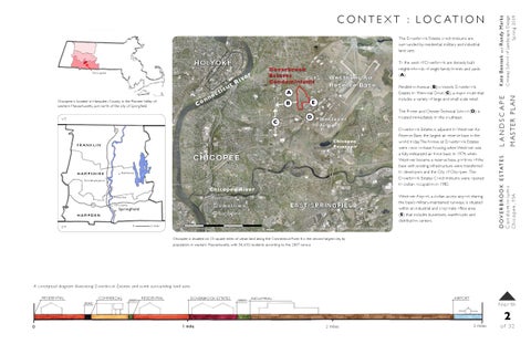
Chicopee is located in Hampden County in the Pioneer Valley of western Massachusetts, just north of the city of Springfield.
v
Doverb ro o k E s ta tes Co n d o m in iu m s
We stove r Air R e se rve Ba se
A E
B
VT
C
D
Wes to v er Ai r p o r t
91
Chicopee Reservoir
FRANKLIN
CHI CO P E E HAMPSHIRE
A mherst
Nor t ham pt on
Chicopee River Ho lyo ke
Springfie ld HAMPDEN 0
CT
EAST SPR INGFIELD
Downtown C hic o pee
Chic o pee
90
5 m i l es
1 1
0
2 miles
Pendleton Avenue (B) connects Doverbrook Estates to Memorial Drive (C), a major route that includes a variety of large and small scale retail. The Porter and Chester Technical School (D) is located immediately to the southeast. Doverbrook Estates is adjacent to Westover Air Reserve Base, the largest air reserve base in the world today. The homes at Doverbrook Estates were once on-base housing when Westover was a fully militarized air force base. In 1974, when Westover became a reserve base, portions of the base with existing infrastructure were transferred to developers and the City of Chicopee. The Doverbrook Estates Condominiums were opened to civilian occupation in 1982. Westover Airport, a civilian access airport sharing the base’s military-maintained runways, is situated within an industrial and corporate office area (E) that includes businesses, warehouses and distribution centers.
Aerial photograph courtesy of Microsoft Corporation and NAVTEQ, c. 2009.
M AS T E R PL A N
Ri t icu t c ne n Co
er
Randy Marks and
Conway School of Landscape Design S p r ing 2009
C hi copee
To the west of Doverbrook are densely built neighborhoods of single family homes and yards (A).
Kate Benisek
H O LYO K E
LANDSCAPE
The Doverbrook Estates condominiums are surrounded by residential, military and industrial land uses.
D O V E R B R O O K E S T AT E S Condominiums Chicopee , MA
C O N T E X T : L O C AT I O N
Chicopee is situated on 23 square miles of urban land along the Connecticut River. It is the second largest city, by population, in western Massachusetts, with 54, 653 residents according to the 2007 census.
A conceptual diagram illustrating Doverbrook Estates and some surrounding land uses. RESIDENTIAL
COMMERCIAL ROAD
GREEN
RESIDENTIAL
DOVERBROOK ESTATES
GREEN
AIRPORT
INDUSTRIAL
Nor th
2 0
1 mile
2 miles
3 miles
of 32