24 minute read
Drones in Construction

William Adams1 Tara Brooks2 John Meneely3 Rori Millar4
1 &4 Felix O’Hare & Co. Ltd, Newry, Co. Down. 2 &3 School of Natural & Built Environment, Queen’s University Belfast, Co. Antrim.
Advertisement
E-mail: 1williamadams@felixohare.com 2 t.brooks@qub.ac.uk 3j.meneely@qub.ac.uk 4rorimillar@felixohare.com
Abstract - Drones are rapidly becoming widely adopted within the construction industry with a 58% annual growth rate in use. Benefits arise due to the unique perspective achieved through the data captured. These include improved documentation, operations, and productivity gains. Drone technology can be implemented to monitor progress, aid in health and safety inspections and assist quality assurance through specialist thermal imaging cameras. Construction companies can benefit from Photogrammetry outputs such as orthomosaic drawings, topography surveys, and 3D model generation. A case study in the development of a drone programme by a building contractor found that developing an inhouse team allowed more scalability and flexibility to carry out drone flights to meet the needs ofspecific projects. A qualitativereview found thatthere are time savings achieved on a project through drone data captured, however this is difficult to accurately quantify. Photogrammetry can increase the benefit of drone outputs in construction, for instance through volume calculations, validation of work to date, and communication to the project team through image annotation. Drone data is a tool that can be used to aid in the management of a construction project but does not replace the need for human interpretation. Looking to the future, drones can become more integral to the construction project through hardware development by adding attachments to the drone for specific tasks such an exoskeleton for internal building inspections or stakes for setting out coordinates. Software development will play a major role in construction drone use with the implementation of 5G to autonomise and speed upthe drone data transfer and enable integration with other platforms.
Keywords BIM, Case study. Construction, Drones, Integration.
INTRODUCTION
Drones are moving from niche to mainstream practice within the construction industry, as reliability of use increases along with quality and decrease in cost of adoption. A drone is an Unmanned Aerial Vehicle (UAV) which can be controlled remotely or autonomously through a variety of sensors and an onboard Global navigation satellite system (GNSS). In 2018, 32% of construction companies used drones on site. This represents a growing trend - a 58% annual increase in drone use was recorded by the NBS from 2017 to 2018 [1]. The growth of the drone industry is set to continue; it is projected that by 2030 there could be over 76,000 drones in general use with over 4,800 used in construction [2]. This rise in popularity can be attributed to several factors –according toa 2021 survey, 86% of construction firms found using drones helped them improve documentation, 56% cited improved operations and 47% cited increased productivity [3]. There is a wide array of options in terms of manufacturers and specifications for commercially available drones, which fit most needs and budgets. The reliability of drones has also increased, and most commercial drones now come with obstacle avoidance as standard, which reduces the chance of damaging the drone, property, and people around it, making it safer to operate on a busy construction site. Image quality has increased through higher resolution cameras and gimbals (to which the cameras are attached to reduce camera vibration) resulting in better image quality. Finally, as competitors are offering drone capability to construction clients, organisations are under pressure to compete and include the use of drones in the services that they can provide.
Any company undertaking a drone programmemust consider several key factors. Of most importance
are the regulations for commercial UAV flights within the country the business operates. Other factors to consider include the type, size and scale of the projects to be undertaken, and the range of data that is required against the specifications and cost of the drone. The camera is the main output component of a drone; therefore, companies must consider the required attributes in terms of quality, range of motion and capabilities, such as video or thermal imaging that are required from the drone’s camera. Some premium drones offer interchangeable cameras for different uses. A prospective drone programme should also ensure that the drone manufacturer’s guidelines, such as operational temperatures, maximum wind conditions as well as take-off and landing zones, can be met, as different drones may require certain weather conditions for optimal flight affecting the number of days it can operate.
Finally, in this market many specialist third party companies can provide all the drone services necessary to operate and deliver the data required, mitigating the need to undergo the research, training and costs associated with developing an in-house program. This is a viable option for many construction companies as they get the benefits that drone data provides without the upfront costs and investment of setting up in-house capability.
TYPES OF DRONES
Fixed wing and multi-rotor wing drones are the two main types of drones used in construction. Fixed wing drones have a rigid body and rely on thrust from a propeller to move forward while the wings provide the lift to remain at a constant altitude, therefore they cannot remain stationary once in the air. Benefits of the fixed wing system include greater stability in higher wind conditions through better aerodynamics. Also, due to the energy efficiency provided by the fixed wing design they can travel longer distances, with some commercially available fixed wing drones covering 5km2 over a 90-minute flight time on one battery [4]. Fixed wing drones require pre-programmed flights which are then completed autonomously with no manual interaction required, the onboard camera remains at a fixed position and cannot be adjusted, therefore extra consideration needs to be given to pre-flight planning. These drones are primarily used for large scale projects, such as corridor mapping for road construction.
Multi-rotor drones are made up of a body and several rotors that use the rotation of each propeller to provide lift to the drone. The most commonly manufactured type of a multi-rotor drone is a quadcopter (4 propellers) while some multi-rotor drones have up to 6 or 8 propellers that can accommodate higher payloads such as high-quality camera rigs or compact LiDAR scanners. Due to the energy output required to provide lift on a multirotor drone, a higher capacity battery is required to power each rotor which increases the weight and decreases the duration of a flight - most quadcopters manage a 25-35-minute flight time [5]. Many drones are now fitted with obstacle avoidance systems in multiple directions to prevent crashing in both autonomous and manual flight modes. Software applications are available for multi rotor drones to achieve fully programmable and repeatable flight paths for site surveys and inspection, similar to those for the fixed wing operations.
APPLICATIONS OF DRONES IN CONSTRUCTION
Fundamentally drones provide a unique perspective in data capture for the progress of a construction project. They provide a point of view which is not possible or practical with other image and data capture techniques.
a) Progress Monitoring
Drone imagery provides the wider project team with information on the activities completed to date on site. Publishing this information can save the wider team time travelling to site, enabling them to add annotations and come to an understanding of any issues or add commentary on site progress. These annotations can enable better communication between parties seeking approval for permits, method statements or other processes decreasing the time taken for approvals and down-time for activities on site. The image and video produced by a drone serves as a record of any activities undertaken to date of a construction project. Furthermore, aerial imagery can aid in programme management, identifying areas in which activities can start ahead of schedule and increase project programming efficiencies. Drone imagery can also contribute towards better logistics planning for setdown areas, storage compounds, vehicle routes or crane positioning. Through the use of CAD software, the images can then be overlaid onto construction drawings to provide scale to the images and understanding of the site context. This in turn allows for accurate measurements of areas of vehicle access, crane jib extents, and further detail to the coordination of trades.
b) Health, Safety & Security
Drones can also be implemented for health and safety monitoring on sites. Their use removes people from any hazardous areas where land-based inspections might result in injury, such as slips or trips which represent 47% of fatal accidents in 2019-20 in construction in the UK [6]. Other hazardous situations where drones provide benefit include surveying of structurally defective structures, in proximity to chemicals or similar materials, difficult to access areas, areas where heavy machinery is operational, or uneven surfaces. Drones can aid health and safety inspections and provide records for areas of work which may not be easily investigated through land-based site inspections. In addition, regular drone inspections on site can act as a deterrent for cutting corners, as site activity is documented in the drone imagery which can cover the entire site in a short period of time. However, drones may cause their own risks through malfunctioning equipment, collisions or low altitude flying which in congested construction sites with plant and equipment may present its own challenges; however, these risks can be reduced through pre-flight check lists and risk assessments.
Drones provide a quick and efficient way to survey and inspect large areas in a short time to check there are no unauthorised personnel within the site boundary. It also provides a quick examination of the condition of site hoarding to identify any weak points which may allow trespassers, avoiding injury and protecting the high-value equipment and plant from theft. Frequent flights may act as a deterrent to individuals considering trespassing onto a construction site.
c) Quality Control
There are a variety of multi-rotor drones with interchangeable cameras, which permit the integration of thermal imaging for inspection. Some other models come with thermal imaging specifically in mind, such as the Autel Evo 2 Dual, Parrot Anafi USA and the DJI Mavic 2 Enterprise Dual. Their standard and thermal imaging integrated cameras are designed to identify differences in temperature. This can be utilised within the construction sector to identify leaks in the building envelope, heat loss, defective material, and along with the compact size are easy to transport to a multitude of sites quickly and easily. The use of thermal imagery provides instant validation and data on the built structure, therefore any defects can be corrected in a timely manner, potentially keeping the project on programme, and avoiding extensive rework or damage to other aspects of the works on site. Such examples include water ingress to building roofs which may damage partition walls, causing rework and delays to project completion.
d) Photogrammetry
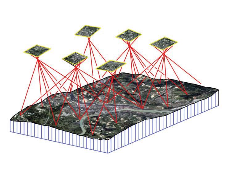
Photogrammetry can be integrated with the use of drone imagery to provide valuable data to contractors on site. Photogrammetry is a process in which 2 or more overlapping images taken of an area or object are processed, and the difference in perspective from each provides enough information for software to calculate the distance from the camera source through triangulation to regenerate that specific area as a digital tie point. This digital reconstruction gives 3 dimensional coordinates to the captured images and is based on the contrast within the pixels of the image. When this process is completed using drones over the context of a construction site, a 3D digital model can be created.
Fig.1: Photogrammetry Triangulation Diagram [7]
There are several software solutions which generate construction specific photogrammetric outputs including Pix4D, Drone Deploy, Context Capture, and free open-source platforms such as MeshLab. The use of drones provides the ability to capture the whole site in a short period of time. Automated flight paths can be created through photogrammetry applications, ensuring consistent overlapping between images which allows for an increased quality and repeatable output over time throughout a project. Several factors influence the quality and detail of the results, these include the distance of the drone to the subject, the resolution of image produced by the camera and the amount of overlap between images. Outputs provided by such software include orthomosaic imaging, 3D topographical surveys and 3D models.
Orthomosaic images produce an ortho-rectified image of the area captured. This can be used to provide improved perspective of the site compared to standard images, over a larger site. The 3D
topographical survey can provide bulk dig/fill calculations for measuring volumes of material to be transported to and from site. This is generated through coordinated CAD exports which provide the 3D coordinates from the captured data. This can be a more accurate and time efficient manner than land-based survey methods, dependent on the area and volume of material to be calculated.
Finally, 3D models can be generated through the photogrammetry software, through textured mesh models or point clouds. Point clouds can be importedinto CAD software to recreate existing site context, structures, or specific site elements required to complete or interpret the design of the building. The point cloud can also be imported into a project Common Data Environment (CDE) to validate or quantify work completed to date, ensuring the correct coordinates of components such as civils infrastructure, structural elements, site boundaries and building facades.
Increasing availability and support of web-browser viewing for outputs of photogrammetry from DroneDeploy and Pix4D Cloud allow the information captured from drones to become more accessible to the project team and shared with external stakeholders. Previously, restrictions of software licenses and the need for highperformance computers limited sharing and viewing of data. Using web-based applications, the entire project team can inspect the generated 3D model at greater detail further advancing their understanding of the project.
CASE STUDY
Felix O’Hare & Co Ltd (FOH) are a building contractor based in Northern Ireland whose work concentrates on commercial building projects with a typical value of £2 - £50 million. Their investment in drone technology began in 2014, with a purchase of a multi rotor, DJI Phantom 2. This drone was used on key projects for progress images throughout construction and to aid in programme management and scheduling activities. At the same time, several projects within the company outsourced their video production to third party companies who provided edited drone videos for client teams and marketing.
The use of drones in the company progressively increased to cover most new build projects, as a growing number of clients requested monthly drone footage within their specified project deliverables. In 2017, as the demand for drone images and videos from clients increased, FOH invested in a DJI Mavic Pro – one of the first compact, foldable multi-rotor drones with 4K video capability. This drone was chosen primarily because of its compact size which made it easier to transport to multiple sites. In 2019, 3 employees undertook training to achieve commercial licensing for drone flights within the UK. This was to ensure there would always be a qualified drone pilot available for any flight. All image and video production are now completed in-house, reducing cost and the reliance on third party specialists. This data now provides an overview of a project in a very succinct manner, making the data available to the project team, and providing material for marketing and social media engagement. Video editing is necessary on some projects to obscure confidential or sensitive information on neighboring properties, such as schools and government buildings.
At present the company collects drone imagery at least once a month on all new-build projects. This data is then shared on the projects’ CDE for the whole project team to access. On several key projects it is collected on a more frequent basis to ensure imagery is up-to-date and this digital information has become a key focal point for any progress or internal meetings. A Contracts Manager for FOH found that “the aerial imagery provided on a frequent basis allows for increased awareness of the site and opportunity for parallel working to find programming efficiencies.” However, due to the constantly changing environment of a construction site it is difficult to identify direct time savings from drone data as it is a multifaceted endeavour.It is also used for logistics planning and markup of areas to provide subcontractors with a better understanding of the site and its work sequencing. This data also provides a means to sketch out and plan set down areas for storage compounds, optimizing the use of the space on a site. Finally, the information is used by quantity surveyors to validate payments for subcontractors and serves as a record of the work completed to date.

Fig.2: Orthomosaic Image CAD Overlay with Annotations
Aerial mapping to provide 3D topographical surveys has been used on several projects which require large volumes of material to be transported off-site. This technique was validatedon one project against a site engineer’s land-based measurement method and tracked against actual volume unloaded. Since then, aerial mapping has been used for larger bulk digs, which takes less labour hours to calculate results.
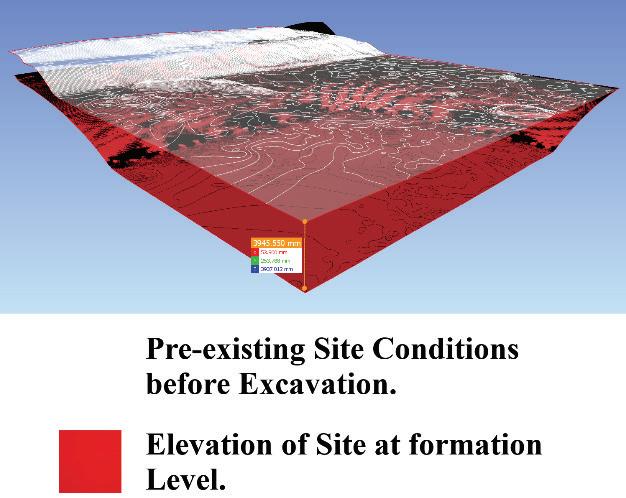
Fig.3: Topographical Survey Volume Calculations
However, for excavations that require a gradient or several changes in elevation, it is still necessary to export the drone topographical survey in CAD .dxf format and import this into surveying software to calculate the difference against the required grade to give a final cut/fill quantity. This provides the site team with an accurate estimate of how many lorry loads are required to transport the material and how many days are required for this transport.
This drone-based 3D topographical survey can also be imported into 4D Scheduling software, in which it is linked to the 3D design model and the project programme to produce a video animation of the progress of work and activities through the project. The animation includes the excavation or fill of material in order to show the groundworks subcontractor the stages and progression of work. This data is also sent to the Health & Safety management team to help identify any permanent or temporary works within the construction operations that may present a hazard.
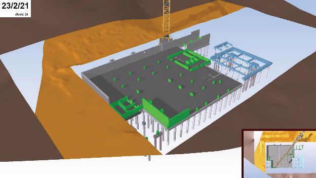
Fig.4: Topographical survey imported to 4D Programming
The company has developed other possible workflows for the use of drone data to further exploit its potential. Drone photogrammetry was trialed on the steel works construction of the new students’ union at Queen’s University, Belfast - a Building Information Modelling (BIM) Level 2 project with a fully developed BIM model. This trial looked at the accuracy of a drone generated point cloud of the steel works, with total station surveyed Ground Control Points (GCPs), compared to the design model. This was also tested against a ground based 3d laser scan data of the erected steel, collected on the same day using a FARO Focus S150, to compare the accuracy and time taken. The drone flight was completed within 30 minutes with no interruption to site activities. The laser scanning required 4 hours of on-site including halting construction works for several minutes in various locations in order to safely complete the survey.
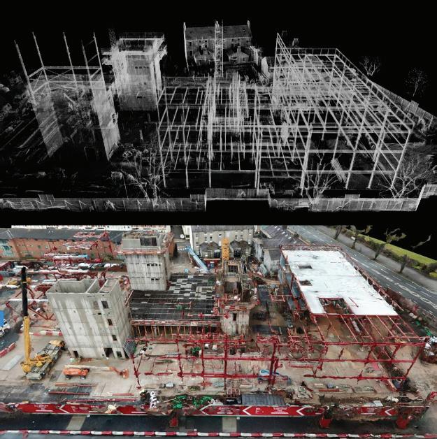
Fig.5: Comparison Between LiDAR Scan & Photogrammetry
This trial highlighted that, although the drone was
able to capture the overall site to a good level of detail, it struggled with the depth of field around the relatively thin structural steel. The data was captured using a DJI Mavic Pro with a 12MP image, - a drone with a higher resolution of camera should increase the detail; however, the processing of the data cannot capture the detail that is possible when compared to a terrestrial laser scanner. Due to the strict tolerances and detailing of structural steel, drone photogrammetry is not the optimal validation tool. However, when used for validation of for example, manholes and drainage lines, it has proven to be extremely useful.
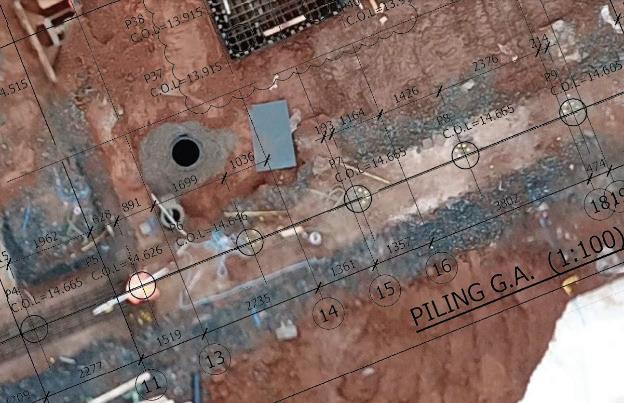
Fig.6: Validation of piling Location between CAD drawing and Drone Photogrammetry
This trial has shown that the integration of both ground based LiDAR and drone photogrammetry provide an optimal approach for validation and verification of built components on this site.
In the future it is proposed that the drone integration for Project Management within the company will grow, and mapping tools will be used on a weekly basis across all suitable projects. The adoption of a higher quality camera system should increase the image and video recording quality and a heavier drone will improve stability in high wind conditions, increasing the possible number of flying hours per project.
THE FUTURE
The increase in drone uptake within the construction industry will encourage the development of drone hardware, software and use cases for the specific intent of the industry’s requirements. With regards to the hardware within drones, developments will include 4K imaging and video recording, along with increasing battery life for most applications and use-cases within construction.The authors contend thatthe main area of development will be towards software and for extraction and interrogation of the data. a) The Connected Job Site
With the current standard of autonomous flights, the next progression will lead to completely autonomous drones which are able to fly the same flight path throughout set intervals. Autonomy will extend to charging, and the data will be directly uploaded to the cloud for processing, which will be aided by the introduction of 5G networks. This will be difficult to achieve in practice, as the take-off and landing of the drone are the most complex and unpredictable part of the flight due to the movement of people and traffic, changing ground conditions and wind speeds. Barriers to adoption also include government regulation of airspace to allow unsupervised flights by responsible pilots. In case of an emergency, the autonomous drone may not be able to react in an appropriate manner to avoid other air traffic or obstacles such as cranes, which are commonplace on a building site. Currently, methods such as high accuracy sensors are being developed in order to try and mitigate the risks which occur in emergency and unforeseen circumstances. Another advancement under development is the use of communication between all aerial vehicles in order to identify where they are in space relative to each other. The use of artificial intelligence will be used to train drones to learn to deal with changing circumstances; however, these are in very early development and need to be tested rigorously before any government body will authorize the unsupervised flight of drones in an airspace [8]. A Vodafone Report continues to highlight the benefits of 5G connectivity with drones. They define this as a cellular-connected drone which is linked to a mobile network through a sim card, this cellular connection is more reliable that current Radio and Wi-fi transmission signal. It also allows drones to provide a live feed of drone imagery to the cloud while in flight, which will allow the project team to view the site in real time at specific times or activities without the need to travel to site; it will also equip drones with the ability to automatically upload data. The report also emphasises the importance that 5G would play in communication between aircraft, to avoid collisions with manned aircraft, and other unmanned aircraft in the area [9].
Furthermore, autonomous flights can only be completed in ideal weather conditions, as in high winds or during rainfall drones cannot operate. Therefore, weather reporting integration with the (virtual) cloud and drone needs to be established to programme acceptable flight conditions and
continuously obtain feedback in case of changes to weather conditions throughout the flight.
b) CDE Integration
As discussed above, the ability to automatically upload and process data to the cloud is the next step in order to streamline and advance drone workflows in construction. This will require collaboration between manufacturers and software providers to fully develop this capability. Platforms such as Drone Deploy currently have features which use an internet connection through a mobile device in order to upload flight imagery and video to their cloud database for processing. This processed data can then be imported into a Common Data Environment solution such as Procore, Dalux or Autodesk BIM 360. However, it remains the case that inspection and reporting of issues raised through the photogrammetry processing solution such as DroneDeploy or Pix4D, provides the most useful results, which would in this scenario create two different platforms in which issues would be raised and must be checked by the site team. The interoperability and communications through plugins between these two types of platforms (the Common Data Environment and drone processing platforms) is currently being developed, as the importance of drone data for construction is increasingly recognised and introduced to more projects as a key tool for project management and communication.
c) Drone Attachments
Another development which could see wide adoption within the construction industry is the use of drones for setting out the positioning of roads, buildings, services, or other external infrastructure. This technology at the time of writing, is being tested by developers including an Israeli based robotics company, Civrobotics. Their ‘Civdrone’ can stakeout up to 500 coordinates on a project per day using advanced kinematic and GPS positioning technology within the drone system to accurately mark points by using a robotic arm that pushes physical markers into the ground. Compared to manual setting out using traditional methods such as a GPS or total station, this provides a reduction in time with little or no reduction in accuracy. This feature could be particularly useful for large civils and infrastructure projects that cover several kilometres, decreasing the time and resources dedicated to setting out the required coordinates, and eliminating the possibility of human error [10] [11].
Fig.7: CivDrone Setting Out Product [11]
Caged drones are typically a multi-rotor drone which has an ‘exoskeleton’ which provides a protective layer to the propellers and body of the drone. This cage allows it to stabilise and avoid damage upon collision with any surface. This allows the drone to inspect enclosed spaces that are unsafe or too small for human involvement. This technology was created following the Japan Tsunami in 2011 to allow inspection of damaged buildings or to look for missing persons [12]. It has been adopted for further applications such as surveying excavations, caves, and nuclear power plants. However, due to the nature of the environments in which this drone operates, it does not totally prevent damage to the drone as it can be damaged by sharp objects or fall from collisions. Also, several additional attachments are required, such as lights and sensors to capture the data needed, which in turn, reduces the battery life of the drone.
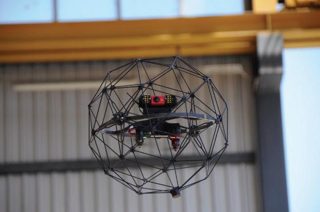
Fig.8: Elios 1 Caged Drone [12]
Construction organisations should also keep abreast of the capabilities that are expected to be developed in the future, as this is an ever-expanding area which has the potential to provide greater benefits to construction projects. There is continuing opportunity to include increasingly job specific
attachments and equipment to drones to automate tasks or capture more useful data.
CONCLUSION
Drones have proven to be a powerful tool when used in construction, and through their continual development they present more possibilities for the provision of useful information to the entire project team, relaying accurate information efficiently to complete and validate the project as required. In order to introduce drones, it is advisable for an organisation to develop a plan and to set goals for the benefits drones are expected to bring. When planning for the implementation of drones, a company should consider the set-up costs, data protection, legal requirements, insurance, training time as well as administration and documentation requirements of drone flights and identifying the person(s) within the organization best suited to carrying out drone operations. The company should also carefully consider what software they plan to use in order to process and export the data into a suitable format – this may require additional skills and software licenses, such as photo editing, video editing and photogrammetry software.
REFERENCES
[1] NBS. “National BIM Report” Newcastle, 2018.
[2] Price Waterhouse Coopers, 2018. “Skies without limits - taking the UK's economy to new heights.” https://www.pwc.co.uk/intelligentdigital/drones/Drones-impact-on-the-UKeconomy-FINAL.pdf, 2018.
[3] Drone Deploy, 2021. State Of The Drone Industry Report 2021. [online] p.10. Available at: <https://dronedeploywww.cdn.prismic.io/dronedeploywww/baee79b2-74a7-4e6d-b3aab523ea944fba_State+of+the+Drone+Market+2 021+ebook+v4.pdf> [Accessed 20 January 2021].
[4] senseFly. 2020. eBee X - senseFly. [online] Available at: <https://www.sensefly.com/drone/ebee-x-fixedwing-drone/> [Accessed 15 February 2021].
[5] Chapman, A., 2016. Drone types: Multi-Rotor vs Fixed Wing vs Single Rotor vs Hybrid VTOL. Australian DRONE magazine, (June). [6] HSE 2020. Construction statistics in Great Britain, 2020. HSE Annual Statistics. [online] Health and Safety Executive. Available at: <https://www.hse.gov.uk/Statistics/industry/con struction.pdf> [Accessed 15 February 2021].
[7] TheHighTechHobbyist. 2016.
Drone Photogrammetry: Make 3D Landscapes. [online] Available at: <http://thehightechhobbyist.com/dronephotogrammetry/> [Accessed 6 February 2021].
[8] Harwood, R., 2019. The Challenges to Developing Fully Autonomous Drone Technology. [online] Ansys.com. Available at: <https://www.ansys.com/blog/challengesdeveloping-fully-autonomous-dronetechnology> [Accessed 15 February 2021].
[9] Vodafone, 2020. The Benefits to Society of Regulated Drone Use. Cellular-connected drones. [online] WPI Economics. Available at: <https://newscentre.vodafone.co.uk/app/upload s/2020/01/Final_Vodafone-Drone-Report-WebPages.pdf> [Accessed 15 February 2021].
[10] Cousins, S., 2019. Drone-based setting out system trialled on site | BIM+. [online] Bimplus.co.uk. Available at: <https://www.bimplus.co.uk/technology/dronebased-setting-out-system-trialled-site/> [Accessed 15 February 2021].
[11] Civrobotics.com. 2020. Civrobotics Products. [online] Available at: <https://www.civrobotics.com/products> [Accessed 15 February 2021].
[12]Flyability.com. 2021. What Does a Drone Cage Do? Use Cases, Types, and Indoor Inspection Applications. [online] Available at: <https://www.flyability.com/drone-cage> [Accessed 28 June 2021].
