24 minute read
FiFty years oF Wilderness


By Heather MacSlarrow, Conservation Director
Years of Wilderness
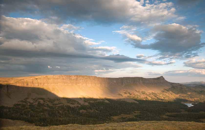
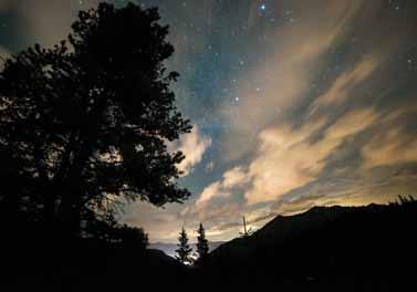
Summit Lake, looking into the Mount Evans Wilderness. Photo by Janice Bennett
Preservation vs. extraction
In 1492, when Columbus sailed the ocean blue, the lands now comprising the United States of America were inhabited by peoples who lived very close to natural systems. Some tribes subsisted on hunting and gathering, essentially dispersing the impact of their use across vast expanses. Some built longhouses and managed fisheries, containing human use to aquatic zones. And some cultivated crops and thinned forests, operating as an understated precursor to modern day land management agencies. Even with this use, Europeans found a continent largely driven by natural processes and rife with wildlands. Less than 500 years later, only 2% of the 2-billion-acre landmass of the U.S. would remain undeveloped, and a human population estimated to be as low as 1 or 2 million would grow to over 200 million (present-day population is more than 300 million).
European settlers, accustomed to smaller territories long turned agrarian, viewed these stretches of unbroken woodlands as foreboding, even sinister, something to be tamed and utilized for resources from which to build the new life they sought. This relationship with the land around us can still be seen today in our manicured lawns, paved parks, and successful timber and oil industries. European settlement introduced individual land ownership, reinforced houses, vast clearing and ploughing operations, and large town construction projects.
In 1900, one of the first public preservation vs. extraction debates emerged. The City of San Francisco, growing rapidly, was interested in damming the Hetch Hetchy to augment the municipal water supply. The Hetch Hetchy, being located in yosemite National Park, was a public good. John Muir, founder of the Sierra Club and widely renowned as one of America’s founding conservationists, fought long and hard to protect the Hetch Hetchy. In the end, although the valley was dammed, a preservation movement had begun.
When the United States Forest Service (USFS) and National Park Service (NPS) were created (in 1905 and 1916 respectively), they were the first established public preservation and management systems in the U.S. Even their creation personified the push/pull of extraction and preservation— their dichotomy of purpose was written into agency legislation. The mission of the USFS is: “To sustain the health, diversity, and productivity of the Nation’s forests and grasslands to meet the needs of present and future generations.” The NPS is tasked to: “Conserve the scenery and the natural and historic objects and wildlife therein, and to provide for the enjoyment of future generations.” While it is obvious that meeting the needs of present and future generations requires a healthful resource, there is no easy answer as to what constitutes such a thing. How much productivity should be pursued? Does more enjoyment happen in a Civilian Conservation Corps (CCC)-built lodge or an open meadow?
As the nation continued to grow, pressure on public lands and the preservation vs. extraction debate grew also. National parks became an ever-increasing public attraction, sparking a phase of intense development of recreation infrastructure in parks, especially after the invention of the automobile. Suddenly roads pierced to the heart of the wilds, and rustic lodges and chalets dotted the backcountry. In response, during the 1930s, conservation ethics were introduced into public land management. Interior Secretary Harold Ickes pushed to establish national parks that would be managed as wilderness as opposed to recreation meccas. The Everglades, kings Canyon,
Lone Eagle Peak, Indian Peak Wilderness. Photo by Craig Fagerness
Olympic, and Isle Royale were created with this intention. In 1933, departing NPS Director Horace Albright urged Parks personnel to “Oppose with all…strength and power proposals to penetrate…wilderness regions with motorways and other symbols of modern mechanization.”
Although there were agency staff in support of preservation, conservation enthusiasts were beginning to doubt that agencies could effectively protect areas given their opposing mandate of resource use through extraction and recreation. A study conducted by Dr. James P. Gilligan in 1953 underscored this concern and warned of rapidly shrinking areas of wildlands in the National Parks system owing to “the unrelenting pressures of mass use” and the obligation to “[exhaust]…every possible means of providing [the public with] accommodations.” The growing preservation movement longed for a more enduring protection that would not be impacted by changes in staffing or political trends. Bob Marshall, a forester and activist whose name would posthumously be given to a wilderness area, stated in 1934: “In order to escape the whims of politics…areas…should be set aside by Act of Congress. This would give them as close an approximation to permanence as could be realized in a world of shifting desires.”
In 1955, Howard Zahniser, then Executive Director of The Wilderness Society, penned the first draft of what would become the Wilderness Act. It would take nine years, 66 rewrites, 18 public hearings, 6,000 pages of testimony, and countless hours logged by dedicated conservationists to arrive at a passable document. On September 3, 1964, Public Law 88-577 was ceremoniously signed into law by President Lyndon B. Johnson in the White House Rose Garden. President Johnson characterized its importance thus: “If future generations are to remember us with gratitude rather than contempt, we must leave them something more than the miracles of technology. We must leave them a glimpse of the world as it was in the beginning.” The Wilderness Act carried with it permanent protection for 9.1 million acres of public land and the promise of a much greater network soon to follow. It forever changed the character of wilderness designation from a malleable administrative classification to a perpetual state bestowed only by Congress and became the focal point in the back-and-forth between preservation and extraction.
the Wilderness act
As poetic and ceremonious as it was, the Wilderness Act left much of the finer details of its enactment unclear. Prior to its passage, the Act was opposed by numerous entities: Commercial interests such as the American Pulpwood Association, American National Cattleman’s Association, and the American Mining Association were concerned for their ability to create and provide goods and services to the American people; recreationists were concerned for their ability to continue to visit their public lands; and land management agencies were concerned for their ability to effectively manage the lands entrusted to them. In order to gain widespread support and pass through Congress, the Wilderness Act, while clear in its passion and devotion to wildlands, provided a somewhat contradictory picture of how this goal should be achieved.
Wilderness was defined in the Act as “an area where the earth and its community of life are untrammeled by man, where man himself is a visitor who does not remain… an area retaining its primeval character and influence, without permanent improvements or human habitation, which…in general appears to have been affected pri-
Mt. Evans Lookouts. Photo by Fred Larke
marily by the forces of nature, with the imprint of man’s work substantially unnoticeable, has outstanding opportunities for solitude or a primitive and unconfined type of recreation, has at least five thousand acres of land or is of sufficient size as to make practicable its preservation and use in an unimpaired condition.” Wilderness was to be maintained in order to offset areas “where man and his own works dominate the landscape.”
The Act specifies that commercial enterprise, temporary or permanent roads, motor vehicles, motorized equipment or motorboats, aircraft or other mechanical transport may not exist in wilderness areas. However, it also allows for “non-conforming wilderness areas” and provides provisions for mechanical transport, mineral prospecting, use of range and water, and commercial enterprise associated with wilderness recreation. In addition, the Act expressly states that it shall not interfere with the Multiple-Use Sustained yield Act of 1960, which calls for the management of public lands to allow for “Multiple Use” (defined as “the management of all the various renewable surface resources of the national forests so that they are utilized in the combination that will best meet the needs of the American people”) and “Sustained yield” (defined as “the achievement and maintenance in perpetuity of a high-level annual or regular periodic output of the various renewable resources of the national forest without impairment to the productivity of the land”). Although the Multiple-Use Sustained yield Act was created to ensure that timber harvesting did not supersede the needs of recreation, range, watershed, and wildlife and fish, it still allowed for commercial extraction of renewable resources.
This ambiguity of legislative intent left many unanswered questions. What constitutes appropriate wilderness recreation? How many rafts? How many hikers and guides? How many tents? If airstrips already exist in wilderness, can they be used? How extensive should timber harvesting or mineral prospecting be or how quickly phased out? What about when broader human influence, like the introduction of nonnative species, the changing of the climate, or the pollution of air and water create alterations within wilderness areas? What about when gray wolves are reintroduced to the Frank Church River of No Return Wilderness and need to be tracked and collared via helicopter? What about when chemicals need to be used to protect native trout in the Carson Iceberg Wilderness? How about when climbing temperatures dry up water in the kofa Wilderness Area and water tanks need to be brought in for wildlife survival? If we rely on wilderness rangers to erase sign of wilderness travelers, isn’t that still leaving an “imprint of man’s work”? If bikes are regarded as mechanized, are not cell phones and MP3 players also mechanized? What if the use and enjoyment of one generation cannot leave land unimpaired for the use and enjoyment of future generations? What takes precedence—anthropocentrism or bio-centrism? How much decision-making power should be left in the hands of land management agencies, and how much should be determined for them?
Legal and scientific journals, newspaper and magazine opinion sections, and internet message boards are littered with suggestions on how the Wilderness Act can and should be interpreted and implemented. Debates arise over coffee, in town halls, and at hardware stores. As questions and disputes arise, they are ruled on by courts across the country. The resulting decisions have narrowed and more defined the Wilderness Act, leading to clearer implementation guidelines but also a deeper dislike for the Act in those that are opposed to preservation.
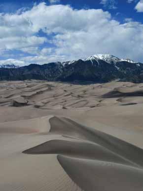
The wide expanse of The Great Sand Dunes bordering the Sangre De Cristo Wilderness. Photo by Frank Burzynski
Present day
Today, the National Wilderness Preservation System (NWPS) is comprised of 759 wilderness areas totaling almost 110 million acres in 44 states, accounting for nearly 5% of the landmass of the U.S. (3% of the continental U.S. and 16% of Alaska). In the 50 years that have passed since the signing of the Wilderness Act, every Congress has considered bills that would expand the NWPS. In the eyes of Aldo Leopold, John Muir, Mardy Murie, and all of the other countless conservationists who worked tirelessly for its creation, a resounding success. And in the eyes of the generations still to come, a valuable resource they can always turn to even while urban centers and the human population grow exponentially.
The question now is how to continue to advance the lofty goals in the Wilderness Act while making sure the needs of all are met. One of the interesting effects of the Wilderness Act is how it has impacted the discussion around public land use. Due to its increasingly controversial nature, the Act has contributed to a widening chasm between the two ends of the land management pendulum: extraction and preservation. Die-hard preservationists have said that they would rather see all the timber in the land burn rather than be converted into commercial products. Ultra extractionists argue that man is part of the natural system and therefore should be unfettered in his interaction with the land around him, whether that leads to the desecration of all public land or not. Such polarity has given rise to distrust and suspicion on all sides. When motorized recreationists pursue their outdoor hobby, they are vilified and painted as lazy saboteurs who damage public lands, though as a group they have committed thousands of hours and large sums of money to land stewardship. When President Obama convened the White House Rural Council, which has invested millions of dollars in rural initiatives such as assisting homeowners in mortgage refinancing and accelerating job and new-sector growth, it was portrayed as a misuse of executive power that would force people off their land if they weren’t making money for the Administration’s green agenda. Land management agencies, tasked with managing a vast resource with an increasingly shrinking budget, are constantly under legal siege from all manner of interest groups and generally considered inept, though their collective staff carry a profound level of expertise. Public lands have now become the center stage of our nation’s political unrest. Last April, the Bureau of Land Management (BLM) and a private citizen engaged in an armed standoff over the question of whether landowners should pay taxes for utilizing federal resources for grazing and watering their stock.
In the question of wilderness designation, these dynamics contribute to a mounting tension that makes legislators leery of endorsing more wilderness legislation. The arguments for and against wilderness are numerous and as personal as they are widespread. Supporters cite the need for sustenance for the soul, bio-centric management actions, functioning natural systems, and solitary experiences that help to ground and enliven. Detractors see millions of dollars left unclaimed, preferential treatment of quiet use recreation, federal overreach at a local level, and a relentless advance that will only cease once all public land is designated wilderness. Each side views the other as a threat with intent to harm. How can such a visceral experience be argued? What is habitat protection for parents looking to clothe and feed their families? What is one more timber sale to those who see a world without water plunged into a war zone in their mind’s eye? And how can we value that which we do not know, such as the future price of carbon sequestration, water purification, oxygen generation, or solitude in a world beyond 8 billion? Most of all, what
the next 50 years
The answers to these questions are not readily accessible. What is clear is that we are a people dependent on both extraction and preservation. The air we breathe, the paper on which we document our lives, our shared outdoor experiences, all rely on this duality. Our need for these resources is bipartisan. So our advocacy for how to utilize them must also be bipartisan. No more should we berate each other for making different choices of how to spend time on our public lands, or for making value judgments on how best to care for ourselves or our families. Rather, it is necessary that we respect our differences and utilize them to build successful systems that create the strongest and most life-sustaining network of public lands possible. Companies mired in cycles of blame and distrust, and where short-term profitability and long-term fiscal sustainability are managed disparately, implode. If we continue on a path that pushes preservation and extraction farther and farther apart, the same fate awaits us.
Even though it would be impossible for all people to agree on individual values (sitting in silence atop an unnamed peak or driving a vehicle into the vast unknown), we all interact with land designation through national commerce. Through a strictly anthropocentric, business point of view, public land preservation is necessary because it acts as a savings account. If we desire to be fiscally responsible, we must keep a portion of our most valuable resources unspent. Extraction is necessary because it provides income and allows us access to the products we require on a daily basis. Lumber and mining are among the top 11 industries that create our nearly $17 trillion gross domestic product. So the question is budget: How much to save and how much to spend? Financial planners recommend saving between 10 and 30 percent of income. Translated into wilderness designation, this gives us a goal figure of public land to place into protection that still allows for necessary industrial use.
If we can agree to advocate and allow for both preservation and extraction, place a warranted amount of trust in our intelligent and hard-working agency staff, and accept each other’s wants and desires as valid, the next 50 years of the Wilderness Act will be as successful as the first. △
By Edward Nunez
Flat Tops Wilderness: Lost Lakes, East China Wall, and Devil's Causeway
Walking the rim of the East Chinese Wall on the Chinese Wall Trail on day three. In the distance is the Devils Causeway. Photo by Edward Nunez
Flat Tops Wilderness:
Round-Trip Distance: 19.5 miles
Round-Trip Time: 3 days
Elevation: 10, 280 to 11, 928 ft Type of Hike: Highly scenic; on-trail, easy off trail with an optional narrow and exposed crossing
Trailhead: Stillwater Reservoir, 17miles west of Yampa
We all have our favorite, even classic, Colorado alpine experiences. Mine are the views from Frigid Air Pass of Maroon Peak with the lush, green Fravert Basin fanning out below, the peaceful morning reflection of Dream Lake in Rocky Mountain National Park, and the view of the formidable and jagged Gore Range from Peak C.
And then there is the Flat Top Wilderness. It is definitely not a typical “alpine” experience. But this four-day backpack is as firmly etched in my psyche as any Colorado alpine experience I’ve had.
The Flat Tops Wilderness flies under the radar in Colorado. Although CMC members may know about it, to the general outdoor enthusiast it is largely unknown. Ask a fellow co-worker about the Flat Tops and you will likely get a blank stare.
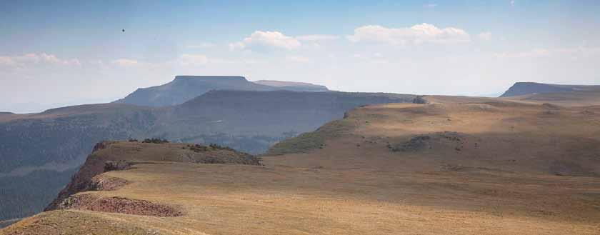
Located in the Routt and White River National Forests, the Flat Tops Wilderness is unique. Rather than jagged peaks and sharp spires, as the name indicates, the region is characterized by mesas. The landscape looks historic; looking at it, I often found my mind drifting into the thought that I was in the old country of the pioneers.
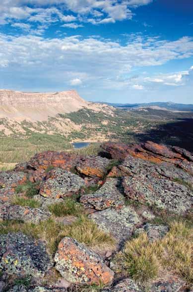
The Flat Tops Wilderness is considered to be the birthplace of the United States wilderness system. In 1920 it became the first property designated as off-limits to development on the recommendation of Arthur Carhart, Forest Service official, conservationist, and writer, who surveyed the Trappers Lake area for the U.S. Forest Service. It was designated as the Flat Tops Wilderness Area in 1975. The Flat Tops Wilderness has over 150 miles of trails, over 100 trout-laden lakes and ponds, and about 100 miles of fishable streams. It is the second largest wilderness area in Colorado.
My Flat Tops Wilderness hike was a three-day, 19.5-mile backpacking trip through a wonderful landscape of grand mesas and lush green valleys. This trip includes the challenge of an adrenalin-filled, exposed and narrow crossing, the Devil’s Causeway. But if you are not fond of heights, an alternative trail bypasses the causeway, adding about two miles to the trip. Day One: To Round Lake
My trip began with two other friends, Dave and Beth. Our plan was to spend the first two days and nights together, part ways on the morning of day three to do different loops, and meet back at the car the morning of the fourth day.
The hike began with a moderate uphill climb (1,300 feet in 1.6 miles) to the pass at 11,600’. Up to this point, the scenery was all about the grand and startling views of giant mesas. Staring at this landscape, it was hard to believe I was in Colorado. When we reached the top of the pass the view changed dramatically. Beneath me was a lush green valley, the East Williams drainage, dotted with several lakes. But on my left rose an impressive dark, vertical rock wall that curved to the north and formed the west wall of the valley. This was the Devils Causeway, a narrow band of vertical mesa described in my guidebook
Evening reflections on Deep Lake, the second night campsite. Photo by Edward Nunez Morning of day three after camping at the pass just below Devils Causeway. Photo by Edward Nunez
In the valley of the East Chinese Wall from the Williams Fork Valley. Photo by Edward Nunez
as a “3-foot-wide, 1,500-foot-high gangplank.” This would be my route to cross on day three to complete the loop! A feeling of dread and excitement swept over me.
After a good break at the pass, our gang of three strapped on our packs and descended down into a pleasant valley filled with spruce and fir trees. Our destination for the day was Round Lake, which is at the intersection of the Lost Lakes Trail and is little more than five miles from the trailhead, where we made camp. I gave the lake a try with my fly rod but had no luck.
Day Two: The Lost Lakes
Day two was an easy hike four or five miles further down the valley into the Lost Lakes area, where there are many options to camp at lakes and creeks. After seeing these lakes and terrain, I recommend not camping at Round Lake. The lakes further down the Lost Lakes Trail are more scenic and inviting. West Lost Lake has many good campsites, including a very large one with many tent sites on the hill on the west side of the lake.
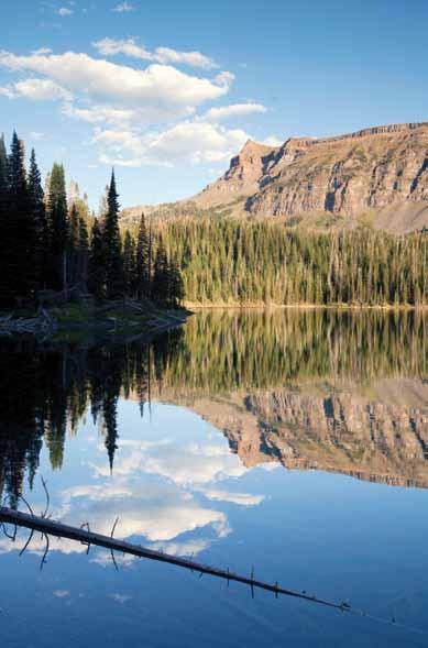
Our group camped at Deep Lake, which involved a short quarter-mile scramble from the Lost Lakes Trail. Deep Lake is a scenic spot located up against the East Chinese Wall. Both Dave and I tried our fly rods. There were fish in the lake, but we had no luck. Dave and Beth decided to hike back along the trail and fish the larger East Lost Lake. Hours later, Dave returned from East Long Lake with a sixteen-inch trout, the largest he had ever caught in the backcountry—and Dave has fished a lot of places.
That night we discussed our plan for day three. Dave and Beth would hike the Lost Lake Trail that loops around and returns to Round Lake and would camp at Causeway Lake just below the climb up to the pass at the causeway. I would climb west out of the valley, hike along the rim of the East Chinese Wall, cross Devil’s Causeway, and camp somewhere along the first two miles from the trailhead. We would meet at 10 a.m. on day four back at the car.
Day Three: A Walk Along the East Chinese Wall and Crossing Devil’s Causeway
I was excited for this day. I had read about this trip in my go-to guidebook, 100 Classic Hikes in Colorado, by Scott S. Warren. This guidebook has been a bible for me and has absolutely taken me to the best hikes and backpacks in Colorado.
I woke in the dark for an alpine start. Almost all of my alpine starts have been done to err on the side of to safety: Longs Peak, Capitol Peak, Rainier, kilimanjaro, and others. But this start was due to excitement, to experience the sunrise, to hike up the trail in the dark, and to hear the soft crunch of my boots on the trail.
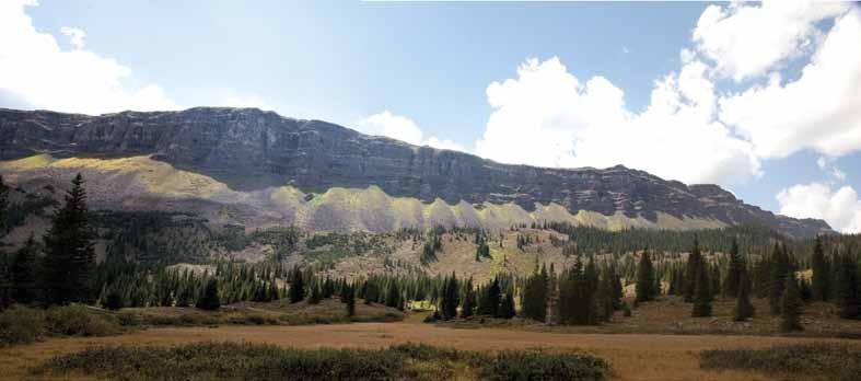
I began climbing out of the valley on the Chinese Wall Trail. It was a windless morning and the sky to the east was dark blue and violet with orange at the horizon; this is what makes an alpine start special. After gaining the top of the mesa, the trail becomes spotty, turns east, and arrives at the rim of the East Chinese Wall. The mesa is a half-mile wide and drops off steeply on both sides. The western wall of this mesa is officially named on topo maps as the Chinese Wall and can be prominently seen from Trappers Lake, a popular destination by car in the Flat Tops Wilderness. It is more vertical and taller than the East Chinese Wall.
Standing on the East Chinese Wall, there is much to see. To the south is a half-mile of flat mesa with Trappers Lake in the distance. To the east and directly below is the Lost Lakes area and Deep Lake. To the southwest there are many broad and flat mesas stretching out as far as the eye can see.
Walking along the top of the East Chinese Wall for the next four or five miles was the highlight of the trip. The mesa top was mostly lumpy grass and tundra and the trail was nonexistent in most places. I had the freedom to choose my own route. For the most part I stayed close to the rim, to be able to see down into the valley. Occasionally, I hiked out to a small outcropping, dropped my pack, and took in the view. I also hiked over to the western rim to look down on Trappers Lake. Like a good book that you know is special from the first page, I didn’t want to rush this day. In his 100 Classic Hikes in Colorado, Scott Warren writes, “there is something special about hiking across this treeless terrain; it constantly seems as if you are looking down upon the rest of the world.”
In the early afternoon, after a good day of carefree hiking, the view of the lush green valley ends abruptly as it smacks up against it is southern border, the Devil’s Causeway.
A few days earlier, we had meet backpackers who were not crossing the causeway and relayed that the Flat Tops ranger said that he personally would not cross the causeway with even a daypack. And here I was after a long day, with a heavily laden backpack, including an extra 10 pounds from my camera, tripod, and fishing gear. I hiked over to the neck of the crossing and rested in a pile of rocks. It had clouded up and was much darker than an hour before, and a stiff wind blew. I hadn’t seen anyone all day. I looked over to the crossing and there, off to the right side, propped up by rocks, was a small, three-foot high wooden cross. Aided by my sweat-soaked shirt, a chill went right up my spine.
I saddled up my pack and looked out over the causeway. The causeway was about three hundred yards long but I could see that some sections were a very comfortable twenty yards wide and had a dirt trail down the spine. I had no idea if the crux was right before me or on the far side. The initial section was maybe six feet wide. The rock was solid but lumpy and parts of it stuck up. My main concern with the weight of my backpack was to avoid tripping. I then reached a wider dirt stretch that continued to get wider. The initial section had been the crux. Then I was across.
Back at the saddle, I had a decision to make. The weather was cloudy but not threatening. Here I was with a grand view, and a great day behind me. I decided to try and make it even better by camping at the saddle and photographing that evening and the next morning. I hiked down to Little Causeway Lake and brought up water for camp. That night, the weather cooperated. It was a clear and windless evening. As I went to sleep, the lights of Steamboat Springs flickered in the distance.
The next morning I woke up early to skies that were cloudy and stormy but clear to the east. Not what a backpacker wants to see, but for a photographer it could be ideal. Storm light always has the potential to produce dramatic photographs. As the sun rose, bright patches of sunlight struck the East Chinese Wall and the clouds behind them. It was a dramatic and impressive display that lasted twenty minutes.
It was a great morning. From my camp at the pass, I could easily see the entire backpacking route in a large counterclockwise loop: the valley below, the East Chinese Wall, and a few hundred feet above me, Devil’s Causeway, now a much more familiar and friendly opponent. With a great trip now almost behind me, I broke camp and made the short hike down the trail to meet Dave and Beth. △
Spectacular morning storm light on the East Chinese Wall, after camping at the pass on the third night. Photo by Edward Nunez